Harlosh, Dunvegan, Isle Of Skye, Highland, IV55
- Land size
- 2 acres
Key Features
- Completed development value well in excess of £500,000
- Beautiful location on the Isle of Skye
- Large Plot with Planning Granted
- Extensive ground work in place
- Ready for completion with major works completed
- Excellent access and amazing views
- All work has been carried out to an extremely high standard
- Bid now! To avoid missing out
Description
A rare opportunity to acquire an exceptional coastal site of approximately 2 acres in one of Skye's most breath-taking locations.
Planning permission granted and work started so planning runs in perpetuity.
The property extends across both sides of the township road, with approximately 1.5 acres on the elevated build side, featuring a natural fresh water spring, a picturesque burn, and a tranquil lochan that together create a truly unique setting. A further 0.5 acres lies on the sea side of the road, where the burn continues its journey down to the shoreline - offering your own private stretch of coastline and direct access to the sea.
The views are simply extraordinary. To the front, uninterrupted panoramic vistas sweep across Loch Bracadale towards the dramatic Cuillin mountains, while to the rear the iconic MacLeod's Tables rise beyond open grazing fields where sheep roam peacefully, adding to the authentic Highland atmosphere.
The site benefits from established trees along three boundaries, providing both shelter and privacy, while existing infrastructure includes a shipping container for storage and two block-built sheds complete with electricity and water supply already connected.
Combining natural beauty, privacy, water features, coastal access, and awe-inspiring scenery, this is an increasingly rare chance to secure a spectacular piece of the Isle of Skye with endless lifestyle or development potential.
Access to both parts of the site is from the quiet township road.
Work was started under a previous Planning Permission:
Full planning permission was previously granted in June 2009 for the erection of a single or 1 ½ storey property under planning reference number 10/03629/FUL. Interested parties are advised to contact Highland Council Planning Department directly by telephone at for further information.
With a realistic completed market value of over £500,000 in extremely sought after location on the Skye coast.
Site works installed include:
Kerbed bellmouth and driveway, including in excess of 600mm depth of well compacted rock to the driveway
Ducted road crossing
Whole build area cleared and well compacted rock installed to build area plus around a 3m strip around it
Reinforced concrete strip foundations,
Foundation concrete is over specified at 900mm width
Includes internal load bearing wall provision and fireplace base
Internal footings can merely be ignored if not required
Trench blocks laid from foundation concrete to expected approximate DPC level
Internal of build footprint infilled with rock, well compacted to within appx 300mm of DPC, >900mm depth
Land drainage installed to the site where a possible requirement, all future proofed
Surface water drainage provision
Around the build area ready for fall pipe installation
Includes full sized road gully for the drive which is laid to fall to it
Most is set to drain through the road crossing and inspection chamber, some drain via burn
Foul drainage installed
Multiple options provided for within the build area
Drain under the road to septic tank and soakaway with overflow to lower burn and then the sea
Electricity and water to site
Ducted to the block built shed on the build side of the road
Ducted into the build area
Ducted to the block built shed on sea side of the road
BT ducting/copper cable installed to build area, ducted under driveway and into the build area
Most of the site fenced.
New strainers and associated
New 14 foot gate for build side, having recently widened the drive access
12 foot gate for installation to sea side
New fence posts on site
Ballast on site to form concrete path between block built build shed and newly built block retaining wall to rear of block built shed
Path area excavated and rocked to accept concrete
Formed to fall to surface drainage
Laid to grass
Road frontage where kerbed
Driveway where kerbed
Area behind block built, build side, shed and around
Reinforced 300mm concrete slab to rear of garage of build area
Situated at the end of a narrow peninsula between Lochs Caroy and Bharcasaig (both of which are arms of Loch Bracadale), Harlosh is some 7 kilometres (4+1/2 miles) from the village of Dunvegan. Harlosh Island and Tarner Island lie just offshore, with Wiay some 3 kilometres (2 miles) distant to the south.
From seals basking on rocks to seabirds wheeling over the coast the Harlosh area invites you to an early morning low tide wildlife session or a late afternoon walk in search of otters along sheltered inlets. Family explorers can enjoy safe shore based wildlife watching or join guided sessions that teach kids about animal tracks and responsible observation. The variety of habitats here means you can choose an activity that suits your pace whether you are a first time nature lover or an experienced outdoor enthusiast
In nearby Dunvegan you will find everything you need, - from local grocery stores, cafés and restaurants to fuel stations, pharmacies and EV charging points. Enjoy fresh seafood at renowned local eateries, cosy cafés with stunning Highland views, and convenient access to everyday essentials, all just a short drive from the peaceful surroundings of Harlosh. Whether you're looking for outdoor adventure, quiet relaxation, or a taste of island life, the amenities close by make Harlosh the perfect base for exploring the Isle of Skye.
This lot will be sold under auction terms and conditions by Braveheart Auctions.
Speak to one of our dedicated team today for more information or visit our website.
Be Brave...Follow Your Heart
Braveheart Auctions hold land and property auctions every 2 weeks.
Do you know someone with a problem property?
Pass the details to Braveheart Auctions- We will sell it and we will pay you for the referral. Or speak to us about a FREE auction valuation.
Map Location
Property details
- Tenure
- Freehold
- Council Tax Band
- Ask Agent
- Date Posted
- 2026-08-08
Price history
| Date | Change | Price |
|---|---|---|
| 9 Oct 2026 | Reduced 3.1% (−£4,000) | £123,000 |
| 25 Sep 2026 | Reduced 5.9% (−£8,000) | £127,000 |
| 18 Sep 2026 | Increased 10.7% (+£13,000) | £135,000 |
| 11 Sep 2026 | Reduced 6.2% (−£8,000) | £122,000 |
| 4 Sep 2026 | Increased 8.3% (+£10,000) | £130,000 |
| 29 Aug 2026 | Reduced 4% (−£5,000) | £120,000 |
| 8 Aug 2026 | Listed | £125,000 |
Market Value Analysis
Compared with 75 Building Plots listings in Scotland (1+ acres).
Utilities & Restrictions
Utilities
- Electricity
- Ask Agent
- Water
- Ask Agent
- Heating
- Ask Agent
- Broadband
- Ask Agent
- Sewerage
- Ask Agent
Rights & Restrictions
- Public Rights of Way
- Ask Agent
- Private Rights of Way
- Ask Agent
- Listed Property
- Ask Agent
- Restrictions
- Ask Agent
Listed status, conservation areas and planning constraints for this location are in the full report.
Property Features
- Accessibility
- Ask Agent
- Parking
- Ask Agent
- Garden
- Ask Agent
Beyond the particulars: planning activity, flood history, heritage and ground risks, checked for this exact spot.
Connectivity
Broadband
Fastest speed available at this postcode
1 Mbps
Under 10 Mbps here
Suitable for
- Basic browsing & email
Mobile signal
Predicted 4G and 5G signal; indoor signal depends on building materials.
Ofcom Connected Nations postcode-level predictions. Speeds and signal are modelled, not measured, and vary between addresses and providers.
Signal is the easy part. Planning activity, flood history and protected designations here are in the full report.
Nearest Schools
Primary
- Dunvegan Primary School4 miles
- Pupils
- 45
- Type
- Non-denominational
- Edinbane Primary School6.6 miles
- Pupils
- 11
- Type
- Non-denominational
- Carbost Primary School8.3 miles
- Pupils
- 19
- Type
- Non-denominational
- Macdiarmid Primary School9.6 miles
- Pupils
- 22
- Type
- Non-denominational
- Bun-Sgoil Ghaidhlig Phort Righ11 miles
- Pupils
- 163
- Type
- Non-denominational
Secondary
- Portree High School12 miles
- Pupils
- 494
- Type
- Non-denominational
- Plockton High School32 miles
- Pupils
- 213
- Type
- Non-denominational
- Sgoil Lionacleit32 miles
- Pupils
- 263
- Type
- Non-denominational
- Mallaig High School37 miles
- Pupils
- 101
- Type
- Non-denominational
- Sir E Scott School37 miles
- Pupils
- 100
- Type
- Non-denominational
Distances are straight-line from the advertised location. Source: the national school registers (DfE, Welsh Government, Scottish Government) and Ofsted.
Schools are just the start: planning activity, heritage and any flood history here are in the full report.
Amenities
Supermarket
GP surgery
Pharmacy
Walking trail
Straight-line distances from the advertised location. Sources: NHS records, Geolytix supermarket locations, OS Open Greenspace and the national trails registers.
The area stacks up? Now check the location itself: planning nearby, protected designations and past flooding.
Getting Around
Nearest station
Nearest bus stop
Typical drive times
Straight-line distances from the advertised location; drive times are typical free-flow times over OpenStreetMap road data, so allow more at peak. Public transport locations from DfT NaPTAN.
Easy to reach matters. So do planning activity, flood history and ground risks: all in the full report.
Flood Risk
SEPA open data, checked around the advertised map pin for the listed acreage. Provided by LandSale, not the listing agent, and not part of the agent's particulars. Risk varies across a holding, so verify before committing.
Rivers and the sea
Surface water
Not at the pin: mapped about 20 metres away.
These bandings are the summary. Where this location sits on the flood maps, plus planning activity, heritage and ground risks, is in the full report.
Important notice: Information, maps and tags on this page are drawn from the advertising agent's marketing materials or generated automatically. LandSale has not verified them. Relying on these details is at your own risk, always carry out independent checks before committing to a purchase.
LandSale full disclaimer
Marketing information only - not formal particulars. The details on this website are provided for general guidance and do not constitute an offer or contract. Neither LandSale nor the advertising estate/land agent accepts responsibility for any inaccuracy.
1. Source of information
- Listing content: Core description, asking price, tenure, measurements, photographs and planning history originate from the marketing materials of the advertising estate or land agent. LandSale does not author this content and cannot guarantee its accuracy.
- Automated tags & categorisation: Property type, land-use class, acreage bands and similar labels may be applied by machine-learning models. They are intended as a helpful guide only and may not reflect the property's legal status or permitted use.
- Third-party & enriched data layers: Maps, boundary outlines, planning designations, soil reports, broadband coverage and other environmental or location-based insights are licensed from external suppliers. Such data are supplied “as is", may be incomplete or out of date and are subject to change without notice.
2. Verification required
Prospective purchasers must verify critical matters, including but not limited to planning permission, title boundaries, public rights of way, environmental constraints, acreage, services, access and VAT status, through their own inspections, specialist surveys, legal advisers and the selling agent before relying on the information or entering into any contract.
3. No warranty or liability
LandSale gives no warranty, express or implied, as to the accuracy, completeness or fitness for any particular purpose of the information displayed. LandSale shall not be liable for any loss, damage, cost or expense arising directly or indirectly from any use of or reliance on such information, save where liability may not be excluded by law.
4. Updates & feedback
If you believe any detail on this listing is inaccurate, please let us know. We will investigate and, where appropriate, update the listing or notify the agent.
© LandSale | Version 1.3 - August 2026

Listing agent
Braveheart Auctions Limited, Edinburgh
5 South Charlotte Street, Edinburgh, Scotland, EH2 4AN
Contact Braveheart Auctions Limited, Edinburgh
5 South Charlotte Street, Edinburgh, Scotland, EH2 4AN
View agent profileSimilar properties for sale
- Price
- Offers Over£120,000
- Size
- 15.1 acres
Added on 29/01/2026Building Plot
- Price
- Offers Over£105,000
Added on 05/06/2026Building Plot
- Price
- Offers Over£130,000
- Size
- 5.76 acres
Added on 15/09/2026Building Plot
- Price
- Offers Over£80,000
- Size
- 0.8 acres
Added on 29/01/2026Building Plot
- Price
- Offers Over£85,000
- Size
- 0.52 acres
Added on 09/09/2026Building Plot
- Price
- Offers Over£145,000
- Size
- 0.83 acres
Added on 29/01/2026Building Plot
- Price
- Offers Over£75,000
- Size
- 0.53 acres
Added on 29/01/2026Building Plot
- Price
- Offers Over£85,000
- Size
- 0.5 acres
Added on 22/07/2026Building Plot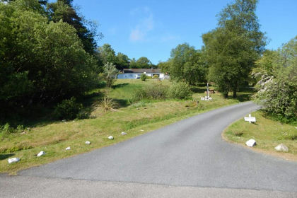
- Price
- Offers Over£100,000
- Size
- 0.4 acres
Added on 30/04/2026Self Build Plot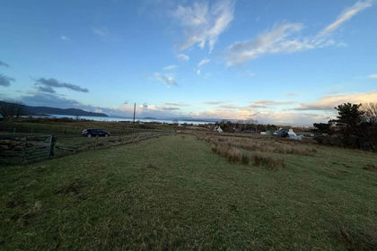
- Price
- Offers Over£90,000
- Size
- 0.26 acres
Added on 07/02/2026Building Plot