Ilsington, Dartmoor National Park
- Land size
- 7.5 acres
- Bedrooms
- 8
- Bathrooms
- 4
Key Features
- Five Reception Rooms
- Farmhouse Kitchen-Day Room
- Eight Bedrooms
- Four Bathrooms
- Two Bedroom Cottage
- Approximately 7.5 Acres With Stables
- Electricity Water Turbine And PV Panels
Description
A substantial and historic Grade II* listed country house set in some 7.5 acres with stream-fed ponds, countryside views and cottage, discreetly situated just below Haytor within Dartmoor National Park
Bagtor is a Domesday Manor, situated within the south Devon parish of Ilsington on the south-east slopes of Dartmoor. Bagtor House dates from the sixteenth century and was substantially enhanced in the early eighteenth century with the addition of an imposing Queen Anne-style facade with a seven window range across the upper floor and a portico entrance.
The interior of Bagtor House contains elegant panelled rooms with high ceilings, numerous period fireplaces, flagstone floors and whilst the accommodation is extensive it has a warm, homely feel. A separate stable building conversion provides two bedroom accommodation, perfect for an extended family member, housekeeper or letting (currently let at £975 pcm).
A driveway with granite gate piers and quadrant walls sets the property serenely back from the lane by some 120 yards. The house stands in approximately 7.5 acres (as measured on Promap) with south and east facing views stretching across south Devon towards the coast in the far distance. The land includes gardens with a former lawn tennis court, poultry/wild fowl run with duck pond, vegetable garden, and a sloping paddock with stables. In the field there are three large ponds fed by a moorland stream. There is also a leat-fed water turbine and an array of ground mounted solar panels, these combine to provide electricity to the house with any excess power feeding into the grid. Behind the house there is a large courtyard with marble fountain and an apple press.
Bagtor House also comes with historic Dartmoor commoners grazing rights.
The hamlet of Bagtor lies 3.5 miles north of Ashburton in a hidden valley below Haytor/Bagtor Down. The village of Ilsington is a 30 minute walk via the high-hedged lanes and has a pub, church, primary school, hotel with gym and an excellent village shop.
There is first class riding and walking literally on the doorstep including right of way access to the moor at Bag Tor and Bagtor Down with Haytor beyond.
The towns of Ashburton and Bovey Tracey (4 miles) each offer a great range of ever day shops and amenities whilst the larger market town of Newton Abbot (around 25 minutes' drive) has a mainline railway station with direct connection to London Paddington. The A38 is a ten minute drive and links the two Devon cities of Plymouth and Exeter (30 minute drive) with its international airport and connection to the national motorway network.
Council Tax Band: Main House - Band G, The Stables - Band B
Tenure: Freehold
History
Bagtor House and the manor of Bagtor are featured in several books and publications. According to the Historic England listing the present house dates from the 1500s at the rear (west) and the front wing (east) was added during the early 1700s.
The English playwright and poet John Ford was born at Bagtor House in 1586. The house has also been home to the eminent lawyer/politician John Dunning in the 1700s and various merchants over the years. The current owners acquired the property in 1996 and have restored the house and grounds during their tenure.
Accommodation
Portico entrance with two sets of tall double doors opens to the entrance reception room with its corniced ceiling, stone fireplace and wide wood floorboards. To the right is a formal sitting room with panelled walls, 'shell' cupboard and fireplace whilst to the left is an elegant dining room with panelled walls and white marble fireplace. A study with teak book shelving is positioned off an inner hall with flagstone floor, a cloakroom and the staircase to the upper floors.
Accommodation
The kitchen-day room is located in the rear wing in the older part of the house with lower ceilings, flagstone floor and a cosy feel centred around an ancient granite fireplace plus an electric four-oven Everhot range. There is a separate large pantry with slate slabs. A useful boot/utility room leads off the kitchen and connects to a garden room. At the far end of the building is a second spacious dining room with ceiling beams, flagstone floor, panelled walls, and a very large granite fireplace with bread oven. A lobby connects to a boiler/store room housing the oil-fired central heating boiler.
First Floor
Approached from a splendid, wide staircase rising to the first floor landing.
There are three east-facing (morning sun) bedrooms along the front of the building with wall panelling and countryside views, plus a nursery and bathroom. The rear wing contains a second bathroom and five more bedrooms including a large oak panelled bedroom with en-suite shower room and connecting door to a bedroom/dressing room.
Second Floor
On the upper floor there are two large bedrooms, a bathroom and attic store room.
Annexe
This is a detached single-storey building converted from the former stables between 30 to 40 years ago as a 'granny-flat'. It has an open-plan living area and kitchen, two bedrooms, bathroom and its own private garden area.
Gardens/Grounds
A gated gravel drive from the lane and flanked by areas of garden with mature trees culminates in a wide turning and parking area in front of the main entrance. The drive has a right-hand fork just before the main house with a secondary drive to the double garage building and the stable annexe.
Immediately to the rear of the main house is a walled courtyard with Indian marble fountain and large apple press. The gardens mainly lie to the south of the house with stunning far reaching views over countryside and neighbouring ancient woodlands. There is a lawn tennis court (not in current use but easy to re-instate), deep shrubbery and growing beds and a large area currently home to a variety of wild fowl with duck pond.
Gardens/Grounds
There is a timber stable building with two stables and tack room/hay store (water and electricity connected) beyond which is an area containing a large array of south-facing PV panels. Gated access is available to the paddock which is sloping and divided into two principal areas with a vehicular gate at the lower end to the lane.
Between the paddocks is an area containing three large ponds fed by a moorland stream, a haven for a wide variety of native wildlife.
A stone building houses the Pelton water turbine and generator which is fed by a leat coming off the moor.
Services
Private water supply and drainage. Private and mains electricity. Oil central heating.
Directions
From Exeter travelling west on the A38 take the Drumbridges exit and join the A382 towards Bovey Tracey. At the second mini-roundabout turn left on to the B3387 signposted Haytor/Widecombe. Continue along this road and bear left at Five Wyches Cross, following signs for Haytor/Widecombe. Proceed for just under three miles up on to the open Moor and turn left by the red telephone box signposted, Haytor Vale/ Ilsington. Stay on this road for 0.7 of a mile and fork right signposted Bickington. After 0.4 of a mile take the first right signposted Halshanger/Bagtor. The entrance to Bagtor House will be found along this lane after 0.7 of a mile on the right,
Directions
From Ashburton join the A38 in the Exeter direction and take the Goodstone exit signposted for Newton Abbot/ Bickington. At the end of the slip road take the left turning signposted Sigford/Widecombe. Proceed up this road for 2 miles and turn right at Halshanger Cross, signposted Bagtor. Follow this lane for 1.5 miles and the entrance to Bagtor House will be seen on the left.
Map Location
Property details
- Tenure
- Freehold
- Council Tax Band
- Ask Agent
- Date Posted
- 2026-07-31
Market Value Analysis
Compared with 514 Homes with Land listings in South West England (5+ acres).
Utilities & Restrictions
Utilities
- Electricity
- Ask Agent
- Water
- Ask Agent
- Heating
- Ask Agent
- Broadband
- Ask Agent
- Sewerage
- Ask Agent
Rights & Restrictions
- Public Rights of Way
- Ask Agent
- Private Rights of Way
- Ask Agent
- Listed Property
- Ask Agent
- Restrictions
- Ask Agent
Listed status, conservation areas and planning constraints for this location are in the full report.
Property Features
- Accessibility
- Ask Agent
- Parking
- Parking Available
- Garden
- Garden
Beyond the particulars: planning activity, flood history, heritage and ground risks, checked for this exact spot.
Connectivity
Broadband
Fastest speed available at this postcode
15 Mbps
Standard (10-30 Mbps)
Suitable for
- Web & social
- Music streaming
- Standard video calls
Fixed wireless access may also be an option here.
Mobile signal
Outdoor predictions; indoor signal depends on building materials.
Ofcom Connected Nations postcode-level predictions. Speeds and signal are modelled, not measured, and vary between addresses and providers.
Signal is the easy part. Planning activity, flood history and protected designations here are in the full report.
Nearest Schools
Primary
- Ilsington Church of England Primary School1.3 milesNo Ofsted rating
- Ages
- 2 to 11
- Pupils
- 95
- Type
- Academy converter
- Faith
- Church of England
- Blackpool Church of England Primary School2.9 milesOfsted: Good
- Ages
- 4 to 11
- Pupils
- 244
- Type
- Academy converter
- Faith
- Church of England
- Widecombe-in-the-Moor Primary3.2 milesNo Ofsted rating
- Ages
- 4 to 11
- Pupils
- 93
- Type
- Academy converter
- Ashburton Primary School3.3 milesOfsted: Good
- Ages
- 4 to 11
- Pupils
- 161
- Type
- Academy converter
- Bovey Tracey Academy3.6 milesOfsted: Requires improvement
- Ages
- 4 to 11
- Pupils
- 245
- Type
- Academy sponsor led
Secondary
- South Dartmoor Community College2.7 milesOfsted: Good *
- Ages
- 11 to 18
- Pupils
- 801
- Type
- Academy converter
- Coombeshead Academy5.7 milesOfsted: Good
- Ages
- 11 to 18
- Pupils
- 870
- Type
- Academy converter
- Newton Abbot College6 milesOfsted: Good *
- Ages
- 11 to 18
- Pupils
- 1,108
- Type
- Academy converter
- Teign School6.2 milesOfsted: Good
- Ages
- 11 to 18
- Pupils
- 1,111
- Type
- Academy converter
- South Devon UTC6.3 milesOfsted report card · Feb 2026
- Ages
- 14 to 19
- Pupils
- 184
- Type
- University technical college
* Latest graded judgement covers quality of education only; no overall grade was issued under the 2024-25 inspection framework.
Distances are straight-line from the advertised location. Source: the national school registers (DfE, Welsh Government, Scottish Government) and Ofsted.
Schools are just the start: sold prices nearby, planning activity and any flood history are in the full report.
Amenities
Supermarket
GP surgery
Pharmacy
Hospital
Straight-line distances from the advertised location. Sources: NHS records, Geolytix supermarket locations, OS Open Greenspace and the national trails registers.
The area stacks up? Now check the location itself: planning nearby, protected designations and past flooding.
Getting Around
Nearest station
Nearest bus stop
Typical drive times
Straight-line distances from the advertised location; drive times are typical free-flow times over OpenStreetMap road data, so allow more at peak. Public transport locations from DfT NaPTAN.
Easy to reach matters. So do planning activity, flood history and ground risks: all in the full report.
Flood Risk
From Environment Agency flood map open data, checked around the advertised map pin and allowing for the listed acreage where known. This summary comes from LandSale, the advertising platform, not from the listing agent, and is not part of the agent's particulars. Risk can vary across a single holding, so verify anything critical through your own searches before committing.
Rivers and the sea
Surface water
The detail behind these bandings
The full report pinpoints where this location sits on the flood maps, and runs the deeper checks that usually only surface after an offer.
- Exact flood zones & annual chances (included in the full report)
- Any recorded past flooding (included in the full report)
- Planning activity nearby (included in the full report)
- Heritage & conservation (included in the full report)
- Protected nature designations (included in the full report)
- Ground risks (included in the full report)
- Sold prices nearby (included in the full report)
£14.99 · one-off purchase
By LandSale, the platform. Not provided by the listing agent. Ready in about a minute.
Important notice: Information, maps and tags on this page are drawn from the advertising agent's marketing materials or generated automatically. LandSale has not verified them. Relying on these details is at your own risk, always carry out independent checks before committing to a purchase.
LandSale full disclaimer
Marketing information only - not formal particulars. The details on this website are provided for general guidance and do not constitute an offer or contract. Neither LandSale nor the advertising estate/land agent accepts responsibility for any inaccuracy.
1. Source of information
- Listing content: Core description, asking price, tenure, measurements, photographs and planning history originate from the marketing materials of the advertising estate or land agent. LandSale does not author this content and cannot guarantee its accuracy.
- Automated tags & categorisation: Property type, land-use class, acreage bands and similar labels may be applied by machine-learning models. They are intended as a helpful guide only and may not reflect the property's legal status or permitted use.
- Third-party & enriched data layers: Maps, boundary outlines, planning designations, soil reports, broadband coverage and other environmental or location-based insights are licensed from external suppliers. Such data are supplied “as is", may be incomplete or out of date and are subject to change without notice.
2. Verification required
Prospective purchasers must verify critical matters, including but not limited to planning permission, title boundaries, public rights of way, environmental constraints, acreage, services, access and VAT status, through their own inspections, specialist surveys, legal advisers and the selling agent before relying on the information or entering into any contract.
3. No warranty or liability
LandSale gives no warranty, express or implied, as to the accuracy, completeness or fitness for any particular purpose of the information displayed. LandSale shall not be liable for any loss, damage, cost or expense arising directly or indirectly from any use of or reliance on such information, save where liability may not be excluded by law.
4. Updates & feedback
If you believe any detail on this listing is inaccurate, please let us know. We will investigate and, where appropriate, update the listing or notify the agent.
© LandSale | Version 1.3 - August 2026
Listing agent
Howard Douglas, Ashburton
2 North Street, Ashburton, TQ13 7QD
Similar properties for sale
- Price
- Guide Price£1,500,000
- Size
- 6 acres
Added on 25/06/2026Country Home
- Price
- Guide Price£1,695,000
- Size
- 32.35 acres
North Bovey, Newton Abbot, TQ13, North Bovey, Devon TQ13 England
Added on 28/04/2026Farm
- Price
- Guide Price£1,550,000
- Size
- 40.85 acres
Tedburn St. Mary, Exeter, Devon, EX6, Tedburn St. Mary, Devon EX6 England
Added on 06/06/2026Farm
- Price
- £1,400,000
- Size
- 9 acres
Added on 04/06/2026House with Land
- Price
- Guide Price£1,650,000
- Size
- 4 acres
Added on 30/06/2026Country Home
- Price
- Guide Price£1,500,000
- Size
- 28 acres
Whitestone, Exeter, Devon, EX4, Whitestone, Devon EX4 England
Added on 26/06/2026House with Land
- Price
- Guide Price£1,400,000
- Size
- 5.14 acres
Sticklepath, Okehampton, Devon, EX20, South Tawton, Devon EX20 England
Added on 25/07/2026House with Land
- Price
- Guide Price£1,375,000
- Size
- 8 acres
Woodleigh, Nr Kingsbridge, TQ7, Woodleigh, Devon TQ7 England
Added on 11/05/2026House with Land
- Price
- Guide Price£1,750,000
- Size
- 6.55 acres
Shobrooke, Crediton, Devon, EX17, Shobrooke, Devon EX17 England
Added on 09/07/2026Country Home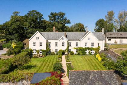
- Price
- Offers in Excess of£2,000,000
- Size
- 49.92 acres
East Village, Crediton, Devon, EX17, Sandford, Devon EX17 England
Added on 01/04/2026Farmhouse