The Woolpack, High Street, Sutton Veny, Nr Warminster, Wiltchire, BA12
- Use Class
- Use Class: E
Key Features
- Detached Wiltshire Village Pub - Currently Closed
- Presented In Excellent Order Throughout & Ready To Trade
- Open Plan Bar & Dining Area (40+), Commercial Kitchens
- Well Proportioned 3 Bedroom Owner's Accommodation
- Trade Terrace (30+), Owner's Private Garden, Car Parking
- Genuine Potential To Re-Establish Or Alternative Uses (STPP)
Description
The Woolpack is a character detached village pub which is well presented and equipped and which unfortunately closed in December 2022. This attractive and well proportioned country pub offers a delightful blend of classic and modern elements and briefly comprises:- Attractive Open Plan Main Bar & Dining Area (40+), well equipped Commercial Catering Kitchen with Ancillary Facilities, and 3 Double Bedroom Family Sized Owner's Accommodation with a Sitting Room, Kitchen/Dining Room and a Family Bathroom. Externally, the property benefits from an Attractive Patio Terrace (30+), an Owner's Private Garden Area and a Forecourt Parking Area. The Woolpack offers a quintessential slice of village life and a viewing is strongly recommended to fully appreciate all that this well presented property and turnkey business opportunity has to offer and the potential that exists.
SITUATION
The Woolpack occupies a prominent and visible, landmark trading position in the centre of the popular and sought after village of Sutton Veny, just off the A36. With an active community, the village offers a highly regarded primary school and has recently been voted West Wiltshire's "Best Kept Village" for 2025. Warminster (2 miles) offers a variety of shops and amenities including a Waitrose supermarket, as well as a station (Salisbury to Bristol line). The Roman City of Bath (21 miles), and the Cathedral City of Salisbury (19 miles), both offer a wider range of shops, cultural and recreational facilities. Trains from Westbury to London (Paddington) take about 1hr 20mins and from Salisbury to London (Waterloo) about 1hr 30mins. There is a wide selection of both state and private schools in the area, and many renowned places of interest to visit in the locality including the Longleat Estate, Old Wardour Castle, Sherborne Castle, Stourhead Gardens, Wilton House and Stonehenge.
INTERNAL DETAILS
Main Customer Entrance Door to the front leading into the Main Bar & Dining Area an attractive and easy to run open plan room with part stripped wood and part carpeted flooring, 2 feature fireplaces, one with an inset wood burner, the other is disused, part exposed brick walls, feature bay windows to the front, wall mounted menu boards, feature display shelving and wine racking, range of freestanding wooden tables, chairs, and stools comfortably seating 40 customers plus standing room. Painted timber fronted Central Bar Servery with a polished timber topped serve over counter, fitted with a range of associated back bar fittings, display shelving and optics, with non-slip flooring, 2 glass fronted bottle fridges, commercial coffee machine, electronic cash register, coffee grinder, glass fronted serve over refrigerated display counter, commercial glass washer and hand basin. Commercial Catering Kitchen with non-slip flooring, part stainless steel and part wipe clean clad walls and being fitted with a range of commercial catering equipment to include:- extractor system with gas interlock, 6 burner range, twin table top deep fat fryer, warming cabinet, eye level grill, turbofan oven, commercial microwave oven, 2 door under counter commercial freezer, upright commercial fridge, stainless steel work benches with shelving below, extensive stainless steel shelving, twin deep bowl stainless steel sink unit and a commercial dishwasher. Beer Cellar temperature controlled on the ground floor. Storeroom with racked storage shelving and the oil boiler. Ladies & Gents WC's.
OWNER'S ACCOMMODATION
Situated on the first floor is the well appointed, family sized owner's apartment which briefly comprises:- Sitting Room with aspect to the rear. Kitchen/Dining Room fitted with a range of base and wall mounted kitchen units and complementary worksurfaces. Part wood panelled walls. Bedroom 1 a double room with aspect to the front. Bedroom 2 a double room with aspect to the front. Bedroom 3 a double room with aspect to the front. Family Bathroom fitted with a bath and a separate shower cubicle.
EXTERNAL DETAILS
The pub stands in the centre of the village with a Forecourt Parking Area to the front. To the rear of the property is a lovely Patio Trading Terrace being fully enclosed with a raised timber decked area, feature lighting, borders and wooden bench seating for around 30 customers. Beyond this is an Owner's Private Garden Area which is fully fenced.
THE OPPORTUNITY
The Woolpack is presented to a high standard throughout and previously traded as a quality destination village pub and restaurant, located in the popular and sought-after Wiltshire village. The pub closed in December 2022 and our clients have moved on to new projects and careers. The potential to re-establish the trade is apparent, given the overall condition of the property which is still fully equipped with quality fixtures, fittings and trade inventory, making it ready to trade with limited additional investment required. The Woolpack represents an excellent opportunity to re-establish this well-regarded business, whilst diversification of the business should also be considered with new custodians being free to develop their own trading style, subject to the appropriate permissions. Many public houses that have ceased trading are left in a very poor condition, but this is not the case with The Woolpack and there is potential for hands on owner operators, or for commercial investors alike. The sale of The Woolpack represents an excellent opportunity to purchase an impressive country village pub and restaurant with family sized owner's accommodation. The Woolpack is a special place to live and work and a viewing is essential in order to appreciate the full potential that exists.
SERVICES
We are advised that mains water and electricity are connected to the property, LPG is used for cooking and there is oil fired heating and hot water. There is a private drainage system.
RATING
The rateable value on the 2023 list is £5,250. 100% Small Business Rates Relief will be available to eligible parties. For further details please contact the local authority, Wiltshire Council.
EPC
E - 109.
FLOOR PLANS
Available upon request.
Map Location
Property details
- Tenure
- Freehold
- Council Tax Band
- Ask Agent
- Date Posted
- 2026-07-17
Utilities & Restrictions
Utilities
- Electricity
- Ask Agent
- Water
- Ask Agent
- Heating
- Ask Agent
- Broadband
- Ask Agent
- Sewerage
- Ask Agent
Rights & Restrictions
- Public Rights of Way
- Ask Agent
- Private Rights of Way
- Ask Agent
- Listed Property
- Ask Agent
- Restrictions
- Ask Agent
Listed status, conservation areas and planning constraints for this location are in the full report.
Property Features
- Accessibility
- Ask Agent
- Parking
- Ask Agent
- Garden
- Ask Agent
Beyond the particulars: planning activity, flood history, heritage and ground risks, checked for this exact spot.
Connectivity
Broadband
Fastest speed available at this postcode
1 Gbps
Superfast
Suitable for
- 4K streaming on every screen
- Full-time home working
- Online gaming & big downloads
Mobile signal
Predicted 4G and 5G signal; indoor signal depends on building materials.
Ofcom Connected Nations postcode-level predictions. Speeds and signal are modelled, not measured, and vary between addresses and providers.
Signal is the easy part. Planning activity, flood history and protected designations here are in the full report.
Nearest Schools
Primary
- Sutton Veny CofE School362 metresOfsted: Good
- Ages
- 4 to 11
- Pupils
- 168
- Type
- Voluntary controlled school
- Faith
- Church of England
- Heytesbury Church of England Primary School1.5 milesOfsted: Good *
- Ages
- 4 to 11
- Pupils
- 32
- Type
- Academy converter
- Faith
- Church of England
- St George's Catholic Primary School, Warminster1.6 milesOfsted: Requires improvement
- Ages
- 4 to 11
- Pupils
- 70
- Type
- Voluntary aided school
- Faith
- Roman Catholic
- St John's CofE School1.9 milesOfsted report card · Feb 2026
- Ages
- 4 to 11
- Pupils
- 103
- Type
- Academy converter
- Faith
- Church of England
- New Close Primary School2.2 milesOfsted: Good
- Ages
- 4 to 11
- Pupils
- 172
- Type
- Academy sponsor led
Secondary
- Kingdown School1.9 milesNo Ofsted rating
- Ages
- 11 to 18
- Pupils
- 1,347
- Type
- Academy converter
- Matravers School5.8 milesOfsted: Good
- Ages
- 11 to 18
- Pupils
- 958
- Type
- Foundation school
- Selwood Academy8.1 milesOfsted: Good
- Ages
- 9 to 13
- Pupils
- 658
- Type
- Academy converter
- Faith
- Church of England/Methodist
- Frome Community College8.6 milesNo Ofsted rating
- Ages
- 13 to 18
- Pupils
- 1,298
- Type
- Academy converter
- Oakfield Academy9.1 milesOfsted: Requires improvement
- Ages
- 9 to 13
- Pupils
- 490
- Type
- Academy converter
* Latest graded judgement covers quality of education only; no overall grade was issued under the 2024-25 inspection framework.
Distances are straight-line from the advertised location. Source: the national school registers (DfE, Welsh Government, Scottish Government) and Ofsted.
Schools are just the start: sold prices nearby, planning activity and any flood history are in the full report.
Amenities
Supermarket
GP surgery
Pharmacy
Hospital
Green space
Straight-line distances from the advertised location. Sources: NHS records, Geolytix supermarket locations, OS Open Greenspace and the national trails registers.
The area stacks up? Now check the location itself: planning nearby, protected designations and past flooding.
Getting Around
Nearest station
Nearest bus stop
Typical drive times
Straight-line distances from the advertised location; drive times are typical free-flow times over OpenStreetMap road data, so allow more at peak. Public transport locations from DfT NaPTAN.
Easy to reach matters. So do planning activity, flood history and ground risks: all in the full report.
Flood Risk
Environment Agency open data, checked around the advertised map pin for the listed acreage. Long-term risk counts flood defences; the planning map's flood zones do not. The map pin for this listing marks the postcode area rather than the exact location, so these readings describe the surrounding area. Provided by LandSale, not the listing agent, and not part of the agent's particulars. Risk varies across a holding, so verify before committing.
Rivers and the sea
Planning map: Flood Zone 1.
Surface water
Not at the pin: mapped about 10 metres away.
These bandings are the summary. Where this location sits on the flood maps, plus planning activity, heritage and ground risks, is in the full report.
Important notice: Information, maps and tags on this page are drawn from the advertising agent's marketing materials or generated automatically. LandSale has not verified them. Relying on these details is at your own risk, always carry out independent checks before committing to a purchase.
LandSale full disclaimer
Marketing information only - not formal particulars. The details on this website are provided for general guidance and do not constitute an offer or contract. Neither LandSale nor the advertising estate/land agent accepts responsibility for any inaccuracy.
1. Source of information
- Listing content: Core description, asking price, tenure, measurements, photographs and planning history originate from the marketing materials of the advertising estate or land agent. LandSale does not author this content and cannot guarantee its accuracy.
- Automated tags & categorisation: Property type, land-use class, acreage bands and similar labels may be applied by machine-learning models. They are intended as a helpful guide only and may not reflect the property's legal status or permitted use.
- Third-party & enriched data layers: Maps, boundary outlines, planning designations, soil reports, broadband coverage and other environmental or location-based insights are licensed from external suppliers. Such data are supplied “as is", may be incomplete or out of date and are subject to change without notice.
2. Verification required
Prospective purchasers must verify critical matters, including but not limited to planning permission, title boundaries, public rights of way, environmental constraints, acreage, services, access and VAT status, through their own inspections, specialist surveys, legal advisers and the selling agent before relying on the information or entering into any contract.
3. No warranty or liability
LandSale gives no warranty, express or implied, as to the accuracy, completeness or fitness for any particular purpose of the information displayed. LandSale shall not be liable for any loss, damage, cost or expense arising directly or indirectly from any use of or reliance on such information, save where liability may not be excluded by law.
4. Updates & feedback
If you believe any detail on this listing is inaccurate, please let us know. We will investigate and, where appropriate, update the listing or notify the agent.
© LandSale | Version 1.3 - August 2026
Similar properties for sale
- Price
- £375,000
W-622194 - White Hart, 18 George Street, Warminster BA12, Warminster, Wiltshire BA12 England
Added on 22/06/2026Pub Added on 12/07/2026Pub
- Price
- Guide Price£350,000
Added on 29/01/2026Commercial Land
- Price
- £325,000
- Size
- 0.04 acres
Added on 23/04/2026Warehouse
- Price
- Guide Price£250,000
- Size
- 0.16 acres
Unit 7, Corsham Commercial Centre, Potley Lane, Corsham, Wiltshire, Corsham, Wiltshire SN13 England
Added on 08/08/2026Industrial LandLeasehold
- Price
- Guide Price£300,000
- Size
- 0.02 acres
Added on 22/06/2026Industrial LandLeasehold
- Price
- £385,000
W-622296 - Three Crowns, Southampton Road, Salisbury SP5, Clarendon Park, Wiltshire SP5 England
Added on 10/09/2026Pub
- Price
- Guide Price£300,000
- Size
- 0.04 acres
Added on 13/06/2026Commercial Land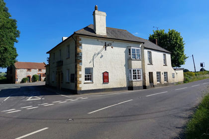
- Price
- £295,000
- Size
- 0.7 acres
Yeovil Road, Marston Magna, Yeovil, Somerset, BA22, , Somerset BA22 England
Added on 12/07/2026Pub
- Price
- Guide Price£280,000
- Size
- 0.05 acres
Added on 13/06/2026Warehouse