
Old Manse Croft, Drumoak, Banchory, AB31
- Land size
- 24 acres
- Bedrooms
- 3
Key Features
- Secluded riverside property with tennis court on one of Scotland's prime Salmon Rivers
- Well positioned for community to Aberdeen City and Westhill
- Well maintained fields with options for grazing or rewilding
- Ample outbuildings for diversification
Description
Old Manse Croft
A floor plan is provided at the rear of the brochure, however Old Manse Croft can be summarised as follows:
Ground Floor
Entrance hall / downstairs bathroom / double bedroom / sitting room / conservatory / kitchen / utility room
First Floor
Two double bedrooms / ensuite / dressing room / balcony
Overview
There are a choice of entry points into Old Manse Croft, with options to head straight into the house via the welcoming entrance hall, or opt to enter via the utility room to peel off muddy boots and wash up. There is also the option to take access from the garden via the conservatory into the kitchen, especially lovely when finishing a morning riverside walk.
Upon entering the property on the ground floor you will find a spacious bathroom with toilet, shower, and spacious corner bath. There is a large double bedroom opposite the sitting room with views down to the river.
The kitchen, sitting room and conservatory are all linked with a sizeable wood burning stove located centrally to heat the open living space.
A pine staircase with carpeted floor leads upstairs where there are two spacious bedrooms, the master room complimented by a walk in dressing room and balcony with stunning views out over the tennis court to the fields beyond and River Dee below. The upstairs bathroom has jack and jill doors, accessible from the second bedroom but also the landing for use by the master bedroom.
Property Details
EPC:
Band F
Internal Floorspace:
164sqm
Windows & Doors:
Double glazed
Council Tax:
Band E
Heating:
Oil Boiler and Radiators
Services:
Water: Private Supply Electricity: Mains Sewage: Septic tank
Land
The total area of land at Old Manse Croft extends to 24 acres or thereby. The soils are part of the Podzols major soil group, and are formed by the Humus-iron podzols subgroup. The land is classified as Grade 3.2 per the Land Capability for Agriculture (partial cover) maps from the James Hutton Institute.
The ground is currently utilised as grazing for horses and has been set out to accommodate this with paddocks and shelters on site.
There are multiple opportunities to maximise the land here, with tree planting, complimenting the existing mixed species shelter belts, and small scale wilding projects entirely possible. Equally, given the acreage there is a real opportunity here to create a desirable smallholding and raise various livestock or animals if desired.
Garden
The garden at Old Manse Croft provides ample space for relaxation, with a large area of mown grassland and various mature fruit trees blossoming throughout the summer. There is a large area to the side of the house which provides a perfect opportunity to create a small walled garden and grow a range of vegetables for use. Given the grassland in place at present, any purchaser is only limited by their imagination and time in creating a gardening retreat!
Sporting
Fishing rights are owned by another party, permits can be sought from the Upper Drum and Lower Durris owners or via FishPal if there are available rods.
It is understood that the other sporting rights are to be sold with the property where owned.
Buildings
Buildings at Old Manse Croft comprise a variety of traditional steadings and byres that provide a multitude of potential uses for an interested purchaser.
Currently the steadings are used for storage purposes, a snooker hall, and as a livery / tack room, however alternative uses of the buildings can be explored with the local authority and Historic Environment Scotland. The 18th century bothy and former offices to the rear of the dwelling are category C-Listed (HES ref: LB3083 Old Manse Croft Dalmaik Outbuildings).
Note:
Prospective purchasers should note that unless their interest in the property is formally intimated to the selling agents following inspection, the agents cannot guarantee that notice of a closing date for offers will be advised and consequently the property may be sold without notice.
Anti Money Laundering Compliance:
In accordance with The Money Laundering, Terrorist Financing and Transfer of Funds (Information on the Payer) Regulations 2017, we are required to carry out checks and due diligence on property purchasers. If an offer has been accepted, the purchaser(s) will need to provide proof of identity, residence and proof of funds, as a minimum, prior to any transaction proceeding.
Offers:
Formal offers, in the acceptable Scottish form should be submitted, along with the relevant anti-money laundering paperwork in accordance with The Money Laundering, Terrorist Financing and Transfer of Funds (Information on the Payer) Regulations 2017, through a Scottish Solicitor, to the Selling Agent.
Servitude Rights, Burdens and Wayleaves:
The property is sold subject to and with the benefit of all servitude rights, including rights of access and rights of way, whether public or private. The buyer(s) will be held to have satisfied himself/themselves as to the nature of all such servitude rights and others.
Title:
The buyer(s) shall be bound to accept the title as it presently stands in the name of the seller(s) and the conveyance in favour of the buyer(s) shall be subject to all the exceptions, reservations, burdens and conditions presently contained in the title deeds. There shall be excepted from warrandice in the conveyance in favour of the buyer(s) any leases, tenancies, tenants' rights, missives, agreements, rights of possession, rights of way, access rights, and sewerage and drainage facilities, and all other servitudes and other rights without prejudice to the right of the buyer(s) to quarrel or impugn the same on any ground not inferring warrandice against the seller(s).
Map Location
Property details
- Tenure
- Ask Agent
- Council Tax Band
- Ask Agent
- Date Posted
- 2026-07-17
Market Value Analysis
Compared with 71 Homes with Land listings in Scotland (10+ acres).
Utilities & Restrictions
Utilities
- Electricity
- Ask Agent
- Water
- Ask Agent
- Heating
- Ask Agent
- Broadband
- Ask Agent
- Sewerage
- Ask Agent
Rights & Restrictions
- Public Rights of Way
- Ask Agent
- Private Rights of Way
- Ask Agent
- Listed Property
- Ask Agent
- Restrictions
- Ask Agent
Listed status, conservation areas and planning constraints for this location are in the full report.
Property Features
- Accessibility
- Ask Agent
- Parking
- Ask Agent
- Garden
- Garden
Beyond the particulars: planning activity, flood history, heritage and ground risks, checked for this exact spot.
Connectivity
Broadband
Fastest speed available at this postcode
26 Mbps
Standard (10-30 Mbps)
Suitable for
- Web & social
- Music streaming
- Standard video calls
Mobile signal
Predicted 4G and 5G signal; indoor signal depends on building materials.
Ofcom Connected Nations postcode-level predictions. Speeds and signal are modelled, not measured, and vary between addresses and providers.
Signal is the easy part. Planning activity, flood history and protected designations here are in the full report.
Nearest Schools
Primary
- Drumoak School1.5 miles
- Pupils
- 131
- Type
- Non-denominational
- Culter School2.2 miles
- Pupils
- 283
- Type
- Non-denominational
- Durris School2.3 miles
- Pupils
- 43
- Type
- Non-denominational
- Lairhillock School3.3 miles
- Pupils
- 128
- Type
- Non-denominational
- Milltimber School3.8 miles
- Pupils
- 310
- Type
- Non-denominational
Secondary
- Cults Academy5.3 miles
- Pupils
- 1,275
- Type
- Non-denominational
- Westhill Academy5.5 miles
- Pupils
- 847
- Type
- Non-denominational
- Portlethen Academy6.7 miles
- Pupils
- 944
- Type
- Non-denominational
- Hazlehead Academy6.7 miles
- Pupils
- 1,074
- Type
- Non-denominational
- Banchory Academy7.1 miles
- Pupils
- 865
- Type
- Non-denominational
Distances are straight-line from the advertised location. Source: the national school registers (DfE, Welsh Government, Scottish Government) and Ofsted.
Schools are just the start: planning activity, heritage and any flood history here are in the full report.
Amenities
Supermarket
GP surgery
Pharmacy
Walking trail
Straight-line distances from the advertised location. Sources: NHS records, Geolytix supermarket locations, OS Open Greenspace and the national trails registers.
The area stacks up? Now check the location itself: planning nearby, protected designations and past flooding.
Getting Around
Nearest station
Nearest bus stop
Typical drive times
Straight-line distances from the advertised location; drive times are typical free-flow times over OpenStreetMap road data, so allow more at peak. Public transport locations from DfT NaPTAN.
Easy to reach matters. So do planning activity, flood history and ground risks: all in the full report.
Flood Risk
SEPA open data, checked around the advertised map pin for the listed acreage. Provided by LandSale, not the listing agent, and not part of the agent's particulars. Risk varies across a holding, so verify before committing.
Rivers and the sea
Surface water
Not at the pin: mapped about 30 metres away.
These bandings are the summary. Where this location sits on the flood maps, plus planning activity, heritage and ground risks, is in the full report.
Important notice: Information, maps and tags on this page are drawn from the advertising agent's marketing materials or generated automatically. LandSale has not verified them. Relying on these details is at your own risk, always carry out independent checks before committing to a purchase.
LandSale full disclaimer
Marketing information only - not formal particulars. The details on this website are provided for general guidance and do not constitute an offer or contract. Neither LandSale nor the advertising estate/land agent accepts responsibility for any inaccuracy.
1. Source of information
- Listing content: Core description, asking price, tenure, measurements, photographs and planning history originate from the marketing materials of the advertising estate or land agent. LandSale does not author this content and cannot guarantee its accuracy.
- Automated tags & categorisation: Property type, land-use class, acreage bands and similar labels may be applied by machine-learning models. They are intended as a helpful guide only and may not reflect the property's legal status or permitted use.
- Third-party & enriched data layers: Maps, boundary outlines, planning designations, soil reports, broadband coverage and other environmental or location-based insights are licensed from external suppliers. Such data are supplied “as is", may be incomplete or out of date and are subject to change without notice.
2. Verification required
Prospective purchasers must verify critical matters, including but not limited to planning permission, title boundaries, public rights of way, environmental constraints, acreage, services, access and VAT status, through their own inspections, specialist surveys, legal advisers and the selling agent before relying on the information or entering into any contract.
3. No warranty or liability
LandSale gives no warranty, express or implied, as to the accuracy, completeness or fitness for any particular purpose of the information displayed. LandSale shall not be liable for any loss, damage, cost or expense arising directly or indirectly from any use of or reliance on such information, save where liability may not be excluded by law.
4. Updates & feedback
If you believe any detail on this listing is inaccurate, please let us know. We will investigate and, where appropriate, update the listing or notify the agent.
© LandSale | Version 1.3 - August 2026
Listing agent
Aberdeen & Northern (Estates) Ltd, InverurieThainstone Agricultural Centre, Inverurie, AB51 5XZ
View agent profileSimilar properties for sale
- Price
- Offers Over£670,000
- Size
- 25 acres
Mill House, Strachan, Banchory, AB31, West Aberdeenshire and Kincardine, Aberdeenshire AB31 Scotland
Added on 02/07/2026House with Land
- Price
- Offers Over£499,000
- Size
- 2.3 acres
Added on 29/01/2026House with Land
- Price
- Offers Over£440,000
- Size
- 1.68 acres
Kinneff, Montrose, DD10, West Aberdeenshire and Kincardine, Aberdeenshire DD10 Scotland
Added on 29/01/2026Equestrian property
- Price
- Offers in Excess of£470,000
- Size
- 4 acres
Tough, Alford, AB33, West Aberdeenshire and Kincardine, Aberdeenshire AB33 Scotland
Added on 03/05/2026Cottage
- Price
- Offers Over£450,000
- Size
- 4.45 acres
Added on 14/10/2026Smallholding
- Price
- Offers in Excess of£555,000
- Size
- 20 acres
Newburgh, Ellon, AB41, Gordon and Buchan, Aberdeenshire AB41 Scotland
Added on 24/08/2026House with Land
- Price
- Offers Over£390,000
- Size
- 4 acres
Clatt, Huntly, AB54, Gordon and Buchan, Aberdeenshire AB54 Scotland
Added on 29/09/2026House with Land
- Price
- Offers Over£390,000
- Size
- 33.3 acres
2 Hayhillock Cottage, Ellon, Aberdeenshire, AB41, Gordon and Buchan, Aberdeenshire AB41 Scotland
Added on 13/10/2026Smallholding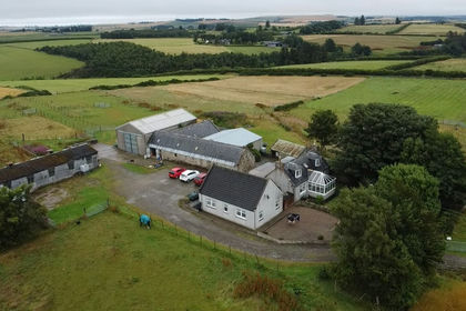
- Price
- Offers Over£380,000
- Size
- 10 acres
Cottown Croft, Gight, Methlick, AB41, Gordon and Buchan, Aberdeenshire AB41 Scotland
Added on 10/08/2026House with Land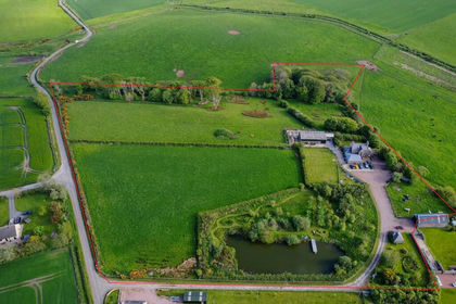
- Price
- Offers Over£599,995
- Size
- 11 acres
Hatton, Peterhead, AB42, Aberdeenshire North and Moray East, Aberdeenshire AB42 Scotland
Added on 16/06/2026House with Land