Jackson Road, Newbourne
- Land size
- 2.25 acres
- Bedrooms
- 5
- Bathrooms
- 2
Key Features
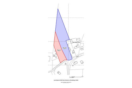
- GROUNDS OF APPROX 2.25 ACRES SUBJECT TO SURVEY
- FIVE BEDROOMS
- POTENTIAL FOR BUILDING PLOT SUBJECT TO PLANNING CONSENT
- SUFFOLK COUNTRYSIDE
- NO ONWARD CHAIN
- SUBJECT TO GRANT OF PROBATE
- POPULAR LOCAL PUB AND RESTAURANT THE FOX
- EPC RATING D
Description
A five bedroom detached house measuring approximately 2251 square feet, set in grounds of 2.25 acres (STS), originally built in the 1930's as part of the Land Settlement Scheme and since, significantly extended with two storey extensions on both north and south elevations with a Mansard roof design.
Heating is supplied in the form of oil fired central heating, windows are made up of UPVC double glazed units and the property is connected to mains water and electricity and there is a private Cesspit on the property for surface water and drainage.
The property is offered for sale with vacant possession, no onward chain and subject to the grant of probate, which has been submitted and is pending approval. There is great scope with the property for improvement and a rare opportunity for the successful purchaser to put their own stamp on the property by redesigning the existing house to create a contemporary home in the picturesque Suffolk Countryside.
THE AREA Newbourne is a small village and civil parish in the county of Suffolk, England. It lies on the peninsula between the Rivers Orwell and Deben, 8.5 miles east of Ipswich and 5 miles south of Woodbridge.
The name Newbourne is commonly accepted to derive from the Old English words for 'new stream.' However, it has also been put forward that its origins may be from the Old Norse words for 'nine springs,' which is supported by the large number of nearby springs and other villages in the local area with names of Old Norse origin.
The Land Settlement Association was set up in 1934 as an experimental scheme to provide unemployed workers from depressed industrial areas with employment on the land. Successful applicants received agricultural training and each family was given on average 5 acres and livestock to rear. Recruitment into the scheme ended with the start of World War Two and eventually the settlements were dissolved and privatised in 1983. Newbourne was one of the areas involved in the scheme and its legacy can still be seen in the large number of commercial greenhouses, plant nurseries and roadside produce stalls remaining in the village and local area. There are still a small number of "growers" left the largest is Virginia Nurseries.
Newbourne Springs is a small nature reserve and Site of Special Scientific Interest SSSI on the edge of the village. It is composed of a range of habitats, primarily broadleaved and mixed woodland with some areas of marsh, fen and heathland. It is currently managed by Suffolk Wildlife Trust on behalf of Anglian Water who own the land. Due to the large number of springs within its area it was used as a source of water for Felixstowe and the surrounding area by Anglian Water until the 1980s. Today the old pumping station has been converted into a visitors centre for the reserve. During autumn and winter months regular volunteer working parties help with maintenance of the reserve. A number of public footpaths run from the village through Newbourne Springs.
ACCOMMODATION WITH APPROXIMATE ROOM SIZES
UPVC DOUBLE GLAZED ENTRANCE DOOR TO:-
ENTRANCE HALL 12' 5" x 10' 10" (3.78m x 3.3m)
LOUNGE 22' 2" x 14' 10" (6.76m x 4.52m)
KITCHEN/BREAKFAST ROOM 18' 8" x 9' 3" (5.69m x 2.82m)
DINING ROOM 14' 1" x 13' 2" (4.29m x 4.01m)
SEPARATE GROUND FLOOR WC
BATHROOM
STORE
CONSERVATORY 11' 7" x 8' 7" (3.53m x 2.62m)
FIRST FLOOR ACCOMMODATION
LANDING
BEDROOM 1 20' 5" x 11' 2" (6.22m x 3.4m)
BEDROOM 2 14' 11" x 9' 11" (4.55m x 3.02m)
BEDROOM 3 12' 00" x 10' 00" (3.66m x 3.05m)
BEDROOM 4 10' 00" x 9' 00" (3.05m x 2.74m)
FIRST FLOOR BATHROOM
BEDROOM 5 8' 10" x 6' 5" (2.69m x 1.96m)
COUNCIL TAX BAND Band E.
ENERGY PERFORMANCE CERTIFICATE The current energy efficiency rating is D (57) with a potential rating of C (69) and the current energy performance certificate is valid until 12th July 2035.
IMPORTANT NOTE The property is offered for sale with vacant possession, no onward chain and subject to the grant of probate, which has been submitted and is pending approval.
PRIVATE ROAD Jackson Road is a private road. All residents pay £20 per year for insurance and a committee arranges any repairs as needed and all costs are shared. This property owns the road directly in front of house.
Map Location
Property details
- Tenure
- Freehold
- Council Tax Band
- Ask Agent
- Date Posted
- 2026-07-03
Market Value Analysis
Compared with 1,131 Homes with Land listings in East Anglia (1+ acres).
Energy Performance Certificate
View the official EPC certificate for detailed energy efficiency information.
Utilities & Restrictions
Utilities
- Electricity
- Ask Agent
- Water
- Ask Agent
- Heating
- Ask Agent
- Broadband
- Ask Agent
- Sewerage
- Ask Agent
Rights & Restrictions
- Public Rights of Way
- Ask Agent
- Private Rights of Way
- Ask Agent
- Listed Property
- Ask Agent
- Restrictions
- Ask Agent
Property Features
- Accessibility
- Ask Agent
- Parking
- Ask Agent
- Garden
- Garden
Connectivity
Broadband
Fastest speed available at this postcode
5.5 Gbps
Gigabit full fibre · available to 12% of premises
Suitable for
- 4K streaming on every screen
- Full-time home working
- Online gaming & big downloads
Mobile signal
Outdoor predictions; indoor signal depends on building materials.
Ofcom Connected Nations postcode-level predictions. Speeds and signal are modelled, not measured, and vary between addresses and providers.
Nearest Schools
Primary
- Bucklesham Primary School1 mileOfsted: Good
- Ages
- 4 to 11
- Pupils
- 104
- Type
- Community school
- Waldringfield Primary School1.5 milesOfsted: Requires improvement
- Ages
- 3 to 11
- Pupils
- 69
- Type
- Academy converter
- Birchwood Primary School2.3 milesNo Ofsted rating
- Ages
- 4 to 11
- Pupils
- 209
- Type
- Community school
- Trimley St Martin Primary School2.4 milesNo Ofsted rating
- Ages
- 4 to 11
- Pupils
- 168
- Type
- Community school
- Gorseland Primary School2.7 milesOfsted report card · Dec 2025
- Ages
- 3 to 11
- Pupils
- 461
- Type
- Community school
Secondary
- Kesgrave High School3.4 milesOfsted: Good
- Ages
- 11 to 18
- Pupils
- 1,875
- Type
- Academy converter
- Felixstowe School4.4 milesOfsted: Good
- Ages
- 11 to 19
- Pupils
- 1,169
- Type
- Academy sponsor led
- Farlingaye High School4.7 milesOfsted report card · May 2026
- Ages
- 11 to 18
- Pupils
- 1,861
- Type
- Academy converter
- St Alban's Catholic High School4.8 milesOfsted: Good
- Ages
- 11 to 18
- Pupils
- 967
- Type
- Academy converter
- Faith
- Roman Catholic
- Copleston High School4.8 milesNo Ofsted rating
- Ages
- 11 to 18
- Pupils
- 1,930
- Type
- Academy converter
Distances are straight-line from the advertised location. Source: the national school registers (DfE, Welsh Government, Scottish Government) and Ofsted.
Amenities
Supermarket
GP surgery
Pharmacy
Hospital
Straight-line distances from the advertised location. Sources: NHS records, Geolytix supermarket locations, OS Open Greenspace and the national trails registers.
Getting Around
Nearest station
Nearest bus stop
Typical drive times
Straight-line distances from the advertised location; drive times are typical free-flow times over OpenStreetMap road data, so allow more at peak. Public transport locations from DfT NaPTAN.
Flood Risk
From Environment Agency flood map open data, checked around the advertised map pin and allowing for the listed acreage where known. This summary comes from LandSale, the advertising platform, not from the listing agent, and is not part of the agent's particulars. Risk can vary across a single holding, so verify anything critical through your own searches before committing.
Rivers and the sea
Surface water
The detail behind these bandings, including exact zones and annual chances, any recorded past flooding, plus planning, heritage, nature and ground checks, is in the .
Important notice: Information, maps and tags on this page are supplied by the advertising agent or generated automatically. LandSale has not verified them. Relying on these details is at your own risk, always carry out independent checks before committing to a purchase.
LandSale full disclaimer
Marketing information only - not formal particulars. The details on this website are provided for general guidance and do not constitute an offer or contract. Neither LandSale nor the advertising estate/land agent accepts responsibility for any inaccuracy.
1. Source of information
- Agent-supplied content: Core description, asking price, tenure, measurements, photographs and planning history are uploaded by the appointed agent, who remains solely responsible for their accuracy.
- Automated tags & categorisation: Property type, land-use class, acreage bands and similar labels may be applied by machine-learning models. They are intended as a helpful guide only and may not reflect the property's legal status or permitted use.
- Third-party & enriched data layers: Maps, boundary outlines, planning designations, soil reports, broadband coverage and other environmental or location-based insights are licensed from external suppliers. Such data are supplied “as is", may be incomplete or out of date and are subject to change without notice.
2. Verification required
Prospective purchasers must verify critical matters, including but not limited to planning permission, title boundaries, public rights of way, environmental constraints, acreage, services, access and VAT status, through their own inspections, specialist surveys, legal advisers and the selling agent before relying on the information or entering into any contract.
3. No warranty or liability
LandSale gives no warranty, express or implied, as to the accuracy, completeness or fitness for any particular purpose of the information displayed. LandSale shall not be liable for any loss, damage, cost or expense arising directly or indirectly from any use of or reliance on such information, save where liability may not be excluded by law.
4. Updates & feedback
If you believe any detail on this listing is inaccurate, please let us know. We will investigate and, where appropriate, update the listing or notify the agent.
© LandSale | Version 1.2 - January 2026
Listing agent
Diamond Mills & Co, Felixstowe
117 Hamilton Road, Felixstowe, IP11 7BL
View agent profileSimilar properties for sale
- Price
- Guide Price£750,000
- Size
- 2 acres
Added on 14/08/2026Building Plot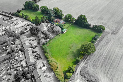
- Price
- £600,000
- Size
- 1.8 acres
Lings Lane, Chelmondiston, Suffolk, Chelmondiston, Suffolk IP9 England
Added on 23/07/2026Multiple Dwelling Property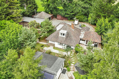
- Price
- £750,000
- Size
- 1.25 acres
Sheepdrift Road, Bromeswell, Woodbridge, Bromeswell, Suffolk IP12 England
Added on 18/06/2026House with Land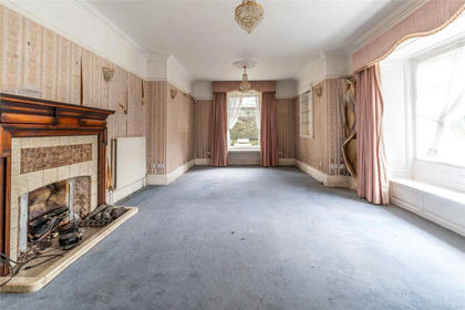
- Price
- Offers in Region of£725,000
- Size
- 1 acres
Westerfield, Ipswich, Suffolk, IP6, Westerfield, Suffolk IP6 England
Added on 04/02/2026House with Land
- Price
- Guide Price£625,000
- Size
- 12.79 acres
Added on 23/05/2026House with Land
- Price
- Offers Over£600,000
- Size
- 3 acres
Added on 18/04/2026Cottage
- Price
- £800,000
- Size
- 1 acres
Added on 10/05/2026House with Land
- Price
- £750,000
- Size
- 1.71 acres
Harwich Road, Great Oakley, Great Oakley, Essex CO12 England
Added on 28/04/2026Equestrian property
- Price
- Guide Price£650,000
- Size
- 6.5 acres
Easton, Near Framlingham, Suffolk, Easton, Suffolk IP13 England
Added on 29/01/2026House with Land
- Price
- Offers in Excess of£800,000
- Size
- 1.25 acres
Bluegate Farm, Bluegate Lane, Capel St Mary IP9, Capel St. Mary, Suffolk IP9 England
Added on 29/01/2026Property with Annexe