Rugby Road, South Kilworth, LE17
- Bedrooms
- 2
- Bathrooms
- 1
Key Features
- Detached barn conversion
- Two bedrooms
- Private gated mews
- Fitted kitchen diner
- Large sitting room with feature fireplace
- Private landscaped rear garden
- Parking
- Edge of village location
Description
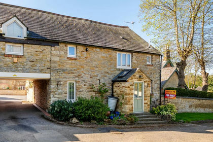
Freshfields Barn, a delightful two bedroom barn conversion located in a secure private gated mews situated on the edge of the South Leicestershire village of South Kilworth.
The accommodation comprises entrance hall, kitchen diner, large sitting room with a feature fireplace and patio doors leading out to the private landscaped rear garden. Further accommodation comprises two bedrooms and a bathroom.
Out side the property is approached through electric gates leading to private parking and a raised front patio area giving magnificent countryside view over the surrounding countryside. To the rear of the property is a private landscaped garden, mainly laid to lawn with mature borders and a patio area.
South Kilworth is a village in central England, a region referred to as the East Midlands. It is situated towards the southernmost extremity of Leicestershire being only a half hour drive from Leicester’s city centre. It is in the LE17 postcode district and is a civil parish. It falls within the district council of Harborough and is within easy reach of larger towns such as Lutterworth, Market Harborough and Rugby, all providing a variety of amenities such as edge of town super stores or uniquely bespoke shops.
Essentially, South Kilworth is geographically at the centre of an intersection of transportation routes. The North Road takes you to North Kilworth and heading south on the Kilworth Road will lead to Welford. Heading south-west or north-west, will incur meeting the M1 at junctions 19 and 20, Rugby and Lutterworth respectively. From those points the M6 and M69 maximise the potential for speedier travel by road from this central Midland location.
There are two railway stations within easy reach, at Rugby and Market Harborough, with regular high speed trains to London Euston and St. Pancras taking typically less than one hour. The nearest airports are Birmingham, East Midlands and Coventry. London Luton is 60 miles away by car.
In times past, the Domesday Book of 1086 records a settlement known then as Cleveliord which many believe is referring to South Kilworth as it could mean hedged enclosure. There have been settlements in the vicinity since prehistoric times with later evidence pertaining to Roman, Anglo Saxon and mediaeval periods. The village was certainly established before the Norman Conquest, with a manor and farming community. There remains evidence of forridge and furrow cultivation in fields bordering the village. The church of St Nicholas is twelfth century in part but holds a clock tower installed as a memorial to the men of the locality who died fighting in the 1914-18 war. There are a number of historic houses in the village along the Welford and Walcote Roads dating from the fifteenth and sixteenth centuries.
Today, the village hall is the centre for many social activities, events and clubs. It has extensive sports pitches, a children’s playground, adult fitness equipment and a bowling green. As with many communities, people are interested to share points of communal interest and the South Kilworth monthly newsletter will be a good starting point for those new to the area. An excellent village website produced by the parish council also contains a wealth of information.
There are several public houses and restaurants in or close by to South Kilworth: The White Hart, The Attic, White Lion or Black Horse to name a few. These serve locally produced food and ales. There is easy access to wider open spaces, with nature reserves and bridal paths within easy reach. Kilworth Springs Golf Club, Kilworth House Hotel and the Outdoor Theatre attract people to the vicinity, as does the North Kilworth Marina. Golf courses and equestrian centres are easily reached by car.
There is a local primary school, South Kilworth Primary School but over a wider area there are several educational options; nursery, primary and secondary. South Kilworth is in the catchment area for the Rugby (Warwickshire) Grammar Schools. Other schools include the Rugby School, Leicester Grammar, Princethorpe and Oakham. There are also private establishments in the county offering bordering facilities. The Office for Standards in Education - OFSTED – is best researched to provide a comprehensive review of currently rated standards of practice.
Disclaimer
Important Information:
Property Particulars: Although we endeavor to ensure the accuracy of property details we have not tested any services, equipment or fixtures and fittings. We give no guarantees that they are connected, in working order or fit for purpose.
Floor Plans: Please note a floor plan is intended to show the relationship between rooms and does not reflect exact dimensions. Floor plans are produced for guidance only and are not to scale.
Map Location
Property details
- Tenure
- Freehold
- Council Tax Band
- Ask Agent
- Date Posted
- 2026-07-02
Energy Performance Certificate
Energy Efficiency Rating
Based on UK Energy Performance Certificate standards (EU Directive 2002/91/EC)
Utilities & Restrictions
Utilities
- Electricity
- Ask Agent
- Water
- Ask Agent
- Heating
- Ask Agent
- Broadband
- Ask Agent
- Sewerage
- Ask Agent
Rights & Restrictions
- Public Rights of Way
- Ask Agent
- Private Rights of Way
- Ask Agent
- Listed Property
- Ask Agent
- Restrictions
- Ask Agent
Property Features
- Accessibility
- Ask Agent
- Parking
- Parking Available
- Garden
- Garden
Connectivity
Broadband
Fastest speed available at this postcode
1 Gbps
Gigabit full fibre · available to 85% of premises
Suitable for
- 4K streaming on every screen
- Full-time home working
- Online gaming & big downloads
Mobile signal
Outdoor predictions; indoor signal depends on building materials.
Ofcom Connected Nations postcode-level predictions. Speeds and signal are modelled, not measured, and vary between addresses and providers.
Nearest Schools
Primary
- South Kilworth Church of England Primary School304 metresOfsted: Good
- Ages
- 4 to 11
- Pupils
- 70
- Type
- Academy converter
- Faith
- Church of England
- St Andrew's Church of England Primary School, North Kilworth1.1 milesNo Ofsted rating
- Ages
- 3 to 11
- Pupils
- 107
- Type
- Academy converter
- Faith
- Church of England
- Welford Sibbertoft and Sulby Endowed School2.4 milesOfsted report card · Mar 2026
- Ages
- 4 to 11
- Pupils
- 98
- Type
- Academy converter
- Faith
- Church of England
- Swinford Church of England Primary School2.6 milesNo Ofsted rating
- Ages
- 4 to 11
- Pupils
- 101
- Type
- Academy converter
- Faith
- Church of England
- Husbands Bosworth Church of England Primary School2.8 milesNo Ofsted rating
- Ages
- 5 to 11
- Pupils
- 93
- Type
- Academy converter
- Faith
- Church of England
Secondary
- Lutterworth High School4.4 milesOfsted: Good
- Ages
- 11 to 16
- Pupils
- 849
- Type
- Academy converter
- Lutterworth College4.6 milesNo Ofsted rating
- Ages
- 11 to 19
- Pupils
- 1,580
- Type
- Academy converter
- Faith
- Church of England
- Houlton School5.5 milesOfsted: Good
- Ages
- 11 to 18
- Pupils
- 895
- Type
- Free schools
- Guilsborough Academy6.5 milesOfsted: Requires improvement
- Ages
- 11 to 18
- Pupils
- 1,198
- Type
- Academy converter
- Ashlawn School7.1 milesOfsted: Good *
- Ages
- 11 to 18
- Pupils
- 1,564
- Type
- Academy converter
* Latest graded judgement covers quality of education only; no overall grade was issued under the 2024-25 inspection framework.
Distances are straight-line from the advertised location. Source: the national school registers (DfE, Welsh Government, Scottish Government) and Ofsted.
Amenities
Supermarket
GP surgery
Pharmacy
Hospital
Green space
Straight-line distances from the advertised location. Sources: NHS records, Geolytix supermarket locations, OS Open Greenspace and the national trails registers.
Getting Around
Nearest station
Nearest bus stop
Typical drive times
Straight-line distances from the advertised location; drive times are typical free-flow times over OpenStreetMap road data, so allow more at peak. Public transport locations from DfT NaPTAN.
Flood Risk
From Environment Agency flood map open data, checked around the advertised map pin and allowing for the listed acreage where known. This summary comes from LandSale, the advertising platform, not from the listing agent, and is not part of the agent's particulars. Risk can vary across a single holding, so verify anything critical through your own searches before committing.
Rivers and the sea
Surface water
The detail behind these bandings, including exact zones and annual chances, any recorded past flooding, plus planning, heritage, nature and ground checks, is in the .
Important notice: Information, maps and tags on this page are supplied by the advertising agent or generated automatically. LandSale has not verified them. Relying on these details is at your own risk, always carry out independent checks before committing to a purchase.
LandSale full disclaimer
Marketing information only - not formal particulars. The details on this website are provided for general guidance and do not constitute an offer or contract. Neither LandSale nor the advertising estate/land agent accepts responsibility for any inaccuracy.
1. Source of information
- Agent-supplied content: Core description, asking price, tenure, measurements, photographs and planning history are uploaded by the appointed agent, who remains solely responsible for their accuracy.
- Automated tags & categorisation: Property type, land-use class, acreage bands and similar labels may be applied by machine-learning models. They are intended as a helpful guide only and may not reflect the property's legal status or permitted use.
- Third-party & enriched data layers: Maps, boundary outlines, planning designations, soil reports, broadband coverage and other environmental or location-based insights are licensed from external suppliers. Such data are supplied “as is", may be incomplete or out of date and are subject to change without notice.
2. Verification required
Prospective purchasers must verify critical matters, including but not limited to planning permission, title boundaries, public rights of way, environmental constraints, acreage, services, access and VAT status, through their own inspections, specialist surveys, legal advisers and the selling agent before relying on the information or entering into any contract.
3. No warranty or liability
LandSale gives no warranty, express or implied, as to the accuracy, completeness or fitness for any particular purpose of the information displayed. LandSale shall not be liable for any loss, damage, cost or expense arising directly or indirectly from any use of or reliance on such information, save where liability may not be excluded by law.
4. Updates & feedback
If you believe any detail on this listing is inaccurate, please let us know. We will investigate and, where appropriate, update the listing or notify the agent.
© LandSale | Version 1.2 - January 2026
Listing agent
Fine and Country Leicester, Leicester
40 The Parade, Oadby, Leicester, LE2 5BF
Contact Fine and Country Leicester, Leicester
40 The Parade, Oadby, Leicester, LE2 5BF
View agent profileSimilar properties for sale
- Price
- Guide Price£300,000
- Size
- 0.2 acres
Added on 15/04/2026Self Build Plot
- Price
- Guide Price£425,000
Glen Rise, Great Glen, LE2, Great Glen, Leicestershire LE2 England
Added on 20/03/2026Self Build Plot
- Price
- Guide Price£300,000
121 B, High Street, Earl Shilton, Earl Shilton, Leicestershire LE9 England
Added on 21/07/2026Barn Conversion
- Price
- Guide Price£440,000
Added on 17/06/2026Development Land
- Price
- Guide Price£425,000
Church Street, Billesdon, Billesdon, Leicestershire LE7 England
Added on 13/06/2026Barn Conversion
- Price
- Offers in Region of£350,000
Added on 29/01/2026Building Plot
- Price
- Offers in Region of£350,000
The Promenade, Wellingborough, Wellingborough, North Northamptonshire NN8 England
Added on 08/04/2026Building Plot Added on 29/01/2026Development Land
 Added on 21/02/2026Barn Conversion
 Added on 29/01/2026Barn Conversion