Land off Thistleton Road, Thistleton, LE15 7RQ
- Land size
- 92.17 acres
Description
An exciting opportunity to purchase approximately 92.16 acres (37.30 ha) of arableland to the west of the village of Thistleton, Rutland. The land is divided into two blocks to the north and south of Thistleton Road.
Lotting - The land is available as a whole or in two separate lots.
Lot 1 - Lot 1 extends to 78.82 acres (31.90 hectares) or thereabouts of predominetly arable land and according to the Agricultural Land Classification Map the land is Grade 3 (being good to moderate). Soilscapes defines the soil type as being part: Soilscape 3: Shallow lime-rich soils over chalk or limestone and Soilscapes 18: Slowly permeable seasonally wet slightly acid but base-rich loamy and clayey soils. The land is split into five seperate enclosures surrounded by mature hedges and is relatively flat lying with gentle undulations. A small area of mature woodland is located to the southern part of the lot extending to approximately 4.75 acres. A small timber frame barn is located within a small yard area to halfway down access track.
Lot 2 - Lot 2 extends to 13.36 acres (5.41 hectares) or thereabouts of predominantly arable land and according to the Agricultural Land Classification Map the land is Grade 3 (being good to moderate). Soilscapes defines the soil type as being part: Soilscape 3: Shallow lime-rich soils over chalk or limestone and Soilscapes 18: Slowly permeable seasonally wet slightly acid but base-rich loamy and clayey soils. The land comprises of a single field of relatively flat with gentle undulations and a small area of woodland located to the north east corner of the lot.
Location - The land parcel is accessed off Thistleton Road, on the edge of the village of Thistleton. Thistleton is approximately 7 miles to the North East of the Town of Oakham and approximately 10 miles to the East of the Market town of Stamford.
The land will be clearly identifiable by our 'For Sale' board at the gateway.
What3Words:///parkway.hurricane.ticket
Guide Price - As a whole 92.17 acres – Guide Price £950,000
Lot 1: 78.82 acres (red) - Guide Price of £800,000
Lot 2: 13.36 acres (blue) - Guide Price of £150,000
Method Of Sale - Offers are to be submitted in writing by 12 noon on Friday 7th August 2026.
Offers should include the following information:
1.All offers are to be expressed in pounds sterling
2.Offers should not be made by reference to any other offers
3.Offers should state whether offers are for cash or dependent on borrowing/funding.
4.The vendors and selling agents advise all offers be received via email to the following email address james. – a confirmation of receipt will be sent.
Tenure - The land is let on an Agricultural Holding Act tenancy with vacant possession available from 10th October 2026.
Local Authority - Rutland County Council
Catmose
Oakham
LE15 6HP
Sporting, Timber & Mineral Rights - All sporting, timber and mineral rights, where owned, are included in the sale.
Wayleaves, Easements And Rights Of Way - The agents are not aware of any rights of way, wayleaves or easements across the land.
However, the property is sold subject to any other wayleaves, public or private rights of way, easements, covenants and all outgoings, whether mentioned in the sales particulars or not.
Flood Zone - All of the land is located within Flood Zone 1 (Low Probability).
Services - The land does not benefit from any mains services.
Development Uplift Clause - The property will be sold subject to a development uplift clause whereby 30% of any increase in value arising from development, implementation or the sale with the benefit of planning consent (excluding uses for agriculture and personal equestrian purposes), will be payable to the vendor for a period of 50 years from the date of completion.
Environmental Schemes - The agent is not aware that the land is subject to any environmental schemes.
Land Registry - The land is registered with the Land Registry and is title number LT420714.
Vat - In the event that any part of the land is subject to VAT, this will be payable by the purchaser in addition to the purchase price.
Rates And Other Outgoings - The property is sold subject to any other rates and outgoings which the purchaser will be liable for.
Viewings - The land may be viewed by prior appointment with the Selling Agent. Please contact us to arrange a viewing.
Plan - The plan with red lines are based on Ordnance Survey data and provided for reference purposes only. The vendor not the Vendor's agent are responsible for defining the boundaries or the ownership.
Further Information - For any further information, please contact James Holgate BSc (Hons)
Tel:
Email: james.
Map Location
Property details
- Tenure
- Freehold
- Council Tax Band
- Ask Agent
- Date Posted
- 2026-06-27
Market Value Analysis
Based on land listings in East Midlands (75+ acres).
Utilities & Restrictions
Utilities
- Electricity
- Ask Agent
- Water
- Ask Agent
- Heating
- Ask Agent
- Broadband
- Ask Agent
- Sewerage
- Ask Agent
Rights & Restrictions
- Public Rights of Way
- Ask Agent
- Private Rights of Way
- Ask Agent
- Listed Property
- Ask Agent
- Restrictions
- Ask Agent
Property Features
- Accessibility
- Ask Agent
- Parking
- Ask Agent
- Garden
- Garden
Important notice: Information, maps and tags on this page are supplied by the advertising agent or generated automatically. LandSale has not verified them. Relying on these details is at your own risk, always carry out independent checks before committing to a purchase.
LandSale full disclaimer
Marketing information only - not formal particulars. The details on this website are provided for general guidance and do not constitute an offer or contract. Neither LandSale nor the advertising estate/land agent accepts responsibility for any inaccuracy.
1. Source of information
- Agent-supplied content: Core description, asking price, tenure, measurements, photographs and planning history are uploaded by the appointed agent, who remains solely responsible for their accuracy.
- Automated tags & categorisation: Property type, land-use class, acreage bands and similar labels may be applied by machine-learning models. They are intended as a helpful guide only and may not reflect the property's legal status or permitted use.
- Third-party & enriched data layers: Maps, boundary outlines, planning designations, soil reports, broadband coverage and other environmental or location-based insights are licensed from external suppliers. Such data are supplied “as is", may be incomplete or out of date and are subject to change without notice.
2. Verification required
Prospective purchasers must verify critical matters, including but not limited to planning permission, title boundaries, public rights of way, environmental constraints, acreage, services, access and VAT status, through their own inspections, specialist surveys, legal advisers and the selling agent before relying on the information or entering into any contract.
3. No warranty or liability
LandSale gives no warranty, express or implied, as to the accuracy, completeness or fitness for any particular purpose of the information displayed. LandSale shall not be liable for any loss, damage, cost or expense arising directly or indirectly from any use of or reliance on such information, save where liability may not be excluded by law.
4. Updates & feedback
If you believe any detail on this listing is inaccurate, please let us know. We will investigate and, where appropriate, update the listing or notify the agent.
© LandSale | Version 1.2 - January 2026
Listing agent
Andrew Granger & Co Rural, Land and Development, Loughborough
7-8 Bedford Square, Loughborough, LE11 2TP
Contact Andrew Granger & Co Rural, Land and Development, Loughborough
7-8 Bedford Square, Loughborough, LE11 2TP
View agent profileSimilar properties for sale

- Price
- Guide Price£770,000
- Size
- 82.65 acres
Added on 31/05/2026Farmland
- Price
- Guide Price£825,000
- Size
- 78.24 acres
Land at Bruntingthorpe Road, Shearsby, LE17 6PP, Shearsby, Leicestershire LE17 6PP England
Added on 10/05/2026Arable Land
- Price
- Guide Price£750,000
- Size
- 76.98 acres
Holme, Yaxley, Peterborough, Cambridgeshire, Holme, Cambridgeshire PE7 3PT England
Added on 26/05/2026Farm
- Price
- Guide Price£950,000
- Size
- 131.01 acres
Cadeby, Leicestershire, Newbold Verdon, Leicestershire LE9 9LE England
Added on 27/06/2026Farmland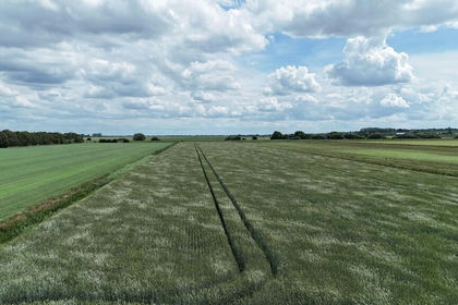
- Price
- Guide Price£895,000
- Size
- 119.33 acres
Added on 13/06/2026Farmland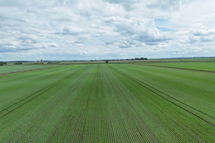
- Price
- Guide Price£930,000
- Size
- 124.44 acres
Added on 13/06/2026Farmland
- Price
- £900,000
- Size
- 71.98 acres
Manea Road, Wimblington, March, Wimblington, Cambridgeshire PE15 0PE England
Added on 29/01/2026Arable Land