Rose Farm, Shotley
- Land size
- 229 acres
- Bedrooms
- 4
- Bathrooms
- 2
Key Features
- Productive arable land and grassland.
- Four bedroom detached cottage
- Located within Suffolk Coast and Heath Area of Outstanding Natural Beauty
- Available as a whole or in three lots
Description
Summary
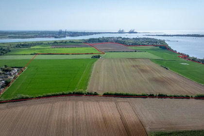
Approximately 229 acres of productive arable land and grassland, located in an attractive rural position on the Shotley peninsular between the Rivers Stour and River Orwell with direct access to the Coastal Path route and providing related river access.
Four-bedroom detached cottage in an elevated position overlooking the Rivers
Available as a whole or in three lots.
Location and Access
Rose Farm is situated in south Suffolk close to the village of Shotley. The property is bordered by the River Stour to the south and the River Orwell to the east.
The property sits approximately 9 miles south of the town of Ipswich and 21 miles to the north east of Colchester. The land is within the Suffolk Coast and Heath Area of Outstanding Natural Beauty.
Access to the property is directly off the B1456 highway.
The B1456 runs from Ipswich heading towards Shotley Gate. Details of access arrangements are available on request
Description
Lot One
Lot 1 extends to approximately 136.24 acres (55.13 hectares) of productive arable land immediately adjacent to the River Stour.
The soil is listed as the Ludford Soil Association and is further described as deep well drained fine loamy, coarse loamy and sandy soils locally flinty and in places over gravel suitable for growing potatoes, sugar beet, cereals, peas and beans.
A 5 year cropping rotation can be found later on in the particulars.
Lot Two - SOLD SUBJECT TO CONTRACT
Lot Three - Shotley Cottage
Shotley Cottage is a four-bedroom detached cottage extends to approximately 1,229sqft (114.2 sqm) in an elevated position with exceptional views over the surrounding Rivers.
The ground floor consists of a kitchen, two reception rooms and a downstairs bathroom and WC. The first floor comprises of four bedrooms and a shower room. A detailed floor plan is available through the selling agents. The Cottage is in need of modernisation throughout.
The cottage benefits from mains water and mains electricity, together with a private drainage system. The services have not been tested, and the buyer should satisfy themselves with the condition of such. The Cottage has an EPC rating of an F.
General Remarks
Tenure & Possession
The property is offered for sale freehold with vacant possession subject to the holdover provisions mentioned later in these details. The land is currently farmed under the terms of a Contract Farming Agreement and the current contractor would be pleased to continue this agreement with the incoming purchaser.
Method of Sale
The property is being offered for sale by Private Treaty as a whole or in three lots.
Lot One: 136.24ac
Lot Two: 92.53 ac
Lot Three: 0.24ac (including Shotley Cottage)
Vendors Solicitor
Howes Percival, 1 Bedding Land, Norwich, Norfolk NR3 1RG.
Wayleaves, Easements, Covenants & Rights Of Way
The land is sold subject to all existing rights of way, both public or private, drainage, water and electricity supplies and all other rights and obligations, easements, quasi easements and wayleaves whether referred to or not in the particulars.
Please note there is a restricted byway crossing Lot One from Rose Farm to the north heading south towards the River Stour. This track is also the access to the residential properties at Cockle Creek. If Lot Three is sold separately, the Purchaser will be granted a right of way from the north with emergency access only to the east.
There are also two public footpaths crossing lot one from west to east. There are two footpaths crossing lot two heading east to west on the northern and southern boundary. Further details of the public rights of way upon request from seller's agent.
Holdover
The Vendors reserve the right for their contractor to access and harvest the potato crop until 31 October 2025.
The Seller will also holdover on the stewardship land until 31 December 2025. Further details of the stewardship agreement are available from the selling agents.
Sporting, Mineral & Timber
Insofar as they are owned all sporting, minerals and timber rights are included in the sale. All such rights are believed to be owned by the Vendor.
Timing
It is intended that an exchange of contracts will take place within 28 days of the purchaser's solicitor receiving the draft contract. Completion will take place 28 days thereafter.
A 10% deposit will be payable on exchange of contracts.
Environmental Stewardship
The property is subject to a Countryside Stewardship Scheme which expires in December 2025. The Seller will retain holdover over this land which is subject to the stewardship until the agreement expires. Copies of the agreement are available from the selling agent.
Plans, Areas & Boundaries
The boundaries are based on the Ordnance Survey and areas for reference only. The Purchaser will be deemed to have full knowledge of all boundaries and any error or mistake shall not be the responsibility of the Vendor or entitle any party to compensation in respect thereof.
The Vendors will be required to fence the northern and eastern boundaries of lot 1 following the harvest of the 2025 crop if required. The line will be GPS surveyed by the Vendors and the specification will be agreed between the parties.
Land Registry
The property is registered Freehold within Part Title Numbers SK319146 and SK142279.
VAT
It is understood that VAT is not applicable to the sale. If VAT does become chargeable, it will be in addition to the sale price. Any guide price will be exclusive of VAT unless specified otherwise.
Planning & Local Authority
Babergh District Council - where details of the planning history and policies that affect the property can be found.
Viewing & Further Information
Strictly by appointment with the selling agent.
Health & Safety
Given the potential hazards and risks of a working farm we ask you to be as vigilant as possible for your own personal safety when viewing the property.
what3words
///grouping.uppermost.attracts - will locate Shotley Cottage.
Photographs
The photographs in these particulars were taken in May 2025
Anti Money Laundering
In accordance with the Money Laundering Regulations 2017, following the seller accepting an offer, the purchaser will be required to provide proof of identity and address prior to the instruction of solicitors. The seller requires any bids to be supported by evidence of the purchaser's funding ability.
All Enquiries
Please get in touch with James Brooke or Oliver North.
Map Location
Property details
- Tenure
- Freehold
- Council Tax Band
- Ask Agent
- Date Posted
- 2026-06-25
Market Value Analysis
Compared with 14 Farms & Smallholdings listings in East Anglia (100+ acres).
Utilities & Restrictions
Utilities
- Electricity
- Ask Agent
- Water
- Ask Agent
- Heating
- Ask Agent
- Broadband
- Ask Agent
- Sewerage
- Ask Agent
Rights & Restrictions
- Public Rights of Way
- Ask Agent
- Private Rights of Way
- Ask Agent
- Listed Property
- Ask Agent
- Restrictions
- Ask Agent
Listed status, conservation areas and planning constraints for this location are in the full report.
Property Features
- Accessibility
- Ask Agent
- Parking
- Ask Agent
- Garden
- Ask Agent
Beyond the particulars: planning activity, flood history, heritage and ground risks, checked for this exact spot.
Connectivity
Broadband
Fastest speed available at this postcode
1.8 Gbps
Gigabit full fibre
Suitable for
- 4K streaming on every screen
- Full-time home working
- Online gaming & big downloads
Mobile signal
Outdoor predictions; indoor signal depends on building materials.
Ofcom Connected Nations postcode-level predictions. Speeds and signal are modelled, not measured, and vary between addresses and providers.
Signal is the easy part. Planning activity, flood history and protected designations here are in the full report.
Nearest Schools
Primary
- Shotley Community Primary School999 metresOfsted: Good
- Ages
- 4 to 11
- Pupils
- 81
- Type
- Academy sponsor led
- Spring Meadow Primary School & Nursery1.8 milesOfsted: Good
- Ages
- 2 to 11
- Pupils
- 354
- Type
- Academy converter
- The Mayflower Primary School1.8 milesOfsted: Good
- Ages
- 4 to 11
- Pupils
- 356
- Type
- Community school
- All Saints' Church of England Voluntary Aided Primary School, Dovercourt1.9 milesOfsted: Good
- Ages
- 4 to 11
- Pupils
- 194
- Type
- Voluntary aided school
- Faith
- Church of England
- Chase Lane Primary School and Nursery2.1 milesNo Ofsted rating
- Ages
- 3 to 11
- Pupils
- 445
- Type
- Community school
Secondary
- Harwich and Dovercourt High School2.2 milesOfsted report card · Jan 2026
- Ages
- 11 to 16
- Pupils
- 1,075
- Type
- Academy sponsor led
- Felixstowe School3.5 milesOfsted: Good
- Ages
- 11 to 19
- Pupils
- 1,169
- Type
- Academy sponsor led
- Holbrook Academy4.5 milesOfsted report card · Jun 2026
- Ages
- 11 to 16
- Pupils
- 584
- Type
- Academy converter
- Ipswich Academy5.6 milesOfsted: Requires improvement
- Ages
- 11 to 18
- Pupils
- 981
- Type
- Academy sponsor led
- Copleston High School7 milesNo Ofsted rating
- Ages
- 11 to 18
- Pupils
- 1,930
- Type
- Academy converter
Distances are straight-line from the advertised location. Source: the national school registers (DfE, Welsh Government, Scottish Government) and Ofsted.
Schools are just the start: sold prices nearby, planning activity and any flood history are in the full report.
Amenities
Supermarket
GP surgery
Pharmacy
Hospital
Green space
Straight-line distances from the advertised location. Sources: NHS records, Geolytix supermarket locations, OS Open Greenspace and the national trails registers.
The area stacks up? Now check the location itself: planning nearby, protected designations and past flooding.
Getting Around
Nearest station
Nearest bus stop
Typical drive times
Straight-line distances from the advertised location; drive times are typical free-flow times over OpenStreetMap road data, so allow more at peak. Public transport locations from DfT NaPTAN.
Easy to reach matters. So do planning activity, flood history and ground risks: all in the full report.
Flood Risk
From Environment Agency flood map open data, checked around the advertised map pin and allowing for the listed acreage where known. This summary comes from LandSale, the advertising platform, not from the listing agent, and is not part of the agent's particulars. Risk can vary across a single holding, so verify anything critical through your own searches before committing.
Rivers and the sea
Mapped within the area searched, not at the advertised map pin itself.
Surface water
Mapped within the area searched, not at the advertised map pin itself.
The detail behind these bandings
The full report pinpoints where this location sits on the flood maps, and runs the deeper checks that usually only surface after an offer.
- Exact flood zones & annual chances (included in the full report)
- Any recorded past flooding (included in the full report)
- Planning activity nearby (included in the full report)
- Heritage & conservation (included in the full report)
- Protected nature designations (included in the full report)
- Ground risks (included in the full report)
- Sold prices nearby (included in the full report)
£14.99 · one-off purchase
By LandSale, the platform. Not provided by the listing agent. Ready in about a minute.
Important notice: Information, maps and tags on this page are drawn from the advertising agent's marketing materials or generated automatically. LandSale has not verified them. Relying on these details is at your own risk, always carry out independent checks before committing to a purchase.
LandSale full disclaimer
Marketing information only - not formal particulars. The details on this website are provided for general guidance and do not constitute an offer or contract. Neither LandSale nor the advertising estate/land agent accepts responsibility for any inaccuracy.
1. Source of information
- Listing content: Core description, asking price, tenure, measurements, photographs and planning history originate from the marketing materials of the advertising estate or land agent. LandSale does not author this content and cannot guarantee its accuracy.
- Automated tags & categorisation: Property type, land-use class, acreage bands and similar labels may be applied by machine-learning models. They are intended as a helpful guide only and may not reflect the property's legal status or permitted use.
- Third-party & enriched data layers: Maps, boundary outlines, planning designations, soil reports, broadband coverage and other environmental or location-based insights are licensed from external suppliers. Such data are supplied “as is", may be incomplete or out of date and are subject to change without notice.
2. Verification required
Prospective purchasers must verify critical matters, including but not limited to planning permission, title boundaries, public rights of way, environmental constraints, acreage, services, access and VAT status, through their own inspections, specialist surveys, legal advisers and the selling agent before relying on the information or entering into any contract.
3. No warranty or liability
LandSale gives no warranty, express or implied, as to the accuracy, completeness or fitness for any particular purpose of the information displayed. LandSale shall not be liable for any loss, damage, cost or expense arising directly or indirectly from any use of or reliance on such information, save where liability may not be excluded by law.
4. Updates & feedback
If you believe any detail on this listing is inaccurate, please let us know. We will investigate and, where appropriate, update the listing or notify the agent.
© LandSale | Version 1.3 - August 2026
Listing agent
Landbridge Property LLP, Sproughton
Rivers Court, High Street, Sproughton, IP8 3AP
Contact Landbridge Property LLP, Sproughton
Rivers Court, High Street, Sproughton, IP8 3AP
View agent profileSimilar properties for sale
- Price
- Guide Price£2,750,000
- Size
- 229 acres
Added on 29/01/2026Farm
- Price
- £1,750,000
- Size
- 2 acres
DEVELOPMENT LAND - Clacton Road, Weeley Heath, Essex, Weeley, Essex CO16 England
Added on 22/06/2026Development Land
- Price
- Guide Price£1,800,000
- Size
- 1.9 acres
Added on 04/06/2026Development Land
- Price
- Guide Price£1,650,000
- Size
- 8 acres
Greatwood House, Great Blakenham, Suffolk, IP6, Great Blakenham, Suffolk IP6 England
Added on 08/08/2026House with Land
- Price
- £1,875,000
- Size
- 7 acres
Rectory Road, Langham, Colchester, Essex, CO4, Langham, Essex CO4 England
Added on 03/07/2026House with Land
- Price
- Guide Price£2,950,000
- Size
- 21 acres
Benton Street, Hadleigh, Ipswich, IP7, Hadleigh, Suffolk IP7 England
Added on 28/05/2026House with Land
- Price
- Guide Price£2,250,000
- Size
- 1.5 acres
Added on 16/04/2026Country Home
- Price
- Guide Price£1,695,000
- Size
- 3.5 acres
Added on 08/07/2026House with Land
- Price
- £2,290,000
- Size
- 3.7 acres
Low Street, Brandeston, Woodbridge, IP13, Brandeston, Suffolk IP13 England
Added on 23/04/2026House with Land
- Price
- £2,290,000
- Size
- 3.7 acres
The Old Vicarage, Brandeston, Brandeston, Suffolk IP13 England
Added on 29/01/2026House with Land