82.81 Acres (33.51ha) of Grade 2 Arable Land, Little Cawthorpe, Louth
- Land size
- 82.81 acres
Description
TENDER DEADLINE 1PM 31ST JULY 2026
The land consists of approximately 82.81 acres (33.51ha) of productive arable land. In accordance with the Land Classification Plan of England and Wales, the land is predominantly classified as Grade 2, with some areas classified as Grade 3 towards the northern corner of the property. The land benefits from direct access off the public highway.
The soils predominantly form part of the Tathwell association, with the northern corner forming part of the Salop, consisting of well-drained fine loam over clayey soils, suitable for growing a variety of cereal crops.
The land is offered for sale by Informal Tender as a Whole. The property presents a great opportunity to purchase productive arable land in the Lincolnshire Wolds National Landscape, an Area of Outstanding Natural Beauty.
Access
The land benefits from direct road access from Haugham Pastures.
Underdrainage
Due to the free-draining nature of the soils, there is no underdrainage system on the land.
Services
None in so far as the agents are aware.
Holdover
The vendor reserves holdover rights to continue to grow and harvest the current growing crop until it is harvested in the summer of 2026. Possession of the land will be given to the purchaser upon the clearance of the growing crop and any baled straw.
Ingoing Valuation
Since the vendor is reserving holdover rights, the growing crop will not be purchased by the purchaser. There will also be no ingoing valuation to pay for in terms of other acts of husbandry, UMVs and/or RMVs; and there will be no claim for dilapidations or any other matters.
Early Entry
Early entry will be available where possible, subject to the exchange of contract having taken place and payment of a non-refundable double deposit (20%).
Plans, Areas & Schedules
The schedule of areas and field numbers has been prepared within the offices of the sole agent and the information is based upon that of the agents´ mapping software. The back cropping has been supplied by the vendor.
Sporting & Mineral Rights
These are included in the sale where they are owned.
Delinked Payments
The land is registered with the Rural Payment Agency, but the delinked payments will not be transferred to the purchaser.
Flood Risk
The Land is located in flood zone 1 indicating the land has a less than 0.1% chance of fluvial or tidal flooding.
Wayleaves, Easements, Covenants and Rights of Way
The land is sold subject to and with the benefit of all existing wayleaves, easements and quasi-easements and rights of way, whether mentioned in these particulars or not.
There are two footpaths which cross the land in a North-East to South-West direction.
There is an overhead electric powerline running along the boundary of Wood Field Lower and Park, before crossing Little Fields. The right to receive future annual wayleave payments for this overhead line shall be transferred to the purchaser upon completion. The 2026 wayleave payment will not be apportioned.
There is a high-pressure National Gas pipeline known as "Theddlethorpe to Hatton", which crosses the land in an East-West direction. The location of the pipe is marked on the ground by large red and white markers.
The owner of the adjoining woodland retains a right of way to extract timber and stone along the boundary adjoining Haugham Wood.
Further details and plans of all easements, wayleaves and covenants are available from the selling agents upon request.
Tenure
The land is being sold freehold with vacant possession subject to the holdover rights outlined above.
Planning
The property is situated within the East Lindsey LPA where the land is defined as open countryside. Any planning enquiries should be made prior to submitting an offer.
Vendors Solicitor
Katherine Bunting
Chattertons Legal Services Ltd
28 Wide Bargate
Boston
PE21 6RT
Tel.
The marketing photos were taken in April and May 2026, and the particulars were prepared in June 2026.
FMLD RUPR
Map Location
Property details
- Tenure
- Freehold
- Council Tax Band
- Ask Agent
- Date Posted
- 2026-06-18
Market Value Analysis
Based on properties with houses in East Midlands (75+ acres).
Utilities & Restrictions
Utilities
- Electricity
- Ask Agent
- Water
- Ask Agent
- Heating
- Ask Agent
- Broadband
- Ask Agent
- Sewerage
- Ask Agent
Rights & Restrictions
- Public Rights of Way
- Ask Agent
- Private Rights of Way
- Ask Agent
- Listed Property
- Ask Agent
- Restrictions
- Ask Agent
Property Features
- Accessibility
- Ask Agent
- Parking
- Ask Agent
- Garden
- Ask Agent
Important notice: Information, maps and tags on this page are supplied by the advertising agent or generated automatically. LandSale has not verified them. Relying on these details is at your own risk, always carry out independent checks before committing to a purchase.
LandSale full disclaimer
Marketing information only - not formal particulars. The details on this website are provided for general guidance and do not constitute an offer or contract. Neither LandSale nor the advertising estate/land agent accepts responsibility for any inaccuracy.
1. Source of information
- Agent-supplied content: Core description, asking price, tenure, measurements, photographs and planning history are uploaded by the appointed agent, who remains solely responsible for their accuracy.
- Automated tags & categorisation: Property type, land-use class, acreage bands and similar labels may be applied by machine-learning models. They are intended as a helpful guide only and may not reflect the property's legal status or permitted use.
- Third-party & enriched data layers: Maps, boundary outlines, planning designations, soil reports, broadband coverage and other environmental or location-based insights are licensed from external suppliers. Such data are supplied “as is", may be incomplete or out of date and are subject to change without notice.
2. Verification required
Prospective purchasers must verify critical matters, including but not limited to planning permission, title boundaries, public rights of way, environmental constraints, acreage, services, access and VAT status, through their own inspections, specialist surveys, legal advisers and the selling agent before relying on the information or entering into any contract.
3. No warranty or liability
LandSale gives no warranty, express or implied, as to the accuracy, completeness or fitness for any particular purpose of the information displayed. LandSale shall not be liable for any loss, damage, cost or expense arising directly or indirectly from any use of or reliance on such information, save where liability may not be excluded by law.
4. Updates & feedback
If you believe any detail on this listing is inaccurate, please let us know. We will investigate and, where appropriate, update the listing or notify the agent.
© LandSale | Version 1.2 - January 2026
Listing agent
Masons Sales, Louth
Cornmarket, Louth, LN11 9QD
Similar properties for sale

- Price
- Guide Price£630,000
- Size
- 78.88 acres
Added on 18/06/2026Arable Land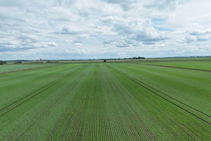
- Price
- Guide Price£930,000
- Size
- 124.44 acres
Added on 13/06/2026Farmland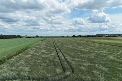
- Price
- Guide Price£895,000
- Size
- 119.33 acres
Added on 13/06/2026Farmland
- Price
- Guide Price£650,000
- Size
- 84.1 acres
Added on 22/06/2026Farmland