Ambrosden, Bicester, Oxfordshire, OX25
- Land size
- 18.37 acres
Description
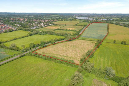
Lot 1 Land at Blackthorn Hill provides a parcel of arable land on the outskirts of Ambrosden. In Pink on the plan the land has access via the B4011 and there is a PD consent for the erection of an agricultural barn on Lot 1.
In all extending to 18.37 acres (7.44 ha) | For sale by private treaty as a whole.
Location
The property is located to the southeast of Bicester (1.7 miles) and on the edge of the village of Ambrosden (less than 1 mile). Train stations are found in Bicester with services to London Marylebone (1h). The A41 and M40 are nearby to the property, providing good access to Bicester and London.
Amenities
Shops, a primary school, public houses and a church are all available in the village of Ambrosden. Further amenities, such as larger shopping centres and schools are available in the nearby town of Bicester.
Land
Suitable for a variety of uses, subject to planning Lot 1 (Pink) extends to some 18.37 acres (7.44 ha) of land in an arable rotation and includes half a pond to the westerly end.
The land is level, well managed and classified as a mix of Grade 3 and Grade 4 and is further designated as having predominantly slowly permeable base-rich loamy and clayey soils.
Method of Sale
For sale by private treaty as a whole.
Tenure & Possession
The property will be sold with vacant possession.
Overage
It is anticipated that an overage will be placed on the land on disposal and purchasers should give consideration to this in any approach.
Services
We have not undertaken our own investigations but understand that no mains services are connected.
Wayleaves, Easements & Rights of Way
The property is sold subject to the benefit of all rights including rights of way, whether public or private, light, support, drainage, water and electricity supplies and other rights and obligations, easements and proposed wayleaves from masts, pylons, stays, cables, drains, water, gas and other pipes, whether specifically referred to or not.
Purchasers should note a footpath runs along the edge of Lot 1.
Planning
There is prior approval for a New Grain Store under reference 24/00904/AGN from Cherwell District Council. The build has to be completed prior to 03 April 2029.
Health & Safety
All viewings are carried out at the sole risk of the viewer and neither the selling agents nor the vendor takes responsibility.
Sporting Timber & Mineral Rights
The mineral, sporting and timber rights are included in the sale of the freehold in so far as they are owned.
Local Authority
Cherwell District Council
Viewings
Interested parties may view the property unaccompanied with details to hand upon prior notification to the selling agent.
Map Location
Property details
- Tenure
- Ask Agent
- Council Tax Band
- TBC
- Date Posted
- 2026-06-11
Market Value Analysis
Compared with 59 Farmland & Pasture listings in South East England (10+ acres).
Utilities & Restrictions
Utilities
- Electricity
- Ask Agent
- Water
- Ask Agent
- Heating
- Ask Agent
- Broadband
- Ask Agent
- Sewerage
- Ask Agent
Rights & Restrictions
- Public Rights of Way
- Ask Agent
- Private Rights of Way
- Ask Agent
- Listed Property
- Ask Agent
- Restrictions
- Ask Agent
Property Features
- Accessibility
- Ask Agent
- Parking
- Ask Agent
- Garden
- Ask Agent
Important notice: Information, maps and tags on this page are supplied by the advertising agent or generated automatically. LandSale has not verified them. Relying on these details is at your own risk, always carry out independent checks before committing to a purchase.
LandSale full disclaimer
Marketing information only - not formal particulars. The details on this website are provided for general guidance and do not constitute an offer or contract. Neither LandSale nor the advertising estate/land agent accepts responsibility for any inaccuracy.
1. Source of information
- Agent-supplied content: Core description, asking price, tenure, measurements, photographs and planning history are uploaded by the appointed agent, who remains solely responsible for their accuracy.
- Automated tags & categorisation: Property type, land-use class, acreage bands and similar labels may be applied by machine-learning models. They are intended as a helpful guide only and may not reflect the property's legal status or permitted use.
- Third-party & enriched data layers: Maps, boundary outlines, planning designations, soil reports, broadband coverage and other environmental or location-based insights are licensed from external suppliers. Such data are supplied “as is", may be incomplete or out of date and are subject to change without notice.
2. Verification required
Prospective purchasers must verify critical matters, including but not limited to planning permission, title boundaries, public rights of way, environmental constraints, acreage, services, access and VAT status, through their own inspections, specialist surveys, legal advisers and the selling agent before relying on the information or entering into any contract.
3. No warranty or liability
LandSale gives no warranty, express or implied, as to the accuracy, completeness or fitness for any particular purpose of the information displayed. LandSale shall not be liable for any loss, damage, cost or expense arising directly or indirectly from any use of or reliance on such information, save where liability may not be excluded by law.
4. Updates & feedback
If you believe any detail on this listing is inaccurate, please let us know. We will investigate and, where appropriate, update the listing or notify the agent.
© LandSale | Version 1.2 - January 2026
Listing agent
Carter Jonas Rural, Oxford
Mayfield House, 256 Banbury Road, Oxford, OX2 7DE
Contact Carter Jonas Rural, Oxford
Mayfield House, 256 Banbury Road, Oxford, OX2 7DE
View agent profileSimilar properties for sale
- Price
- Offers in Excess of£400,000
- Size
- 24.09 acres
Ambrosden, Bicester, Oxfordshire, OX25, Ambrosden, Oxfordshire OX25 1TL England
Added on 11/06/2026Agricultural Land
- Price
- £325,000
- Size
- 0.48 acres
Added on 29/04/2026Agricultural Land
- Price
- Offers in Excess of£250,000
- Size
- 2.49 acres
Berrick Salome, Roke, Wallingford, Berrick Salome, Oxfordshire OX10 6JE England
Added on 16/04/2026Vacant Land
- Price
- Guide Price£220,000
- Size
- 18.14 acres
Shutlanger, Towcester, Shutlanger, West Northamptonshire NN12 7RR England
Added on 29/01/2026Arable Land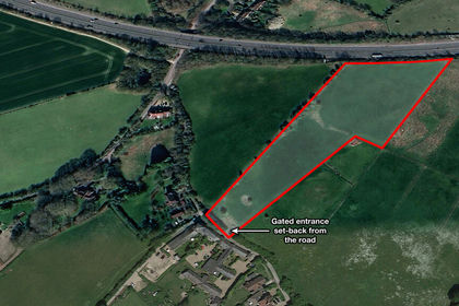
- Price
- Guide Price£195,000
- Size
- 5.04 acres
Barns View Paddock, Tring, Hertfordshire, Tring, Hertfordshire HP23 6JJ England
Added on 17/07/2026Vacant Land
- Price
- Guide Price£230,000
- Size
- 27.52 acres
Added on 29/01/2026Pasture
- Price
- Guide Price£180,000
- Size
- 9.02 acres
Badby Lane, Staverton, Daventry, Staverton, West Northamptonshire NN11 6DE England
Added on 29/01/2026Pasture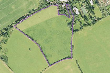
- Price
- Offers in Excess of£210,000
- Size
- 12.17 acres
great gaddesden, Great Gaddesden, Hertfordshire HP1 3BU England
Added on 16/07/2026Farmland
- Price
- Guide Price£275,000
- Size
- 19.17 acres
Church Road, Flitwick, Bedfordshire, MK45 1AE, Flitwick, Central Bedfordshire MK45 5AL England
Added on 23/07/2026Arable Land
- Price
- £250,000
- Size
- 3.4 acres
Bottom House Farm Lane, Chalfont St. Giles, HP8, Amersham, Buckinghamshire HP8 4EF England
Added on 14/02/2026Grazing Land