Stoke Talmage, Thame, Oxfordshire, OX9
- Land size
- 4.93 acres
Description
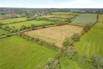
The land at Stoke Grange Farm provides a block of pastureland on the outskirts of the village of Stoke Talmage. It has access via a track from the centre of the village and is currently used for grazing.
In all extending to 4.93 acres (2 ha) | For sale by private treaty as a whole.
Location
The property is located to the southeast of Oxford (8 miles). Train stations are found in Oxford and Thame (4 miles) which provide direct trains to London Paddington and London Marylebone, while the nearby M40 offers convenient access to both London and Oxford.
Amenities
Shops, a primary school, public houses and a church are all available in the village of Tetsworth, around 1.3 miles from the property. Further amenities, such as larger shopping centres and schools are available in the nearby town of Thame and city of Oxford.
Land
The land extends to 4.93 acres (2 ha) in all and is divided into 2 parcels of fenced pasture. Purchasers should note that there is a right of way from a council maintained road which in turn then serves Stoke Grange Farm via a right of way over the subject property.
The land is laid down to pasture and is level, clean and well managed. The land is classified as Grade 3 and is further designated as having predominantly slowly permeable seasonally wet slightly acid but base-rich loamy and clayey soils.
Method of Sale
For sale by private treaty as a whole.
Tenure & Possession
The property will be sold freehold with vacant possession on completion.
Designations
The property sits within The Chilterns National Landscape Area.
Services
We have not undertaken our own investigations but understand that no mains services are connected.
Wayleaves, Easements & Rights of Way
The property is sold subject to the benefit of all rights including rights of way, whether public or private, light, support, drainage, water and electricity supplies and other rights and obligations, easements and proposed wayleaves from masts, pylons, stays, cables, drains, water, gas and other pipes, whether specifically referred to or not.
The property benefits from a right of way from a council maintained road.
Health & Safety
All viewings are carried out at the sole risk of the viewer and neither the selling agents nor the vendor takes responsibility.
Local Authority
South Oxfordshire District Council
Viewings
Interested parties may view the property unaccompanied with details to hand upon prior notification to the selling agent.
Map Location
Property details
- Tenure
- Ask Agent
- Council Tax Band
- TBC
- Date Posted
- 2026-06-11
Market Value Analysis
Compared with 122 Farmland & Pasture listings in South East England (1+ acres).
Utilities & Restrictions
Utilities
- Electricity
- Ask Agent
- Water
- Ask Agent
- Heating
- Ask Agent
- Broadband
- Ask Agent
- Sewerage
- Ask Agent
Rights & Restrictions
- Public Rights of Way
- Ask Agent
- Private Rights of Way
- Ask Agent
- Listed Property
- Ask Agent
- Restrictions
- Ask Agent
Property Features
- Accessibility
- Ask Agent
- Parking
- Ask Agent
- Garden
- Ask Agent
Important notice: Information, maps and tags on this page are supplied by the advertising agent or generated automatically. LandSale has not verified them. Relying on these details is at your own risk, always carry out independent checks before committing to a purchase.
LandSale full disclaimer
Marketing information only - not formal particulars. The details on this website are provided for general guidance and do not constitute an offer or contract. Neither LandSale nor the advertising estate/land agent accepts responsibility for any inaccuracy.
1. Source of information
- Agent-supplied content: Core description, asking price, tenure, measurements, photographs and planning history are uploaded by the appointed agent, who remains solely responsible for their accuracy.
- Automated tags & categorisation: Property type, land-use class, acreage bands and similar labels may be applied by machine-learning models. They are intended as a helpful guide only and may not reflect the property's legal status or permitted use.
- Third-party & enriched data layers: Maps, boundary outlines, planning designations, soil reports, broadband coverage and other environmental or location-based insights are licensed from external suppliers. Such data are supplied “as is", may be incomplete or out of date and are subject to change without notice.
2. Verification required
Prospective purchasers must verify critical matters, including but not limited to planning permission, title boundaries, public rights of way, environmental constraints, acreage, services, access and VAT status, through their own inspections, specialist surveys, legal advisers and the selling agent before relying on the information or entering into any contract.
3. No warranty or liability
LandSale gives no warranty, express or implied, as to the accuracy, completeness or fitness for any particular purpose of the information displayed. LandSale shall not be liable for any loss, damage, cost or expense arising directly or indirectly from any use of or reliance on such information, save where liability may not be excluded by law.
4. Updates & feedback
If you believe any detail on this listing is inaccurate, please let us know. We will investigate and, where appropriate, update the listing or notify the agent.
© LandSale | Version 1.2 - January 2026
Listing agent
Carter Jonas Rural, Oxford
Mayfield House, 256 Banbury Road, Oxford, OX2 7DE
View agent profileSimilar properties for sale
- Price
- Offers in Excess of£100,000
- Size
- 5.72 acres
Ambrosden, Bicester, Oxfordshire, OX25, Ambrosden, Oxfordshire OX25 2DH England
Added on 11/06/2026Undeveloped Land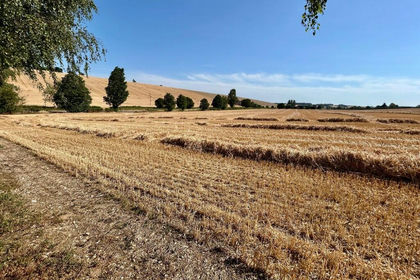
- Price
- Offers in Excess of£100,000
- Size
- 10 acres
Added on 17/07/2026Arable Land
- Price
- Guide Price£95,000
- Size
- 2.66 acres
Banbury Lane, Culworth, Banbury, Culworth, West Northamptonshire OX17 2HL England
Added on 27/06/2026Pasture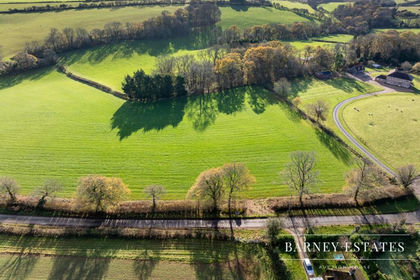
- Price
- Guide Price£100,000
- Size
- 3.2 acres
Steeles Farm, Ashmansworth, RG20, Ashmansworth, Hampshire RG20 9ST England
Added on 13/06/2026Grazing Land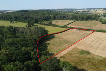
- Price
- Guide Price£100,000
- Size
- 4.06 acres
Land At Bedwyn Brail, Great Bedwyn, Marlborough, SN8, Great Bedwyn, Wiltshire SN8 3LY England
Added on 21/07/2026Agricultural Land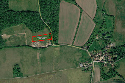
- Price
- Guide Price£85,000
- Size
- 2.04 acres
Westwood Paddock near Normandy, Guildford, Surrey, Wanborough, Surrey GU3 2JR England
Added on 17/07/2026Grazing Land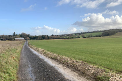
- Price
- Guide Price£59,000
- Size
- 2.35 acres
Greys Smallholding, Wanborough, Guildford, Surrey, Wanborough, Surrey GU3 2JR England
Added on 17/07/2026Vacant Land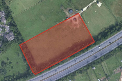
- Price
- Guide Price£50,000
- Size
- 4.16 acres
Of Dove Place, Holroyd Road, Claygate, Claygate, Surrey KT10 0LD England
Added on 21/07/2026Grazing Land