St Margarets Road, Alderton,
Key Features
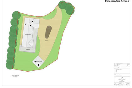
- Village Building Plot with Full Planning Permission
- Proposed Individual Three Bedroom Detached House
- Kitchen/Dining and Sitting Room
- Utility Room
- Cloakroom
- Bathroom and Potential Ensuite (stp)
- Driveway Parking
- Generous Garden
- Central Village Location
Description
This exceptional building plot, situated in the heart of Alderton on the edge of the Cotswolds, offers a rare opportunity to construct a bespoke, detached three bedroom residence.
Representing a compelling proposition for self-builders and boutique developers alike, the plot is situated in an established residential setting near the historic St Margarets Church. The approved plans (23/00720/FUL and 25/00008/NMA) provide for a substantial two storey home designed with a focus on light and modern flow. The layout features three double bedrooms and generous ground floor living spaces, all designed to sit harmoniously within this mature village location.
The project has been carefully refined to ensure a contemporary internal layout while utilising traditional materials that complement the village’s character. This ensures the new dwelling will offer the benefits of modern construction and thermal efficiency without compromising its picturesque surroundings.
Viewings by appointment, the site is secured.
Additional Information - Tenure: Freehold. Council Tax: Not yet rated. Property Construction: Building plot with full planning for a detached dwelling.
Planning: Tewkesbury Borough Council refs: 23/00720/FUL & 25/00008/NMA.
Utilities: Water & Sewerage: None currently connected; mains understood to be available nearby. Electricity: None currently connected; mains understood to be available nearby. Heating: None (Proposed for modern high-efficiency systems).
Broadband: Standard, Superfast (FTTC), and Ultrafast (FTTP) available in the village (Source: Ofcom). Mobile: Likely "Good" outdoor coverage across major networks (Source: Ofcom).
Flood Risk: Flood Zone 1 (Low Risk). "The site is located in Flood Zone 1 and is shown to be at very low risk of surface water flooding on the Environment Agency’s Long Term Flood Risk Map. There is higher risk of surface water flooding closer to the watercourse, the dwelling has been located outside of this area." TBC Land Drainage Advice.
Conservation Area: No.
Covenants/Easements: None currently known to the vendor (excluding standard utility easements).
AML: The successful purchaser will be required to provide verified ID and source of funds prior to solicitors being instructed.
Computer Generated Images (CGI): These images are intended for illustrative purposes only and serve as a visual guide to the potential finished dwelling based on the approved planning permission. These CGIs are an artist's impression and do not constitute a warranty or part of any contract. External finishes, landscaping, and final specifications are indicative and subject to change and nearby buildings and boundaries are not shown to allow viewable angles. Prospective purchasers must satisfy themselves regarding the site's suitability and refer to the full planning documents (Ref: 23/00720/FUL and 25/00008/NMA) available via Tewkesbury Borough Council’s portal.
Situation - Set at the foot of Alderton Hill on the edge of the Cotswolds and just 4 miles north-west of Winchcombe, Alderton is a quintessential English village offering a perfect blend of rural charm and modern convenience. This vibrant community is ideal for families and commuters, located just 7 miles from Tewkesbury and Bishops Cleeve and 10 miles from Cheltenham.
At the heart of the village lies the essential Alderton Village Store and Post Office, alongside The Gardeners Arms, a celebrated 16th-century thatched pub including a Ghurkha restaurant. Ideal for families, the village offers a weekly toddlers group, a preschool, and the Oak Hill Primary School (ages 5–11), alongside an active village hall and the historic church of St Margaret of Antioch.
Outdoor enthusiasts have direct access to the Winchcombe Way for scenic hiking across the Area of Outstanding Natural Beauty. With a friendly, engaged community and high-speed broadband availability, Alderton offers a premium lifestyle for those seeking a tranquil yet connected edge of Cotswolds retreat.
Map Location
Property details
- Tenure
- Freehold
- Council Tax Band
- Ask Agent
- Date Posted
- 2026-06-05
Utilities & Restrictions
Utilities
- Electricity
- Ask Agent
- Water
- Ask Agent
- Heating
- Ask Agent
- Broadband
- Ask Agent
- Sewerage
- Ask Agent
Rights & Restrictions
- Public Rights of Way
- Ask Agent
- Private Rights of Way
- Ask Agent
- Listed Property
- Ask Agent
- Restrictions
- Ask Agent
Property Features
- Accessibility
- Ask Agent
- Parking
- Parking Available
- Garden
- Garden
Important notice: Information, maps and tags on this page are supplied by the advertising agent or generated automatically. LandSale has not verified them. Relying on these details is at your own risk, always carry out independent checks before committing to a purchase.
LandSale full disclaimer
Marketing information only - not formal particulars. The details on this website are provided for general guidance and do not constitute an offer or contract. Neither LandSale nor the advertising estate/land agent accepts responsibility for any inaccuracy.
1. Source of information
- Agent-supplied content: Core description, asking price, tenure, measurements, photographs and planning history are uploaded by the appointed agent, who remains solely responsible for their accuracy.
- Automated tags & categorisation: Property type, land-use class, acreage bands and similar labels may be applied by machine-learning models. They are intended as a helpful guide only and may not reflect the property's legal status or permitted use.
- Third-party & enriched data layers: Maps, boundary outlines, planning designations, soil reports, broadband coverage and other environmental or location-based insights are licensed from external suppliers. Such data are supplied “as is", may be incomplete or out of date and are subject to change without notice.
2. Verification required
Prospective purchasers must verify critical matters, including but not limited to planning permission, title boundaries, public rights of way, environmental constraints, acreage, services, access and VAT status, through their own inspections, specialist surveys, legal advisers and the selling agent before relying on the information or entering into any contract.
3. No warranty or liability
LandSale gives no warranty, express or implied, as to the accuracy, completeness or fitness for any particular purpose of the information displayed. LandSale shall not be liable for any loss, damage, cost or expense arising directly or indirectly from any use of or reliance on such information, save where liability may not be excluded by law.
4. Updates & feedback
If you believe any detail on this listing is inaccurate, please let us know. We will investigate and, where appropriate, update the listing or notify the agent.
© LandSale | Version 1.2 - January 2026
Listing agent
Adams Estate Agents, Winchcombe
20 North Street, Winchcombe, GL54 5PS
Similar properties for sale
- Price
- Offers Over£200,000
Added on 15/07/2026Building Plot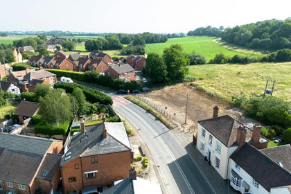
- Price
- Guide Price£150,000
- Size
- 0.23 acres
Worcestershire, Severn Stoke, Worcestershire WR8 9JA England
Added on 11/07/2026Building Plot Added on 25/05/2026Building Plot
- Price
- Offers Over£225,000
Gloucester Road, Welland, Malvern, WR13, Welland, Worcestershire WR13 6LA England
Added on 10/05/2026Self Build Plot
- Price
- Guide Price£195,000
- Size
- 0.07 acres
Building Plot Off School Walk, Whittington, Worcester, Whittington, Worcestershire WR5 2RJ England
Added on 25/06/2026Building Plot
- Price
- From£162,500
Added on 25/05/2026Development Land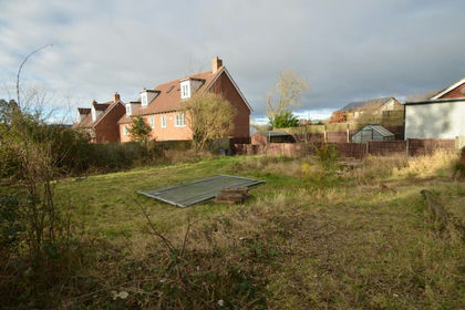
- Price
- Guide Price£175,000
Added on 24/06/2026Building Plot
- Price
- Guide Price£210,000
Tewkesbury Road, Newent, Oxenhall, Gloucestershire GL18 1FW England
Added on 13/06/2026Self Build Plot Added on 29/01/2026Building Plot
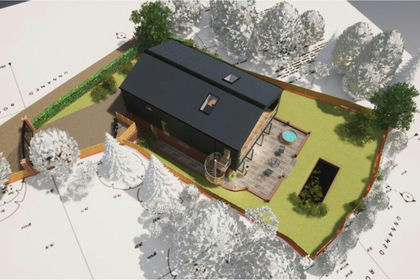
- Price
- Offers Over£180,000
Hawford Wood, Ombersley, Droitwich, Worcestershire, WR9, Ombersley, Worcestershire WR9 0EZ England
Added on 28/01/2026Building Plot