Land at Gretton, Northamptonshire - About 26.66 acres
- Land size
- 26.66 acres
Key Features
- Two fields of long-established grassland situated between the villages of Gretton and Lyddington
- Gretton ½ mile, Lyddington 3 miles, Corby 4½ miles, Uppingham 5½ miles
- About 26.66 acres
- For sale as a whole
- Guide Price £180,000
Description
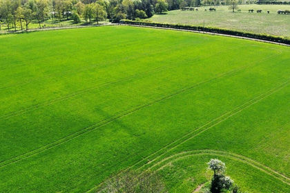
Two fields of long-established grassland situated between the villages of Gretton and Lyddington.
.
Gretton ½ mile, Lyddington 3 miles, Corby 4½ miles, Uppingham 5½ miles
About 26.66 acres.
For sale as a whole.
Guide Price £180,000
Situation - The land is situated by the River Welland, near to the village of Gretton, with gated vehicular access directly off Mill Road.
The Land - The land extends to approximately 26.66 acres in total and consists of two fields of long-established grassland (being 13.94 acres and 12.72 acres respectively). Both fields interconnect and have ridge and furrow topography, with the smaller field containing a central pond.
The land is currently subject to a Farm Business Tenancy, which will expire on the 29th September 2026.
Method Of Sale - The freehold land is offered for sale as a whole by private treaty with vacant possession on completion.
Services - There are no services connected to the land.
Easements, Covenants & Wayleaves - We are not aware of any easements, covenants or wayleaves, however, the land is sold subject to any that may exist.
Basic Payment - There are no delinked payments available to the Buyer.
Environmental Schemes - The land is part of a Sustainable Farming Incentive Agreement that commenced on the 1st February 2024 and ends on the 31st January 2027. Further details are available from the Seller's Agents.
Sporting, Timber And Mineral Rights - All sporting, timber and mineral rights are included in the freehold sale, in so far as they are owned, save for the land hatched blue on the plan, where the mines and minerals are excepted.
Local Authority - North Northamptonshire Council (unitary authority)
Vat - Any guide price quoted or discussed is exclusive of VAT. In the event that a sale of the land, or any part of it, or any right attached to it, becomes a chargeable supply for the purposes of VAT, such tax will be payable in addition.
Viewings - The land may be viewed at any reasonable time with a copy of these particulars to hand subject to prior notification to one of the Seller’s Agents. Viewing is at your own risk and neither Shouler & Son, Chater Advisory Ltd nor the vendor take any responsibility for any losses or damages incurred during inspection.
What3words Access Point - insisting.limp.diplomat
Map Location
Property details
- Tenure
- Freehold
- Council Tax Band
- Ask Agent
- Date Posted
- 2026-06-02
Market Value Analysis
Compared with 57 Farmland & Pasture listings in East Midlands (25+ acres).
Utilities & Restrictions
Utilities
- Electricity
- Ask Agent
- Water
- Ask Agent
- Heating
- Ask Agent
- Broadband
- Ask Agent
- Sewerage
- Ask Agent
Rights & Restrictions
- Public Rights of Way
- Ask Agent
- Private Rights of Way
- Ask Agent
- Listed Property
- Ask Agent
- Restrictions
- Ask Agent
Property Features
- Accessibility
- Ask Agent
- Parking
- Ask Agent
- Garden
- Ask Agent
Important notice: Information, maps and tags on this page are supplied by the advertising agent or generated automatically. LandSale has not verified them. Relying on these details is at your own risk, always carry out independent checks before committing to a purchase.
LandSale full disclaimer
Marketing information only - not formal particulars. The details on this website are provided for general guidance and do not constitute an offer or contract. Neither LandSale nor the advertising estate/land agent accepts responsibility for any inaccuracy.
1. Source of information
- Agent-supplied content: Core description, asking price, tenure, measurements, photographs and planning history are uploaded by the appointed agent, who remains solely responsible for their accuracy.
- Automated tags & categorisation: Property type, land-use class, acreage bands and similar labels may be applied by machine-learning models. They are intended as a helpful guide only and may not reflect the property's legal status or permitted use.
- Third-party & enriched data layers: Maps, boundary outlines, planning designations, soil reports, broadband coverage and other environmental or location-based insights are licensed from external suppliers. Such data are supplied “as is", may be incomplete or out of date and are subject to change without notice.
2. Verification required
Prospective purchasers must verify critical matters, including but not limited to planning permission, title boundaries, public rights of way, environmental constraints, acreage, services, access and VAT status, through their own inspections, specialist surveys, legal advisers and the selling agent before relying on the information or entering into any contract.
3. No warranty or liability
LandSale gives no warranty, express or implied, as to the accuracy, completeness or fitness for any particular purpose of the information displayed. LandSale shall not be liable for any loss, damage, cost or expense arising directly or indirectly from any use of or reliance on such information, save where liability may not be excluded by law.
4. Updates & feedback
If you believe any detail on this listing is inaccurate, please let us know. We will investigate and, where appropriate, update the listing or notify the agent.
© LandSale | Version 1.2 - January 2026
Listing agent
Shouler & Son, Melton Mowbray
County Chambers, Kings Road, Melton Mowbray, LE13 1QF
Contact Shouler & Son, Melton Mowbray
County Chambers, Kings Road, Melton Mowbray, LE13 1QF
View agent profileSimilar properties for sale
- Price
- Guide Price£200,000
- Size
- 20.78 acres
Honey Pot Lane, Colsterworth, Grantham, Colsterworth, Lincolnshire NG33 5LT England
Added on 18/06/2026Farmland
- Price
- Guide Price£200,000
- Size
- 64.61 acres
Added on 13/02/2026Pasture
- Price
- Guide Price£220,000
- Size
- 18.14 acres
Shutlanger, Towcester, Shutlanger, West Northamptonshire NN12 7RR England
Added on 29/01/2026Arable Land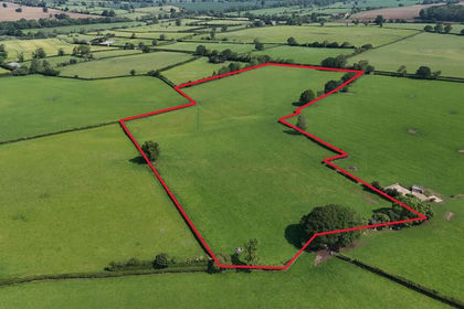
- Price
- Guide Price£140,000
- Size
- 13.79 acres
Land at, Abthorpe, Towcester, Abthorpe, West Northamptonshire NN12 8WB England
Added on 24/06/2026Pasture
- Price
- Guide Price£210,000
- Size
- 24.43 acres
Land At Haven Drove, Willingham, Cambridgeshire, CB24 8QF, Rampton, Cambridgeshire CB24 8QF England
Added on 04/07/2026Arable Land