Whitmore Vale Road, Grayshott, Hindhead, Surrey, GU26
- Land size
- 1.4 acres
- Bedrooms
- 3
- Bathrooms
- 2
Description
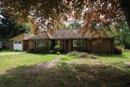
A truly special opportunity, set within grounds approaching 1.4 acres of formal gardens and woodland running down to a stream, all nestled within the woodland of The Golden Valley (National Trust).
Situated on a rural road meandering through woodland linking the charming villages of Churt and Grayshott, Silver Birch Cottage enjoys a tucked away and private position whilst only being a few minutes’ drive from village amenities.
Situated within south facing gardens, although in a plot of almost 1.4 acres, you can find the sun or shade at any point throughout the day, and there are so many elements of the garden to discover, from lawns and patios, to the orchard and down to Barford stream.
There are two driveway entrances, the formal large driveway offers parking for several vehicles leading to a detached double garage, whilst the 2nd smaller drive leads to another workshop with loft above.
From the main porch you step into an entrance hall with shower room and access to the principle reception rooms, with a door through to a large hall (once the original entrance into the house) with access to the kitchen and bedrooms.
One of the first rooms you approach is the spacious dining room with a Clearview wood burning stove and patio doors which open onto an easterly aspect, from here you enter the triple aspect sitting room. Predominantly south facing but enjoying sun throughout the day with patio doors out onto a terrace and the garden beyond. For the winter months there is an attractive
brick fireplace with working open fire.
As always the kitchen is the heart of the home and this dual aspect kitchen has plenty of space for a breakfast table, ideal for casual mealtimes, a spot to do homework or just chat over a brew. There is an LPG gas Aga, 2 ring electric hob, integrated electric Neff oven/microwave with further space for a dishwasher and fridge freezer.
Bonus room! A third double aspect reception room (an ideal family room with patio doors out onto a west facing courtyard) or a great fourth ground floor bedroom.
Moving to the first floor, the master bedroom benefits from a dressing room/study and built in wardrobes, a spacious 2nd double bedroom with a dual aspect and built in wardrobes and a good sized third bedroom (used to have two singles in it!) with built in wardrobes. All serviced by a family bathroom. On the top landing there are two additional good sized storage cupboards and an airing cupboard.
There are numerous outbuildings to compliment the main accommodation and if desired there would be scope to extend STPP.
Woodland walks can be enjoyed from just across the road where Windy Gap leads you into the rest of The Golden Valley.
Without exaggeration the gardens here are exceptional; viewing is needed to appreciate all the nuances and tucked away areas, with almost 1.4 acres there is quite a lot to find! The current owners have lovingly tended the gardens for over 40 years and the borders are packed with mature shrubs. There are two defined patio areas, large lawns, an orchard with greenhouse and fruit cages, several storage sheds and outbuildings plus two summerhouses with an apple store behind. Centrally positioned within the garden is a large magnolia tree providing beautiful Spring colour, under which a well is situated; no longer believed to contain water it is still a lovely feature. Other mature plants of note are the wisteria flanking the sitting room and several large rhododendrons and azaleas. Towards the latter half of the gardens is a gate into a more woodland style of garden, beyond which is the stream that edges the boundary. It is a haven for wildlife and is a special area to explore and enjoy.
Tenure: Freehold
EPC Rating: E Council Tax Band: F (Correct at time of publication and is subject to change following a council revaluation after a sale)
Services: The property has mains water, electricity, LPG gas fired central heating to radiators and private drainage. Broadband and Mobile services: Visit checker.ofcom.org.uk
Location: Whitmore Vale Road is a desirable leafy road running through the woodland of The Golden Valley linking the picturesque village of Grayshott and Churt on the edge of The Surrey Hills Area of Outstanding Natural Beauty. A rural idyll within only minutes of village life and facilities.
Grayshott is a thriving, award winning village situated on the Surrey/Hampshire border, surrounded by National Trust woodlands, offering a wealth of individual shops and services which include; Post Office, village pub, social club, restaurants, cafes & takeaways, two small supermarkets, butcher, greengrocer, ironmonger, chemist, doctors, dentists, sports field with pavilion and tennis club.
The village school incorporates both infants and juniors, with PK preschool on a site adjoining the school. Secondary education is well covered by Woolmer Hill, Bohunt, or Weydon, whilst there are a large number of private schools and preschools (including St Edmund’s and Amesbury at Hindhead as well as Brookham and Highfield in Liphook and Frensham Heights in Frensham. Other schools include Charterhouse at Godalming, Barrow Hills and King Edward’s at Witley, and Bedales and Cranleigh School slightly further afield).
Churt is a delightful village, on the edge of the Surrey Hills Area of Outstanding Natural Beauty, with children’s play area and cricket pitch, football pitches, tennis club and local pub. St Johns village Infant school is the local school which is highly regarded in the area. Churt is close to areas of outstanding natural beauty which include Frensham Ponds and Hankley Common, offering many acres of common land, ideal for walking and riding.
Close by, there are several Golf Courses, including Hindhead Golf Course which was founded in 1904 by Sir Arthur Conan Doyle. Further sporting facilities include racing at Goodwood and Fontwell, polo at Cowdray Park and sailing on Frensham Ponds and off the south coast at Chichester Harbour.
The larger towns of Haslemere and Farnham are both within 10 miles, offering high street shopping and main line rail connections to London in less than an hour. Access to the A3 is easy, with motorway style connections to London, the South coast and both principal Airports.
Map Location
Property details
- Tenure
- Freehold
- Council Tax Band
- F
- Date Posted
- 2026-05-27
Price history
| Date | Change | Price |
|---|---|---|
| 31 Jul 2026 | Reduced 4.3% (−£50,000) | £1,100,000 |
| Until 31 Jul 2026 | Asking price | £1,150,000 |
Market Value Analysis
Compared with 1,735 Homes with Land listings in South East England (1+ acres).
Energy Performance Certificate
Energy Efficiency Rating
Based on UK Energy Performance Certificate standards (EU Directive 2002/91/EC)
Running costs are one side. Planning activity, flood history and ground risks for this location are in the full report.
Utilities & Restrictions
Utilities
- Electricity
- Ask Agent
- Water
- Ask Agent
- Heating
- Ask Agent
- Broadband
- Ask Agent
- Sewerage
- Ask Agent
Rights & Restrictions
- Public Rights of Way
- Ask Agent
- Private Rights of Way
- Ask Agent
- Listed Property
- Ask Agent
- Restrictions
- Ask Agent
Listed status, conservation areas and planning constraints for this location are in the full report.
Property Features
- Accessibility
- Ask Agent
- Parking
- Parking Available
- Garden
- Garden
Beyond the particulars: planning activity, flood history, heritage and ground risks, checked for this exact spot.
Connectivity
Broadband
Fastest speed available at this postcode
1 Gbps
Gigabit full fibre · available to 4% of premises
Suitable for
- 4K streaming on every screen
- Full-time home working
- Online gaming & big downloads
Mobile signal
Predicted 4G and 5G signal; indoor signal depends on building materials.
Ofcom Connected Nations postcode-level predictions. Speeds and signal are modelled, not measured, and vary between addresses and providers.
Signal is the easy part. Planning activity, flood history and protected designations here are in the full report.
Nearest Schools
Primary
- Beacon Hill Primary School0.7 milesNo Ofsted rating
- Ages
- 2 to 11
- Pupils
- 186
- Type
- Academy converter
- Grayshott Church of England Controlled Primary School0.8 milesOfsted report card · Apr 2026
- Ages
- 4 to 11
- Pupils
- 214
- Type
- Voluntary controlled school
- Faith
- Church of England
- St John's CofE Aided Infant School1.1 milesOfsted: Good
- Ages
- 4 to 7
- Pupils
- 45
- Type
- Voluntary aided school
- Faith
- Church of England
- The Holme Church of England Primary School2.5 milesNo Ofsted rating
- Ages
- 4 to 11
- Pupils
- 179
- Type
- Academy sponsor led
- Faith
- Church of England
- Shottermill Junior School2.6 milesNo Ofsted rating
- Ages
- 7 to 11
- Pupils
- 251
- Type
- Community school
Secondary
- Woolmer Hill School2.2 milesNo Ofsted rating
- Ages
- 11 to 16
- Pupils
- 892
- Type
- Academy converter
- Bohunt School3.4 milesOfsted: Good
- Ages
- 11 to 18
- Pupils
- 2,012
- Type
- Academy converter
- Oakmoor School3.5 milesOfsted report card · Jan 2026
- Ages
- 11 to 16
- Pupils
- 912
- Type
- Academy sponsor led
- Weydon School5.9 milesOfsted: Good
- Ages
- 11 to 16
- Pupils
- 1,666
- Type
- Academy converter
- Rodborough6 milesOfsted report card · Jun 2026
- Ages
- 11 to 16
- Pupils
- 882
- Type
- Academy converter
Distances are straight-line from the advertised location. Source: the national school registers (DfE, Welsh Government, Scottish Government) and Ofsted.
Schools are just the start: sold prices nearby, planning activity and any flood history are in the full report.
Amenities
Supermarket
GP surgery
Pharmacy
Hospital
Green space
Straight-line distances from the advertised location. Sources: NHS records, Geolytix supermarket locations, OS Open Greenspace and the national trails registers.
The area stacks up? Now check the location itself: planning nearby, protected designations and past flooding.
Getting Around
Nearest station
Nearest bus stop
Typical drive times
Straight-line distances from the advertised location; drive times are typical free-flow times over OpenStreetMap road data, so allow more at peak. Public transport locations from DfT NaPTAN.
Easy to reach matters. So do planning activity, flood history and ground risks: all in the full report.
Flood Risk
Environment Agency open data, checked around the advertised map pin for the listed acreage. Long-term risk counts flood defences; the planning map's flood zones do not. Provided by LandSale, not the listing agent, and not part of the agent's particulars. Risk varies across a holding, so verify before committing.
Rivers and the sea
Planning map: Flood Zone 1.
Surface water
These bandings are the summary. Where this location sits on the flood maps, plus planning activity, heritage and ground risks, is in the full report.
Important notice: Information, maps and tags on this page are drawn from the advertising agent's marketing materials or generated automatically. LandSale has not verified them. Relying on these details is at your own risk, always carry out independent checks before committing to a purchase.
LandSale full disclaimer
Marketing information only - not formal particulars. The details on this website are provided for general guidance and do not constitute an offer or contract. Neither LandSale nor the advertising estate/land agent accepts responsibility for any inaccuracy.
1. Source of information
- Listing content: Core description, asking price, tenure, measurements, photographs and planning history originate from the marketing materials of the advertising estate or land agent. LandSale does not author this content and cannot guarantee its accuracy.
- Automated tags & categorisation: Property type, land-use class, acreage bands and similar labels may be applied by machine-learning models. They are intended as a helpful guide only and may not reflect the property's legal status or permitted use.
- Third-party & enriched data layers: Maps, boundary outlines, planning designations, soil reports, broadband coverage and other environmental or location-based insights are licensed from external suppliers. Such data are supplied “as is", may be incomplete or out of date and are subject to change without notice.
2. Verification required
Prospective purchasers must verify critical matters, including but not limited to planning permission, title boundaries, public rights of way, environmental constraints, acreage, services, access and VAT status, through their own inspections, specialist surveys, legal advisers and the selling agent before relying on the information or entering into any contract.
3. No warranty or liability
LandSale gives no warranty, express or implied, as to the accuracy, completeness or fitness for any particular purpose of the information displayed. LandSale shall not be liable for any loss, damage, cost or expense arising directly or indirectly from any use of or reliance on such information, save where liability may not be excluded by law.
4. Updates & feedback
If you believe any detail on this listing is inaccurate, please let us know. We will investigate and, where appropriate, update the listing or notify the agent.
© LandSale | Version 1.3 - August 2026
Listing agent
Seymours Estate Agents, Grayshott
Aberdeen House Headley Road, Grayshott, Hindhead, GU26 6LD
Contact Seymours Estate Agents, Grayshott
Aberdeen House Headley Road, Grayshott, Hindhead, GU26 6LD
View agent profileSimilar properties for sale
- Price
- £850,000
- Size
- 1 acres
Added on 29/01/2026Residential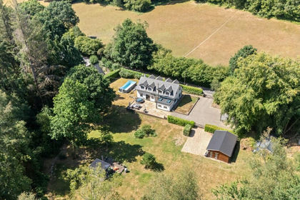
- Price
- Guide Price£1,350,000
- Size
- 1.2 acres
Sandy Lane, Haslemere, Hampshire, GU27, Bramshott and Liphook, Hampshire GU27 England
Added on 04/09/2026House with Land
- Price
- Guide Price£1,250,000
- Size
- 1.6 acres
Sandy Lane, Rushmoor, Farnham, Surrey, GU10, Frensham, Surrey GU10 England
Added on 22/09/2026House with Land
- Price
- Guide Price£825,000
- Size
- 2.5 acres
Old Lane, Dockenfield, Farnham, GU10, Dockenfield, Surrey GU10 England
Added on 12/08/2026Cottage
- Price
- Offers in Excess of£1,250,000
- Size
- 4.2 acres
Added on 12/06/2026House with Land
- Price
- Offers in Region of£1,200,000
- Size
- 4 acres
Added on 18/09/2026House with Land
- Price
- Guide Price£1,300,000
- Size
- 1.55 acres
Petworth Road, Wormley, Godalming, Surrey, GU8, Witley and Milford, Surrey GU8 England
Added on 11/03/2026House with Land
- Price
- Offers Over£1,150,000
- Size
- 1.2 acres
Amberley Lane, Milford, Godalming, GU8, Witley and Milford, Surrey GU8 England
Added on 04/09/2026Farmhouse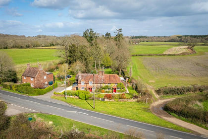
- Price
- Guide Price£900,000
- Size
- 1 acres
Fisher Street, Northchapel, GU28, Northchapel, West Sussex GU28 England
Added on 08/04/2026House with Land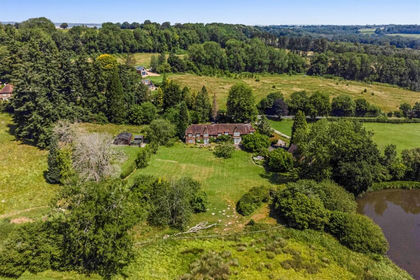
- Price
- Guide Price£1,250,000
- Size
- 3 acres
Added on 03/10/2026House with Land