Borwicks Aynsome - Lot 3, Aynsome Road, Cartmel, Grange-Over-Sands, Cumbria
- Land size
- 16.93 acres
Key Features
- High quality agricultural meadow and pasture land
- Extending in all to approximately 16.93 acres [6.85 hectares]
- Benefits from direct roadside access
- Natural water supplies
- Highly sought after area and will be of interest to hobby farmers/ smallholders, those with equestrian interests, investors or local land and property owners.
Description
OLD ELM FIELDS
Extending in all to circa 16.93 acres [6.85 Hectares] Shaded Pink on the Sale Plan
Description
Three enclosures of productive meadow/ pastureland benefitting from good roadside access. Boundaries comprise predominantly mature hedgerows and post/ wire fences, all of which are deemed stockproof.
If sold separately, the successful purchaser of Lot 3 will have the right to connect into the water supply of Borwicks Aynsome (Lot 1), directly from the troughs located within parcel 5235 and between 6327 and 7539.
There is a clawback agreement in place over Lot 3. The overage payment equates to 30% uplift in value of the land, due on the commencement of development of any non-agricultural/ equestrian use for a period of 20 years.
*Note – If sold separately from Lot 1, a new stockproof fence is to be erected, by the successful purchaser of Lot 1, across parcel 5235, between points C and D on the plan attached to these Sales Particulars within 3 months from the date of completion.
Complementary Opportunity
Please note that the Old Elm Fields are included in a wider sale, comprising two further lots, as follows:
Lot 1 – Borwicks Aynsome – Five bedroom farmhouse and range of traditional stone barns. Located to the immediate north of the land.
Lot 2 – Little Aynsome – Detached two bedroom bungalow. Located in the northwesterly corner of parcel 5235.
If acquired in combination, the above lots form a well-rounded rural holding with real flexibility – equally suited to multi-generational living, equestrian or smallholding use, or generating holiday letting/ rental income from this most outstanding location.
Directions
From Junction 36 of the M6 motorway take the A590 and after approximately 3.5 miles take the slip road to Barrow/Milnthorpe. Taking the first exit on the roundabout, continue 5 miles to the Meathop roundabout and take the 2nd exit on to Lindale Bypass. After 2 miles take the exit to Cartmel and continue for 1 mile, before turning left on to Green Lane and continue for 1.2 miles. The land can be found on your left-hand side, denoted by the selling agents For Sale board.
Location
The land is located 0.7 miles from the idyllic village of Cartmel and only 2 miles from the A590. The land is located just outside of the Lake District National Park, in an extremely attractive and tranquil setting, located only 20 minutes drive from J36 of the M6 motorway. Cartmel is renowned for its 12th Century Priory, variety of shops, traditional pubs, Michelin starred restaurants, racecourse, primary and secondary schools. The land is 2.6 miles from Cark and Grange-over-Sands railway stations and 14 miles from Oxenholme, the Lake District mainline railway station.
Grid Reference: SD
What3words: bland.micro.erupt
Services
Tenure
Freehold. Vacant Possession upon completion.
The land is currently occupied on a grazing agreement. Vacant possession can be obtained following service on one months notice. The property will benefit from vacant possession on completion.
Services
The land benefits from natural water supplies.
Lotting Flexibility
Whilst the wider property is currently offered for sale in the Lots as described above, the vendors remain open to considering offers based on alternative lotting arrangements, subject to agreement.
Interested parties wishing to discuss a variation to the proposed lot structure are invited to contact the selling agents.
Method of Sale
The property forms part of a wider sale which, in its entirety, is available for sale by Private Treaty as a whole, or in 3 separate Lots.
Lot 3 is available as an individual Lot or in combination with Lot(s) 1 and 2.
Wayleaves and Easements
The properties are sold subject to and with the benefit of any existing easements, wayleaves and rights of way. The sale is subject to all the existing rights of way, drainage, light, air support and other easements and quasi-easements and outgoings whether mentioned in these particulars or not.
Boundaries
The responsibility of the ownership of the boundary fences and walls are indicated with 'T' marks on the Sale Plan where known and are from the information provided by the sellers and believed to be correct. The ‘T’ marks indicated on the Sale Plan between individual Lots have been decided by the sellers.
Please Note: If sold separately, the successful purchaser of Borwicks Aynsome (Lot 1) will be required to construct a suitable stockproof fence between points C and D on the plan attached to these particulars, within 3 months of the completion date.
Similarly, the purchaser of Little Aynsome (Lot 2) will be required to construct a suitable stockproof fence between points A and B on the plan attached to these particulars, within 3 months of the completion date.
Sale Plan
The sale plan has been prepared by the selling agent for the convenience of the prospective purchasers. It is deemed to be correct, but any error, omission or mis-statement shall not affect the sale. Purchasers must satisfy themselves as to accuracy.
Stewardship Schemes
Specific parcels are subject to a Countryside Stewardship Mid Tier Agreement, running until 31/12/2028. Further information and individual parcel options are available on request from the selling agent.
Purchasers will be obliged to take over and comply with the agreement requirement, join a new SFI scheme which prevents any reclaims being made or reimburse the vendors for any penalties. The respective purchasers will be required to complete the relevant ‘Transfer In’ form for their respective purchases. Assistance will be available for this but a small fee would be charged on an hourly basis.
Local Authorities
Lot 3 is located just outside of the Lake District National Park and within the Westmorland and Furness Council authority.
Westmorland and Furness Council -
Viewing Arrangements
Lot 3 may be inspected at any reasonable daylight hour by prospective buyers, provided a copy of these particulars are in possession. Please take care when viewing and leave gates as found.
OVERVIEW OF THE WIDER SALE – BORWICKS AYNSOME
Borwicks Aynsome presents a truly rare opportunity to acquire a small rural holding in the heart of the Cartmel Valley. The property has not been openly marketed for over 100 years and occupies an attractive setting within easy reach of the village of Cartmel, with outstanding open views across the surrounding countryside and up towards Hampsfell.
The holding extends in total to approximately 17.96 acres (7.27 hectares), comprising a Grade II listed five bedroom farmhouse, substantial range of traditional stone barns, a detached two bedroom bungalow and three parcels of productive meadow and pasture. Whilst the property requires renovation and modernisation throughout, it offers tremendous scope to form a most attractive rural holding.
Map Location
Property details
- Tenure
- Freehold
- Council Tax Band
- TBC
- Date Posted
- 2026-05-27
Market Value Analysis
Compared with 17 Bare & Undeveloped Land listings in North West England (10+ acres).
Utilities & Restrictions
Utilities
- Electricity
- Ask Agent
- Water
- Ask Agent
- Heating
- Ask Agent
- Broadband
- Ask Agent
- Sewerage
- Ask Agent
Rights & Restrictions
- Public Rights of Way
- Ask Agent
- Private Rights of Way
- Ask Agent
- Listed Property
- Ask Agent
- Restrictions
- Ask Agent
Listed status, conservation areas and planning constraints for this location are in the full report.
Property Features
- Accessibility
- Ask Agent
- Parking
- Ask Agent
- Garden
- Ask Agent
Beyond the particulars: planning activity, flood history, heritage and ground risks, checked for this exact spot.
Connectivity
Broadband
Fastest speed available at this postcode
80 Mbps
Superfast
Suitable for
- HD streaming
- Video calls
- Web & social
Fixed wireless access may also be an option here.
Mobile signal
Outdoor predictions; indoor signal depends on building materials.
Ofcom Connected Nations postcode-level predictions. Speeds and signal are modelled, not measured, and vary between addresses and providers.
Signal is the easy part. Planning activity, flood history and protected designations here are in the full report.
Nearest Schools
Primary
- Cartmel CofE Primary School690 metresOfsted: Good
- Ages
- 4 to 11
- Pupils
- 47
- Type
- Voluntary controlled school
- Faith
- Church of England
- Grange CofE Primary School1.5 milesOfsted: Good
- Ages
- 3 to 11
- Pupils
- 192
- Type
- Voluntary controlled school
- Faith
- Church of England
- Allithwaite CofE Primary School1.5 milesNo Ofsted rating
- Ages
- 3 to 11
- Pupils
- 109
- Type
- Voluntary controlled school
- Faith
- Church of England
- Lindale CofE Primary School2 milesOfsted: Good
- Ages
- 3 to 11
- Pupils
- 47
- Type
- Voluntary controlled school
- Faith
- Church of England
- Flookburgh CofE Primary School2.6 milesNo Ofsted rating
- Ages
- 3 to 11
- Pupils
- 58
- Type
- Foundation school
- Faith
- Church of England
Secondary
- Cartmel Priory CofE School899 metresOfsted report card · May 2026
- Ages
- 11 to 16
- Pupils
- 371
- Type
- Academy converter
- Faith
- Church of England
- Ulverston Victoria High School6.2 milesOfsted: Good *
- Ages
- 11 to 18
- Pupils
- 1,319
- Type
- Community school
- Dallam School7.3 milesOfsted report card · Apr 2026
- Ages
- 11 to 18
- Pupils
- 761
- Type
- Academy converter
- Carnforth High School9.2 milesOfsted report card · Apr 2026
- Ages
- 11 to 16
- Pupils
- 657
- Type
- Academy converter
- Morecambe Bay Academy9.8 milesOfsted: Good
- Ages
- 11 to 18
- Pupils
- 1,045
- Type
- Academy sponsor led
* Latest graded judgement covers quality of education only; no overall grade was issued under the 2024-25 inspection framework.
Distances are straight-line from the advertised location. Source: the national school registers (DfE, Welsh Government, Scottish Government) and Ofsted.
Schools are just the start: sold prices nearby, planning activity and any flood history are in the full report.
Amenities
Supermarket
GP surgery
Pharmacy
Hospital
Green space
Straight-line distances from the advertised location. Sources: NHS records, Geolytix supermarket locations, OS Open Greenspace and the national trails registers.
The area stacks up? Now check the location itself: planning nearby, protected designations and past flooding.
Getting Around
Nearest station
Nearest bus stop
Typical drive times
Straight-line distances from the advertised location; drive times are typical free-flow times over OpenStreetMap road data, so allow more at peak. Public transport locations from DfT NaPTAN.
Easy to reach matters. So do planning activity, flood history and ground risks: all in the full report.
Flood Risk
From Environment Agency flood map open data, checked around the advertised map pin and allowing for the listed acreage where known. This summary comes from LandSale, the advertising platform, not from the listing agent, and is not part of the agent's particulars. Risk can vary across a single holding, so verify anything critical through your own searches before committing.
Rivers and the sea
Surface water
Mapped within the area searched, not at the advertised map pin itself.
The detail behind these bandings
The full report pinpoints where this location sits on the flood maps, and runs the deeper checks that usually only surface after an offer.
- Exact flood zones & annual chances (included in the full report)
- Any recorded past flooding (included in the full report)
- Planning activity nearby (included in the full report)
- Heritage & conservation (included in the full report)
- Protected nature designations (included in the full report)
- Ground risks (included in the full report)
- Sold prices nearby (included in the full report)
£14.99 · one-off purchase
By LandSale, the platform. Not provided by the listing agent. Ready in about a minute.
Important notice: Information, maps and tags on this page are drawn from the advertising agent's marketing materials or generated automatically. LandSale has not verified them. Relying on these details is at your own risk, always carry out independent checks before committing to a purchase.
LandSale full disclaimer
Marketing information only - not formal particulars. The details on this website are provided for general guidance and do not constitute an offer or contract. Neither LandSale nor the advertising estate/land agent accepts responsibility for any inaccuracy.
1. Source of information
- Listing content: Core description, asking price, tenure, measurements, photographs and planning history originate from the marketing materials of the advertising estate or land agent. LandSale does not author this content and cannot guarantee its accuracy.
- Automated tags & categorisation: Property type, land-use class, acreage bands and similar labels may be applied by machine-learning models. They are intended as a helpful guide only and may not reflect the property's legal status or permitted use.
- Third-party & enriched data layers: Maps, boundary outlines, planning designations, soil reports, broadband coverage and other environmental or location-based insights are licensed from external suppliers. Such data are supplied “as is", may be incomplete or out of date and are subject to change without notice.
2. Verification required
Prospective purchasers must verify critical matters, including but not limited to planning permission, title boundaries, public rights of way, environmental constraints, acreage, services, access and VAT status, through their own inspections, specialist surveys, legal advisers and the selling agent before relying on the information or entering into any contract.
3. No warranty or liability
LandSale gives no warranty, express or implied, as to the accuracy, completeness or fitness for any particular purpose of the information displayed. LandSale shall not be liable for any loss, damage, cost or expense arising directly or indirectly from any use of or reliance on such information, save where liability may not be excluded by law.
4. Updates & feedback
If you believe any detail on this listing is inaccurate, please let us know. We will investigate and, where appropriate, update the listing or notify the agent.
© LandSale | Version 1.3 - August 2026
Listing agent
H&H Land & Estates, Penrith
1a St. Andrews View Penrith CA11 7YF
Similar properties for sale
- Price
- £170,000
- Size
- 18.65 acres
Added on 11/08/2026Agricultural Land
- Price
- £175,000
- Size
- 44.05 acres
Land at Bank House, Kirkby-in-Furness, LA17, Kirkby Ireleth, Westmorland and Furness LA17 England
Added on 01/07/2026Grazing Land
- Price
- Guide Price£170,000
- Size
- 15.39 acres
Added on 28/01/2026Grazing Land
- Price
- Guide Price£230,000
- Size
- 26.27 acres
Added on 29/01/2026Pasture
- Price
- Guide Price£155,000
- Size
- 23.94 acres
Land at Crook, Kendal, LA8, Crook, Westmorland and Furness LA8 England
Added on 17/07/2026Farmland
- Price
- Offers in Excess of£200,000
- Size
- 18.95 acres
Ravens Close Brow, Wennington, Lancaster, LA2, Wennington, Lancashire LA2 England
Added on 20/07/2026Farmland
- Price
- Guide Price£175,000
- Size
- 28.94 acres
Added on 17/07/2026Agricultural Land
- Price
- Guide Price£220,000
- Size
- 33.68 acres
Added on 29/01/2026Agricultural Land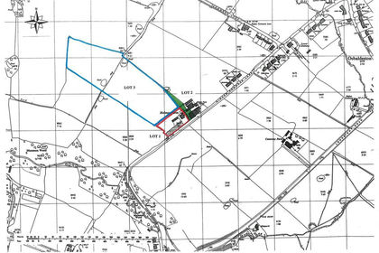
- Price
- Guide Price£175,000
- Size
- 8.27 acres
Higher Commons Lane (Lot 3), Balderstone, Blackburn, BB2, Balderstone, Lancashire BB2 England
Added on 10/08/2026Farmland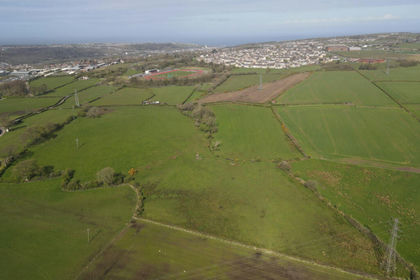
- Price
- Guide Price£175,000
- Size
- 34.71 acres
34 acres of Agricultural land at Hensingham, CA28, Whitehaven, Cumberland CA28 England
Added on 21/05/2026Agricultural Land