Ystumtuen, Aberystwyth, SY23
- Land size
- 10 acres
- Bedrooms
- 3
- Bathrooms
- 2
Key Features
- Ystumtuen Near Aberystwyth
- Traditional 3 bed character cottage
- Set in 10 acres of grounds
- Menage
- Outstanding views over the Cambrian Mountains
- Secluded yet not remote
- Range of useful outbuildings
- Enchanting gardens and grounds and woodland areas
Description
**Looking for a change of lifestyle amidst the beautiful welsh countryside, then look no further ! **A truly delightful 10 acre smallholding nested in the foothills of the Cambrian mountains**Attractive 3 bed traditional farmhouse full of charm and character**Breathtaking views over the Cambrian mountains**Range of useful outbuildings and stables**Perfect equestrian property with menage**Rural yet not remote setting being only a 20 minute drive from the county town of Aberystwyth**
The accommodation provides side hall, kitchen, utility room, dining room, study, lounge, living area, master bedroom with en suite. First floor - family bathroom and 2 bedrooms.
Troedyrhenrhiw stands in an elevated location in the foothills of the Cambrian mountains enjoying breathtaking views over the mountain range. Being ½ a mile from the main A44 mid wales trunk road with easy access into the sought after university and seaside resort of Aberystwyth with its wide range of amenities and employment opportunities. The property is close to many scenice walks and borders the common.
The property benefits from mains water and electricity. Private drainage to septic tank. Oil fired central heating system.
Council Tax Band -G (Ceredigion County Council).
Tenure - Freehold.
Side Hall
With quarry tiled floor. Panty cupboard off with plumbing for automatic washing machine.
Kitchen
11' 6" x 6' 3" (3.51m x 1.91m) being L shaped with fitted floor cupboards with oak worktops, Belfast sink with hot and cold taps, units for storage, quarry tiled flooring.
Utility Room
11' 9" x 5' 2" (3.58m x 1.57m) ‘L’ shaped, fitted floor and wall cupboards. Feature stone walls and tiled floor.
Dining Room
14' 0" x 9' 7" (4.27m x 2.92m) with flagstone floor, fireplace with log stove and built in cupboard. Exposed beams and understairs cupboard.
Front Entrance Hall and Porch
Housing electric meters.
Study
10' 1" x 6' 0" (3.07m x 1.83m) with no window, recessed shelves.
CONVERTED BARN
This was completed in 2003 to provides single storied additional accommodation incorporates as follows -
Lounge/Living Room
21' 4" x 14' 3" (6.50m x 4.34m) with attractive vaulted beamed ceiling to eaves. Stone feature fireplace with multifuel stove. French door to front elevation.
Master Bedroom
18' 1" x 14' 2" (5.51m x 4.32m) with laminate floor, radiator, vaulted ceiling. French doors to external veranda on northern elevation.
En Suite Shower Room
8' 2" x 8' 0" (2.49m x 2.44m) with low level flush w.c., pedestal wash hand basin, extractor fan, heated towel rail. Shower cubicle with shower unit.
Separate First Floor Accommodation
Accessed via the internal staircase from the hallway to a landing with steep staircase, the landing being galleried with access to an insulated loft area above.
Family Bathroom
8' 1" x 6' 9" (2.46m x 2.06m) refurbished in recent times with 3 piece suite comprising panelled bath, low level flush w.c., pedestal wash hand basin . Built in airing cupboard with electric immersion heater.
Bedroom 2
13' 7" x 7' 0" (4.14m x 2.13m) with radiator.
Bedroom 3
10' 4" x 6' 10" (3.15m x 2.08m) with radiator.
To the Front
The residence has an elevated site with fine view to the immediate south-east and is set off a quiet district lane with a gravelled path and with path leading down to the front of the property from the rear. There is parking for 2/3 vehicles at lane level.
To the front of the house is a raised patio which is gravelled and there are various lawned areas, with shrubs, mature hedges and trees.
A separate tarmacadamed service lane which is gated, leads to -
Menage
The ménage is a modern facility which is suiting those with equestrian needs, is level and provides additional equestrian appeal to the property with floodlighting, and incorporating post and rail fencing to the rubberised surface.
Stable Yard / Farm Buildings
The stable yard comprises as follows:-
Stable Block
34' 0" x 12' 0" (10.36m x 3.66m) utilised as such and garage workshop (34’x 12’) each of timber construction with corrugated asbestos dual pitched roof areas. Electricity connected.
Stone Barn
21' 0" x 16' 0" (6.40m x 4.88m) part clad with loft in part also.
Further Stone Range
40' 0" x 18' 0" (12.19m x 5.49m) with corrugated iron roof, located at the southernmost extremity of the property in an elvated site.
We believe this building had planning permission in the 1980's to convert into a residential property and we believe it still has potential subject to obtaining planning consent.
The Land
The land is fenced into a number of enclosures with mature trees, hedges, adequate shelter and is considered to be stock proof. There are a number of natural water supplies thereon.
The land and extent of the property is believed to be 10 acres or thereabouts.
MONEY LAUNDERING
The successful purchaser will be required to produce adequate identification to prove their identity within the terms of the Money Laundering Regulations. Appropriate examples include: Passport/Photo Driving Licence and a recent Utility Bill. Proof of funds will also be required, or mortgage in principle papers if a mortgage is required.
VIEWING ARRANGEMENTS
Strictly by prior appointment only. Please contact our Aberaeron Office on or
All properties are available to view on our Website – on our FACEBOOK Page - 'LIKE' our FACEBOOK Page for new listings, updates, property news and ‘Chat to Us’.
To keep up to date please visit our Website, Facebook and Instagram Pages
Map Location
Property details
- Tenure
- Freehold
- Council Tax Band
- G
- Date Posted
- 2026-05-21
Market Value Analysis
Compared with 221 Farms & Smallholdings listings in Wales (10+ acres).
Energy Performance Certificate
Energy Efficiency Rating
Based on UK Energy Performance Certificate standards (EU Directive 2002/91/EC)
Running costs are one side. Planning activity, flood history and ground risks for this location are in the full report.
Utilities & Restrictions
Utilities
- Electricity
- Mains
- Water
- Mains
- Heating
- Oil Heating
- Broadband
- Full Fibre (FTTP)
- Sewerage
- Septic Tank / Private
Rights & Restrictions
- Public Rights of Way
- Ask Agent
- Private Rights of Way
- Ask Agent
- Listed Property
- Ask Agent
- Restrictions
- Ask Agent
Listed status, conservation areas and planning constraints for this location are in the full report.
Property Features
- Accessibility
- Ask Agent
- Parking
- Garage, Driveway, Private Parking
- Garden
- Garden
Beyond the particulars: planning activity, flood history, heritage and ground risks, checked for this exact spot.
Connectivity
Broadband
Fastest speed available at this postcode
1.8 Gbps
Gigabit full fibre
Suitable for
- 4K streaming on every screen
- Full-time home working
- Online gaming & big downloads
Mobile signal
Predicted 4G and 5G signal; indoor signal depends on building materials.
Ofcom Connected Nations postcode-level predictions. Speeds and signal are modelled, not measured, and vary between addresses and providers.
Signal is the easy part. Planning activity, flood history and protected designations here are in the full report.
Nearest Schools
Primary
- Ysgol Gymunedol Syr John Rhys1.5 miles
- Pupils
- 15
- Type
- Infants & Juniors
- Language
- Welsh medium school / provision (including transitional)
- Ysgol Gymunedol Mynach1.6 miles
- Pupils
- 45
- Type
- Infants & Juniors
- Language
- Welsh medium school / provision (including transitional)
- Ysgol Gymunedol Llanfihangel-Y-Creuddyn4.9 miles
- Pupils
- 16
- Type
- Infants & Juniors
- Language
- Welsh medium school / provision (including transitional)
- Ysgol Penllwyn5.5 miles
- Pupils
- 42
- Type
- Infants & Juniors
- Language
- Welsh medium school / provision (including transitional)
- Ysgol Penrhyncoch6.7 miles
- Pupils
- 115
- Type
- Infants & Juniors
- Language
- Welsh medium school / provision (including transitional)
Secondary
- Penglais School8.8 miles
- Pupils
- 1,120
- Type
- Secondary (ages 11-19)
- Language
- English medium school / provision
- Ysgol Gyfun Penweddig9 miles
- Pupils
- 587
- Type
- Secondary (ages 11-19)
- Language
- Welsh medium school / provision (including transitional)
- Ysgol Henry Richard13 miles
- Pupils
- 387
- Type
- Middle (ages 3-16)
- Language
- Welsh medium school / provision (including transitional)
- Ysgol Bro Hyddgen14 miles
- Pupils
- 441
- Type
- Middle (ages 4-19)
- Language
- Welsh medium school / provision (including transitional)
- Llanidloes High School14 miles
- Pupils
- 703
- Type
- Secondary (ages 11-19)
- Language
- Dual language school / provision (Welsh and English) (including transitional)
Distances are straight-line from the advertised location. Source: the national school registers (DfE, Welsh Government, Scottish Government) and Ofsted.
Schools are just the start: sold prices nearby, planning activity and any flood history are in the full report.
Amenities
Supermarket
GP surgery
Pharmacy
Straight-line distances from the advertised location. Sources: NHS records, Geolytix supermarket locations, OS Open Greenspace and the national trails registers.
The area stacks up? Now check the location itself: planning nearby, protected designations and past flooding.
Getting Around
Nearest station
Nearest bus stop
Typical drive times
Straight-line distances from the advertised location; drive times are typical free-flow times over OpenStreetMap road data, so allow more at peak. Public transport locations from DfT NaPTAN.
Easy to reach matters. So do planning activity, flood history and ground risks: all in the full report.
Flood Risk
Natural Resources Wales open data, checked around the advertised map pin for the listed acreage. Long-term risk counts flood defences; the planning map's flood zones do not. The map pin for this listing marks the postcode area rather than the exact location, so these readings describe the surrounding area. Provided by LandSale, not the listing agent, and not part of the agent's particulars. Risk varies across a holding, so verify before committing.
Rivers and the sea
Planning map: Flood Zone 1.
Surface water
Not at the pin: mapped about 10 metres away.
These bandings are the summary. Where this location sits on the flood maps, plus planning activity, heritage and ground risks, is in the full report.
Important notice: Information, maps and tags on this page are drawn from the advertising agent's marketing materials or generated automatically. LandSale has not verified them. Relying on these details is at your own risk, always carry out independent checks before committing to a purchase.
LandSale full disclaimer
Marketing information only - not formal particulars. The details on this website are provided for general guidance and do not constitute an offer or contract. Neither LandSale nor the advertising estate/land agent accepts responsibility for any inaccuracy.
1. Source of information
- Listing content: Core description, asking price, tenure, measurements, photographs and planning history originate from the marketing materials of the advertising estate or land agent. LandSale does not author this content and cannot guarantee its accuracy.
- Automated tags & categorisation: Property type, land-use class, acreage bands and similar labels may be applied by machine-learning models. They are intended as a helpful guide only and may not reflect the property's legal status or permitted use.
- Third-party & enriched data layers: Maps, boundary outlines, planning designations, soil reports, broadband coverage and other environmental or location-based insights are licensed from external suppliers. Such data are supplied “as is", may be incomplete or out of date and are subject to change without notice.
2. Verification required
Prospective purchasers must verify critical matters, including but not limited to planning permission, title boundaries, public rights of way, environmental constraints, acreage, services, access and VAT status, through their own inspections, specialist surveys, legal advisers and the selling agent before relying on the information or entering into any contract.
3. No warranty or liability
LandSale gives no warranty, express or implied, as to the accuracy, completeness or fitness for any particular purpose of the information displayed. LandSale shall not be liable for any loss, damage, cost or expense arising directly or indirectly from any use of or reliance on such information, save where liability may not be excluded by law.
4. Updates & feedback
If you believe any detail on this listing is inaccurate, please let us know. We will investigate and, where appropriate, update the listing or notify the agent.
© LandSale | Version 1.3 - August 2026
Similar properties for sale
- Price
- £525,000
- Size
- 6 acres
Added on 06/05/2026Smallholding
- Price
- Guide Price£535,000
- Size
- 55.1 acres
Devils Bridge, Aberystwyth, Pontarfynach, Ceredigion SY23 Wales
Added on 29/01/2026Farm
- Price
- Guide Price£585,000
- Size
- 29 acres
Added on 08/08/2026Smallholding
- Price
- Guide Price£595,000
- Size
- 8 acres
Added on 29/01/2026Smallholding
- Price
- £595,000
- Size
- 34 acres
Trefenter, Aberystwyth, SY23, Llangwyryfon, Ceredigion SY23 Wales
Added on 29/01/2026Smallholding
- Price
- £425,000
- Size
- 6 acres
Llanddewi Brefi, Tregaron, SY25, Llanddewi Brefi, Ceredigion SY25 Wales
Added on 15/09/2026Smallholding
- Price
- Guide Price£549,995
- Size
- 7.11 acres
Llidiartywaun, Llanidloes, Powys, SY18, Llandinam, Powys SY18 Wales
Added on 22/05/2026House with Land
- Price
- £480,000
- Size
- 5.23 acres
Abermeurig, Lampeter, SA48, Nantcwnlle, Ceredigion SA48 Wales
Added on 02/10/2026Smallholding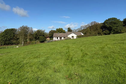
- Price
- £595,000
- Size
- 30 acres
Bettws Bledrws, Lampeter, SA48, Llangybi, Ceredigion SA48 Wales
Added on 07/10/2026Smallholding
- Price
- Guide Price£590,000
- Size
- 58 acres
Neuaddlwyd, Aberaeron, SA48, Ciliau Aeron, Ceredigion SA48 Wales
Added on 29/01/2026Smallholding