Cottingham Street, Goole, East Riding of Yorkshire, DN14
- Land size
- 4.53 acres
- Bedrooms
- 4
Key Features
- Late 18th Century Farmhouse
- Range of historically important traditional farm buildings
- Grass paddock of 2.3 acres or thereabouts
- Total area of 4.53 acres or thereabouts
- Grade II Listed
- House in need of significant modernisation
Description
History
Bridge Farmhouse in Goole is a Grade II listed property dating from the late eighteenth century (listed in 1987).
The building, together with its associated farm structures, forms part of an unusually complete and wellpreserved
agricultural complex that illustrates the area's pre-industrial character and its subsequent
transition into an industrial port settlement.
Goole originated as a small, sparsely populated rural settlement centred on the junction of the Dutch River
and the River Ouse. Prior to the nineteenth century, the surrounding landscape consisted primarily of
farmland interspersed with isolated dwellings. Bridge Farm formed part of this early agricultural setting,
located close to a crossing of the Dutch River, a feature that influenced the development of what became
known as “Old Goole.” The transformation of Goole in the nineteenth century was driven by the development
of the Aire and Calder Navigation docks, which established the town as a significant inland port. As industrial
and urban development expanded, former agricultural land around Old Goole—including Bridge Farm—was
progressively enclosed by housing, industry, and transport infrastructure. The survival of Bridge Farm within
this altered context illustrates the encroachment of urbanisation onto an earlier rural landscape.
The farmhouse is constructed of brick laid in Flemish bond and displays characteristics of Georgian
architecture, reflecting the modest prosperity of late eighteenth-century farming in the region. Internally, the
building retains notable historic features and these elements contribute to the building's special architectural
interest
The farmhouse is complemented by a range of late eighteenth-century agricultural buildings, largely
constructed in brick laid in English garden wall bond. Together they form a coherent and largely intact
farmstead group of considerable historic interest:
Bridge Farmhouse and its associated buildings are significant as a rare survival of an integrated late
eighteenth-century farmstead within an urban-industrial context. The group retains strong architectural
coherence and evidences traditional construction techniques, including varied brick bonding patterns and
functional agricultural forms.
Historically, the site provides valuable insight into the agricultural origins of Goole and its’ rapid transformation during the nineteenth century into a major inland port. The
juxtaposition of the farm complex with later industrial and residential development highlights the broader pattern of landscape change and urban expansion. As such, Bridge Farm
represents an important tangible link to the early development of Goole, preserving both its rural heritage and its role within the town's evolving historical narrative.
Introduction
Dating from the late 18th Century Bridge Farm, Goole, offers a rare opportunity to purchase a
Grade II Listed 4 bedroom detached farmhouse with many period features in all extending to
4.50 acres, or thereabouts. The property boast a range of Grade II Listed Buildings together
with orchard and gardens.
Requiring complete refurbishment, this characterful farmhouse presents an outstanding
opportunity to create a beautiful and highly personalised residence. The Farmhouse
principally comprises 2 reception rooms, kitchen, dairy, dining room, 4 bedrooms, bathroom, 3
attic rooms and cellars.
Location
From Goole Town centre take A161 Bridge Street towards Swinefleet. After passing the third
bridge turn right into Cottingham Street where the driveway to Bridge Farm will be found on
the right hand side.
Goole has a good selection of amenities and is ideally placed for the Cities of Hull, York and
Leeds with Junction 36 of the M62 motorway being within 3 miles and allows easy access to the
major Yorkshire Business Centres.
What3Words - ///foresight.perplexed.workbench
Oustside
The sweeping drive off Cottingham Street leads to gardens laid to lawn and access to the house
and farm buildings. There is a semi-walled garden to the side of the house, a small rectangular
formal garden to the front and Orchard to the rear.
Energy Performance Certificate
The EPC rating is “G“.
Services
Mains services of water, gas, drainage and electricity are installed. The house benefits from a
gas boiler for hot water, but there is no central heating. None of the services or associated
appliances have been checked or tested.
Council Tax
We have been advised the property is Council Tax Band E, payable to the East Riding of
Yorkshire Council.
RED BRICK BUILDINGS (All with electric lights and sockets and 3 phase supply)
to Buildings 7 & 8)
Building 1
A) 22'6" x 15'5" (6.86m x 4.7m) with toilet and washing facilities.
B) 15'2" x 10’1" (4.62m x 3.07m).
Building 2
A) 15'2" x 12'9" (4.62m x 3.89m) with ground level feeding trough.
B) 15'2 x 6' (4.62m x 1.83m).
C) 15'2" x 12'4" (4.62m x 3.76m) with feeding trough.
Stairs between Buildings 2 and 3 leading to second floor of Building 2.
Building 3
With passage leading to under stairs storage behind 24'2" x 4'9 (7.37m x 1.45m).
A) Ground Floor 24'2" x 14'4" (7.37m x 4.37m).
B) 24'2" x 20' ( 7.37m x 6.1m) with loft hatch to:
C) Pigeon Loft 24'2" x 20" ( 7.37m x 6.1m) with pigeon houses.
Building 4 - 51'4" x 13'2" (16.48m x 4.01m) - open fronted cart shed with round
brick pillars.
Building 5 -10'3" x 13'2"(3.12m x 4.01m) - one bay Garage.
Building 6 - 13'2" x 41'2" (4.01m x 12.55m) - open fronted cart shed with round
brick pillars and wooden lean-to.
Building 7
A) 45'7" x 21' ( 13.89m x 6.4m) 2 storey with double barn doors to
frontage.
B) 2 storey with double barn doors to yard.
Building 8 - 24'3" x 62' (7.39m x 18.9m) 2 storey with double barn doors to
frontage and yard with pedestrian door to yard.
Building 9 - one storey with pedestrian doors to yard and frontage.
(A) 19' x 21'9" (5.79m x 6.63m)
(B) 39'1 x 21'9" (11.91m x 6.63m)
(C) 9'8" x 21'9" (2.95 x 6.63m)
Building 10
Two bay open fronted General Purpose Building - 22' x 32' (6.71m x 9.75m)
having steel stanchions to front, timber frame and block walls.
Building 11
Brick Built Workshop - 10'4" x 14'6" (3.15m x 4.42m) accessed from the yard.
Building 12
Brick Built Garden Outbuilding - 10'9" x 13'5" (3.28m x 4.09m) accessed from
the house and lawn.
Fixtures & Fittings
Those items mentioned in these particulars are included in the freehold sale. All other fixtures, fittings and furnishings are expressly excluded.
Planning Potential
A pre-application was submitted to East Riding of Yorkshire Council in late 2025 in respect of the farm buildings. We have been informally advised by EYRC that: a)due to the
property being in flood zone 3, any application for residential development will be refused, b) they are very keen to see the site preserved and would look sympathatically at other
uses in classes B2, B8 and E (subject to planning).
Wayleaves, Easements and Rights of Way
The Property is sold subject to all rights of way, reservation of minerals, water, drainage, sporting rights, other easements and wayleaves and all rights of access, whether mentioned
in these particulars or not.
Value Added Tax (VAT)
The sale price is agreed on a VAT exclusive basis and the Purchaser(s) shall indemnify the Vendor for any VAT which may be subsequently payable.
Tenure & Possession
The property is for sale freehold with vacant possession.
Plan
The property is shown on the attached plan edged red for identification purposes only.
Offer Procedure
If you are interested in this Property and wish to make an Offer then this should be made to DDM Agriculture. I would point out that under the Estate Agency Act 1991, you will be
required to provide us with the relevant Financial Information for us to verify your ability to proceed with the purchase, before we can recommend your Offer to the Vendor. It will
also be necessary for you to provide Proof of Identification in order to adhere to Money Laundering Regulations.
Viewings
If you require any further information or wish to view this property please contact the Selling Agents, DDM Agriculture
Map Location
Property details
- Tenure
- Freehold
- Council Tax Band
- E
- Date Posted
- 2026-05-20
Market Value Analysis
Compared with 668 Homes with Land listings in Yorkshire and The Humber (1+ acres).
Energy Performance Certificate
Energy Efficiency Rating
Based on UK Energy Performance Certificate standards (EU Directive 2002/91/EC)
Running costs are one side. Planning activity, flood history and ground risks for this location are in the full report.
Utilities & Restrictions
Utilities
- Electricity
- Mains
- Water
- Mains
- Heating
- Ask Agent
- Broadband
- Ask Agent
- Sewerage
- Mains
Rights & Restrictions
- Public Rights of Way
- Ask Agent
- Private Rights of Way
- Ask Agent
- Listed Property
- Yes
- Restrictions
- Ask Agent
Listed status, conservation areas and planning constraints for this location are in the full report.
Property Features
- Accessibility
- Ask Agent
- Parking
- Parking Available
- Garden
- Garden
Beyond the particulars: planning activity, flood history, heritage and ground risks, checked for this exact spot.
Connectivity
Broadband
Fastest speed available at this postcode
1.8 Gbps
Gigabit full fibre
Suitable for
- 4K streaming on every screen
- Full-time home working
- Online gaming & big downloads
Fixed wireless access may also be an option here.
Mobile signal
Predicted 4G and 5G signal; indoor signal depends on building materials.
Ofcom Connected Nations postcode-level predictions. Speeds and signal are modelled, not measured, and vary between addresses and providers.
Signal is the easy part. Planning activity, flood history and protected designations here are in the full report.
Nearest Schools
Primary
- Marshlands Primary School657 metresOfsted: Good
- Ages
- 3 to 11
- Pupils
- 221
- Type
- Community school
- Boothferry Primary School0.8 milesOfsted: Good
- Ages
- 3 to 11
- Pupils
- 389
- Type
- Community school
- St Joseph's Catholic Primary School Goole0.9 milesOfsted: Good
- Ages
- 3 to 11
- Pupils
- 102
- Type
- Academy converter
- Faith
- Roman Catholic
- Kingsway Primary School1.1 milesNo Ofsted rating
- Ages
- 3 to 11
- Pupils
- 383
- Type
- Community school
- Parkside Primary School1.4 milesOfsted: Good *
- Ages
- 3 to 11
- Pupils
- 408
- Type
- Community school
Secondary
- Goole Academy1 mileOfsted: Good
- Ages
- 11 to 16
- Pupils
- 1,348
- Type
- Academy converter
- Howden School3.8 milesOfsted: Good *
- Ages
- 11 to 16
- Pupils
- 699
- Type
- Academy converter
- Trinity Academy6.5 milesOfsted: Good
- Ages
- 11 to 18
- Pupils
- 1,176
- Type
- Academy sponsor led
- Faith
- Christian
- The Snaith School6.6 milesOfsted report card · May 2026
- Ages
- 11 to 16
- Pupils
- 837
- Type
- Academy converter
- The Axholme Academy6.9 milesOfsted: Good
- Ages
- 11 to 16
- Pupils
- 518
- Type
- Academy converter
* Latest graded judgement covers quality of education only; no overall grade was issued under the 2024-25 inspection framework.
Distances are straight-line from the advertised location. Source: the national school registers (DfE, Welsh Government, Scottish Government) and Ofsted.
Schools are just the start: sold prices nearby, planning activity and any flood history are in the full report.
Amenities
Supermarket
GP surgery
Pharmacy
Hospital
Green space
Straight-line distances from the advertised location. Sources: NHS records, Geolytix supermarket locations, OS Open Greenspace and the national trails registers.
The area stacks up? Now check the location itself: planning nearby, protected designations and past flooding.
Getting Around
Nearest station
Nearest bus stop
Typical drive times
Straight-line distances from the advertised location; drive times are typical free-flow times over OpenStreetMap road data, so allow more at peak. Public transport locations from DfT NaPTAN.
Easy to reach matters. So do planning activity, flood history and ground risks: all in the full report.
Flood Risk
Environment Agency open data, checked around the advertised map pin for the listed acreage. Long-term risk counts flood defences; the planning map's flood zones do not. Provided by LandSale, not the listing agent, and not part of the agent's particulars. Risk varies across a holding, so verify before committing.
Rivers and the sea
Not at the pin: mapped about 60 metres away.
Planning map: Flood Zone 3.
Surface water
Not at the pin: mapped about 40 metres away.
These bandings are the summary. Where this location sits on the flood maps, plus planning activity, heritage and ground risks, is in the full report.
Important notice: Information, maps and tags on this page are drawn from the advertising agent's marketing materials or generated automatically. LandSale has not verified them. Relying on these details is at your own risk, always carry out independent checks before committing to a purchase.
LandSale full disclaimer
Marketing information only - not formal particulars. The details on this website are provided for general guidance and do not constitute an offer or contract. Neither LandSale nor the advertising estate/land agent accepts responsibility for any inaccuracy.
1. Source of information
- Listing content: Core description, asking price, tenure, measurements, photographs and planning history originate from the marketing materials of the advertising estate or land agent. LandSale does not author this content and cannot guarantee its accuracy.
- Automated tags & categorisation: Property type, land-use class, acreage bands and similar labels may be applied by machine-learning models. They are intended as a helpful guide only and may not reflect the property's legal status or permitted use.
- Third-party & enriched data layers: Maps, boundary outlines, planning designations, soil reports, broadband coverage and other environmental or location-based insights are licensed from external suppliers. Such data are supplied “as is", may be incomplete or out of date and are subject to change without notice.
2. Verification required
Prospective purchasers must verify critical matters, including but not limited to planning permission, title boundaries, public rights of way, environmental constraints, acreage, services, access and VAT status, through their own inspections, specialist surveys, legal advisers and the selling agent before relying on the information or entering into any contract.
3. No warranty or liability
LandSale gives no warranty, express or implied, as to the accuracy, completeness or fitness for any particular purpose of the information displayed. LandSale shall not be liable for any loss, damage, cost or expense arising directly or indirectly from any use of or reliance on such information, save where liability may not be excluded by law.
4. Updates & feedback
If you believe any detail on this listing is inaccurate, please let us know. We will investigate and, where appropriate, update the listing or notify the agent.
© LandSale | Version 1.3 - August 2026
Listing agent
DDM Agriculture, Brigg
Eastfield Albert Street, Brigg, DN20 8HS
Similar properties for sale
- Price
- Guide Price£950,000
- Size
- 2.99 acres
Cottage Farmstead, Crowle, North Lincs, Crowle and Ealand, North Lincolnshire DN17 England
Added on 29/01/2026Development Land
- Price
- Guide Price£810,000
- Size
- 3.3 acres
Swanland, South End, Thorne, Doncaster, Thorne, Doncaster DN8 England
Added on 15/09/2026Fishery
- Price
- Offers in Region of£795,000
- Size
- 7 acres
Sykehouse SOUTH YORKSHIRE, Sykehouse, Doncaster DN14 England
Added on 08/10/2026House with Land
- Price
- Offers in Region of£900,000
- Size
- 5.5 acres
Added on 29/01/2026House with Land
- Price
- Offers Over£700,000
- Size
- 2.74 acres
Camblesforth Road, Selby, Camblesforth, North Yorkshire YO8 England
Added on 30/07/2026House with Land
- Price
- £900,000
- Size
- 2.15 acres
Added on 17/08/2026House with Land
- Price
- Guide Price£999,000
- Size
- 2 acres
Sand Pit Lane, Scunthorpe, DN15, Alkborough, North Lincolnshire DN15 England
Added on 27/03/2026Residential
- Price
- Guide Price£995,000
- Size
- 9 acres
Grange Farm, Broomfleet, East Yorkshire, Broomfleet, East Riding of Yorkshire HU15 England
Added on 25/06/2026Farmhouse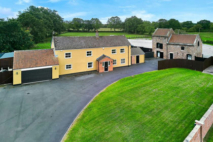
- Price
- Offers in Excess of£1,000,000
- Size
- 3 acres
West End Cottage & The Dovecote, Sykehouse, Sykehouse, Doncaster DN14 England
Added on 01/10/2026Farmhouse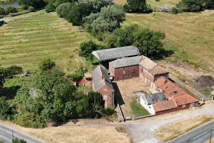
- Price
- Offers Over£800,000
- Size
- 17 acres
Kirkhouse Green, Nr Fishlake, Doncaster, DN7, Kirk Bramwith, Doncaster DN7 England
Added on 20/07/2026House with Land