Buildings At King's Ride Farm, Alfriston
Description
Redevelopment of a redundant farmyard into seven residential dwellings
A rare opportunity to acquire a bespoke 7 dwelling residential scheme located within the South Downs National Park.Planning has been secured under reference No.SDNP/23/03986/FUL for the reuse and redevelopment of the existing agricultural buildings in order to create a landscape-led scheme replicating the farmstead layout.
Offers in the region of £950,000-£1,100,000
Situation
The existing range of farm buildings is situated on the southwestern edge of the village of Alfriston, one of the South Downs’ most sought after and characterful villages. Alfriston provides an excellent range of fine dining venues including The Star as well as the recently refurbished Alfriston Spa Hotel. The village also provides an excellent primary school and doctors surgery.
The village sits within the scenic Cuckmere valley with miles of downland countryside to the west providing wonderful outdoor recreational opportunities.
Berwick station is only about 2 miles distant with mainline rail services running to London Victoria and Gatwick Airport. Sporting facilities in the area include 3 principal golf courses at Eastbourne as well as tennis at The David Lloyd Club.
There is world class opera at nearby Glyndebourne and channel ferries operate from Newhaven.
The site occupies a transitional position between existing development to the east and open countryside to the west and the south. The site benefits from extensive views across downland farmland.
Access and Connectivity
The site will utilise the existing access to the farm buildings directly from King’s Ride via an access point in the northeastern corner of the site.
The site benefits from access directly onto the South Downs Way National Trail which runs between Winchester in the west and Eastbourne in the east, together with easy access to the Cuckmere Valley and coastal landscape.
Existing Buildings
The site currently comprises of three existing agricultural structures.
• A grain store constructed using At-Cost precast concrete frame with brick base, part larch cladding and cement sheet roof located to the west of the site.
• A masonry brick pig shed with concrete lintels, steel windows and cement sheet roof located directly to the west of the grain store.
• A masonry brick chicken shed located to the north of the site bordering King’s Ride.
Planning
The site was identified within Policy SD28 of the South Downs Local Plan as being suitable for delivering 6 to 8 residential dwellings. A pre application meeting with the South Downs National Park (SDNP) was first held in 2018 and since that date there has been two previous schemes presented to the SDNP Design Review Panels.
Throughout this process the architects have sought to bring forward a landscape led scheme that combines rural architecture, sustainability and strong placemaking credentials.
The former farmyard will accommodate the new residential uses, whilst seeking to retain a character which is more ‘farmyard’ and less residential in nature. In order to improve the sustainability of the scheme the design has incorporated the retention and reuse of existing structures, homes designed to Passivhaus
principles, air source heat pumps and photovoltaic panels and electric vehicle charging provisions.
Planning was granted on 24th February 2026 subject to the discharging of conditions prior to the commencement of development. These include but are not limited to confirming the architectural details of the scheme and the materials and finishes together with landscaping.
Accommodation
The ‘Barn’ building is set on the footprint of the existing Grain Store and will accommodate 6 dwellings with a detached ‘farmhouse’ set in the lower southern end of the site.
In each proposed unit layout, the bedrooms are situated on the ground floor along with one bathroom in order to provide accessible living in the long term.
On the first floor, each unit has a living space, dining space, kitchen, bathroom and utility. Each unit has access to a private external garden as well as the shared yard at the centre of the scheme.
Four units in the barn have access to a private winter garden which can be accessed at both ground floor and first floor level. The ‘farmhouse’ unit also has access to a private courtyard which is enclosed by the existing pig shed wall.
Data Room
As part of this sale a password protected data room containing additional information has been prepared. Access can be provided upon request.
Tenure
The freehold is being sold with vacant possession upon completion.
Section 106
A Section 106 agreement is in place between the Vendor and the South Downs National Park Authority. Contributions are required for Monitoring contributions (£1,320). The agreement also stipulates the requirement for two affordable
housing units.
Retained Land
The vendor will be retaining part of Title No. ESX255803.
Method of Sale
We are seeking offers on a unconditional basis for the freehold interest of the site. Offers should be for a fixed amount and unrelated to any other offer. The vendors retain the right not to accept the highest or indeed any offer.
When submitting your offer please provide the following information:
• Confirmation of how the purchase is to be funded.
• Whether board approval is required and if so whether it has been sought prior to the submission of the offer.
• Confirmation that the planning application has been taken into account.
• The amount of deposit being offered along with any conditions.
• Solicitors acting in the transaction.
Offers will be deemed to have been made with full consideration of the information available within the data room and the South Downs National Park
Viewing Arrangements:
For an appointment to view the site please contact
Oliver Robinson MRICS
Tel:
Mob:
Email: o.
planning portal
Map Location
Property details
- Tenure
- Ask Agent
- Council Tax Band
- TBC
- Date Posted
- 2026-05-14
Utilities & Restrictions
Utilities
- Electricity
- Ask Agent
- Water
- Ask Agent
- Heating
- Ask Agent
- Broadband
- Ask Agent
- Sewerage
- Ask Agent
Rights & Restrictions
- Public Rights of Way
- Ask Agent
- Private Rights of Way
- Ask Agent
- Listed Property
- Ask Agent
- Restrictions
- Ask Agent
Listed status, conservation areas and planning constraints for this location are in the full report.
Property Features
- Accessibility
- Ask Agent
- Parking
- Ask Agent
- Garden
- Garden
Beyond the particulars: planning activity, flood history, heritage and ground risks, checked for this exact spot.
Connectivity
Broadband
Fastest speed available at this postcode
75 Mbps
Superfast
Suitable for
- HD streaming
- Video calls
- Web & social
Mobile signal
Predicted 4G and 5G signal; indoor signal depends on building materials.
Ofcom Connected Nations postcode-level predictions. Speeds and signal are modelled, not measured, and vary between addresses and providers.
Signal is the easy part. Planning activity, flood history and protected designations here are in the full report.
Nearest Schools
Primary
- Alfriston School467 metresOfsted: Outstanding *
- Ages
- 5 to 11
- Pupils
- 85
- Type
- Community school
- Chyngton School2.2 milesOfsted report card · Feb 2026
- Ages
- 2 to 11
- Pupils
- 332
- Type
- Academy converter
- Cradle Hill Community Primary School2.3 milesNo Ofsted rating
- Ages
- 2 to 11
- Pupils
- 661
- Type
- Community school
- Seaford Primary School2.9 milesOfsted report card · May 2026
- Ages
- 4 to 11
- Pupils
- 393
- Type
- Community school
- Annecy Catholic Primary School3 milesOfsted: Good
- Ages
- 4 to 11
- Pupils
- 189
- Type
- Academy converter
- Faith
- Roman Catholic
Secondary
- Seaford Head School2.9 milesNo Ofsted rating
- Ages
- 11 to 18
- Pupils
- 1,461
- Type
- Academy converter
- Willingdon Community School3.9 milesNo Ofsted rating
- Ages
- 11 to 16
- Pupils
- 1,117
- Type
- Community school
- Ratton School4.8 milesOfsted report card · May 2026
- Ages
- 11 to 16
- Pupils
- 1,183
- Type
- Academy converter
- Seahaven Academy5 milesOfsted report card · Nov 2025
- Ages
- 11 to 16
- Pupils
- 701
- Type
- Academy sponsor led
- The Cavendish School5.1 milesOfsted: Outstanding *
- Ages
- 2 to 16
- Pupils
- 1,399
- Type
- Academy converter
* Latest graded judgement covers quality of education only; no overall grade was issued under the 2024-25 inspection framework.
Distances are straight-line from the advertised location. Source: the national school registers (DfE, Welsh Government, Scottish Government) and Ofsted.
Schools are just the start: sold prices nearby, planning activity and any flood history are in the full report.
Amenities
Supermarket
GP surgery
Pharmacy
Hospital
Green space
Walking trail
Straight-line distances from the advertised location. Sources: NHS records, Geolytix supermarket locations, OS Open Greenspace and the national trails registers.
The area stacks up? Now check the location itself: planning nearby, protected designations and past flooding.
Getting Around
Nearest station
Nearest bus stop
Typical drive times
Straight-line distances from the advertised location; drive times are typical free-flow times over OpenStreetMap road data, so allow more at peak. Public transport locations from DfT NaPTAN.
Easy to reach matters. So do planning activity, flood history and ground risks: all in the full report.
Flood Risk
Environment Agency open data, checked around the advertised map pin for the listed acreage. Long-term risk counts flood defences; the planning map's flood zones do not. Provided by LandSale, not the listing agent, and not part of the agent's particulars. Risk varies across a holding, so verify before committing.
Rivers and the sea
Planning map: Flood Zone 1.
Surface water
These bandings are the summary. Where this location sits on the flood maps, plus planning activity, heritage and ground risks, is in the full report.
Important notice: Information, maps and tags on this page are drawn from the advertising agent's marketing materials or generated automatically. LandSale has not verified them. Relying on these details is at your own risk, always carry out independent checks before committing to a purchase.
LandSale full disclaimer
Marketing information only - not formal particulars. The details on this website are provided for general guidance and do not constitute an offer or contract. Neither LandSale nor the advertising estate/land agent accepts responsibility for any inaccuracy.
1. Source of information
- Listing content: Core description, asking price, tenure, measurements, photographs and planning history originate from the marketing materials of the advertising estate or land agent. LandSale does not author this content and cannot guarantee its accuracy.
- Automated tags & categorisation: Property type, land-use class, acreage bands and similar labels may be applied by machine-learning models. They are intended as a helpful guide only and may not reflect the property's legal status or permitted use.
- Third-party & enriched data layers: Maps, boundary outlines, planning designations, soil reports, broadband coverage and other environmental or location-based insights are licensed from external suppliers. Such data are supplied “as is", may be incomplete or out of date and are subject to change without notice.
2. Verification required
Prospective purchasers must verify critical matters, including but not limited to planning permission, title boundaries, public rights of way, environmental constraints, acreage, services, access and VAT status, through their own inspections, specialist surveys, legal advisers and the selling agent before relying on the information or entering into any contract.
3. No warranty or liability
LandSale gives no warranty, express or implied, as to the accuracy, completeness or fitness for any particular purpose of the information displayed. LandSale shall not be liable for any loss, damage, cost or expense arising directly or indirectly from any use of or reliance on such information, save where liability may not be excluded by law.
4. Updates & feedback
If you believe any detail on this listing is inaccurate, please let us know. We will investigate and, where appropriate, update the listing or notify the agent.
© LandSale | Version 1.3 - August 2026
Listing agent
Batcheller Monkhouse Professional, Tunbridge Wells
1 London Road, Tunbridge Wells, TN1 1DH
Contact Batcheller Monkhouse Professional, Tunbridge Wells
1 London Road, Tunbridge Wells, TN1 1DH
View agent profileSimilar properties for sale
- Price
- £1,000,000
Added on 21/09/2026Development Land Added on 29/01/2026Development Land
- Price
- Guide Price£950,000
7-9 West Street, Lewes, East Sussex, BN7, Lewes, East Sussex BN7 England
Added on 03/06/2026Development Land
- Price
- Guide Price£850,000
- Size
- 1.7 acres
Dern Lane, Waldron, East Sussex, TN21, Heathfield and Waldron, East Sussex TN21 England
Added on 29/01/2026Development Land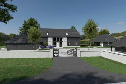
- Price
- Guide Price£875,000
- Size
- 2 acres
Palehouse Common, Framfield, East Sussex, TN22, Framfield, East Sussex TN22 England
Added on 29/01/2026Building Plot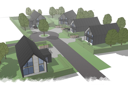 Added on 18/06/2026Development Land
- Price
- Guide Price£725,000
- Size
- 0.36 acres
Added on 12/07/2026Building Plot
- Price
- Guide Price£800,000
- Size
- 0.5 acres
Warren Lane, North Chailey, Lewes, BN8, Chailey, East Sussex BN8 England
Added on 09/08/2026Development Land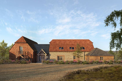
- Price
- £850,000
- Size
- 3.7 acres
Single Plot at Swife Lane, Broad Oak, TN21, Heathfield and Waldron, East Sussex TN21 England
Added on 23/07/2026Self Build Plot
- Price
- Offers in Excess of£800,000
- Size
- 1.71 acres
Sayers Common, Hurstpierpoint and Sayers Common, West Sussex BN6 England
Added on 28/01/2026Development Land