Colne Engaine, Halstead
- Land size
- 11.1 acres
Key Features
- Permitted Development Confirmed
- 4 Residential Units
- Total Plot of 11 acres
- Scope for Alternative Development (subejct to consents)
- Countryside Location
- Smallholding Opportunity
Description
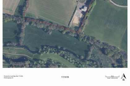
Mill View Paddock is located in tranquil countryside surrounded by mature hedges with views over surrounding countryside.
The site adjoins the Mill Lane and extends in all to approximately 11.10 acre / 4.49 ha.
The land is laid to grass pasture with mature hedges and internal fencing. The modern farm building has permitted development for conversion to 4 dwellings, a further agricultural building is consented with footings commenced.
The buildings and site may hold potential, subject to planning, for alternative development, such as independent residential units or commercial uses.
Adjoining land is available by separate negotiation.
The land is located adjacent to Mill Lane between White Colne and Colne Engaine.
Earls Colne is approximately 1km to the south, Halstead 5km to the west with access to the A12 at Stanway approximately 10km to the east.
What3words:
Nearest Postcode: CO6 2HX
The existing steel framed farm building has prior approval for conversion to 4 dwellings offer accomodation as follows:
Dwelling #1 148.8sqm / 1601sqft
- Living Room, Kitchen, Utility &WC to the ground floor with 3 bedrooms and bathroom on the 1st floor
Dwelling #2 148.8sqm / 1601sqft
- Living Room, Kitchen, Utility &WC to the ground floor with 3 bedrooms and bathroom on the 1st floor
Dwelling #3 114sqm / 1227sqft
- Living Room, Kitchen, Utility &WC to the ground floor with 3 bedrooms and bathroom on the 1st floor
Dwelling #4 114sqm / 1227sqft
- Living Room, Kitchen, Utility &WC to the ground floor with 3 bedrooms and bathroom on the 1st floor
A total development of approximately 525.6sqm / 5656sqft.
Also on the site is an incomplete farm building. This is consented under planning reference 10/00716/FUL and has been implemented but not completed. The consented farm building would be extend to approximately 445sqm / 4,800sqft.
The local planning authority is Braintree District Council.
The planning history is listed as:
14/00025/FUL - Erection of general purpose agricultural building, access track and farmyard. Status: Application Permitted
14/00091/DAC - Application for approval of details reserved by condition no. 5 of approved application 14/00025/FUL. Status: Application Permitted
14/01127/HDG - Notice of intent to carry out works to a hedge - Remove 10 metres of hedge. Status: Application Permitted
19/00716/FUL - Agricultural barn and associated hard standing. Status: Application Permitted
23/02740/AGR - Application for prior notification of agricultural or forestry development - to all weather surface existing agricultural grass track. Permission / Approval Not Required
24/02188/COUPA - Prior approval for the change of use of agricultural building to a dwelling house (Class C3), and for associated operational development - Change of use to 4 No. residential dwellings. Status: Prior Approval Required and Given
25/00461/FUL - Formation of new all weather agricultural vehicular access. Status: Application Withdrawn.
Purchasers must satisfy themselves as to the relevant town planning consents and conditions.
Purchasers to make their own enquiries as to the availability of services.
The property is accessed via double field gates over a drive directly from the highway. A right of way for all purposes at all times will be granted over the driveway to the site, subject to the purchaser paying a reasonable proportion towards maintenance and renewal.
The property is sold subject to any easements, quasi easements, wayleaves, rights of way or obligations whether mentioned in these particulars or not.
Strictly by appointment Viewing of the property is entirely at the risk of the enquirer. Neither Whirledge & Nott nor the Vendor accept any responsibility for any damage, injury or accident during viewing.
The purchaser will be required to provide proof of identity and address prior to solicitors being instructed.
The property is offered for sale by auction on 4th June 2026, unless sold prior. A legal pack is available via joint auctioneers Dedman Gray.
Whirledge & Nott does not have any authority to give representations or warranties in relation to the property. These particulars do not form part of any offer or contract. All descriptions, photographs and plans are for guidance only and should not be relied upon as statements or representations of fact. All measurements are approximate. No assumption should be made that the property has the necessary planning, building regulations or other consents. Whirledge & Nott has not carried out a survey nor tested any appliances, services or facilities. Purchasers must satisfy themselves by inspection or otherwise.
Map Location
Property details
- Tenure
- Freehold
- Council Tax Band
- Ask Agent
- Date Posted
- 2026-05-12
Market Value Analysis
Compared with 67 Farmland & Pasture listings in East Anglia (10+ acres).
Utilities & Restrictions
Utilities
- Electricity
- Ask Agent
- Water
- Ask Agent
- Heating
- Ask Agent
- Broadband
- Ask Agent
- Sewerage
- Ask Agent
Rights & Restrictions
- Public Rights of Way
- Ask Agent
- Private Rights of Way
- Ask Agent
- Listed Property
- Ask Agent
- Restrictions
- Ask Agent
Property Features
- Accessibility
- Ask Agent
- Parking
- Parking Available
- Garden
- Garden
Important notice: Information, maps and tags on this page are supplied by the advertising agent or generated automatically. LandSale has not verified them. Relying on these details is at your own risk, always carry out independent checks before committing to a purchase.
LandSale full disclaimer
Marketing information only - not formal particulars. The details on this website are provided for general guidance and do not constitute an offer or contract. Neither LandSale nor the advertising estate/land agent accepts responsibility for any inaccuracy.
1. Source of information
- Agent-supplied content: Core description, asking price, tenure, measurements, photographs and planning history are uploaded by the appointed agent, who remains solely responsible for their accuracy.
- Automated tags & categorisation: Property type, land-use class, acreage bands and similar labels may be applied by machine-learning models. They are intended as a helpful guide only and may not reflect the property's legal status or permitted use.
- Third-party & enriched data layers: Maps, boundary outlines, planning designations, soil reports, broadband coverage and other environmental or location-based insights are licensed from external suppliers. Such data are supplied “as is", may be incomplete or out of date and are subject to change without notice.
2. Verification required
Prospective purchasers must verify critical matters, including but not limited to planning permission, title boundaries, public rights of way, environmental constraints, acreage, services, access and VAT status, through their own inspections, specialist surveys, legal advisers and the selling agent before relying on the information or entering into any contract.
3. No warranty or liability
LandSale gives no warranty, express or implied, as to the accuracy, completeness or fitness for any particular purpose of the information displayed. LandSale shall not be liable for any loss, damage, cost or expense arising directly or indirectly from any use of or reliance on such information, save where liability may not be excluded by law.
4. Updates & feedback
If you believe any detail on this listing is inaccurate, please let us know. We will investigate and, where appropriate, update the listing or notify the agent.
© LandSale | Version 1.2 - January 2026
Listing agent
Whirledge and Nott, Commercial
The Black Barn, Lubards Farm, Hullbridge Road, Rayleigh, SS6 9QG
Contact Whirledge and Nott, Commercial
The Black Barn, Lubards Farm, Hullbridge Road, Rayleigh, SS6 9QG
View agent profileSimilar properties for sale
- Price
- Guide Price£695,000
- Size
- 11.1 acres
Colne Engaine, Halstead, Colne Engaine, Essex CO6 2HX England
Added on 12/05/2026Agricultural Land
- Price
- £725,000
- Size
- 88.87 acres
Land At Wixoe, Stoke By Clare, Sudbury, Suffolk, CO10, Stoke-by-Clare, Suffolk CO10 8TA England
Added on 18/06/2026Farmland
- Price
- Guide Price£550,000
- Size
- 50.2 acres
Old Hall Farm, Tolleshunt D'Arcy, Maldon, Tollesbury, Essex CM9 8TP England
Added on 04/06/2026Farmland
- Price
- Offers in Region of£700,000
- Size
- 60.64 acres
Land at Morrow Lane, Ardleigh, Ardleigh, Essex CO7 7NE England
Added on 23/04/2026Arable Land
- Price
- Offers in Region of£750,000
- Size
- 74.14 acres
Land at Weir Farm, East Mersea, East Mersea, Essex CO5 8TA England
Added on 08/02/2026Arable Land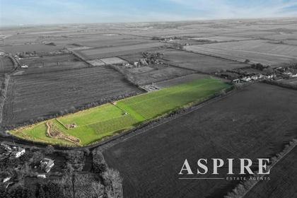
- Price
- Guide Price£650,000
- Size
- 9 acres
Added on 29/01/2026Vineyard
- Price
- £600,000
- Size
- 66 acres
Added on 29/01/2026Arable Land
- Price
- Guide Price£740,000
- Size
- 79.52 acres
Mickfield, Stowmarket, Suffolk, IP14, Mickfield, Suffolk IP14 5LS England
Added on 28/01/2026Farmland
- Price
- Guide Price£540,000
- Size
- 29.22 acres
Langdon Hills, Basildon, South Basildon and East Thurrock, Thurrock SS16 6JD England
Added on 30/05/2026Farmland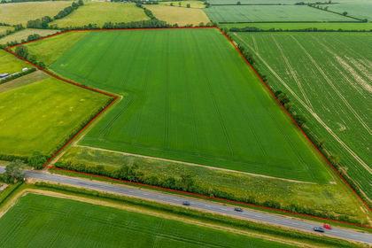
- Price
- Guide Price£525,000
- Size
- 38.28 acres
Land At Lower Road, Arrington, Royston, Cambridgeshire, Croydon, Cambridgeshire SG8 0HF England
Added on 09/06/2026Farmland