Maldon
- Land size
- 35 acres
Key Features
- Well Located Strategic Land
- Agricultural Permitted Development rights available
- Road Frontage
Description
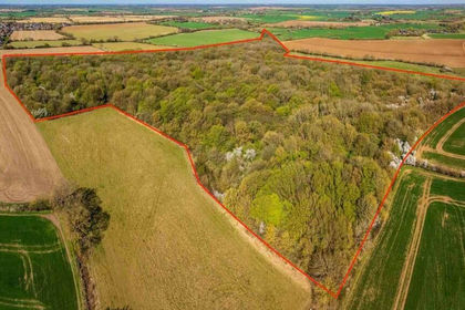
Approximately 35 acres Grade 3 arable land for sale with access from Lodge Road in Woodham Mortimer, Maldon.
Ideally located for a variety of uses including farming, small holding, vines, grazing, amenity and possible long term opportunities (subject to relevant consents).
BEST & FINAL OFFERS BY 12 NOON 4TH JUNE 2026 USING ATTACHED TENDER FORM.
Set within Woodham Mortimer, the land at Elms Farm lies approximately 1.7 miles south west of the town of Maldon and approximately 2.6 miles east of the village of Danbury, using straight line distances.
POSTCODE: CM9 6SJ
The land is currently farmed by a tenant with vacant possession due on 29th September 2026.
The local Planning Authority is Maldon District Council.
The land may benefit from Permitted Development rights, subject to the usual criteria and any necessary consents.
Prospective purchasers must make their own inquiries as to the likelihood of obtaining planning consent for any proposed use.
The land is sold subject to any easements, quasi easements, wayleaves, rights of way or obligations whether mentioned in these particulars or not.
A right of way is reserved by the vendor over the land shaded yellow on the plan, providing access to the field to the north.
Footpath EX|Woodham Mortimer|18 runds alongside the boundary to the north, outside of the ownership.
There are currently no services connected to the land. Prospective purchasers must make their own inquiries as to the suitability and availability of services.
The land will be sold subject to overage. The term of the overage will be 25 years. The Seller will reserve 25% of any uplift resulting from implementable planning for uses other than horticulture, equestrian, forestry, and agriculture (except where such uses permit independent residential habitation).
Whirledge & Nott does not have any authority to give representations or warranties in relation to the property. These particulars do not form part of any offer or contract. All descriptions, photographs and plans are for guidance only and should not be relied upon as statements or representations of fact. All measurements are approximate. No assumption should be made that the property has the necessary planning, building regulations or other consents. Whirledge & Nott has not carried out a survey nor tested any appliances, services or facilities. Purchasers must satisfy themselves by inspection or otherwise.
Strictly by appointment Viewing of the property is entirely at the risk of the enquirer. Neither Whirledge & Nott nor the vendor accept any responsibility for any damage, injury or accident during viewing.
Map Location
Property details
- Tenure
- Freehold
- Council Tax Band
- Ask Agent
- Date Posted
- 2026-05-02
Market Value Analysis
Compared with 51 Farmland & Pasture listings in East Anglia (25+ acres).
Utilities & Restrictions
Utilities
- Electricity
- Ask Agent
- Water
- Ask Agent
- Heating
- Ask Agent
- Broadband
- Ask Agent
- Sewerage
- Ask Agent
Rights & Restrictions
- Public Rights of Way
- Ask Agent
- Private Rights of Way
- Ask Agent
- Listed Property
- Ask Agent
- Restrictions
- Ask Agent
Property Features
- Accessibility
- Ask Agent
- Parking
- Ask Agent
- Garden
- Ask Agent
Important notice: Information, maps and tags on this page are supplied by the advertising agent or generated automatically. LandSale has not verified them. Relying on these details is at your own risk, always carry out independent checks before committing to a purchase.
LandSale full disclaimer
Marketing information only - not formal particulars. The details on this website are provided for general guidance and do not constitute an offer or contract. Neither LandSale nor the advertising estate/land agent accepts responsibility for any inaccuracy.
1. Source of information
- Agent-supplied content: Core description, asking price, tenure, measurements, photographs and planning history are uploaded by the appointed agent, who remains solely responsible for their accuracy.
- Automated tags & categorisation: Property type, land-use class, acreage bands and similar labels may be applied by machine-learning models. They are intended as a helpful guide only and may not reflect the property's legal status or permitted use.
- Third-party & enriched data layers: Maps, boundary outlines, planning designations, soil reports, broadband coverage and other environmental or location-based insights are licensed from external suppliers. Such data are supplied “as is", may be incomplete or out of date and are subject to change without notice.
2. Verification required
Prospective purchasers must verify critical matters, including but not limited to planning permission, title boundaries, public rights of way, environmental constraints, acreage, services, access and VAT status, through their own inspections, specialist surveys, legal advisers and the selling agent before relying on the information or entering into any contract.
3. No warranty or liability
LandSale gives no warranty, express or implied, as to the accuracy, completeness or fitness for any particular purpose of the information displayed. LandSale shall not be liable for any loss, damage, cost or expense arising directly or indirectly from any use of or reliance on such information, save where liability may not be excluded by law.
4. Updates & feedback
If you believe any detail on this listing is inaccurate, please let us know. We will investigate and, where appropriate, update the listing or notify the agent.
© LandSale | Version 1.2 - January 2026
Listing agent
Whirledge and Nott, Commercial
The Black Barn, Lubards Farm, Hullbridge Road, Rayleigh, SS6 9QG
Contact Whirledge and Nott, Commercial
The Black Barn, Lubards Farm, Hullbridge Road, Rayleigh, SS6 9QG
View agent profileSimilar properties for sale
- Price
- Guide Price£300,000
- Size
- 33.51 acres
Lord's Wood, Leaden Roding, Essex, Leaden Roding, Essex CM6 1WG England
Added on 11/06/2026Timberland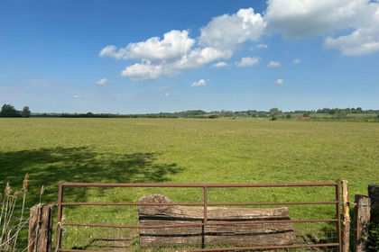
- Price
- Offers in Region of£250,000
- Size
- 30.47 acres
Land on the West Side of The Causeway, Lawford, Lawford, Essex CO11 1QJ England
Added on 05/07/2026Vacant Land
- Price
- Offers in Region of£225,000
- Size
- 0.75 acres
HorseShoe Rise, Round Street, Cobham, Kent, Cobham, Kent DA13 9AY England
Added on 29/01/2026Farmland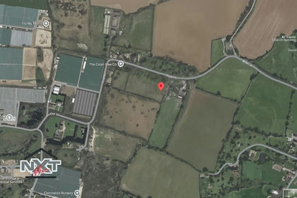
- Price
- Offers in Excess of£249,995
- Size
- 4.5 acres
Added on 29/01/2026Development Land Added on 29/01/2026Arable Land
- Price
- Offers Over£250,000
- Size
- 0.27 acres
Between Nettlestead & Somersham, Nr Ipswich, Suffolk, Nettlestead, Suffolk IP8 4QL England
Added on 29/01/2026Development Land
- Price
- Offers Over£250,000
- Size
- 0.27 acres
Between Nettlestead & Somersham, Nr Ipswich, Suffolk, Nettlestead, Suffolk IP8 4QJ England
Added on 29/01/2026Building Plot
- Price
- Guide Price£250,000
- Size
- 22 acres
Added on 29/01/2026Grazing Land
- Price
- Guide Price£475,000
- Size
- 37.74 acres
Lot 6 - The Oggstown Land, Chilham, Canterbury, Kent, Chilham, Kent CT4 8BA England
Added on 01/05/2026Farmland
- Price
- Guide Price£400,000
- Size
- 7.32 acres
Added on 01/05/2026Agricultural Land