Kneeton
- Land size
- 0.37 acres
Key Features
- Popular Nottinghamshire Village Location
- Exciting Renovation Project
- Development Potential, Subject to Planning
- Plot Size 0.37 Acre or Thereabouts
Description
An exciting residential development opportunity to acquire a a house which requires substantial renovation and bring it back to life or replace with a new dwelling, subject to planning permission. The property lies in the small village of Kneeton, a quaint, unspoilt Nottinghamshire village, with easy access on the A46 and A52 for access to Bingham, Nottingham, Newark and Grantham. The plot extends to 1497 sq. m (0.37 acre) or thereabouts, with frontage to Slacks Lane. Mains services including electricity, water and drainage are connected to the village of Kneeton, prospective purchases would need to make enquiries regarding serrvices available.
An exciting residential development opportunity to acquire a house which requires substantial renovation and bring it back to life or replace with a new dwelling, subject to planning permission. . The property lies in the small village of Kneeton, a quaint, unspoilt Nottinghamshire village, with easy access on the A46 and A52 for access to Bingham, Nottingham, Newark and Grantham. The plot extends to 1497 sq. m ( 0.37 acre) or thereabouts, with frontage to Slacks Lane. Mains services including electricity, water and drainage are connected to the village of Kneeton, prospective purchases would need to make enquiries regarding services available.
Kneeton Village - The village of Kneeton can be traced in history back to 1086 where it was recorded in the Domesday Book as "Chenuiton" and at the time of recording the village consisted of 5 tenant farmers, 3 freed men and one priest. Women and children were not recorded and it is estimated that the village consisted 8 or 9 households totaling 30 to 40 people. The village has has little growth in the last 900 years, with the last census recording a population of less than 100, with new houses in Kneeton being very rare and less than 10 being added in the 20th and 21st centuries.
In 2018 Kneeton became a conservation area with 10 of the local properties in the village being Grade II listed which in turn creates a unique and pretty setting.
The village of Kneeton is located 270ft above the River Trent, high up on the Trent hillside overlooking the Trent Valley and Vale of Belvoir countryside.
Location And Amenities - The subject property is in a prominent position on Slacks Lane in the centre of the village. The property is gable onto the lane and is pleasantly situated amoungst other period dwellings. The area is rural, with residential housing mixed with farms. Kneeton is a small village, located just off the A46. It lies 3 miles from Bingham town centre, 16 miles from Nottingham city centre, 29 miles from Leicester city centre and 31 miles from the city of Lincoln. The A46 & A52 are both conveniently placed for commuting.
Closer amenities, including shops, public houses and local schools can be found in the nearby village of East Bridgford which is only 1.8 miles away. The market town of Bingham is only a few minutes drive away and provides all the amenities necessary. There are fast trains running from Newark Northgate Station to London Kings Cross with a journey time of approximately 75 minutes.Rail servicers are located both at Bingham and Newark, with journey times to London 1 hour 30 minutes and 1 hour 20 minutes respectively.
There are two renowned primary schools located nearby. East Bridgford St Peter’s is 1.8 miles and Flintham Primary is 3.5 miles away. Both schools’ last Ofsted reports are recorded as Outstanding.
The Property - The property requires substantial renovation and comprises an early 19th Century, detached Nottinghamshire Farm House. It is two storey, with red brick elevations, beneath a mixed clay tiled and slate roof. There is an external porch over the front door, which has a slate pitch roof. The windows are currently boarded up and there are the original stone sills. The gross internal area of the farmhouse is over 2,500 sq.ft.
The property occupies a generous sized plot extending to approximately 0.37 acres (0.15 ha) and is enclosed by a stone wall to the front of the property and surrounded by established trees and shrubs around the border. To the rear of the property is open farmland.
The house is derelict and requires substantial renovation. The grounds are overgrown. A full renovation scheme will be required to bring this house elegantly back to life.
Front Of Property - (three storey - 2,559 sq.ft gross external area approximately)
Rear Wings - (two storey - 1,005 sq.ft gross external area approximately)
Single Storey Extension - Gross external area 134 sq.ft approximately
Overall Gross External Area - We estimate the overall gross external area to e 3,600 sq.ft approximately.
Planning - The property is sold as seen with no planning consents in place. The property is not listed and is located within the Kneeton Conservation Area. Any purchasers are advised to consult with Rushcliffe Council for any sympathetic extension plans.
Restrictive Covenant - There will be a restrictive covenant on the property for development of a single dwelling house only.
Services - We understand that mains water, electricity and drainage are available in Kneeton. Prospective purchases should make enquiries regarding services available to the property.
We are not aware the property has any current central heating system.
Tenure - The property is freehold and will be sold with vacant possession upon completion.
Mortgage - The property is not currently habitable and therefore unlikely to be mortgagable under domestic terms. Funding advice is available through our Mortgage Adviser. Your home is at risk if you do not keep up repayments on a mortgage or other loan secured on it.
Additional Information - Please see the links below to check for additional information regarding environmental criteria (i.e. flood assessment), school Ofsted ratings, planning applications and services such as broadband and phone signal. Note Richard Watkinson & Partners has no affiliation to any of the below agencies and cannot be responsible for any incorrect information provided by the individual sources.
Flood assessment of an area:-
Broadband & Mobile coverage:-
School Ofsted reports:-
Planning applications:-
Viewing & Agents Note - Viewing is strictly by appointment with the selling agents. The site must not be entered unattended, due to the derelict nature of the building.
Map Location
Property details
- Tenure
- Freehold
- Council Tax Band
- Ask Agent
- Date Posted
- 2026-04-24
Utilities & Restrictions
Utilities
- Electricity
- Ask Agent
- Water
- Ask Agent
- Heating
- Ask Agent
- Broadband
- Ask Agent
- Sewerage
- Ask Agent
Rights & Restrictions
- Public Rights of Way
- Ask Agent
- Private Rights of Way
- Ask Agent
- Listed Property
- Ask Agent
- Restrictions
- Yes
Listed status, conservation areas and planning constraints for this location are in the full report.
Property Features
- Accessibility
- Ask Agent
- Parking
- Ask Agent
- Garden
- Garden
Beyond the particulars: planning activity, flood history, heritage and ground risks, checked for this exact spot.
Connectivity
Broadband
Fastest speed available at this postcode
48 Mbps
Superfast
Suitable for
- HD streaming
- Video calls
- Web & social
Mobile signal
Predicted 4G and 5G signal; indoor signal depends on building materials.
Ofcom Connected Nations postcode-level predictions. Speeds and signal are modelled, not measured, and vary between addresses and providers.
Signal is the easy part. Planning activity, flood history and protected designations here are in the full report.
Nearest Schools
Primary
- Flintham Primary School1.2 milesOfsted: Good
- Ages
- 3 to 11
- Pupils
- 56
- Type
- Academy converter
- Bleasby Church of England Primary School2.2 milesNo Ofsted rating
- Ages
- 4 to 11
- Pupils
- 130
- Type
- Academy converter
- Faith
- Church of England
- All Saints Anglican/Methodist Primary School2.5 milesNo Ofsted rating
- Ages
- 3 to 11
- Pupils
- 93
- Type
- Voluntary aided school
- Faith
- Church of England/Methodist
- East Bridgford St Peters Church of England Academy2.7 milesOfsted: Good
- Ages
- 4 to 11
- Pupils
- 261
- Type
- Academy converter
- Faith
- Church of England
- Gunthorpe CofE Primary School2.8 milesOfsted report card · Feb 2026
- Ages
- 3 to 11
- Pupils
- 71
- Type
- Academy converter
- Faith
- Church of England
Secondary
- Toot Hill School4.4 milesOfsted: Good
- Ages
- 11 to 18
- Pupils
- 1,838
- Type
- Academy converter
- The Minster School4.4 milesOfsted: Good
- Ages
- 7 to 18
- Pupils
- 1,616
- Type
- Academy converter
- Faith
- Church of England
- South Nottinghamshire Academy6.3 milesNo Ofsted rating
- Ages
- 11 to 18
- Pupils
- 1,010
- Type
- Academy sponsor led
- Carlton le Willows Academy6.4 milesOfsted: Inadequate
- Ages
- 11 to 18
- Pupils
- 1,803
- Type
- Academy converter
- Magnus Church of England Academy6.6 milesOfsted: Requires improvement *
- Ages
- 11 to 18
- Pupils
- 678
- Type
- Academy sponsor led
- Faith
- Church of England
* Latest graded judgement covers quality of education only; no overall grade was issued under the 2024-25 inspection framework.
Distances are straight-line from the advertised location. Source: the national school registers (DfE, Welsh Government, Scottish Government) and Ofsted.
Schools are just the start: sold prices nearby, planning activity and any flood history are in the full report.
Amenities
Supermarket
GP surgery
Pharmacy
Hospital
Green space
Straight-line distances from the advertised location. Sources: NHS records, Geolytix supermarket locations, OS Open Greenspace and the national trails registers.
The area stacks up? Now check the location itself: planning nearby, protected designations and past flooding.
Getting Around
Nearest station
Nearest bus stop
Typical drive times
Straight-line distances from the advertised location; drive times are typical free-flow times over OpenStreetMap road data, so allow more at peak. Public transport locations from DfT NaPTAN.
Easy to reach matters. So do planning activity, flood history and ground risks: all in the full report.
Flood Risk
Environment Agency open data, checked around the advertised map pin for the listed acreage. Long-term risk counts flood defences; the planning map's flood zones do not. The map pin for this listing is approximate, so these readings describe the surrounding area. Provided by LandSale, not the listing agent, and not part of the agent's particulars. Risk varies across a holding, so verify before committing.
Rivers and the sea
Planning map: Flood Zone 1.
Surface water
Not at the pin: mapped about 10 metres away.
These bandings are the summary. Where this location sits on the flood maps, plus planning activity, heritage and ground risks, is in the full report.
Important notice: Information, maps and tags on this page are drawn from the advertising agent's marketing materials or generated automatically. LandSale has not verified them. Relying on these details is at your own risk, always carry out independent checks before committing to a purchase.
LandSale full disclaimer
Marketing information only - not formal particulars. The details on this website are provided for general guidance and do not constitute an offer or contract. Neither LandSale nor the advertising estate/land agent accepts responsibility for any inaccuracy.
1. Source of information
- Listing content: Core description, asking price, tenure, measurements, photographs and planning history originate from the marketing materials of the advertising estate or land agent. LandSale does not author this content and cannot guarantee its accuracy.
- Automated tags & categorisation: Property type, land-use class, acreage bands and similar labels may be applied by machine-learning models. They are intended as a helpful guide only and may not reflect the property's legal status or permitted use.
- Third-party & enriched data layers: Maps, boundary outlines, planning designations, soil reports, broadband coverage and other environmental or location-based insights are licensed from external suppliers. Such data are supplied “as is", may be incomplete or out of date and are subject to change without notice.
2. Verification required
Prospective purchasers must verify critical matters, including but not limited to planning permission, title boundaries, public rights of way, environmental constraints, acreage, services, access and VAT status, through their own inspections, specialist surveys, legal advisers and the selling agent before relying on the information or entering into any contract.
3. No warranty or liability
LandSale gives no warranty, express or implied, as to the accuracy, completeness or fitness for any particular purpose of the information displayed. LandSale shall not be liable for any loss, damage, cost or expense arising directly or indirectly from any use of or reliance on such information, save where liability may not be excluded by law.
4. Updates & feedback
If you believe any detail on this listing is inaccurate, please let us know. We will investigate and, where appropriate, update the listing or notify the agent.
© LandSale | Version 1.3 - August 2026
Listing agent
Richard Watkinson & Partners, Newark
25 Stodman Street Newark NG24 1AT
View agent profileSimilar properties for sale
- Price
- Offers Over£375,000
Priory Road, Thurgarton, Nottingham, Thurgarton, Nottinghamshire NG14 England
Added on 12/04/2026Barn Conversion
- Price
- Guide Price£275,000
- Size
- 0.19 acres
Old Epperstone Road, Lowdham, Nottingham, Lowdham, Nottinghamshire NG14 England
Added on 11/05/2026Building Plot Added on 05/08/2026Building Plot
- Price
- Guide Price£280,000
Church Lane, Bottesford, Nottingham, Nottinghamshire, NG13, Bottesford, Leicestershire NG13 England
Added on 29/01/2026Barn Conversion
- Price
- Guide Price£300,000
Marshall Street, Sherwood, Nottingham, Nottingham East, Nottingham NG5 England
Added on 29/01/2026Building Plot Added on 29/01/2026Building Plot
- Price
- £370,000
Pond Street, Great Gonerby, Grantham, Lincolnshire, NG31, Great Gonerby, Lincolnshire NG31 England
Added on 01/08/2026Barn Conversion
- Price
- Guide Price£375,000
The Hayloft, Barn 3, Park Farm, Newark Road, Wellow, Newark, Wellow, Nottinghamshire NG22 England
Added on 29/06/2026Barn Conversion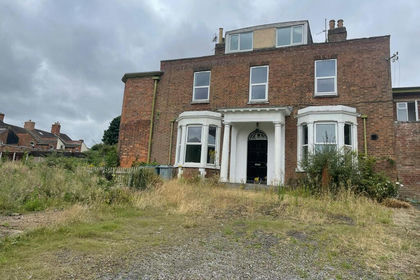
- Price
- Guide Price£305,000
- Size
- 0.7 acres
Barrowby Road, Grantham, Lincolnshire, Grantham, Lincolnshire NG31 England
Added on 18/07/2026Development Land
- Price
- £335,000
Added on 21/09/2026Pub