Castle Farm, Llangybi, NP15
Key Features
- Residential development opportunity
- Substantial traditional building (North Stable Range) comprising three existing residential units and stables, with full planning consent to reconfigure to provide four units
- Further significant traditional building (South Stable Range) and ancillary barns, currently unconverted, with full planning consent for four additional residential units
- Complementary amenity space comprising garden areas and allocated parking
- Highly desirable countryside location with far reaching views
Description
A unique opportunity to acquire an attractive development site featuring two substantial traditional buildings together with ancillary barns benefitting from full planning consent for conversion to create eight residential units.
DESCRIPTION
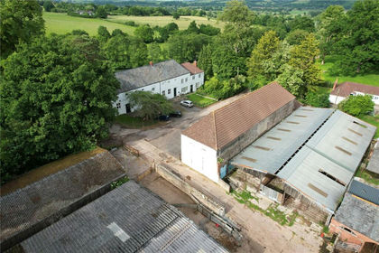
Castle Farm comprises a rural complex featuring two substantial traditional buildings, formerly used as stabling, with one being unconverted (the South Stable Range) and one incorporating three existing residential units (the North Stable Range). They, alongside the immediately surrounding farm buildings, benefit from full planning consent for conversion to create a residential complex of eight units in total together with associated amenity garden areas and allocated parking. The traditional buildings were constructed in the late 1700’s when Castle Farm operated as an agricultural holding, providing an impressive stable block and coach house with hay storage above. A range of traditional and historic features from the Victorian period remain visible throughout and have been carefully retained within the existing, converted units of the North Stable Range. The buildings were given Grade II listed status in early 2002 in recognition of their historic significance. This (truncated)
SITUATION
The property is situated on the outskirts of the popular village of Llangybi (0.8 miles), just south of the market town of Usk (2.7 miles), within the County of Monmouthshire. Owing to its location, the property enjoys a peaceful and private setting, screened by the surrounding pasture and woodland, albeit within close proximity to commuter routes. These include the A449 which connects to the A40, A48 and Junction 24 of the M4 Motorway Network, enabling convenient access to Newport (10.0 miles), Cardiff (23.7 miles) and Bristol (37.9 miles), all reachable within an hour’s drive. The village of Llangybi offers a small range of local amenities, including a pub and hall, with the nearby market town of Usk offering an extensive range of independent and national retailers together with an excellent choice of restaurants, pubs, leisure and other recreational services. Usk itself is widely regarded as one of Monmouthshire’s most desirable market towns, boasting historic charm. (truncated)
PLANNING CONSENT
There are two planning and listed building consents which have been obtained at the site, detailed below: North Stable Range – DM/2023/00032 & DM/2023/00038 The North Stable Range comprises a substantial traditional building formerly used for agricultural purposes and horse stabling, incorporating three existing residential units alongside an unconverted stable block. There is consent for reconfiguration and conversion to provide the following residential units: Stables House – A 3-bedroom end of terrace (existing), Arches Flat – A 2-bedroom ground floor flat (existing), Stables – A 3-bedroom mid-terrace (proposed), Fisherman’s Cottage – A large 3-bedroom end of terrace (existing). South Stable Range – DM/2023/00046 & DM/2023/00047 The South Stable Range comprises a further substantial traditional building which remains unconverted. Together with the immediately surrounding farm buildings, there is planning consent for conversion to provide the following residential (truncated)
TENURE
The property is sold freehold with vacant possession.
BOUNDARIES
The purchaser shall be deemed to have full knowledge of the boundaries and neither the Vendor nor the Agent should be required to produce evidence as to the ownership of the boundaries.
LOTTING & RESERVE
It is anticipated that the property will be offered as shown but the Vendor reserves the right to withdraw, alter or amend the extent of the property being offered.
EASEMENTS, COVENANTS & RIGHTS OF WAY
The property is sold subject to any rights, benefits or incidents of tenure which affect it. The driveway to the site is shared with additional users and whilst the freehold of such will be included with the development, those neighbouring properties will retain an unrestricted right of access. The vendor reserves the right to construct an access track across part of the site and will retain an unrestricted right of access over such.
SERVICES
There is a mains electricity connection available to the site, with the existing residential units within the North Stable Range also benefitting from mains water, private drainage to a shared septic tank, oil central heating to the Stables House and Fisherman’s Cottage, and solid fuel heating to Arches Flat. Under the planning consents referred to, there is provision for the installation of air source heat pumps and new private package treatment plants for each of the Stable Ranges. Purchasers are advised to make their own enquiries with the relevant providers with regards to any new connections.
COUNCIL TAX BANDS
The existing residential units within the North Stable Range fall within the following Council Tax bands: Stables House – Band E, Arches Flat – Band B, Fisherman’s Cottage – Band E.
EPC
The existing residential units within the North Stable Range hold the following valid EPC’s, expiring in 2032: Stables House – Band D, Arches Flat – Band C, Fisherman’s Cottage – Band D.
LOCAL AUTHORITY
Monmouthshire County Council –
DIRECTIONS
From the town centre of Usk, proceed west along Bridge Street, turning left onto Woodside Road towards the village of Llanbadoc. Continue south for approximately 2.2 miles, then turn right off the main road onto the shared private driveway, accessed through a gated entrance. The turning is located just before reaching the village of Llangybi. When using the mobile application – What Three Words:/// blanking.snail.research
VIEWING
Strictly by appointment with the Agents David James. Please telephone the Magor Office on . Alternatively, please email Ellie. or Rhiannon. .
GUIDE PRICE
Guide Price of £1,800,000 (One Million, Eight Hundred Thousand Pounds).
Map Location
Property details
- Tenure
- Freehold
- Council Tax Band
- TBC
- Date Posted
- 2026-04-16
Utilities & Restrictions
Utilities
- Electricity
- Ask Agent
- Water
- Ask Agent
- Heating
- Ask Agent
- Broadband
- Ask Agent
- Sewerage
- Ask Agent
Rights & Restrictions
- Public Rights of Way
- Ask Agent
- Private Rights of Way
- Ask Agent
- Listed Property
- Ask Agent
- Restrictions
- Ask Agent
Listed status, conservation areas and planning constraints for this location are in the full report.
Property Features
- Accessibility
- Ask Agent
- Parking
- Parking Available
- Garden
- Garden
Beyond the particulars: planning activity, flood history, heritage and ground risks, checked for this exact spot.
Connectivity
Broadband
Fastest speed available at this postcode
1.8 Gbps
Gigabit full fibre · available to 75% of premises
Suitable for
- 4K streaming on every screen
- Full-time home working
- Online gaming & big downloads
Mobile signal
Predicted 4G and 5G signal; indoor signal depends on building materials.
Ofcom Connected Nations postcode-level predictions. Speeds and signal are modelled, not measured, and vary between addresses and providers.
Signal is the easy part. Planning activity, flood history and protected designations here are in the full report.
Nearest Schools
Primary
- Usk Primary School2.4 miles
- Pupils
- 261
- Type
- Infants & Juniors
- Language
- English medium school / provision
- Ponthir Church In Wales School3.9 miles
- Pupils
- 101
- Type
- Infants & Juniors
- Language
- English medium school / provision
- Croesyceiliog Primary School4.1 miles
- Pupils
- 381
- Type
- Nursery, Infants & Juniors
- Language
- English medium school / provision
- New Inn Primary School4.1 miles
- Pupils
- 566
- Type
- Nursery, Infants & Juniors
- Language
- English medium school / provision
- Langstone Primary School4.2 miles
- Pupils
- 346
- Type
- Nursery, Infants & Juniors
- Language
- English medium school / provision
Secondary
- Croesyceiliog School4.1 miles
- Pupils
- 1,185
- Type
- Secondary (ages 11-16)
- Language
- English medium school / provision
- Caerleon Comprehensive School4.7 miles
- Pupils
- 1,471
- Type
- Secondary (ages 11-19)
- Language
- English medium school / provision
- West Monmouth School5.5 miles
- Pupils
- 1,149
- Type
- Secondary (ages 11-16)
- Language
- English medium school / provision
- St Julian's School5.6 miles
- Pupils
- 1,426
- Type
- Secondary (ages 11-19)
- Language
- English medium school / provision
- St. Albans R.C. High School5.7 miles
- Pupils
- 824
- Type
- Secondary (ages 11-16)
- Language
- English medium school / provision
Distances are straight-line from the advertised location. Source: the national school registers (DfE, Welsh Government, Scottish Government) and Ofsted.
Schools are just the start: sold prices nearby, planning activity and any flood history are in the full report.
Amenities
Supermarket
GP surgery
Pharmacy
Green space
Straight-line distances from the advertised location. Sources: NHS records, Geolytix supermarket locations, OS Open Greenspace and the national trails registers.
The area stacks up? Now check the location itself: planning nearby, protected designations and past flooding.
Getting Around
Nearest station
Nearest bus stop
Typical drive times
Straight-line distances from the advertised location; drive times are typical free-flow times over OpenStreetMap road data, so allow more at peak. Public transport locations from DfT NaPTAN.
Easy to reach matters. So do planning activity, flood history and ground risks: all in the full report.
Flood Risk
Natural Resources Wales open data, checked around the advertised map pin for the listed acreage. Long-term risk counts flood defences; the planning map's flood zones do not. Provided by LandSale, not the listing agent, and not part of the agent's particulars. Risk varies across a holding, so verify before committing.
Rivers and the sea
Planning map: Flood Zone 1.
Surface water
These bandings are the summary. Where this location sits on the flood maps, plus planning activity, heritage and ground risks, is in the full report.
Important notice: Information, maps and tags on this page are drawn from the advertising agent's marketing materials or generated automatically. LandSale has not verified them. Relying on these details is at your own risk, always carry out independent checks before committing to a purchase.
LandSale full disclaimer
Marketing information only - not formal particulars. The details on this website are provided for general guidance and do not constitute an offer or contract. Neither LandSale nor the advertising estate/land agent accepts responsibility for any inaccuracy.
1. Source of information
- Listing content: Core description, asking price, tenure, measurements, photographs and planning history originate from the marketing materials of the advertising estate or land agent. LandSale does not author this content and cannot guarantee its accuracy.
- Automated tags & categorisation: Property type, land-use class, acreage bands and similar labels may be applied by machine-learning models. They are intended as a helpful guide only and may not reflect the property's legal status or permitted use.
- Third-party & enriched data layers: Maps, boundary outlines, planning designations, soil reports, broadband coverage and other environmental or location-based insights are licensed from external suppliers. Such data are supplied “as is", may be incomplete or out of date and are subject to change without notice.
2. Verification required
Prospective purchasers must verify critical matters, including but not limited to planning permission, title boundaries, public rights of way, environmental constraints, acreage, services, access and VAT status, through their own inspections, specialist surveys, legal advisers and the selling agent before relying on the information or entering into any contract.
3. No warranty or liability
LandSale gives no warranty, express or implied, as to the accuracy, completeness or fitness for any particular purpose of the information displayed. LandSale shall not be liable for any loss, damage, cost or expense arising directly or indirectly from any use of or reliance on such information, save where liability may not be excluded by law.
4. Updates & feedback
If you believe any detail on this listing is inaccurate, please let us know. We will investigate and, where appropriate, update the listing or notify the agent.
© LandSale | Version 1.3 - August 2026
Listing agent
David James, Magor
Court Barn, West End, Magor, Monmouthshire, NP26 3HT
Call agent
01633 880220Contact David James, Magor
Court Barn, West End, Magor, Monmouthshire, NP26 3HT
Call agent
01633 880220Similar properties for sale
- Price
- Guide Price£1,800,000
Castle Farm, Llangybi, NP15, Llangybi, Monmouthshire NP15 Wales
Added on 03/04/2026Development Land
- Price
- £1,800,000
Added on 29/01/2026Development Land
- Price
- £1,500,000
- Size
- 228 acres
Llanfoist, Abergavenny., Llanfoist Fawr, Monmouthshire NP7 Wales
Added on 11/05/2026Farmland
- Price
- Guide Price£1,950,000
- Size
- 1.4 acres
Wraxall Hill, Wraxall, Bristol, Somerset, BS48, Wraxall and Failand, North Somerset BS48 England
Added on 18/04/2026Historic House
- Price
- Guide Price£1,800,000
Hereford, Herefordshire, Llanwarne, Herefordshire, County of HR2 England
Added on 13/08/2026Development Land
- Price
- Guide Price£1,800,000
Added on 24/08/2026Development Land
- Price
- £1,950,000
Added on 25/05/2026Development Land
- Price
- £1,400,000
- Size
- 3 acres
Summer Lane, Banwell, North Somerset, BS29, Banwell, North Somerset BS29 England
Added on 29/01/2026Development Land
- Price
- Guide Price£1,750,000
- Size
- 6.21 acres
Land at Beavers Lodge Farm, Lympsham Road, BS24, Lympsham, Somerset BS24 England
Added on 29/01/2026Development Land
- Price
- Guide Price£1,750,000
- Size
- 6.36 acres
Cannington, Bridgwater, Somerset, Cannington, Somerset TA5 England
Added on 05/03/2026Undeveloped Land