West Park Road, Newport-on-Tay, Fife
Description
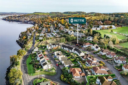
2 or 4 House Development, West Park Road, Newport on Tay, DD6 8NP with Spectacular Tay Coast Views. Elevated building plot spanning 1,248 square metres which can be split depending on the purchasers’ requirements:
- Plot 1 – 612 sqm offers over £140k
- Plot 2 – 636 sqm offers over £155k
Full planning permission in place and grounds works already commenced for four contemporary and architecturally designed townhouses. Previous planning permission for two 5 bedroom detached homes which can be reverted.
Fife Council planning Ref No. 21/03892/FULL
Elevated plot with captivating River Tay views
Sought-after location within easy reach of Dundee and St Andrews
Quiet and established residential street
Excellent array of amenities including schooling
EPC Rating - N/A
Council Band - N/A
Tenure - Freehold
Property Details & Description
General Description
Designed with modern luxury in mind, each of the homes will offer an exceptional living experience, blending contemporary style with relaxed comfort.
At the heart of each home will be the expansive open-plan living, dining, and kitchen area, designed to enhance the flow of space and light and perfect for both everyday living and entertaining.
Outside, each home will boast terraced landscaped gardens with breathtaking views of the River Tay. Private covered off-street parking ensures convenience and security for residents.
In addition to this, the homes will be built with sustainability and economic efficiency in mind, equipped with air-source heat pumps and solar panels.
Situation
The plots are located on a quiet, well-established residential street, offering a sought-after elevated position in Newport-on-Tay. A small and welcoming town on the banks of the River Tay, it boasts a bustling high street with independent retailers to meet daily shopping needs. For recreational pursuits, it is perfect for keen sailing enthusiasts and golfers will love the facilities at Scotscraig Golf Club. Waterstone Crook Sports Centre offers a gym and fitness classes.
For an even greater choice of cultural and visitor attractions, vibrant Dundee, home to the V&A and the revitalised waterfront with the famous RRS Discovery is only nine miles away whilst St Andrews, the ‘home of golf’ is just 13 miles by car and boasts an array of boutiques, bars, and restaurants. Edinburgh is approximately 60 minutes to the south. The characterful fishing villages and beautiful beaches of Anstruther, St Monans, Crail, Elie, and Pittenweem are all easily accessible as are the Lomond Hills.
The area boasts various visitor attractions including the ruins of Balmerino Abbey and the Fife Coastal Path which passes through Newport-on Tay. Alongside primary schooling in Newport-on-Tay and high school choices in Cupar and St Andrews, private options are available at St Leonards in St Andrews and The High School of Dundee. There is a train station in Dundee, with Edinburgh International Airport an hour away by car. Domestic flights are available from Dundee.
General Remarks & Information
Satellite Navigation
For the benefit of those with satellite navigation the property’s postcode is DD6 8NP
Fixtures & Fittings
Only items specifically mentioned in the particulars of sale are included in the sale price.
Entry & Possession
Entry and vacant possession will be by mutual agreement and arrangement.
Services
Mains water, electricity, gas, and drainage.
Council Tax
Band N/A
EPC Rating
Band N/A
Local Authority
Fife Council, Fife House, North Street, Glenrothes, Fife KY7 5LT Tel:
Offers
Offers should be submitted in Scottish Legal Form to the selling agents Rettie & Co at 28 Bell Street, St Andrews KY16 9UX.
Servitude Rights, Burdens & Wayleaves
The property is sold subject to and with the benefit of all servitude rights, burdens, reservations and wayleaves including rights of access and rights of way, whether public or private, light, support, drainage, water and wayleaves for masts, pylons, stays, cable, drains and water, gas and other pipes whether contained in the title deeds or informally constituted and whether or not referred to above.
Particulars and Plans
These particulars and plan are believed to be correct, but they are in no way guaranteed. Any error, omission or misstatement shall not annul the sale or entitle any party to compensation nor in any circumstances give grounds for action at law.
The photographs in this brochure date from September 2024 CGI's for illustrative purposes
Websites and Social Media
Proof and Source of Funds/Anti Money Laundering
Under the HMRC Anti Money Laundering legislation all offers to purchase a property on a cash basis or subject to mortgage require evidence of source of funds. This may include evidence of bank statements/funding source, mortgage or confirmation from a solicitor the purchaser has the funds to conclude the transaction. All individuals involved in the transaction are required to produce proof of identity and proof of address. This is acceptable either as original or certified documents.
Misrepresentations
1. The property is sold with all faults and defects, whether of condition or otherwise and neither the seller nor Rettie & Co, the selling agent, are responsible for such faults and defects, nor for any statement contained in the particulars of the property prepared by the said agent.
2. The Purchaser(s) shall be deemed to acknowledge that he has not entered into contact in reliance on the said statements, that he has satisfied himself as to the content of each of the said statements by inspection or otherwise and that no warranty or representation has been made by the seller or the said agents in relation to or in connection with the property.
3. Any error, omission or misstatement in any of the said statements shall not entitle the purchaser(s) to rescind or to be discharged from this contract, nor entitle either party to compensation or damages nor in any circumstances to give either party any cause for action.
Council Tax Band: NA
Map Location
Property details
- Tenure
- Freehold
- Council Tax Band
- TBC
- Date Posted
- 2026-03-31
Price history
| Date | Change | Price |
|---|---|---|
| 16 Sep 2026 | Reduced 16.2% (−£30,000) | £155,000 |
| Until 16 Sep 2026 | Asking price | £185,000 |
Utilities & Restrictions
Utilities
- Electricity
- Ask Agent
- Water
- Ask Agent
- Heating
- Ask Agent
- Broadband
- Ask Agent
- Sewerage
- Ask Agent
Rights & Restrictions
- Public Rights of Way
- Ask Agent
- Private Rights of Way
- Ask Agent
- Listed Property
- Ask Agent
- Restrictions
- Ask Agent
Listed status, conservation areas and planning constraints for this location are in the full report.
Property Features
- Accessibility
- Ask Agent
- Parking
- Parking Available
- Garden
- Garden
Beyond the particulars: planning activity, flood history, heritage and ground risks, checked for this exact spot.
Connectivity
Broadband
Fastest speed available at this postcode
80 Mbps
Superfast
Suitable for
- HD streaming
- Video calls
- Web & social
Mobile signal
Predicted 4G and 5G signal; indoor signal depends on building materials.
Ofcom Connected Nations postcode-level predictions. Speeds and signal are modelled, not measured, and vary between addresses and providers.
Signal is the easy part. Planning activity, flood history and protected designations here are in the full report.
Nearest Schools
Primary
- Wormit Primary School725 metres
- Pupils
- 192
- Type
- Non-denominational
- Newport Primary School0.8 miles
- Pupils
- 199
- Type
- Non-denominational
- Blackness Primary School2.2 miles
- Pupils
- 329
- Type
- Non-denominational
- Glebelands Primary School2.5 miles
- Pupils
- 356
- Type
- Non-denominational
- Victoria Park Primary School2.6 miles
- Pupils
- 202
- Type
- Non-denominational
Secondary
- Harris Academy2.7 miles
- Pupils
- 1,338
- Type
- Non-denominational
- Morgan Academy3 miles
- Pupils
- 942
- Type
- Non-denominational
- Craigie High School3.1 miles
- Pupils
- 725
- Type
- Non-denominational
- St John's RC High School3.4 miles
- Pupils
- 1,279
- Type
- Roman Catholic
- St Paul's RC Academy3.9 miles
- Pupils
- 997
- Type
- Roman Catholic
Distances are straight-line from the advertised location. Source: the national school registers (DfE, Welsh Government, Scottish Government) and Ofsted.
Schools are just the start: planning activity, heritage and any flood history here are in the full report.
Amenities
Supermarket
GP surgery
Pharmacy
Green space
Walking trail
Straight-line distances from the advertised location. Sources: NHS records, Geolytix supermarket locations, OS Open Greenspace and the national trails registers.
The area stacks up? Now check the location itself: planning nearby, protected designations and past flooding.
Getting Around
Nearest station
Nearest bus stop
Typical drive times
Straight-line distances from the advertised location; drive times are typical free-flow times over OpenStreetMap road data, so allow more at peak. Public transport locations from DfT NaPTAN.
Easy to reach matters. So do planning activity, flood history and ground risks: all in the full report.
Flood Risk
SEPA open data, checked around the advertised map pin for the listed acreage. The map pin for this listing is approximate, so these readings describe the surrounding area. Provided by LandSale, not the listing agent, and not part of the agent's particulars. Risk varies across a holding, so verify before committing.
Rivers and the sea
Surface water
These bandings are the summary. Where this location sits on the flood maps, plus planning activity, heritage and ground risks, is in the full report.
Important notice: Information, maps and tags on this page are drawn from the advertising agent's marketing materials or generated automatically. LandSale has not verified them. Relying on these details is at your own risk, always carry out independent checks before committing to a purchase.
LandSale full disclaimer
Marketing information only - not formal particulars. The details on this website are provided for general guidance and do not constitute an offer or contract. Neither LandSale nor the advertising estate/land agent accepts responsibility for any inaccuracy.
1. Source of information
- Listing content: Core description, asking price, tenure, measurements, photographs and planning history originate from the marketing materials of the advertising estate or land agent. LandSale does not author this content and cannot guarantee its accuracy.
- Automated tags & categorisation: Property type, land-use class, acreage bands and similar labels may be applied by machine-learning models. They are intended as a helpful guide only and may not reflect the property's legal status or permitted use.
- Third-party & enriched data layers: Maps, boundary outlines, planning designations, soil reports, broadband coverage and other environmental or location-based insights are licensed from external suppliers. Such data are supplied “as is", may be incomplete or out of date and are subject to change without notice.
2. Verification required
Prospective purchasers must verify critical matters, including but not limited to planning permission, title boundaries, public rights of way, environmental constraints, acreage, services, access and VAT status, through their own inspections, specialist surveys, legal advisers and the selling agent before relying on the information or entering into any contract.
3. No warranty or liability
LandSale gives no warranty, express or implied, as to the accuracy, completeness or fitness for any particular purpose of the information displayed. LandSale shall not be liable for any loss, damage, cost or expense arising directly or indirectly from any use of or reliance on such information, save where liability may not be excluded by law.
4. Updates & feedback
If you believe any detail on this listing is inaccurate, please let us know. We will investigate and, where appropriate, update the listing or notify the agent.
© LandSale | Version 1.3 - August 2026
Listing agent
Rettie, St.Andrews
28 Bell Street, St. Andrews, KY16 9UX
Similar properties for sale
- Price
- Offers Over£140,000
West Park Road, Newport-on-Tay, Fife, North East Fife, Fife DD6 Scotland
Added on 31/03/2026Building Plot
- Price
- Guide Price£150,000
Added on 15/10/2026Building Plot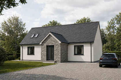
- Price
- Fixed Price£165,000
- Size
- 0.23 acres
Strathern Road, Dundee, DD5, Dundee Central, Dundee City DD4 Scotland
Added on 18/08/2026Building Plot
- Price
- Offers Over£150,000
- Size
- 0.21 acres
Burnside, Balmullo, St. Andrews, North East Fife, Fife KY16 Scotland
Added on 29/01/2026Building Plot
- Price
- Offers Over£120,000
Added on 18/04/2026Building Plot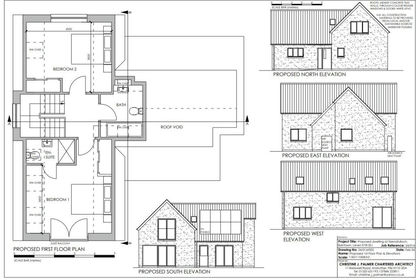
- Price
- Offers Over£129,000
Added on 29/07/2026Building Plot
- Price
- Guide Price£120,000
- Size
- 0.36 acres
Added on 04/06/2026Building Plot
- Price
- Offers Over£140,000
Bank Street, Kirriemuir, DD8, Angus and Perthshire Glens, Angus DD8 Scotland
Added on 29/01/2026Development Land
- Price
- Offers Over£120,000
- Size
- 0.17 acres
Added on 08/10/2026Building Plot
- Price
- Offers Over£150,000
High Street, Pittenweem, Anstruther, Fife, North East Fife, Fife KY10 Scotland
Added on 28/01/2026Redevelopment Land