Batcombe, Dorchester
- Land size
- 10.34 acres
- Bedrooms
- 6
- Bathrooms
- 4
Key Features
- Surprisingly back on the market through no fault of the property
- A well equipped equestrian property located in a beautiful peaceful setting
- Tranquil West Dorset countryside with far reaching views
- A substantial four bedroom principal house
- Detached modern two bedroom barn conversion
- The owner has advised us the property has not flooded
- Excellent range of outbuildings suitable for a variety of uses
- Nine stables, tack room, straw barn and manége
- Productive pasture land with river frontage
- 10.34 acres (4.18 hectares)
Description
Surprisingly back on the market through no fault of the property. A well equipped equestrian property located in a beautiful peaceful setting. Comprising a substantial four bedroom principal house, detached modern two bedroom barn conversion, nine stables, tack room, straw barn, manége and 10.34 acres (4.18 hectares).
Situation - Brookfield Farm is situated in glorious open West Dorset countryside between the towns of Dorchester and Yeovil. It is situated off Wriggle River Lane, a quiet country lane, between the villages of Batcombe and Leigh. The property benefits from a rural location yet is close to local amenities. Yeovil offers a range of facilities including retail, recreation, and schooling, and two mainline railway stations (London Waterloo 2.5 hours and London Paddington 3 hours). The A37 is 10 minutes away and provides excellent road links. The area is renowned for its schooling with Perrott Hill, Hazlegrove, and Sherborne schools all within just over 30 minutes. There is a good network of quiet country lanes and bridleways on the doorstep for riding, walking, and cycling. There are no public rights of way affecting the property. Set to the north of the holding and accessed from Seiver’s Lane is Seiver’s Copse, where the Wriggle River and Batcombe Stream cross. The copse boasts bluebell and wood anemone and an array of wildlife whilst Seiver’s Lane forms a medieval drove and bridleway.
Introduction - Far from the Madding Crowd, Brookfield Farm with its 360-degree views must have one of the best and most tranquil locations in Thomas Hardy’s Dorset: yet it is within easy reach of Sherborne, Yeovil and Dorchester. Having been run for over 50 years as a successful Arab horse breeding stud, this is the first time that the property with its architect-designed four-bedroomed house has been offered for sale. Under the current ownership, the main house has undergone extension and upgrading to a high specification. The property has a superb barn conversion with handcraftedoak beams and trusses, oak cottage doors and granite flooring which retains the heat from the under-floor heating. The barn forms a courtyard with the stable yard of nine loose boxes, all of which have rubber mats, and a tack room. There is also a recent steel-framed haybarn. Together the property totals 10.34 acres of level pasture which lies between the medieval Seiver’s Lane with its ancient oaks and bluebell and anemone woods, and the River Wriggle renowned for its “Wriggle Stones”, starshaped fossils, and abundant wildlife.
The House - Sitting towards the northern boundary, the house faces west and is surrounded by lawns and a paved patio. The property is constructed of brick elevations under a tile roof. The windows and doors are UPVC double glazed. The main house offers good equal sized rooms and provides a total of 1,998 sq ft of accommodation. Both the sitting room and dining room enjoy doors leading out onto the patio and rear garden. The sitting room features a traditional wood burning hearth with marble surround. The kitchen has a quarry tiled floor, with fully fitted Sheraton Craftsman Oak units, integrated oven and ceramic hob, and an oil fired Rayburn. On the first floor, the large landing gives access to four good sized bedrooms, one of which has a balcony with stunning views over the adjoining pasture land. The ground floor study could serve as a fifth bedroom. Attached to the northern elevation of the house is a double garage of the same construction as the house.
Please see floorplan for accommodation and measurements.
The Barn Conversion - Set to the south of the main house is an impressive self-contained two-bedroom barn conversion boasting open plan modern living featuring hand-crafted oak trusses and beams, oak cottage doors, two bathrooms, and far-reaching views. The barn conversion comprises rendered elevations under a slate tile roof and benefits from granite tiled flooring over sub-floor heating throughout.
Please see floorplan for accommodation and measurements.
Grounds - The main house is surrounded by well-manicured lawns with a patio set to the west. The garden features a number of well-established trees and shrubs and an array of fruit trees adjoining the eastern boundary. There are two vegetable patches on the northern boundary. The property is well screened by well-established trees along the lane side boundary. The barn conversion benefits from an enclosed garden with lawns to the west with well-established flowerbeds and a patio area.
The Approach - The property is accessed directly from Wriggle River Lane. The main house has its own separate gated access through a tarmacked driveway. The barn conversion and yard have their own gated access directly from Wriggle River Lane through the concrete yard.
The Stable And Barns - Three sets of purpose-built stables provide for a total of nine stables and a tack room. The steel framed straw barn provides general storage (see floorplan). The outbuildings cover in total over 2,500 sq ft (240 sq m). All buildings were erected to a high specification for their purpose. The stabling is within close access of the main house and the barn conversion for easy monitoring. There is also a former manége set to the west of the buildings.
The Land - The land is predominantly level with some gentle slopes and extends to a total of 10.34 acres (4.18 hectares). It surrounds the main holding and boasts stunning views of the adjoining countryside. The soil is slightly acid but base rich loamy and clayey soil. Divided into three parcels by stockproof fencing and mature hedgerows. There are also a number of mature trees providing good shade. Currently in a permanent pasture mix and managed for horses, the land is equally suited to livestock uses. On the western boundary is the River Wriggle renowned for its “Wriggle Stones”, star-shaped fossils, and providing a haven for wildlife. There is a bridge along the eastern boundary providing access to the river.
Services - Mains water and mains electricity to the house, barn conversion and buildings. Oil-fired central heating to both properties. Private drainage.
Full fibre broadband available.
Epc Rating - House E
Barn conversion D
Flooding - The property being near the source of the Wriggle has never been known to flood,
Directions - The entrance to the property is off Wriggle River Lane, north of Batcombe, signed from the A37.
WhatThreeWords: ///defended.showering.translate
Map Location
Property details
- Tenure
- Freehold
- Council Tax Band
- E
- Date Posted
- 2026-03-26
Market Value Analysis
Compared with 22 Equestrian listings in South West England (10+ acres).
Energy Performance Certificate
Energy Efficiency Rating
Based on UK Energy Performance Certificate standards (EU Directive 2002/91/EC)
Running costs are one side. Planning activity, flood history and ground risks for this location are in the full report.
Utilities & Restrictions
Utilities
- Electricity
- Mains
- Water
- Mains
- Heating
- Oil Heating
- Broadband
- Ask Agent
- Sewerage
- Septic Tank / Private
Rights & Restrictions
- Public Rights of Way
- Ask Agent
- Private Rights of Way
- Ask Agent
- Listed Property
- Ask Agent
- Restrictions
- Ask Agent
Listed status, conservation areas and planning constraints for this location are in the full report.
Property Features
- Accessibility
- Ask Agent
- Parking
- Garage
- Garden
- Garden
Beyond the particulars: planning activity, flood history, heritage and ground risks, checked for this exact spot.
Connectivity
Broadband
Fastest speed available at this postcode
80 Mbps
Superfast · available to 71% of premises
Suitable for
- HD streaming
- Video calls
- Web & social
Mobile signal
Predicted 4G and 5G signal; indoor signal depends on building materials.
Ofcom Connected Nations postcode-level predictions. Speeds and signal are modelled, not measured, and vary between addresses and providers.
Signal is the easy part. Planning activity, flood history and protected designations here are in the full report.
Nearest Schools
Primary
- Sticklands Church of England Voluntary Aided Primary School2.7 milesOfsted: Good *
- Ages
- 5 to 11
- Pupils
- 70
- Type
- Voluntary aided school
- Faith
- Church of England
- Cerne Abbas CofE VC First School3.3 milesOfsted: Good
- Ages
- 3 to 9
- Pupils
- 77
- Type
- Voluntary controlled school
- Faith
- Church of England
- Maiden Newton, Greenford Church of England Primary School4.1 milesOfsted: Good
- Ages
- 4 to 11
- Pupils
- 137
- Type
- Voluntary controlled school
- Faith
- Church of England
- St Andrew's Church of England Primary School4.6 milesOfsted report card · Mar 2026
- Ages
- 4 to 11
- Pupils
- 99
- Type
- Academy converter
- Faith
- Church of England
- Buckland Newton Church of England Primary School4.7 milesOfsted report card · Feb 2026
- Ages
- 2 to 11
- Pupils
- 110
- Type
- Academy converter
- Faith
- Church of England
Secondary
- The Gryphon School8.7 milesNo Ofsted rating
- Ages
- 11 to 18
- Pupils
- 1,569
- Type
- Academy converter
- Faith
- Church of England
- Beaminster School8.8 milesOfsted: Good
- Ages
- 11 to 18
- Pupils
- 673
- Type
- Voluntary controlled school
- Faith
- Christian
- Preston School Academy9.1 milesOfsted: Good
- Ages
- 11 to 16
- Pupils
- 1,003
- Type
- Academy converter
- Buckler's Mead School9.1 milesOfsted: Good
- Ages
- 11 to 16
- Pupils
- 812
- Type
- Academy converter
- Westfield Academy9.1 milesNo Ofsted rating
- Ages
- 11 to 16
- Pupils
- 1,013
- Type
- Academy converter
* Latest graded judgement covers quality of education only; no overall grade was issued under the 2024-25 inspection framework.
Distances are straight-line from the advertised location. Source: the national school registers (DfE, Welsh Government, Scottish Government) and Ofsted.
Schools are just the start: sold prices nearby, planning activity and any flood history are in the full report.
Amenities
Supermarket
GP surgery
Pharmacy
Hospital
Straight-line distances from the advertised location. Sources: NHS records, Geolytix supermarket locations, OS Open Greenspace and the national trails registers.
The area stacks up? Now check the location itself: planning nearby, protected designations and past flooding.
Getting Around
Nearest station
Nearest bus stop
Typical drive times
Straight-line distances from the advertised location; drive times are typical free-flow times over OpenStreetMap road data, so allow more at peak. Public transport locations from DfT NaPTAN.
Easy to reach matters. So do planning activity, flood history and ground risks: all in the full report.
Flood Risk
Environment Agency open data, checked around the advertised map pin for the listed acreage. Long-term risk counts flood defences; the planning map's flood zones do not. Provided by LandSale, not the listing agent, and not part of the agent's particulars. Risk varies across a holding, so verify before committing.
Rivers and the sea
Planning map: Flood Zone 1.
Surface water
These bandings are the summary. Where this location sits on the flood maps, plus planning activity, heritage and ground risks, is in the full report.
Important notice: Information, maps and tags on this page are drawn from the advertising agent's marketing materials or generated automatically. LandSale has not verified them. Relying on these details is at your own risk, always carry out independent checks before committing to a purchase.
LandSale full disclaimer
Marketing information only - not formal particulars. The details on this website are provided for general guidance and do not constitute an offer or contract. Neither LandSale nor the advertising estate/land agent accepts responsibility for any inaccuracy.
1. Source of information
- Listing content: Core description, asking price, tenure, measurements, photographs and planning history originate from the marketing materials of the advertising estate or land agent. LandSale does not author this content and cannot guarantee its accuracy.
- Automated tags & categorisation: Property type, land-use class, acreage bands and similar labels may be applied by machine-learning models. They are intended as a helpful guide only and may not reflect the property's legal status or permitted use.
- Third-party & enriched data layers: Maps, boundary outlines, planning designations, soil reports, broadband coverage and other environmental or location-based insights are licensed from external suppliers. Such data are supplied “as is", may be incomplete or out of date and are subject to change without notice.
2. Verification required
Prospective purchasers must verify critical matters, including but not limited to planning permission, title boundaries, public rights of way, environmental constraints, acreage, services, access and VAT status, through their own inspections, specialist surveys, legal advisers and the selling agent before relying on the information or entering into any contract.
3. No warranty or liability
LandSale gives no warranty, express or implied, as to the accuracy, completeness or fitness for any particular purpose of the information displayed. LandSale shall not be liable for any loss, damage, cost or expense arising directly or indirectly from any use of or reliance on such information, save where liability may not be excluded by law.
4. Updates & feedback
If you believe any detail on this listing is inaccurate, please let us know. We will investigate and, where appropriate, update the listing or notify the agent.
© LandSale | Version 1.3 - August 2026
Similar properties for sale
- Price
- Guide Price£1,110,000
- Size
- 16.91 acres
Melbury Bubb, Dorchester, DT2, Dorchester, Dorset DT2 England
Added on 16/06/2026Smallholding
- Price
- Guide Price£1,500,000
- Size
- 15 acres
Added on 18/04/2026Farmhouse
- Price
- Guide Price£1,225,000
- Size
- 9.2 acres
Added on 29/01/2026Farmhouse
- Price
- Guide Price£1,225,000
- Size
- 9 acres
Added on 29/01/2026House with Land
- Price
- Guide Price£1,275,000
- Size
- 7.71 acres
Added on 28/09/2026House with Land
- Price
- Guide Price£1,100,000
- Size
- 5 acres
Hill End, Hardington Mandeville, Somerset, BA22, Hardington Mandeville, Somerset BA22 England
Added on 01/05/2026House with Land
- Price
- Guide Price£999,999
- Size
- 9.15 acres
South Perrott, Beaminster, South Perrott, Dorset DT8 England
Added on 04/07/2026Cottage
- Price
- Guide Price£1,350,000
- Size
- 34 acres
Milton Abbas, Blandford Forum, Dorset, Milton Abbas, Dorset DT11 England
Added on 19/03/2026House with Land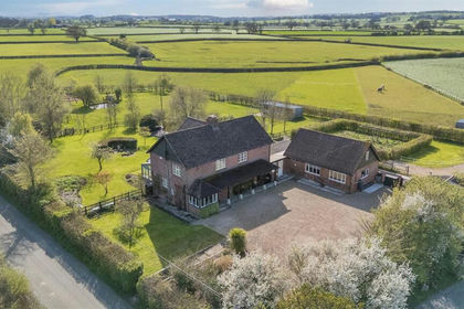
- Price
- Guide Price£1,050,000
- Size
- 5 acres
Lower Bagber, Sturminster Newton, Sturminster Newton, Dorset DT10 England
Added on 16/04/2026House with Land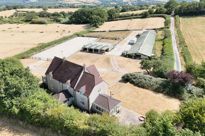
- Price
- Guide Price£1,575,000
- Size
- 9.99 acres
New Road, Broad Oak, Sturminster Newton, Sturminster Newton, Dorset DT10 England
Added on 02/09/2026House with Land