NETTLETON, Normanby Road, LN7
- Land size
- 13.04 acres
Key Features
- The land is situated to the west of Normanby Road, within the village of Nettleton.
- Planning permission was granted in 1995 for the erection of a block of 4 stables on the land, under the planning reference: W66/681/95.
- The land is in an Area of Outstanding Natural Beauty (AONB).
- The land may be viewed at any reasonable time during daylight hours being in possession of a set of these particulars.
- The land is offered for sale as a whole by Private Treaty.
Description
The land is situated to the west of Normanby Road, within the village of Nettleton, in the West Lindsey District of Lincolnshire. The market town of Caistor lies less than two miles to the north, the market town of Market Rasen lies approximately eight miles to the south and the market town of Brigg sits approximately eleven miles to the north-west.
Description
The land comprises an irregular-shaped parcel of permanent grassland, extending to approximately 13.04 acres, which could easily be split into two paddocks Access is directly from Normanby Road via a double gateway. The land is in an Area of Outstanding Natural Beauty (AONB). The land is currently used for growing hay, but it would also be suitable for horse grazing (subject to obtaining planning). The land is registered on HM Land Registry under Title Number LL108009.
Planning permission was granted in 1995 for the erection
of a block of 4 stables on the land, under the planning
reference: W66/681/95.
Tenure & Possession
The land for sale freehold and with the benefit of vacant possession.
There is a water supply to the land.
Development Clause
The land is offered for sale subject to a development clause, whereby 50% of any uplift in value (resulting from an alternative use) in excess of the existing value, is reserved to the current owner for a period of 50 years, commencing from the date of completion.
Nitrate Vulnerable Zone (NVZ)
The land lies within a designated Nitrate Vulnerable Zone. For further details, visit:-
Easements, Wayleaves & Rights of Way
There is a wayleave in favour of Northern Powergrid in respect of overhead lines and poles crossing the land. The land is sold subject to all other rights of way, reservation of minerals, water, drainage, other easements and wayleaves and all rights of access, whether mentioned in these particulars or not.
Value Added Tax (VAT)
The sale price is agreed on a VAT exclusive basis and the Purchaser(s) shall indemnify the Vendor for any VAT, which may be subsequently payable.
Viewing
The land may be viewed at any reasonable time during daylight hours being in possession of a set of these particulars.
Method of sale
The land is offered for sale as a whole. Interested parties are invited to speak to Cecilie Lister of the Selling Agents on or to discuss their interest.
Map Location
Property details
- Tenure
- Freehold
- Council Tax Band
- Ask Agent
- Date Posted
- 2026-03-20
Market Value Analysis
Compared with 94 Farmland & Pasture listings in East Midlands (10+ acres).
Utilities & Restrictions
Utilities
- Electricity
- Ask Agent
- Water
- Ask Agent
- Heating
- Ask Agent
- Broadband
- Ask Agent
- Sewerage
- Ask Agent
Rights & Restrictions
- Public Rights of Way
- Ask Agent
- Private Rights of Way
- Ask Agent
- Listed Property
- Ask Agent
- Restrictions
- Ask Agent
Property Features
- Accessibility
- Ask Agent
- Parking
- Ask Agent
- Garden
- Garden
Important notice: Information, maps and tags on this page are supplied by the advertising agent or generated automatically. LandSale has not verified them. Relying on these details is at your own risk, always carry out independent checks before committing to a purchase.
LandSale full disclaimer
Marketing information only - not formal particulars. The details on this website are provided for general guidance and do not constitute an offer or contract. Neither LandSale nor the advertising estate/land agent accepts responsibility for any inaccuracy.
1. Source of information
- Agent-supplied content: Core description, asking price, tenure, measurements, photographs and planning history are uploaded by the appointed agent, who remains solely responsible for their accuracy.
- Automated tags & categorisation: Property type, land-use class, acreage bands and similar labels may be applied by machine-learning models. They are intended as a helpful guide only and may not reflect the property's legal status or permitted use.
- Third-party & enriched data layers: Maps, boundary outlines, planning designations, soil reports, broadband coverage and other environmental or location-based insights are licensed from external suppliers. Such data are supplied “as is", may be incomplete or out of date and are subject to change without notice.
2. Verification required
Prospective purchasers must verify critical matters, including but not limited to planning permission, title boundaries, public rights of way, environmental constraints, acreage, services, access and VAT status, through their own inspections, specialist surveys, legal advisers and the selling agent before relying on the information or entering into any contract.
3. No warranty or liability
LandSale gives no warranty, express or implied, as to the accuracy, completeness or fitness for any particular purpose of the information displayed. LandSale shall not be liable for any loss, damage, cost or expense arising directly or indirectly from any use of or reliance on such information, save where liability may not be excluded by law.
4. Updates & feedback
If you believe any detail on this listing is inaccurate, please let us know. We will investigate and, where appropriate, update the listing or notify the agent.
© LandSale | Version 1.2 - January 2026
Listing agent
DDM Agriculture, Brigg
Eastfield Albert Street, Brigg, DN20 8HS
Similar properties for sale

- Price
- Guide Price£150,000
- Size
- 22.73 acres
22.73 Acres Grassland - Orford Road, Stainton le Vale, Brookenby, Lincolnshire LN8 6EE England
Added on 29/01/2026Grazing Land
- Price
- Guide Price£158,000
- Size
- 15.8 acres
15.80 Acres Land - Goxhill, Barrow-upon-Humber, Goxhill, North Lincolnshire DN19 7NW England
Added on 29/01/2026Grazing Land
- Price
- £150,000
- Size
- 13.69 acres
Land At North Somercotes, North Somercotes, Lincolnshire LN11 7LP England
Added on 29/01/2026Arable Land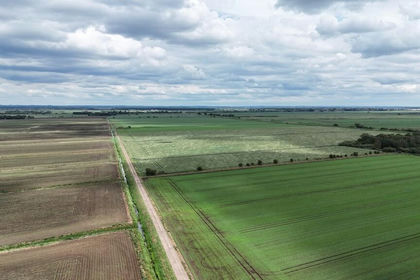
- Price
- Guide Price£160,000
- Size
- 21.2 acres
Added on 15/06/2026Farmland
- Price
- Guide Price£110,000
- Size
- 7.7 acres
Broad Lane, Skelton, Kilpin, East Riding of Yorkshire DN14 7RQ England
Added on 28/01/2026Grazing Land
- Price
- Guide Price£120,000
- Size
- 11.29 acres
11.29 acres, Great Hatfield, Hornsea, Hatfield, East Riding of Yorkshire HU11 4UY England
Added on 29/01/2026Arable Land
- Price
- Guide Price£130,000
- Size
- 12.87 acres
Added on 12/02/2026Farmland
- Price
- Guide Price£120,000
- Size
- 6.9 acres
6.90 Acres of Pastureland off Horbling Lane, Stickney, Stickney, Lincolnshire PE22 8DQ England
Added on 16/05/2026Vacant Land