Approximately 10.75 acres of land and a Building at Ystradfellte, Aberdare, CF44 9JF
- Land size
- 10.75 acres
Key Features
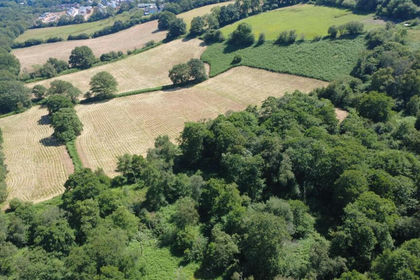
- Approximately 10.75 acres of pastureland and woodland
- Useful steel portal framed building
- Rural location between Penderyn and Ystradfellte
- Outskirts of the Brecon Beacons National Park
- Planning consent granted for 4 tourism pods
- Close proximity to A465 and A470
- Leasehold Interest (over 950 years left on the lease).
Description
Situation
Located on the outskirts of the village of Ystradfellte and within the breathtaking landscape of the Brecon Beacons National Park, the property is in close proximity to a number of road networks such as the A465 and A470.
The property is surrounded by scenic trails, bridleways, and woodland walks, including a popular route featuring six stunning waterfalls and is a magnet for outdoor enthusiasts, making the tourism pods a potentially lucrative venture.
Description
Extending to approximately 10.75 acres, the land is split into a number of conveniently sized parcels (each with its own water supply) and is ideally suited for equestrian use or smallholding.
The land includes a recently constructed 75ft x 30ft steel portal framed agricultural building.
A portion of the land amounting to approximately 1.75 acres benefits from full planning permission for the development of four tourism pods (Planning Ref: 22/21362/FUL).
Access
Access to the land is directly off a public maintained road.
Plan
The plans attached to these particulars are shown for identification purposes only and, whilst every care has been taken, its contents cannot be guaranteed.
Services
The land has a mains water connection.
Basic Payment Scheme
The land is being sold without the benefit of Basic Payment Scheme Entitlements.
Tenure and Possession
Leasehold with Vacant Possession upon completion. Further details on the leasehold title are available from the Selling Agents.
Boundaries
The purchaser(s) shall be deemed to have full knowledge of all boundaries and neither the vendor nor the vendors agents will be responsible for defining the boundaries of the ownership thereof.
The responsibility for boundary maintenance where known, is shown by inward facing ‘T’ marks on the sale plan.
Wayleave/Easements/Rights of Way
The property is being sold subject to and with the benefit of all rights including: rights of way, whether public or private, light, support, drainage, water and electricity supplies and other rights and obligations, easements and quasi-easements and restrictive covenants and all existing and proposed wayleaves for masts, pylons, stays, cables, drains, water and gas and other pipes whether referred to in these particulars or not. The property is subject to a right of way on foot in favour of the adjoining landowner. This is indicated by the purple line on the attached site plan.
Disputes
Should any dispute arise as to the boundaries or any point arising in the General Remarks and Stipulations or Particulars of Scale, Schedule, Plan or interpretation of any of them, the question shall be referred to the arbitration of the selling agents, whose decision acting as expert shall be final.
Plans, Areas & Schedules
These have been prepared as carefully as possible and are based on the Land Registry Plans. The plans are published for illustrative purposes only and although they are believed to be correct, their accuracy is not guaranteed.
Health and Safety
Given the potential hazards of agricultural land we ask you to be as vigilant as possible when making your inspection for your own personal safety.
Guide Price
£175,000
Method of Sale
For Sale by Private Treaty.
Directions
Postcode: CF44 9JF
What3Words: ///scout.measuring.clothed
From Hirwaun take the A4059 north. After approximately 3.5 miles, bear left (signposted Ystradfellte). Continue for a further 1.5 miles before turning left. Follow the road for a further 1 mile and the land can be found on the left, as shown by the Herbert R Thomas Sale Board.
Disclaimer
These particulars are provided as a general guide only and do not form part of any contract or offer. While believed to be accurate, they are not guaranteed. Some images may include CGI or digitally enhanced furnishings for illustrative purposes only and are not included in the sale. All negotiations must be conducted through Herbert R Thomas.
Map Location
Property details
- Tenure
- Leasehold
- Council Tax Band
- Ask Agent
- Date Posted
- 2026-03-18
Market Value Analysis
Compared with 154 Farmland & Pasture listings in Wales (10+ acres).
Utilities & Restrictions
Utilities
- Electricity
- Ask Agent
- Water
- Mains
- Heating
- Ask Agent
- Broadband
- Ask Agent
- Sewerage
- Ask Agent
Rights & Restrictions
- Public Rights of Way
- Ask Agent
- Private Rights of Way
- Ask Agent
- Listed Property
- Ask Agent
- Restrictions
- Ask Agent
Property Features
- Accessibility
- Ask Agent
- Parking
- Ask Agent
- Garden
- Ask Agent
Important notice: Information, maps and tags on this page are supplied by the advertising agent or generated automatically. LandSale has not verified them. Relying on these details is at your own risk, always carry out independent checks before committing to a purchase.
LandSale full disclaimer
Marketing information only - not formal particulars. The details on this website are provided for general guidance and do not constitute an offer or contract. Neither LandSale nor the advertising estate/land agent accepts responsibility for any inaccuracy.
1. Source of information
- Agent-supplied content: Core description, asking price, tenure, measurements, photographs and planning history are uploaded by the appointed agent, who remains solely responsible for their accuracy.
- Automated tags & categorisation: Property type, land-use class, acreage bands and similar labels may be applied by machine-learning models. They are intended as a helpful guide only and may not reflect the property's legal status or permitted use.
- Third-party & enriched data layers: Maps, boundary outlines, planning designations, soil reports, broadband coverage and other environmental or location-based insights are licensed from external suppliers. Such data are supplied “as is", may be incomplete or out of date and are subject to change without notice.
2. Verification required
Prospective purchasers must verify critical matters, including but not limited to planning permission, title boundaries, public rights of way, environmental constraints, acreage, services, access and VAT status, through their own inspections, specialist surveys, legal advisers and the selling agent before relying on the information or entering into any contract.
3. No warranty or liability
LandSale gives no warranty, express or implied, as to the accuracy, completeness or fitness for any particular purpose of the information displayed. LandSale shall not be liable for any loss, damage, cost or expense arising directly or indirectly from any use of or reliance on such information, save where liability may not be excluded by law.
4. Updates & feedback
If you believe any detail on this listing is inaccurate, please let us know. We will investigate and, where appropriate, update the listing or notify the agent.
© LandSale | Version 1.2 - January 2026
Listing agent
Herbert R Thomas, Cowbridge
59 High Street, Cowbridge, CF71 7YL
Similar properties for sale
- Price
- Guide Price£145,000
- Size
- 22.52 acres
Added on 16/07/2026Pasture
- Price
- £142,500
- Size
- 16.88 acres
Talley, Llandeilo, SA19, Talley, Carmarthenshire SA19 7BQ Wales
Added on 29/01/2026Farmland
- Price
- Guide Price£185,000
- Size
- 12.71 acres
Llanblethian, Cowbridge, CF71, Cowbridge with Llanblethian, Vale of Glamorgan CF71 7BH Wales
Added on 22/06/2026Farmland
- Price
- Guide Price£200,000
- Size
- 6.06 acres
Added on 20/03/2026Agricultural Land
- Price
- Offers in Region of£160,000
- Size
- 11.63 acres
Michaelston-Y-Fedw, Cefn Mably, Rudry, Caerphilly CF83 3DD Wales
Added on 29/01/2026Grazing Land
- Price
- Guide Price£200,000
- Size
- 18.86 acres
Land at Cwrt Bach, Henllys, Cwmbran, NP44 7AZ, Henllys, Torfaen NP44 7AZ Wales
Added on 04/06/2026Pasture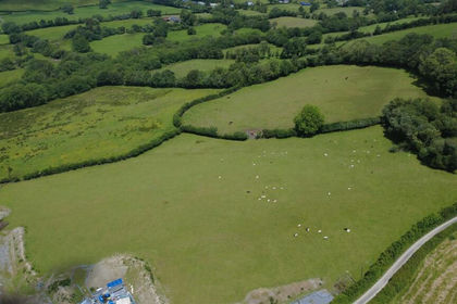
- Price
- Offers Over£150,000
- Size
- 19.6 acres
Ffarmers, Near Lampeter, Cynwyl Gaeo, Carmarthenshire SA19 8JW Wales
Added on 13/06/2026Farmland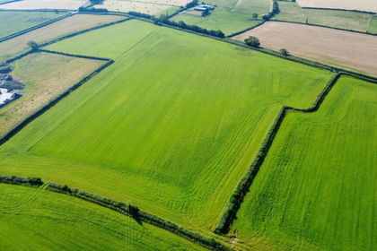
- Price
- Guide Price£170,000
- Size
- 16.55 acres
Added on 26/06/2026Farmland
- Price
- £180,000
- Size
- 18.5 acres
Capel Dewi, Carmarthen, SA32, Llanarthney, Carmarthenshire SA32 8AD Wales
Added on 29/01/2026Grazing Land
- Price
- £165,000
- Size
- 14.2 acres
Cwmann, Lampeter, SA48, Pencarreg, Carmarthenshire SA48 8EG Wales
Added on 15/03/2026Farmland