Land South Of Warton Recreation Ground, Orton Road/Barn End Road, Warton, B79 0HU
- Land size
- 13.99 acres
Key Features
- An opportunity to purchase a residential development site for 110 dwellings
- Data Room:
- Closing Date for Bids: By 12.00 noon on 5th May 2026
- Located to the north of the Warwickshire village of Warton.
Description
An opportunity to purchase a residential development site for 110 dwellings
Data Room:
Closing Date for Bids: By 12.00 noon on 5th May 2026
Located to the north of the Warwickshire village of Warton.
Residential Development Opportunity At:
Church Road
Warton
Warwickshire
For Sale on Behalf Of:
Messrs Caton and Richborough
Detailed Description
Summary:
An opportunity to purchase a residential development site, which is situated in Warton within the Borough of North Warwickshire, with planning consent "for the erection of 110 dwellings including public open space, drainage, landscaping and associated infrastructure". Shaded Red on the accompanying plan.
Planning:
An Appeal was allowed by the Planning Inspectorate - Appeal Reference: APP/R3705/W/25/3371526 (Decision Date: 16th February 2026) - The original Application Reference being PAP/2025/0155.The original application was taken to appeal due to the Council's failure to give notice within the prescribed period of a decision. The appeal decision was allowed for 'outline planning…for the construction of up to 110 dwellings with access, landscape, sustainable drainage features and associated infrastructure. All matters reserved except for the primary vehicular access from Church Road at Land South of Warton Recreation Ground.'
Description:
The site comprises a single field parcel extending to approximately 13.99 acres (5.66 hectares). At present, the site is agricultural land with a small area of woodland. The proposed access strategy will be via a new access from Church Road on the Northern boundary. The boundaries are predominately defined by existing hedgerows interspersed with trees.
The net site area is in the region of 6.81 acres (2.76 hectares) with the site being 40% affordable housing.
Location
Location of the Site:
The site is sustainably located to the north of the Warwickshire village of Warton.
Warton is located approximately 5 miles from Tamworth, with good access to junctions 10 if the M42, and A5 leading directly to the M69 and M1 motorways. Warton is an established commuter village with a range of amenities and a primary school. Tamworth can be reached in the car in approximately 15 minutes linking the area to Birmingham by train in 20 minutes and Coventry in 43 minutes.
Map Location
Property details
- Tenure
- Ask Agent
- Council Tax Band
- Ask Agent
- Date Posted
- 2026-03-18
Utilities & Restrictions
Utilities
- Electricity
- Ask Agent
- Water
- Ask Agent
- Heating
- Ask Agent
- Broadband
- Ask Agent
- Sewerage
- Ask Agent
Rights & Restrictions
- Public Rights of Way
- Ask Agent
- Private Rights of Way
- Ask Agent
- Listed Property
- Ask Agent
- Restrictions
- Ask Agent
Property Features
- Accessibility
- Ask Agent
- Parking
- Ask Agent
- Garden
- Ask Agent
Important notice: Information, maps and tags on this page are supplied by the advertising agent or generated automatically. LandSale has not verified them. Relying on these details is at your own risk, always carry out independent checks before committing to a purchase.
LandSale full disclaimer
Marketing information only - not formal particulars. The details on this website are provided for general guidance and do not constitute an offer or contract. Neither LandSale nor the advertising estate/land agent accepts responsibility for any inaccuracy.
1. Source of information
- Agent-supplied content: Core description, asking price, tenure, measurements, photographs and planning history are uploaded by the appointed agent, who remains solely responsible for their accuracy.
- Automated tags & categorisation: Property type, land-use class, acreage bands and similar labels may be applied by machine-learning models. They are intended as a helpful guide only and may not reflect the property's legal status or permitted use.
- Third-party & enriched data layers: Maps, boundary outlines, planning designations, soil reports, broadband coverage and other environmental or location-based insights are licensed from external suppliers. Such data are supplied “as is", may be incomplete or out of date and are subject to change without notice.
2. Verification required
Prospective purchasers must verify critical matters, including but not limited to planning permission, title boundaries, public rights of way, environmental constraints, acreage, services, access and VAT status, through their own inspections, specialist surveys, legal advisers and the selling agent before relying on the information or entering into any contract.
3. No warranty or liability
LandSale gives no warranty, express or implied, as to the accuracy, completeness or fitness for any particular purpose of the information displayed. LandSale shall not be liable for any loss, damage, cost or expense arising directly or indirectly from any use of or reliance on such information, save where liability may not be excluded by law.
4. Updates & feedback
If you believe any detail on this listing is inaccurate, please let us know. We will investigate and, where appropriate, update the listing or notify the agent.
© LandSale | Version 1.2 - January 2026
Listing agent
BROWN & CO-PROPERTY AND BUSINESS CONSULTANTS LLP, Leicester
Contact BROWN & CO-PROPERTY AND BUSINESS CONSULTANTS LLP, Leicester
View agent profileSimilar properties for sale

- Price
- POA
- Size
- 12.82 acres
Added on 20/05/2026Development Land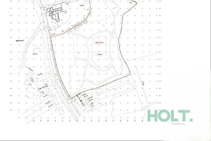
- Price
- POA
- Size
- 9.89 acres
Added on 04/07/2026Development Land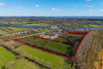
- Price
- POA
- Size
- 14.54 acres
Land at Cliffe Lane, Markfield, LE67 9PP, Markfield, Leicestershire LE67 9PP England
Added on 17/07/2026Development Land
- Price
- Offers in Region of£1,000,000
- Size
- 15 acres
Bumble Bee Lane, Leicestershire, LE10, Sharnford, Leicestershire LE10 3AE England
Added on 25/03/2026Building Plot
- Price
- POA
- Size
- 44.08 acres
Added on 17/07/2026Vacant Land
- Price
- POA
- Size
- 44.08 acres
Land at Highfields North, Walsall Wood, Aldridge-Brownhills, Walsall WS9 9AL England
Added on 17/07/2026Development Land
- Price
- POA
- Size
- 21.1 acres
Added on 29/01/2026Development Land
- Price
- £7,000,000
- Size
- 153.8 acres
Great Barr, Walsall, B43, Aldridge-Brownhills, Walsall B43 7BB England
Added on 06/03/2026Development Land
- Price
- POA
- Size
- 92.22 acres
Ryders Mere, Pelsall, Walsall WS3 4PU, Aldridge-Brownhills, Walsall WS3 4PU England
Added on 17/07/2026Development Land
- Price
- POA
- Size
- 92.22 acres
Ryders Mere, Pelsall, Walsall, Aldridge-Brownhills, Walsall WS3 4PU England
Added on 17/07/2026Vacant Land