Maybole Arms, 35/37 Kirkoswald Drive, Maybole, KA19
Key Features
- SAME OWNER FOR 22+ YEARS / FOR SALE DUE ONLY TO RETIREMENT / CONSISTENTLY PROFITABLE BUSINESS
- PRIME MAIN STREET LOCATION IN SOUGHT-AFTER VILLAGE / HIGH VISIBILITY & GOOD LEVEL OF FOOT TRAFFIC
- FULLY FITTED PREMISES WITH VALID LICENSE / TURNKEY FOR IMMEDIATE OPERATION
- WELL EQUIPPED KITCHEN / PERFECT FOR CATERING & ENHANCING REVENUE POTENTIAL
- ACCOMMODATES UP TO 60 COVERS AMPLE PRIVATE PARKING TO SIDE OF BUILDING / COUNCIL OWNED CAR PARK
- TWO-BEDROOM FLAT INCLUDED ON THE UPPER LEVEL PROVIDING POTENTIAL ON-SITE LIVING
- OUTDOOR REAR GARDEN SPACE INCLUDED WITH FLAT
- FREEHOLD OWNERSHIP / SALE WOULD BE PLUS STOCK AT VALUATION
- TRADITIONAL PUB WITH MASSES OF CHARACTER & CHARM / AUTHENTIC & WELCOMING ATMOSPHERE
- OPPORTUNITY TO TAP INTO LOYAL CUSTOMER BASE WITHIN LOCAL COMMUNITY
Description
Competitive Asking Price for this Profitable Business. SOUGHT-AFTER VILLAGE * TURNKEY OPERATION * ACCOMMODATES UP TO 60 COVERS * TWO-BEDROOM FLAT INCLUDED WITHIN SALE * FREEHOLD OWNERSHIP * Please contact your personal estate agents, The Property Boom to arrange a viewing.
Step into the heart of Maybole's community with the Maybole Arms, a unique opportunity to acquire a traditional village pub nestled along the main street. The property has had the same owner for 22 years and is only coming to the market due to retirement. This charming establishment boasts a prime location, offers visibility and draws in a steady stream of foot traffic.
In turnkey operation, the Maybole Arms presents fully fitted premises complete with a valid license, ensuring a seamless transition for immediate operation. The appeal continues with a fully equipped kitchen, perfect for catering and enhancing revenue potential with ease. With the ability to accommodate up to 60 covers, the pub provides ample seating and tables, catering to every preference, whether patrons seek a cosy corner for intimate conversation or a communal space to mingle.
A dedicated pool table area and darts board add to the pub's atmosphere, while bathroom facilities are available for both male and female patrons. Beyond the welcoming interior lies an upper two-bedroom flat, offering on-site living quarters comprising a fitted kitchen, lounge, two spacious bedrooms, a four-piece bathroom, and an office area. The fully enclosed rear garden space accompanying the flat provides opportunities for al fresco dining or a perfect space for pets.
Ownership of the Maybole Arms is secured with freehold status, affirming its' status as a beloved fixture within the local community. Revel in the pub's traditional ambiance, exuding character and charm that welcomes customers with open arms, fostering a sense of authenticity and warmth. Additionally, the building, approximately 200 years old, adds to its historic charm.
Seize the opportunity to tap into a loyal customer base eager to embrace the Maybole Arms. With ample parking at the side of the building and a large council-owned car park right next to the pub, convenience is ensured for patrons. This property offers endless possibilities for those with a discerning eye for charm and opportunity.
Painting by Stan Milne Art & available to purchase on Etsy.
WOULD YOU LIKE HELP WITH THE MARKETING OF YOUR OWN PROPERTY? TAKE ADVANTAGE OF OUR DECADES OF EXPERIENCE FROM OUR FRIENDLY AND APPROACHABLE TEAM. WE CUT THROUGH THE JARGON AND GIVE YOU SOLID ADVICE ON HOW AND WHEN TO SELL YOUR PROPERTY.
THESE PARTICULARS ARE ISSUED IN GOOD FAITH BUT DO NOT CONSTITUTE REPRESENTATIONS OF FACT OR FORM PART OF ANY OFFER OR CONTRACT.
GROUND FLOOR ROOM DIMENSIONS (PUB)
Bar Area
10.6m x 6m - 34'9" x 19'8"
Snug
3.7m x 3m - 12'2" x 9'10"
Gents Bathroom
3.9m x 2.8m - 12'10" x 9'2"
Ladies Bathroom
3.3m x 1.7m - 10'10" x 5'7"
Kitchen
4.4m x 2.2m - 14'5" x 7'3"
Cellar
7.1m x 2.3m - 23'4" x 7'7"
FIRST FLOOR ROOM DIMENSIONS (FLAT)
Lounge
6m x 4.5m - 19'8" x 14'9"
Kitchen
2.9m x 2.3m - 9'6" x 7'7"
Bedroom One
3.7m x 3.6m - 12'2" x 11'10"
Bedroom Two
3.3m x 2.3m - 10'10" x 7'7"
Office
4.3m x 2.4m - 14'1" x 7'10"
Bathroom
5m x 1.6m - 16'5" x 5'3"
Map Location
Property details
- Tenure
- Freehold
- Council Tax Band
- B
- Date Posted
- 2026-03-06
Energy Performance Certificate
Energy Efficiency Rating
Based on UK Energy Performance Certificate standards (EU Directive 2002/91/EC)
Running costs are one side. Planning activity, flood history and ground risks for this location are in the full report.
Utilities & Restrictions
Utilities
- Electricity
- Ask Agent
- Water
- Ask Agent
- Heating
- Ask Agent
- Broadband
- Ask Agent
- Sewerage
- Ask Agent
Rights & Restrictions
- Public Rights of Way
- Ask Agent
- Private Rights of Way
- Ask Agent
- Listed Property
- Ask Agent
- Restrictions
- Ask Agent
Listed status, conservation areas and planning constraints for this location are in the full report.
Property Features
- Accessibility
- Ask Agent
- Parking
- Parking Available
- Garden
- Garden
Beyond the particulars: planning activity, flood history, heritage and ground risks, checked for this exact spot.
Connectivity
Broadband
Fastest speed available at this postcode
10 Gbps
Gigabit full fibre
Suitable for
- 4K streaming on every screen
- Full-time home working
- Online gaming & big downloads
Mobile signal
Predicted 4G and 5G signal; indoor signal depends on building materials.
Ofcom Connected Nations postcode-level predictions. Speeds and signal are modelled, not measured, and vary between addresses and providers.
Signal is the easy part. Planning activity, flood history and protected designations here are in the full report.
Nearest Schools
Primary
- Culzean Primary School and Early Years Centre666 metres
- Pupils
- 288
- Type
- Non-denominational
- St Cuthbert's Primary School666 metres
- Pupils
- 38
- Type
- Roman Catholic
- Crosshill Primary School2.6 miles
- Pupils
- 31
- Type
- Non-denominational
- Kirkmichael Primary School2.9 miles
- Pupils
- 34
- Type
- Non-denominational
- Minishant Primary School3.1 miles
- Pupils
- 22
- Type
- Non-denominational
Secondary
- Carrick Academy666 metres
- Pupils
- 391
- Type
- Non-denominational
- Belmont Academy6.9 miles
- Pupils
- 1,211
- Type
- Non-denominational
- Queen Margaret Academy7 miles
- Pupils
- 681
- Type
- Roman Catholic
- South Ayrshire Council Virtual School7.8 miles
- Type
- Non-denominational
- Ayr Academy8 miles
- Pupils
- 602
- Type
- Non-denominational
Distances are straight-line from the advertised location. Source: the national school registers (DfE, Welsh Government, Scottish Government) and Ofsted.
Schools are just the start: planning activity, heritage and any flood history here are in the full report.
Amenities
Supermarket
GP surgery
Pharmacy
Green space
Straight-line distances from the advertised location. Sources: NHS records, Geolytix supermarket locations, OS Open Greenspace and the national trails registers.
The area stacks up? Now check the location itself: planning nearby, protected designations and past flooding.
Getting Around
Nearest station
Nearest bus stop
Typical drive times
Straight-line distances from the advertised location; drive times are typical free-flow times over OpenStreetMap road data, so allow more at peak. Public transport locations from DfT NaPTAN.
Easy to reach matters. So do planning activity, flood history and ground risks: all in the full report.
Flood Risk
SEPA open data, checked around the advertised map pin for the listed acreage. The map pin for this listing marks the postcode area rather than the exact location, so these readings describe the surrounding area. Provided by LandSale, not the listing agent, and not part of the agent's particulars. Risk varies across a holding, so verify before committing.
Rivers and the sea
Surface water
Not at the pin: mapped about 20 metres away.
These bandings are the summary. Where this location sits on the flood maps, plus planning activity, heritage and ground risks, is in the full report.
Important notice: Information, maps and tags on this page are drawn from the advertising agent's marketing materials or generated automatically. LandSale has not verified them. Relying on these details is at your own risk, always carry out independent checks before committing to a purchase.
LandSale full disclaimer
Marketing information only - not formal particulars. The details on this website are provided for general guidance and do not constitute an offer or contract. Neither LandSale nor the advertising estate/land agent accepts responsibility for any inaccuracy.
1. Source of information
- Listing content: Core description, asking price, tenure, measurements, photographs and planning history originate from the marketing materials of the advertising estate or land agent. LandSale does not author this content and cannot guarantee its accuracy.
- Automated tags & categorisation: Property type, land-use class, acreage bands and similar labels may be applied by machine-learning models. They are intended as a helpful guide only and may not reflect the property's legal status or permitted use.
- Third-party & enriched data layers: Maps, boundary outlines, planning designations, soil reports, broadband coverage and other environmental or location-based insights are licensed from external suppliers. Such data are supplied “as is", may be incomplete or out of date and are subject to change without notice.
2. Verification required
Prospective purchasers must verify critical matters, including but not limited to planning permission, title boundaries, public rights of way, environmental constraints, acreage, services, access and VAT status, through their own inspections, specialist surveys, legal advisers and the selling agent before relying on the information or entering into any contract.
3. No warranty or liability
LandSale gives no warranty, express or implied, as to the accuracy, completeness or fitness for any particular purpose of the information displayed. LandSale shall not be liable for any loss, damage, cost or expense arising directly or indirectly from any use of or reliance on such information, save where liability may not be excluded by law.
4. Updates & feedback
If you believe any detail on this listing is inaccurate, please let us know. We will investigate and, where appropriate, update the listing or notify the agent.
© LandSale | Version 1.3 - August 2026
Listing agent
The Property Boom Limited, Ayrshire
31 Braehead, Beith, Ayrshire, Scotland KA15 1EG
Contact The Property Boom Limited, Ayrshire
31 Braehead, Beith, Ayrshire, Scotland KA15 1EG
View agent profileSimilar properties for sale
- Price
- Guide Price£155,000
9-11 Ladywell Road, Maybole, Ayrshire, KA19, Ayr, Carrick and Cumnock, South Ayrshire KA19 Scotland
Added on 24/04/2026Commercial Land- Price
- Guide Price£125,000
9-11 Ladywell Road, Maybole, Ayrshire, KA19, Ayr, Carrick and Cumnock, South Ayrshire KA19 Scotland
Added on 08/08/2026Pub
- Price
- Offers Over£250,000
High Street, Dalmellington, Ayr, KA6, Ayr, Carrick and Cumnock, East Ayrshire KA6 Scotland
Added on 14/03/2026Pub
- Price
- Offers in Excess of£129,000
- Size
- 0.15 acres
North Shore Plot, Beach Road, Barassie, KA10, Central Ayrshire, South Ayrshire KA10 Scotland
Added on 23/09/2026Development Land
- Price
- Offers in Excess of£110,000
Added on 18/07/2026Pub
- Price
- Offers in Region of£210,000
Bridge Street, Stranraer, DG9, Dumfries and Galloway, Dumfries and Galloway DG9 Scotland
Added on 28/01/2026Pub
- Price
- £210,000
- Size
- 0.09 acres
10 Lady Lane, Paisley, Renfrewshire, PA1, Paisley and Renfrewshire South, Renfrewshire PA1 Scotland
Added on 28/07/2026Industrial Land
- Price
- Guide Price£160,000
Added on 24/09/2026Pub
- Price
- Offers in Excess of£150,000
- Size
- 1.9 acres
Royston Road, Glasgow, G21, Glasgow North East, Glasgow City G21 Scotland
Added on 28/09/2026Industrial Land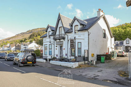
- Price
- £195,000
The Strone Inn, Strone, Dunoon, PA23, Argyll, Bute and South Lochaber, Argyll and Bute PA23 Scotland
Added on 17/07/2026Pub