Lot 3 - High Trees, Netherhill Lane, Botley SO32
- Land size
- 5.05 acres
Key Features
- SEE AND PRINT PDF SALES PARTICULARS AVAILABLE BELOW
- SEE DRONE VIDEO FOOTAGE ON THE VIRTUAL TOUR TAB
- LOT 3 - APPROX. 5.05 ACRES PASTURE LAND
- ADDITIONAL LOTS AVAILABLE
- ELEVATED PLOT OFF A QUIET LANE
- SOUTHERLY VIEWS ACROSS OPEN COUNTRYSIDE
- SHARED ACCESS - WATER AVAILABLE
- ROAD FRONTAGE
- WELL
Description
VIEWING INSTRUCTIONS:
CHALET BUNGALOW (LOT 1): STRICTLY BY PRIOR APPOINTMENT and to be accompanied by the Selling Agent. Contact .
PASTURE LAND (LOTS 2 - 4): Please proceed on foot over Gate as shown on Site Plan and unaccompanied during daylight hours and taking a set of these Sales Particulars with you. Please park either in the lay by on the lane to the south of Lot 4 or beside the gate on the verge so that the lane is not blocked.
It is essential to view the drone video footage available on the Selling Agent's website prior to visiting the Property.
VIDEO DRONE FOOTAGE: See the Selling Agent's website for further details, photographs, drone video footage is available showing the whole Property.
LOCATION: See Location Plan. The Property lies in an open area of countryside off a quiet lane between the village of Durley (to the north) and Boorley Green (to the southwest), with the market town of Bishops Waltham & the village of Botley approx. 2 miles away to the northeast and south respectively. The vehicular entrance to the Bungalow is (What3Words) SO32 3BP.
DIRECTIONS: See Location Plan. From Botley village centre, take the A334 eastwards towards Wickham. Immediately after Botley railway station and Railway Pub bear left onto the B3035 heading northeasterly towards Bishops Waltham. Take the left hand turn onto Wangfield Lane and after approx. ½ mile turn right on to Netherhill Lane heading north. Travel along Netherhill Lane for approx. a mile and High Trees can be found on your left, before the Post Box.
CHALET BUNGALOW OCCUPANCY CONDITION: The Chalet Bungalow was built shortly after Planning Consent was achieved on '3rd November 1960' for the erection of a bungalow for 'occupation by an Agricultural worker at Netherhill Farm'. Condition 1 of that consent states 'The occupation of the dwelling shall be limited to persons employed or last employed locally in agriculture as described in Section 119(1) of the Town and Country Planning Act, 1947, or in Forestry, and the dependents of such persons'. See copy of Consent on Selling Agent's website (poor quality).
A Purchaser is not required to necessarily have a history of employment or business in agriculture or forestry. There is the opportunity for a Purchaser to commence such activity to satisfy the condition, post completion.
Interested parties should investigate this matter and/or take guidance from a Planning Consultant or Solicitor.
PASTURE LAND (LOTS 2, 3 AND 4): The adjoining pasture extends to a total of 11.07 acres (4.48 Ha) and is surrounded by established hedgerows and currently served by a single gate as identified on the Site Plan. There is also an existing vehicular gate from the garden (Lot 1) into the pasture (Lot 2).
The existing gate off the lane is identified on Site Plan will serve both Lots 3 and 4. If Lot 2 is not sold with the Bungalow then access will also be required through the gate to benefit Lot 2.
Yellow wooden pegs are in position as identified on the Site Plan. Interested parties are able to propose alternative positions of Lotting boundaries to the Selling Agent if they wish.
The land is reasonably level at the northern end (Lot 2), then gently slopes down to the south (Lots 3 and 4).
The Geological Survey Map identifies that the subsoils are of 'Drift over Mesozoic and Tertiary clay and loam - Slowly permeable seasonally waterlogged fine loamy over clayey and coarse loamy over clayey soils' and the Land Classification Map indicates the land to be of Grade 1 and 2 quality. The land lies approximately between 20m and 30m above sea level.
LAND REGISTRY: The Property is currently registered and comprises two Titles HP890228 and HP873894. See Selling Agent's website for copies of the Plans and Registers.
TPOs: None affect the Property.
DEVELOPMENT UPLIFT: The Vendor may consider a Development Clause by which they could retain a share of any windfall of value caused by residential development that occurs on the land (Lots 2-4) in the distant future.
DESIGNATIONS: There are no environmental designations that affect the Property. The Property falls outside of the South Downs National Park (SDNP).
WAYLEAVES AND EASEMENTS: An overhead 33kv Electric Line crosses part of Lot 4 pasture. An 8" gas pipeline passes through the southern tip of Lot 4.
SERVICES: Private Septic Tank. Heating - Oil Boiler. Mains Water. Mains Electricity.
WELL: There is a well located in the pasture that historically served nearby residents. Its approximate position shown on the Site Plan. It is not currently in use.
BUNGALOW COUNCIL TAX: Council Tax Band D - 2025/26 Council Tax Charges £2,222.21
LOCAL AUTHORITY: Winchester City Council (WCC), City Offices, Colebrook Street, Winchester SO23 9LJ.
Map Location
Property details
- Tenure
- Freehold
- Council Tax Band
- Ask Agent
- Date Posted
- 2026-02-12
Market Value Analysis
Compared with 100 Farmland & Pasture listings in South East England (5+ acres).
Utilities & Restrictions
Utilities
- Electricity
- Ask Agent
- Water
- Ask Agent
- Heating
- Ask Agent
- Broadband
- Ask Agent
- Sewerage
- Ask Agent
Rights & Restrictions
- Public Rights of Way
- Ask Agent
- Private Rights of Way
- Ask Agent
- Listed Property
- Ask Agent
- Restrictions
- Ask Agent
Listed status, conservation areas and planning constraints for this location are in the full report.
Property Features
- Accessibility
- Ask Agent
- Parking
- Ask Agent
- Garden
- Garden
Beyond the particulars: planning activity, flood history, heritage and ground risks, checked for this exact spot.
Connectivity
Broadband
Fastest speed available at this postcode
1.8 Gbps
Gigabit full fibre · available to 5% of premises
Suitable for
- 4K streaming on every screen
- Full-time home working
- Online gaming & big downloads
Mobile signal
Predicted 4G and 5G signal; indoor signal depends on building materials.
Ofcom Connected Nations postcode-level predictions. Speeds and signal are modelled, not measured, and vary between addresses and providers.
Signal is the easy part. Planning activity, flood history and protected designations here are in the full report.
Nearest Schools
Primary
- Boorley Park953 metresOfsted: Good
- Ages
- 4 to 11
- Pupils
- 380
- Type
- Free schools
- Curdridge Primary School1 mileNo Ofsted rating
- Ages
- 4 to 11
- Pupils
- 110
- Type
- Community school
- Durley Church of England Controlled Primary School1 mileNo Ofsted rating
- Ages
- 4 to 11
- Pupils
- 139
- Type
- Voluntary controlled school
- Faith
- Church of England
- Botley Church of England Controlled Primary School1.4 milesOfsted: Good
- Ages
- 4 to 11
- Pupils
- 357
- Type
- Voluntary controlled school
- Faith
- Church of England
- Berrywood Primary School1.6 milesOfsted report card · Nov 2025
- Ages
- 4 to 11
- Pupils
- 631
- Type
- Community school
Secondary
- Deer Park School1.2 milesOfsted: Good
- Ages
- 11 to 16
- Pupils
- 910
- Type
- Free schools
- Wildern School2 milesOfsted: Good
- Ages
- 11 to 16
- Pupils
- 1,674
- Type
- Academy converter
- Wyvern College2.4 milesNo Ofsted rating
- Ages
- 11 to 16
- Pupils
- 1,313
- Type
- Academy converter
- Swanmore College3.3 milesNo Ofsted rating
- Ages
- 11 to 16
- Pupils
- 1,338
- Type
- Community school
- Woodlands Community College3.4 milesOfsted: Good
- Ages
- 11 to 16
- Pupils
- 907
- Type
- Foundation school
Distances are straight-line from the advertised location. Source: the national school registers (DfE, Welsh Government, Scottish Government) and Ofsted.
Schools are just the start: sold prices nearby, planning activity and any flood history are in the full report.
Amenities
Supermarket
GP surgery
Pharmacy
Hospital
Green space
Straight-line distances from the advertised location. Sources: NHS records, Geolytix supermarket locations, OS Open Greenspace and the national trails registers.
The area stacks up? Now check the location itself: planning nearby, protected designations and past flooding.
Getting Around
Nearest station
Nearest bus stop
Typical drive times
Straight-line distances from the advertised location; drive times are typical free-flow times over OpenStreetMap road data, so allow more at peak. Public transport locations from DfT NaPTAN.
Easy to reach matters. So do planning activity, flood history and ground risks: all in the full report.
Flood Risk
Environment Agency open data, checked around the advertised map pin for the listed acreage. Long-term risk counts flood defences; the planning map's flood zones do not. Provided by LandSale, not the listing agent, and not part of the agent's particulars. Risk varies across a holding, so verify before committing.
Rivers and the sea
Planning map: Flood Zone 1.
Surface water
Not at the pin: mapped about 70 metres away.
These bandings are the summary. Where this location sits on the flood maps, plus planning activity, heritage and ground risks, is in the full report.
Important notice: Information, maps and tags on this page are drawn from the advertising agent's marketing materials or generated automatically. LandSale has not verified them. Relying on these details is at your own risk, always carry out independent checks before committing to a purchase.
LandSale full disclaimer
Marketing information only - not formal particulars. The details on this website are provided for general guidance and do not constitute an offer or contract. Neither LandSale nor the advertising estate/land agent accepts responsibility for any inaccuracy.
1. Source of information
- Listing content: Core description, asking price, tenure, measurements, photographs and planning history originate from the marketing materials of the advertising estate or land agent. LandSale does not author this content and cannot guarantee its accuracy.
- Automated tags & categorisation: Property type, land-use class, acreage bands and similar labels may be applied by machine-learning models. They are intended as a helpful guide only and may not reflect the property's legal status or permitted use.
- Third-party & enriched data layers: Maps, boundary outlines, planning designations, soil reports, broadband coverage and other environmental or location-based insights are licensed from external suppliers. Such data are supplied “as is", may be incomplete or out of date and are subject to change without notice.
2. Verification required
Prospective purchasers must verify critical matters, including but not limited to planning permission, title boundaries, public rights of way, environmental constraints, acreage, services, access and VAT status, through their own inspections, specialist surveys, legal advisers and the selling agent before relying on the information or entering into any contract.
3. No warranty or liability
LandSale gives no warranty, express or implied, as to the accuracy, completeness or fitness for any particular purpose of the information displayed. LandSale shall not be liable for any loss, damage, cost or expense arising directly or indirectly from any use of or reliance on such information, save where liability may not be excluded by law.
4. Updates & feedback
If you believe any detail on this listing is inaccurate, please let us know. We will investigate and, where appropriate, update the listing or notify the agent.
© LandSale | Version 1.3 - August 2026
Listing agent
Giles Wheeler-Bennett, Southampton
West Court, Lower Basingwell Street, Bishop's Waltham, SO32 1AJ
View agent profileSimilar properties for sale
 Added on 04/09/2026Building Plot
- Price
- Guide Price£245,000
Mays Lane, Stubbington, PO14, Gosport, Hampshire PO14 England
Added on 29/01/2026Building Plot
- Price
- Guide Price£150,000
Crofton Lane, Fareham, PO14, Gosport, Hampshire PO14 England
Added on 11/03/2026Building Plot Added on 02/10/2026Building Plot
 Added on 02/10/2026Building Plot
- Price
- £150,000
New Build, The Close, Holbury, Southampton, Hampshire, SO45, Fawley, Hampshire SO45 England
Added on 04/10/2026Building Plot Added on 04/10/2026Building Plot
 Added on 29/01/2026Building Plot
- Price
- Guide Price£220,000
Norton Green, Isle of Wight, Freshwater, Isle of Wight PO40 England
Added on 29/01/2026Building Plot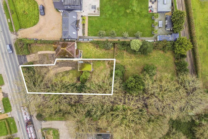
- Price
- Guide Price£245,000
Bell Lane, Birdham, West Sussex, PO20, Birdham, West Sussex PO20 England
Added on 19/05/2026Building Plot