Land At Burnbrae Road, Stoneyburn, Bathgate, EH47
- Land size
- 7.6 acres
Key Features
- Prime Development Opportunity
- Strategically positioned near the M8 & A71
- Centrally Located for Convenient Access to Both Glasgow and Edinburgh
- Agricultural Land Classified as Grade 3.2 and 4.2
Description
An exceptional opportunity to purchase a parcel of land with promising development potential, extending to approximately 7.6 acres and situated on the outskirts of Stoneyburn. The site is zoned for residential use, offering scope for future housing development.
Situation
Stoneyburn is a friendly village with a strong community feel and easy access to everyday amenities such as shops, schools, and local services. Well-connected by the A71 and M8, it offers convenient travel to Livingston, Edinburgh, and Glasgow, making it attractive to commuters. The surrounding countryside provides space for walking, cycling, and outdoor recreation, while nearby towns like Bathgate, Whitburn, and Addiewell offer additional facilities and rail links to the cities.
Nearest Postcode
EH47 8DF
Directions
The site benefits from access via both Burnbrae Road and Burnlea Drive, providing flexible entry points. This dual access is considered suitable to support future residential development, subject to the necessary consents. Should planning permission be secured for a scheme of approximately 30 dwellings, the land’s value is expected to increase significantly.
From Glasgow:
Take the M8 east from Glasgow, exit at Junction 4 (Whitburn), then follow signs for Stoneyburn via the B7015.
From Edinburgh:
Take the M8 west from Edinburgh, exit at Junction 3A (Bathgate/Blackburn), then follow the A705 and B7015 toward Stoneyburn.
Access to the land is taken from Burnbrae Road or from Burnlea Drive.
Description
This attractive parcel of land lies at the end of Burnbrae Road in the village of Stoneyburn and is identified in the adopted West Lothian Local Development Plan as site H-SB6. The site is zoned for residential use with an indicative capacity for 30 dwellings, offering a strong opportunity for future development, subject to planning consent. No formal planning applications have been submitted to date.
Historically used for grazing, the land has more recently served as an informal recreational space for the local community and is intersected by a network of footpaths, including one that enters from the south. Access is available via both Burnbrae Road and Burnlea Drive, providing flexibility for future infrastructure and layout. The site’s residential zoning, together with its accessible location and established entry points, presents strong potential for increased land value should planning permission be secured.
Land
The site extends to approximately 7.6 acres and is classified as having moderate agricultural capability under Scotland’s soil maps.
Tenure
The land is offered for sale as a heritable title.
Planning & Development
The full planning history summary with regards to the property can be provided upon request. Prospective purchasers should make their own investigations into the planning consents and all relevant information including looking at the local authority planning portal. It is recommended that those interested seek appropriate professional advice. It may be that other uses for the site could be considered and prospective purchasers should make their own enquiries accordingly and any such use would be dependent on obtaining the relevant permissions.
Map Location
Property details
- Tenure
- Freehold
- Council Tax Band
- TBC
- Date Posted
- 2026-02-04
Market Value Analysis
Compared with 49 Development Land listings in Scotland (5+ acres).
Utilities & Restrictions
Utilities
- Electricity
- Ask Agent
- Water
- Ask Agent
- Heating
- Ask Agent
- Broadband
- Ask Agent
- Sewerage
- Ask Agent
Rights & Restrictions
- Public Rights of Way
- Yes
- Private Rights of Way
- Ask Agent
- Listed Property
- Ask Agent
- Restrictions
- Ask Agent
Property Features
- Accessibility
- Ask Agent
- Parking
- Parking Available
- Garden
- Ask Agent
Important notice: Information, maps and tags on this page are supplied by the advertising agent or generated automatically. LandSale has not verified them. Relying on these details is at your own risk, always carry out independent checks before committing to a purchase.
LandSale full disclaimer
Marketing information only - not formal particulars. The details on this website are provided for general guidance and do not constitute an offer or contract. Neither LandSale nor the advertising estate/land agent accepts responsibility for any inaccuracy.
1. Source of information
- Agent-supplied content: Core description, asking price, tenure, measurements, photographs and planning history are uploaded by the appointed agent, who remains solely responsible for their accuracy.
- Automated tags & categorisation: Property type, land-use class, acreage bands and similar labels may be applied by machine-learning models. They are intended as a helpful guide only and may not reflect the property's legal status or permitted use.
- Third-party & enriched data layers: Maps, boundary outlines, planning designations, soil reports, broadband coverage and other environmental or location-based insights are licensed from external suppliers. Such data are supplied “as is", may be incomplete or out of date and are subject to change without notice.
2. Verification required
Prospective purchasers must verify critical matters, including but not limited to planning permission, title boundaries, public rights of way, environmental constraints, acreage, services, access and VAT status, through their own inspections, specialist surveys, legal advisers and the selling agent before relying on the information or entering into any contract.
3. No warranty or liability
LandSale gives no warranty, express or implied, as to the accuracy, completeness or fitness for any particular purpose of the information displayed. LandSale shall not be liable for any loss, damage, cost or expense arising directly or indirectly from any use of or reliance on such information, save where liability may not be excluded by law.
4. Updates & feedback
If you believe any detail on this listing is inaccurate, please let us know. We will investigate and, where appropriate, update the listing or notify the agent.
© LandSale | Version 1.2 - January 2026
Listing agent
Davidson & Robertson, Edinburgh
The Rural Centre West Mains Ingliston Edinburgh EH28 8LT
Contact Davidson & Robertson, Edinburgh
The Rural Centre West Mains Ingliston Edinburgh EH28 8LT
View agent profileSimilar properties for sale

- Price
- Offers Over£150,000
- Size
- 24.3 acres
Added on 15/07/2026Development Land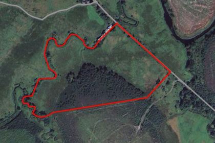
- Price
- £169,000
- Size
- 31.38 acres
Land at Easterhill, Gartmore, Stirling, FK8 3SA, Stirling and Strathallan, Stirling FK8 3SA Scotland
Added on 10/06/2026Grazing Land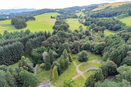
- Price
- Offers Over£250,000
- Size
- 4 acres
Added on 14/07/2026Self Build Plot
- Price
- Offers Over£180,000
- Size
- 1.3 acres
Added on 29/01/2026Building Plot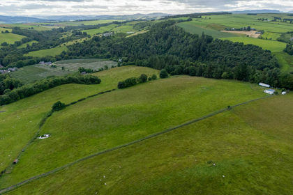
- Price
- Offers Over£160,000
- Size
- 15.56 acres
Added on 14/07/2026Agricultural Land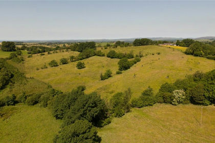
- Price
- £150,000
- Size
- 42.89 acres
Lot 2 Land At Hopes House, Penton, Carlisle, CA6, Solport, Cumberland CA6 5RT England
Added on 07/07/2026Vacant Land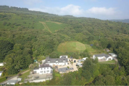
- Price
- Offers in Region of£150,000
- Size
- 23.47 acres
Added on 13/05/2026Farm
- Price
- Offers Over£200,000
- Size
- 111.2 acres
Added on 29/06/2026Undeveloped Land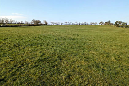
- Price
- £150,000
- Size
- 12.6 acres
Land and Building At Lyneholmford, Roweltown, Carlisle, Stapleton, Cumberland CA6 6LH England
Added on 29/01/2026Grazing Land