Burnfield Farm, The Hill, Millom, Cumbria, LA18
- Land size
- 14.14 acres
- Bedrooms
- 3
- Bathrooms
- 1
Description
Set in a peaceful, semi-rural location this three-bedroom detached farmhouse presents an exciting opportunity. The farmstead comprises of farm buildings, an orchard, lawned garden along with approximately 14.14 acres of agricultural land.
The land at Burnfield Farm extends to a total of 14.14 acres (5.72 hectares) of meadow and pastureland, which is split into several parcels. The parcels of land are good meadow and pasture land, which are ring fenced around the farm steading.
Having easy access to the town of Millom, and with good transport links to Barrow and Whitehaven, this property is ideally situated.
Due to the nature and location of the property we believe it will be of high interest to a variety of individuals, particularly for local farmers and small holders.
The farmhouse is now in need of a course of upgrading and modernisation throughout and the accommodation briefly comprises;
Entrance Hall, with a door to the front and rear of the property.
Living Room, which is currently used as a dining room with dual aspect windows.
Dining Room, a small room that is currently used for storage purposes.
Kitchen, with fitted wall and base units with space for a dining table.
First Floor
Bedroom One, a very large double bedroom with dual aspect windows.
Bedroom Two, a double bedroom.
Bedroom Three, a double bedroom with a built-in cupboards housing the water tank.
Bathroom, comprising of a toilet, sink and shower cubicle.
Externally
To the immediate rear of the farmhouse is an orchard and lawned garden.
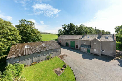
Farm Buildings
There are a range of traditional farm buildings on the farmstead, comprising:
A traditional stone barn under a slate roof, located adjacent to the farmhouse. This barn offers the potential to be developed into a range of uses, subject to relevant planning permission.
A set of stone buildings under a tile roof, which are currently used for storage purposes. Attached to the stone buildings there is a block-built storage area.
There is also a brick built former stable and a line of timber framed buildings and a dutch barn.
Land at Burnfield Farm
The land at Burnfield Farm extends to a total of 14.14 acres (5.72 hectares) of meadow and pastureland, which is split into several parcels.
The parcels of land are ring fenced around the farm steading.
Tenure:
Freehold.
Wayleaves/Easement:
The property and land is sold subject to, and with the benefit of, all rights of way, whether public or private, any existing or proposed wayleaves, easements or quasi easements, whether referred to within these particulars or not. There is an unadopted gravel road that the property is accessed over.
Services:
The property is connected to mains Electricity and Water with private drainage.
Environmental Schemes
There are currently no Environmental Schemes or grants on the property at the present time.
Water
There is currently no water supply to the land
Local Authority:
Copeland Council.
Council Tax:
Band D
Health and Safety
Viewers should bear in mind the risk associated with land and property, as well as any livestock or wildlife that may be present at time of viewing.
We recommend all viewers wear appropriate clothing and footwear to minimise the risks associated with viewing land and property.
The access to the property is via an unadopted road, viewers must be cautious when driving along the road.
Energy Performance Certificate
To be added
Location:
‘Burnfield Farm’ is situated in a rural location close to The Hill near Millom and is accessed off Aggie’s Lonnin, an unadopted gravel road. The rural location yet still in close distance to the towns of Millom and Broughton in Furness make this farm an attractive proposition.
Inspections:
By appointment only with the selling agent, UAM Property.
Directions:
From Greenodd, follow the A5092 towards Millom. At Grizebeck continue onto the A595 towards Millom and follow directions to Millom on the A5903. On the approach to Millom, as soon as you pass the Welcome to Millom sign, take a sharp left turn, and slightly go back on yourself. This takes you onto Aggie’s Lonnin. Continue along here for a short distance and the property can be found on the left hand side, as marked by our For Sale board.
What3Words ///trinkets.terminology.jugs
Map Location
Property details
- Tenure
- Ask Agent
- Council Tax Band
- D
- Date Posted
- 2026-01-28
Market Value Analysis
Compared with 61 Farms & Smallholdings listings in North West England (10+ acres).
Utilities & Restrictions
Utilities
- Electricity
- Ask Agent
- Water
- Ask Agent
- Heating
- Ask Agent
- Broadband
- Ask Agent
- Sewerage
- Ask Agent
Rights & Restrictions
- Public Rights of Way
- Ask Agent
- Private Rights of Way
- Ask Agent
- Listed Property
- Ask Agent
- Restrictions
- Ask Agent
Property Features
- Accessibility
- Ask Agent
- Parking
- Ask Agent
- Garden
- Garden
Important notice: Information, maps and tags on this page are supplied by the advertising agent or generated automatically. LandSale has not verified them. Relying on these details is at your own risk, always carry out independent checks before committing to a purchase.
LandSale full disclaimer
Marketing information only - not formal particulars. The details on this website are provided for general guidance and do not constitute an offer or contract. Neither LandSale nor the advertising estate/land agent accepts responsibility for any inaccuracy.
1. Source of information
- Agent-supplied content: Core description, asking price, tenure, measurements, photographs and planning history are uploaded by the appointed agent, who remains solely responsible for their accuracy.
- Automated tags & categorisation: Property type, land-use class, acreage bands and similar labels may be applied by machine-learning models. They are intended as a helpful guide only and may not reflect the property's legal status or permitted use.
- Third-party & enriched data layers: Maps, boundary outlines, planning designations, soil reports, broadband coverage and other environmental or location-based insights are licensed from external suppliers. Such data are supplied “as is", may be incomplete or out of date and are subject to change without notice.
2. Verification required
Prospective purchasers must verify critical matters, including but not limited to planning permission, title boundaries, public rights of way, environmental constraints, acreage, services, access and VAT status, through their own inspections, specialist surveys, legal advisers and the selling agent before relying on the information or entering into any contract.
3. No warranty or liability
LandSale gives no warranty, express or implied, as to the accuracy, completeness or fitness for any particular purpose of the information displayed. LandSale shall not be liable for any loss, damage, cost or expense arising directly or indirectly from any use of or reliance on such information, save where liability may not be excluded by law.
4. Updates & feedback
If you believe any detail on this listing is inaccurate, please let us know. We will investigate and, where appropriate, update the listing or notify the agent.
© LandSale | Version 1.2 - January 2026
Similar properties for sale
- Price
- Guide Price£575,000
- Size
- 2.31 acres
Woodside House, Waberthwaite, Millom, Cumbria, LA19, Waberthwaite, Cumberland CA18 1RS England
Added on 29/01/2026Farmhouse
- Price
- Guide Price£625,000
- Size
- 42 acres
Ellershaw Farm, Halton Gill, Skipton, BD23 5QN, Halton Gill, North Yorkshire BD23 5QN England
Added on 29/01/2026Farm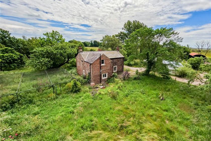
- Price
- Guide Price£320,000
- Size
- 1.26 acres
Whitehill, Saltcoats, Kirkbride, Wigton, Cumbria, Holme East Waver, Cumberland CA7 5HL England
Added on 03/07/2026House with Land
- Price
- Offers Over£530,000
- Size
- 14.08 acres
Added on 22/06/2026Cottage
- Price
- £600,000
- Size
- 18.28 acres
Hurst, Richmond, North Yorkshire, DL11, Marrick, North Yorkshire DL11 7NL England
Added on 01/05/2026Farmland
- Price
- Offers Over£630,000
- Size
- 14.58 acres
Mains of Twynholm, Twynholm, DG6 4PP, Dumfries and Galloway, Dumfries and Galloway DG6 4PR Scotland
Added on 02/05/2026Equestrian property
- Price
- Offers in Region of£499,250
- Size
- 1 acres
Lobden, Whitworth, OL12, Whitworth, Lancashire OL12 8XH England
Added on 09/06/2026Cottage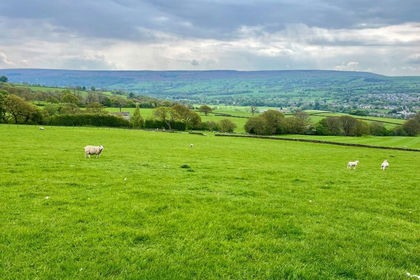
- Price
- Guide Price£400,000
- Size
- 33.5 acres
Added on 01/07/2026Farm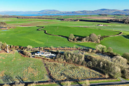
- Price
- Offers in Excess of£525,000
- Size
- 7.89 acres
Added on 29/01/2026Smallholding
- Price
- Offers in Excess of£595,000
- Size
- 16.61 acres
Nunland, Lochfoot, Dumfries, DG2 8PZ, Dumfries and Galloway, Dumfries and Galloway DG2 8PZ Scotland
Added on 29/01/2026Cottage