Rorkes Drift, Wheat Street, Brecon, Powys, Mid Wales, LD3
- Use Class
- Use Classes: E, Sui Generis
Key Features
- Town centre public house
- Contemporary, open plan trading area (60+)
- Independent, three bedroom owners accommodation (currently let as an Airbnb)
- Scope for lunchtime restaurant/café style operation
Description
The famous market town of Brecon (population 7,900) is synonymous with the National Park in the mountain range that bears its name. It is one of the UK's most iconic outward bound holiday locations and with the exposure of the same over the last thirty years the economy of this town and surrounding community have changed immeasurably.
The Rorkes Drift (formerly The Wheatsheaf) is one of the town's most central properties being a Georgian, Grade II listed building and dating back to the 17th Century.
The town is also the home of Dering Lines: home of the British Army Infantry Battle School, and the 160th Welsh Brigade. The Royal Welsh Regiment Museum is also located there and this facility attracts many visitors and houses a total of 18 Victoria Cross Medals, including some awarded at the famous South African Battle of Rorkes Drift during the Anglo Zulu War, from which the pub took its name. The event was immortalised in the 1964 film 'Zulu', directed by Cy Endfield.
Our clients acquired the business in 2010, prior to which it had been owned by a Pub Company. A major refurbishment programme was undertaken in 2014, and until 2020 and the Covid-19 pandemic the property was let to an independent tenant. Subsequently, it has been operated by our clients, although this has been on a wet sales only basis-they do not provide any food sales.
The property, which must be viewed to be appreciated, is briefly described as follows:-
TRADE AREAS
Located at ground floor is an OPEN PLAN BAR AREA which has a part wood sprung and part contemporary steel floor. There is modern seating throughout including leather bound, shaped, ribbed fixed seating providing curves and straight runs, together with loose, brushed steel effect chairs and high chairs to assorted low and poseur tables. BAR SERVERY which has mirrored panel frontage, mirrored display back fitting, and granite effect countertop. The room can cater for approximately 60 customers seated.
The CATERING KITCHEN is to the rear of the servery: whilst equipped, it is only utilised for the dispensing of snacks etc but could be utilised for dining trade, if desired. There is a PREPARATION/FREEZER ROOM adjacent. A set of well appointed LADIES' AND GENTLEMEN'S TOILETS.
BASEMENT BEER CELLAR.
OWNERS ACCOMMODATION/AIRBNB
Located at first floor, accessed by a private ground floor entrance, is extensive accommodation named 'Kookaburra Lodge'. It is not currently utilised by our clients but instead let as an Airbnb. The accommodation comprises THREE DOUBLE BEDROOMS, a KITCHEN/DINER, BATHROOM with suite of wash hand basin, WC, bath, and shower, and a DOMESTIC LOUNGE.
More details can be viewed on the Airbnb website: 58741
At SECOND FLOOR, accessed via a staircase, are THREE INTERCONNECTING ROOMS, currently utilised purely for storage but do have natural light.
Map Location
Property details
- Tenure
- Freehold
- Council Tax Band
- Ask Agent
- Date Posted
- 2026-01-29
Utilities & Restrictions
Utilities
- Electricity
- Ask Agent
- Water
- Ask Agent
- Heating
- Ask Agent
- Broadband
- Ask Agent
- Sewerage
- Ask Agent
Rights & Restrictions
- Public Rights of Way
- Ask Agent
- Private Rights of Way
- Ask Agent
- Listed Property
- Ask Agent
- Restrictions
- Ask Agent
Listed status, conservation areas and planning constraints for this location are in the full report.
Property Features
- Accessibility
- Ask Agent
- Parking
- Ask Agent
- Garden
- Ask Agent
Beyond the particulars: planning activity, flood history, heritage and ground risks, checked for this exact spot.
Connectivity
Broadband
Fastest speed available at this postcode
1.8 Gbps
Gigabit full fibre · available to 65% of premises
Suitable for
- 4K streaming on every screen
- Full-time home working
- Online gaming & big downloads
Mobile signal
Outdoor predictions; indoor signal depends on building materials.
Ofcom Connected Nations postcode-level predictions. Speeds and signal are modelled, not measured, and vary between addresses and providers.
Signal is the easy part. Planning activity, flood history and protected designations here are in the full report.
Nearest Schools
Primary
- Ysgol Golwg Pen Y Fan308 metres
- Pupils
- 300
- Type
- Infants & Juniors
- Language
- English medium school / provision
- Priory Church In Wales School568 metres
- Pupils
- 143
- Type
- Nursery, Infants & Juniors
- Language
- English medium school / provision
- Llanfaes C.P. School608 metres
- Pupils
- 193
- Type
- Nursery, Infants & Juniors
- Language
- English medium school / provision
- Ysgol Y Bannau0.7 miles
- Pupils
- 94
- Type
- Nursery, Infants & Juniors
- Language
- Welsh medium school / provision (including transitional)
- Llangors C.I.W. School5.5 miles
- Pupils
- 141
- Type
- Nursery, Infants & Juniors
- Language
- English medium school / provision
Secondary
- Brecon High School729 metres
- Pupils
- 557
- Type
- Secondary (ages 11-19)
- Language
- English medium school / provision
- Gwernyfed High School9.8 miles
- Pupils
- 505
- Type
- Secondary (ages 11-19)
- Language
- English medium school / provision
- Crickhowell High School12 miles
- Pupils
- 942
- Type
- Secondary (ages 11-19)
- Language
- English medium school / provision
- Pen-Y-Dre High School12 miles
- Pupils
- 893
- Type
- Secondary (ages 11-16)
- Language
- English medium school / provision
- Blessed Carlo Acutis Catholic School13 miles
- Pupils
- 989
- Type
- Middle (ages 3-16)
- Language
- English medium school / provision
Distances are straight-line from the advertised location. Source: the national school registers (DfE, Welsh Government, Scottish Government) and Ofsted.
Schools are just the start: sold prices nearby, planning activity and any flood history are in the full report.
Amenities
Supermarket
GP surgery
Pharmacy
Green space
Straight-line distances from the advertised location. Sources: NHS records, Geolytix supermarket locations, OS Open Greenspace and the national trails registers.
The area stacks up? Now check the location itself: planning nearby, protected designations and past flooding.
Getting Around
Nearest station
Nearest bus stop
Typical drive times
Straight-line distances from the advertised location; drive times are typical free-flow times over OpenStreetMap road data, so allow more at peak. Public transport locations from DfT NaPTAN.
Easy to reach matters. So do planning activity, flood history and ground risks: all in the full report.
Flood Risk
From Natural Resources Wales flood map open data, checked around the advertised map pin and allowing for the listed acreage where known. This summary comes from LandSale, the advertising platform, not from the listing agent, and is not part of the agent's particulars. Risk can vary across a single holding, so verify anything critical through your own searches before committing.
Rivers and the sea
Surface water
The detail behind these bandings
The full report pinpoints where this location sits on the flood maps, and runs the deeper checks that usually only surface after an offer.
- Exact flood zones & annual chances (included in the full report)
- Any recorded past flooding (included in the full report)
- Planning activity nearby (included in the full report)
- Heritage & conservation (included in the full report)
- Protected nature designations (included in the full report)
- Ground risks (included in the full report)
- Sold prices nearby (included in the full report)
£14.99 · one-off purchase
By LandSale, the platform. Not provided by the listing agent. Ready in about a minute.
Important notice: Information, maps and tags on this page are drawn from the advertising agent's marketing materials or generated automatically. LandSale has not verified them. Relying on these details is at your own risk, always carry out independent checks before committing to a purchase.
LandSale full disclaimer
Marketing information only - not formal particulars. The details on this website are provided for general guidance and do not constitute an offer or contract. Neither LandSale nor the advertising estate/land agent accepts responsibility for any inaccuracy.
1. Source of information
- Listing content: Core description, asking price, tenure, measurements, photographs and planning history originate from the marketing materials of the advertising estate or land agent. LandSale does not author this content and cannot guarantee its accuracy.
- Automated tags & categorisation: Property type, land-use class, acreage bands and similar labels may be applied by machine-learning models. They are intended as a helpful guide only and may not reflect the property's legal status or permitted use.
- Third-party & enriched data layers: Maps, boundary outlines, planning designations, soil reports, broadband coverage and other environmental or location-based insights are licensed from external suppliers. Such data are supplied “as is", may be incomplete or out of date and are subject to change without notice.
2. Verification required
Prospective purchasers must verify critical matters, including but not limited to planning permission, title boundaries, public rights of way, environmental constraints, acreage, services, access and VAT status, through their own inspections, specialist surveys, legal advisers and the selling agent before relying on the information or entering into any contract.
3. No warranty or liability
LandSale gives no warranty, express or implied, as to the accuracy, completeness or fitness for any particular purpose of the information displayed. LandSale shall not be liable for any loss, damage, cost or expense arising directly or indirectly from any use of or reliance on such information, save where liability may not be excluded by law.
4. Updates & feedback
If you believe any detail on this listing is inaccurate, please let us know. We will investigate and, where appropriate, update the listing or notify the agent.
© LandSale | Version 1.3 - August 2026
Listing agent
Sidney Phillips Limited, Wales
Shepherds Meadow, Eaton Bishop, HR2 9UA
Similar properties for sale
- Price
- Guide Price£275,000
Black Cock Inn, Llanfihangel Talyllyn, Brecon, Powys, LD3, Llangors, Powys LD3 Wales
Added on 29/01/2026Pub Added on 17/07/2026Pub
- Price
- £280,000
Cendle Inn, Beaufort Hill, Ebbw Vale, Gwent, Blaenau Gwent, NP23, Beaufort, Blaenau Gwent NP23 Wales
Added on 29/01/2026Pub
- Price
- £350,000
Rose & Crown, Rose And Crown, Broad Street, Hay-on-wye, Hereford, Powys, Hay, Powys HR3 Wales
Added on 17/07/2026Pub
- Price
- Guide Price£295,000
Added on 29/01/2026Pub Added on 29/01/2026Pub
- Price
- Guide Price£265,000
SOUTH WALES - WELL ESTABLISHED VILLAGE CENTRE PUBLIC HOUSE, Troed-y-rhiw, Merthyr Tydfil CF48 Wales
Added on 29/01/2026Pub
- Price
- £270,000
Added on 18/07/2026Pub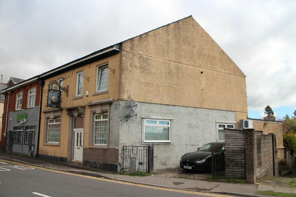
- Price
- £225,000
Added on 29/01/2026Pub
- Price
- Offers in Region of£350,000
- Size
- 1.5 acres
Land At Oakwood Close, Pen-Y-Fan Industrial Estate, Newport, NP11, Crumlin, Caerphilly NP11 Wales
Added on 04/02/2026Development Land