Land At Wreaks End, Broughton-In-Furness, Cumbria
- Land size
- 41.66 acres
Key Features
- Agricultural meadow and pasture land extending in all to circa 41.66 acres.
- Available for sale in two lots or as a whole.
- Mains and natural water supplies.
- Lot 2 benefits from direct roadside access off A595.
- Located within the Lake District National Park [UNESCO World Heritage Site].
- Of interest to local land and property owners, farmers, investors and those looking for environmental opportunities.
Description
An excellent opportunity to purchase sound pasture and meadow land, all within a ringfence.
Located within the Lake District National Park [UNESCO World Heritage Site]. Offered for sale by Private Treaty in two lots or as a whole.
Lot 1: 15.39 acres (6.23 ha) Lot 2: 26.27 acres (10.63 ha)
Extending in all to approximately 41.66 acres (16.86 hectares)
LOT 1
Guide Price - £170,000
Extending to 15.39 acres (6.23 hectares)
Coloured red on the Sale Plan
Lot 1 comprises two enclosures of sound meadowland. The land benefits from a right of way at all times and for all purposes through the converted farmstead, delineated on the sale plan dashed pink.
The land is serviced by both mains and natural water supplies. The mains supply is to a water trough located within parcel 8355, the approximate location of which is marked ‘WT’ on the sale plan.
Boundaries comprise predominantly mature hedgerows and post/ wire fences, with some lengths of dry-stone wall to the adjacent residential properties. All the boundaries are deemed stockproof.
Lot 1 benefits from useful sheep handling facilities in the southwest corner of parcel 8355, adjacent to the entranceway. The open-fronted building and associated concrete surround, to the direct south of the sheep pens are excluded from this sale. The vendor will retain a right to access this building from the converted farmstead, following completion of sale.
LOT 2
Guide Price - £230,000
Extending to 26.27 acres (10.63 hectares)
Coloured blue on the Sale Plan
Two enclosures of pasture/ meadow land. Lot 2 benefits from direct roadside access from the A595, via a gateway in parcel 6366’s southwestern corner (marked ‘A’ on the sale plan). Should Lots 1 & 2 sell separately, Lot 2 will benefit from a right of access through the converted farmstead and a across a small section of Lot 1 – delineated on the plan dashed pink and yellow.
The land is serviced by both mains and natural water supplies. A water trough, supplied by a mains connection, is located within the centre of parcel 6366, as shown marked ‘WT’ on the sale plan.
Boundaries comprise primarily post/ wire fences, all of which are deemed stockproof.
Directions
Heading northwest along the A5092 from Greenodd roundabout, follow the road for approximately 7.6 miles, passing by the villages of Lowick Green, Gawthwaite and Grizebeck. As you approach Broughton-in-Furness and where the road straightens (Wreaks Causeway), the land will be located on the right hand side, directly adjacent to the public highway and marked by the selling agent’s board(s).
Location
The land is located approximately 1.15 miles east of the popular market town of Broughton in Furness, 2.6 miles north of Kirkby in Furness and 5.8 miles southwest of Torver. The property’s situation provides excellent northerly views toward the Lake District’s Southern Fells.
Grid Reference: SD
What3Words: digested.vast.moves
Services
Tenure
Freehold. Vacant possession upon completion.
Services
The land benefits from both natural and mains water supplies. At present the mains supply to Lots 1 & 2 operates under the same system. Should Lots 1 & 2 sell separately, sub meters to each trough will have to be installed. The associated costs for this installation will be split 50/50 between the two purchasers.
Access
Lot 1 benefits from a right of access from the A595 and through the converted farmstead along the route shown dashed pink on the attached sale plan.
Lot 2 benefits from direct roadside access off the A595, via a gateway in parcel 6366’s southwestern corner marked ‘A’ on the sale plan. Lot 2 also benefits from a right of access through the converted farmstead and across a small section of Lot 1’s entranceway – shown dashed yellow on the sale plan.
Wayleaves and Easements
The sale is subject to all the existing rights of way, drainage, light, air support and other easements and quasi-easements and outgoings whether mentioned in these particulars or not.
Boundaries
The ownership and maintenance responsibilities of the boundaries are indicated with the “T” marks on the sale plan. Where no “T” marks are shown, the responsibilities are unknown.
Environmental Stewardship Schemes
The land is currently entered into a ELS agreement.
Purchasers will be obliged to take over and comply with the agreement requirements, join a new SFI scheme which prevents any reclaims being made or reimburse the vendor for any penalties. The respective purchasers will be required to complete the relevant Land Transfer and Amendment Form (LTA) for their respective purchases. Assistance will be available for this, but a small fee would be charged on an hourly basis.
Local Planning Authority
Lake District National Park – .
Sporting Rights
Included insofar as we are aware.
Mineral Rights
Included insofar as we are aware, with the exception of those associated with parcel 9651.
Sale Plan
The Sale Plan has been prepared by the Selling Agent for the convenience of the prospective purchasers. It is deemed to be correct, but any error, omission or misstatement shall not affect the sale. Purchasers must satisfy themselves as to accuracy.
Method of Sale
The property is to be offered for sale as a Whole or in Two Lots by Private Treaty.
Viewing
The land can be inspected at any reasonable time provided that a copy of these particulars are in possession. Please ensure that gates are firmly closed and do not take dogs. We kindly ask that when viewing, prospective purchasers are considerate when parking in the area - as to not cause disturbance to the surrounding residential properties.
Map Location
Property details
- Tenure
- Freehold
- Council Tax Band
- TBC
- Date Posted
- 2026-01-29
Market Value Analysis
Compared with 49 Farmland & Pasture listings in North West England (25+ acres).
Utilities & Restrictions
Utilities
- Electricity
- Ask Agent
- Water
- Ask Agent
- Heating
- Ask Agent
- Broadband
- Ask Agent
- Sewerage
- Ask Agent
Rights & Restrictions
- Public Rights of Way
- Ask Agent
- Private Rights of Way
- Ask Agent
- Listed Property
- Ask Agent
- Restrictions
- Ask Agent
Property Features
- Accessibility
- Ask Agent
- Parking
- Parking Available
- Garden
- Ask Agent
Important notice: Information, maps and tags on this page are supplied by the advertising agent or generated automatically. LandSale has not verified them. Relying on these details is at your own risk, always carry out independent checks before committing to a purchase.
LandSale full disclaimer
Marketing information only - not formal particulars. The details on this website are provided for general guidance and do not constitute an offer or contract. Neither LandSale nor the advertising estate/land agent accepts responsibility for any inaccuracy.
1. Source of information
- Agent-supplied content: Core description, asking price, tenure, measurements, photographs and planning history are uploaded by the appointed agent, who remains solely responsible for their accuracy.
- Automated tags & categorisation: Property type, land-use class, acreage bands and similar labels may be applied by machine-learning models. They are intended as a helpful guide only and may not reflect the property's legal status or permitted use.
- Third-party & enriched data layers: Maps, boundary outlines, planning designations, soil reports, broadband coverage and other environmental or location-based insights are licensed from external suppliers. Such data are supplied “as is", may be incomplete or out of date and are subject to change without notice.
2. Verification required
Prospective purchasers must verify critical matters, including but not limited to planning permission, title boundaries, public rights of way, environmental constraints, acreage, services, access and VAT status, through their own inspections, specialist surveys, legal advisers and the selling agent before relying on the information or entering into any contract.
3. No warranty or liability
LandSale gives no warranty, express or implied, as to the accuracy, completeness or fitness for any particular purpose of the information displayed. LandSale shall not be liable for any loss, damage, cost or expense arising directly or indirectly from any use of or reliance on such information, save where liability may not be excluded by law.
4. Updates & feedback
If you believe any detail on this listing is inaccurate, please let us know. We will investigate and, where appropriate, update the listing or notify the agent.
© LandSale | Version 1.2 - January 2026
Listing agent
H&H Land & Estates, Penrith
1a St. Andrews View Penrith CA11 7YF
Similar properties for sale

- Price
- Guide Price£400,000
- Size
- 63.96 acres
Added on 29/01/2026Timberland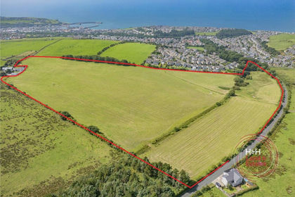
- Price
- Guide Price£500,000
- Size
- 22.55 acres
Land At Harras Moor, Whitehaven, Whitehaven, Cumberland CA28 6JQ England
Added on 29/01/2026Grazing Land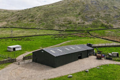
- Price
- Guide Price£430,000
- Size
- 29.5 acres
Lot 3 - Brockholes Farm, Tebay, CA10 3XT, Tebay, Westmorland and Furness CA10 3XT England
Added on 09/06/2026Farmland
- Price
- Guide Price£330,000
- Size
- 56.83 acres
Lot 2 - Brockholes Farm, Tebay, CA10 3XT, Tebay, Westmorland and Furness CA10 3XS England
Added on 09/06/2026Farmland
- Price
- Guide Price£430,000
- Size
- 47.76 acres
Wennington, Lancaster, North Yorkshire, Wennington, Lancashire LA2 8NY England
Added on 07/07/2026Grazing Land
- Price
- £460,000
- Size
- 51.44 acres
New Lane, Eagland Hill, Preston, Lancashire, Pilling, Lancashire PR3 6BA England
Added on 11/06/2026Arable Land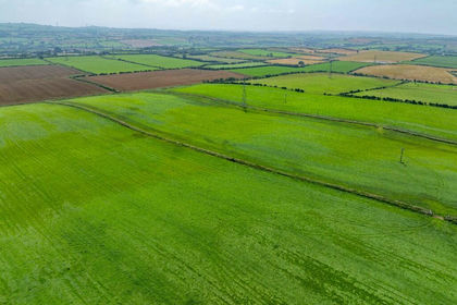
- Price
- Guide Price£415,000
- Size
- 34.45 acres
Added on 29/01/2026Agricultural Land