School Lane, Castle Combe, Wiltshire, SN14
- Land size
- 3.86 acres
- Bedrooms
- 4
- Bathrooms
- 3
Key Features
- Beautiful Grade II Listed House
- Hugely desirable village location.
- The gardens are sheltered and utterly private.
- Summer House
- Beautifully landscaped gardens
- Parking
- Paddock
- In all approximately 3.85 acres
Description
An incredibly attractive Grade II Listed house in the hugely desirable village of Castle Combe with 3.86 acres
ABOUT THIS HOUSE
Combe House is a home that embodies the very spirit of the Cotswolds. Handsome and steeped in history, the property is built from the warm, honey-coloured stone that has made the village so celebrated, its façade softened by time and framed by the countryside that surround it.
Combe House sits along School Lane, a part of Castle Combe rich in architectural legacy. The lane itself is anchored by this former village school, built in 1826 in the C16 style and still standing today with its mullioned windows, stone-tiled roof, and attached gatepiers once marking the entrance to the Manor House Estate.
The presence of such a generously scaled school in this small village speaks of the importance of education and community in the early 19th century, and properties like Combe House would have watched that history unfold just beyond their threshold. Nestled within this tapestry of stone and story, Combe House carries with it the quiet dignity of place — a home shaped by centuries of village life, surrounded by buildings that tell the tale of Castle Combe’s enduring heritage.
Inside, the house unfolds with a sense of quiet grandeur. Generous reception rooms invite gatherings beside fires, while mullioned windows usher in soft light and views over the gardens and terraces. Character is woven through every corner with exposed beams, stone fireplaces, and gentle quirks of age that speak of centuries of life well lived.
The kitchen is the natural heart of the house, its welcoming scale perfect for both convivial suppers and simple family breakfasts. Upstairs, the bedrooms are restful and full of charm, each offering glimpses of the rooftops, trees and countryside that make this part of Wiltshire so enchanting.
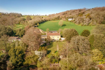
Outside, the gardens are as much about atmosphere as design — sheltered, green, and utterly private. Here, stone walls enclose lawns and borders, and a terrace offers a perfect vantage point to pause and take in the stillness of this extraordinary village.
ABOUT THIS AREA
In the gentle folds of the Cotswolds, Castle Combe is a village that seems to have slipped quietly out of another century. Often described as the prettiest village in England, it is a place of storybook beauty, where crooked lanes wind past cottages built from the soft, honey-coloured stone that defines this landscape.
At the centre of the village stands the medieval Market Cross, a gathering point for centuries of villagers, and just beyond it rises St Andrew’s Church, its 13th-century tower sheltering a remarkable treasure: a faceless clock, still faithfully keeping time after more than 600 years.
Life here has an unhurried charm. There are two welcoming pubs, each with fires that burn through winter, and a distinguished country hotel with manicured grounds and its own golf course, offering a taste of quiet grandeur. Yet Castle Combe is no sleepy backwater — on the edge of the village the motor circuit hums with energy, where drivers trade winding lanes for the exhilaration of the track.
The nearby village of Yatton Keynell has a primary school, doctors surgery, driving range and public house. A little further afield is Bath, which is renowned for its famous Roman-built baths, and a UNESCO World Heritage Site. Bath has a huge array of handsome Georgian buildings and an enormous collection of cultural and culinary experiences.
Wiltshire is recognized for its excellent selection of private and state schools, all being within easy driving distance. Local private schools include Stonar, Hayw00d Prep, Kingswood, Monkton Combe, Downside, Prior Park, Royal High School Bath, St. Marys Calne, Westonbirt, Marlborough College, Dauntsey’s, and Cheltenham schools. Additionally, there are a number of local state schools including Sheldon, Hardenhuish and Malmesbury.
The area is well-connected to some of London’s fastest rail-links with Chippenham Station only 6.3 miles away and is well positioned for access to the M4, both junctions 17 & 18 only a short drive away.
TOWNS AND STATIONS
Yatton Keynell 1.7 miles
Chippenham 5.5 miles
Corsham 6.2
Tetbury 13 miles
Bath 13.0 miles
Bristol 19.0 miles
Swindon 22.0 miles
Chippenham Station 5.8 miles
London Paddington from 62 mins
Map Location
Property details
- Tenure
- Freehold
- Council Tax Band
- TBC
- Date Posted
- 2026-01-29
Market Value Analysis
Compared with 5 Historic listings in South West England (1+ acres).
Energy Performance Certificate
Energy Efficiency Rating
Based on UK Energy Performance Certificate standards (EU Directive 2002/91/EC)
Running costs are one side. Planning activity, flood history and ground risks for this location are in the full report.
Utilities & Restrictions
Utilities
- Electricity
- Ask Agent
- Water
- Ask Agent
- Heating
- Ask Agent
- Broadband
- Ask Agent
- Sewerage
- Ask Agent
Rights & Restrictions
- Public Rights of Way
- Ask Agent
- Private Rights of Way
- Ask Agent
- Listed Property
- Ask Agent
- Restrictions
- Ask Agent
Listed status, conservation areas and planning constraints for this location are in the full report.
Property Features
- Accessibility
- Ask Agent
- Parking
- Parking Available
- Garden
- Garden
Beyond the particulars: planning activity, flood history, heritage and ground risks, checked for this exact spot.
Connectivity
Broadband
Fastest speed available at this postcode
80 Mbps
Superfast
Suitable for
- HD streaming
- Video calls
- Web & social
Mobile signal
Predicted 4G and 5G signal; indoor signal depends on building materials.
Ofcom Connected Nations postcode-level predictions. Speeds and signal are modelled, not measured, and vary between addresses and providers.
Signal is the easy part. Planning activity, flood history and protected designations here are in the full report.
Nearest Schools
Primary
- By Brook Valley CofE Primary School1.7 milesOfsted: Good *
- Ages
- 4 to 11
- Pupils
- 179
- Type
- Academy converter
- Faith
- Church of England
- Trinity Church of England Primary School2.8 milesOfsted: Good *
- Ages
- 4 to 11
- Pupils
- 99
- Type
- Voluntary controlled school
- Faith
- Church of England
- Kington St Michael Church of England Primary School3.5 milesOfsted: Good *
- Ages
- 5 to 11
- Pupils
- 127
- Type
- Voluntary controlled school
- Faith
- Church of England
- Colerne CofE Primary School4.1 milesNo Ofsted rating
- Ages
- 4 to 11
- Pupils
- 212
- Type
- Voluntary controlled school
- Faith
- Church of England
- Luckington Community School4.1 milesNo Ofsted rating
- Ages
- 4 to 11
- Pupils
- 43
- Type
- Community school
Secondary
- Hardenhuish School4.4 milesNo Ofsted rating
- Ages
- 11 to 18
- Pupils
- 1,519
- Type
- Academy converter
- Sheldon School4.4 milesOfsted: Good
- Ages
- 11 to 18
- Pupils
- 1,467
- Type
- Academy converter
- The Corsham School4.8 milesOfsted: Good
- Ages
- 11 to 18
- Pupils
- 1,427
- Type
- Academy converter
- Abbeyfield School6.5 milesOfsted: Good
- Ages
- 11 to 19
- Pupils
- 902
- Type
- Academy converter
- Chipping Sodbury School7.8 milesOfsted: Good
- Ages
- 11 to 18
- Pupils
- 775
- Type
- Academy converter
* Latest graded judgement covers quality of education only; no overall grade was issued under the 2024-25 inspection framework.
Distances are straight-line from the advertised location. Source: the national school registers (DfE, Welsh Government, Scottish Government) and Ofsted.
Schools are just the start: sold prices nearby, planning activity and any flood history are in the full report.
Amenities
Supermarket
GP surgery
Pharmacy
Hospital
Green space
Straight-line distances from the advertised location. Sources: NHS records, Geolytix supermarket locations, OS Open Greenspace and the national trails registers.
The area stacks up? Now check the location itself: planning nearby, protected designations and past flooding.
Getting Around
Nearest station
Nearest bus stop
Typical drive times
Straight-line distances from the advertised location; drive times are typical free-flow times over OpenStreetMap road data, so allow more at peak. Public transport locations from DfT NaPTAN.
Easy to reach matters. So do planning activity, flood history and ground risks: all in the full report.
Flood Risk
Environment Agency open data, checked around the advertised map pin for the listed acreage. Long-term risk counts flood defences; the planning map's flood zones do not. Provided by LandSale, not the listing agent, and not part of the agent's particulars. Risk varies across a holding, so verify before committing.
Rivers and the sea
Planning map: Flood Zone 1.
Surface water
Not at the pin: mapped about 40 metres away.
These bandings are the summary. Where this location sits on the flood maps, plus planning activity, heritage and ground risks, is in the full report.
Important notice: Information, maps and tags on this page are drawn from the advertising agent's marketing materials or generated automatically. LandSale has not verified them. Relying on these details is at your own risk, always carry out independent checks before committing to a purchase.
LandSale full disclaimer
Marketing information only - not formal particulars. The details on this website are provided for general guidance and do not constitute an offer or contract. Neither LandSale nor the advertising estate/land agent accepts responsibility for any inaccuracy.
1. Source of information
- Listing content: Core description, asking price, tenure, measurements, photographs and planning history originate from the marketing materials of the advertising estate or land agent. LandSale does not author this content and cannot guarantee its accuracy.
- Automated tags & categorisation: Property type, land-use class, acreage bands and similar labels may be applied by machine-learning models. They are intended as a helpful guide only and may not reflect the property's legal status or permitted use.
- Third-party & enriched data layers: Maps, boundary outlines, planning designations, soil reports, broadband coverage and other environmental or location-based insights are licensed from external suppliers. Such data are supplied “as is", may be incomplete or out of date and are subject to change without notice.
2. Verification required
Prospective purchasers must verify critical matters, including but not limited to planning permission, title boundaries, public rights of way, environmental constraints, acreage, services, access and VAT status, through their own inspections, specialist surveys, legal advisers and the selling agent before relying on the information or entering into any contract.
3. No warranty or liability
LandSale gives no warranty, express or implied, as to the accuracy, completeness or fitness for any particular purpose of the information displayed. LandSale shall not be liable for any loss, damage, cost or expense arising directly or indirectly from any use of or reliance on such information, save where liability may not be excluded by law.
4. Updates & feedback
If you believe any detail on this listing is inaccurate, please let us know. We will investigate and, where appropriate, update the listing or notify the agent.
© LandSale | Version 1.3 - August 2026
Listing agent
The Country House Department Limited, Southern EnglandThe Wooden Barn, Little Baldon Farm, Oxford, OX44 9PU
View agent profileSimilar properties for sale
- Price
- Guide Price£1,950,000
- Size
- 1.4 acres
Wraxall Hill, Wraxall, Bristol, Somerset, BS48, Wraxall and Failand, North Somerset BS48 England
Added on 18/04/2026Historic House
- Price
- £1,300,000
- Size
- 5.63 acres
Rogiet, Caldicot, Monmouthshire, NP26, Rogiet, Monmouthshire NP26 Wales
Added on 28/01/2026Development Land
- Price
- Guide Price£1,750,000
- Size
- 6 acres
Added on 15/04/2026Development Land
- Price
- Guide Price£1,750,000
- Size
- 2 acres
Added on 21/07/2026Development Land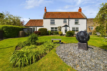
- Price
- £1,400,000
- Size
- 3 acres
Summer Lane, Banwell, North Somerset, BS29, Banwell, North Somerset BS29 England
Added on 29/01/2026Development Land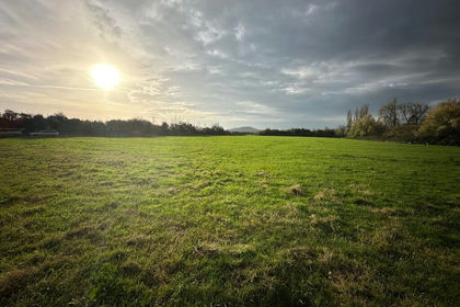
- Price
- Guide Price£1,750,000
- Size
- 6.21 acres
Land at Beavers Lodge Farm, Lympsham Road, BS24, Lympsham, Somerset BS24 England
Added on 29/01/2026Development Land