Bro Elfed, Cynwyl Elfed, SA33
- Land size
- 0.94 acres
Key Features
- An Exciting Opportunity to Acquire a Freehold Development Site
- In the Village of Cynwyl Elfed.
- With Outline Planning Consent for Four Detached Properties
Description
An exciting opportunity to acquire a freehold development site with outline planning consent for four detached properties in the village of Cynwyl Elfed.
The development site occupies a frontage position off the western flank of the A484 at Green Park, within the village of Cynwyl Elfed. It consists of a sloping rectangular shaped area of land, which accommodates a corrugated metal livestock shed off its northern perimeter with adjoining grazing fields. The southern side perimeter forms a point where a larger yard and outbuilding are present, also set several metres above the public carriageway, but screened from that road by extensive frontage trees and hedgerows. Vehicular passage to the small yard is made via an unmade access track, which runs parallel, but at an acute angle with the A484.
SITE AREA : 3826 SQ.M (.38 HA) GRID REF : SN
EPC Rating: E
Planning Consent
Planning Application No: W/36827 registered: 15/02/2018 for:
Proposal : VARIATION OF CONDITION 3 OF W/30896 TO ALLOW A PERIOD OF A FURTHER 3 YEARS TO SUBMIT APPROVAL OF RESERVED MATTERS
Location : LAND OPPOSITE, GREEN PARK, CYNWYL ELFED, CARMARTHEN, SA33 6TN
Carmarthenshire County Council HEREBY GRANT permission for development proposed by you in
accordance with the application and plans previously approved, and subject to the following
condition(s):-
Conditions
CONDITIONS
1 The permission now granted is an outline planning permission only, within the meaning of the Town and Country Planning (General Development Procedure) Order 1995.
2 Details of the access, appearance, landscaping, layout, and scale, (hereinafter called "the reserved matters") shall be submitted to and approved in writing by the local planning authority before any development begins and the development shall be carried out as approved.
3 Any application for approval of the reserved matters shall be made to the local planning authority not later than three years from the date of this permission.
4 The development shall begin either before the expiration of five years from the date of this permission or before the expiration of two years from the date of approval of the last of the reserved matters to be approved, whichever is the later.
Site Area & Location
Site marked in red on the location plan.
SITE AREA : 3826 SQ.M (.38 HA)
GRID REF : SN
what3words:- ///backpack.argued.marinated
Map Location
Property details
- Tenure
- Freehold
- Council Tax Band
- Ask Agent
- Date Posted
- 2026-01-29
Utilities & Restrictions
Utilities
- Electricity
- Ask Agent
- Water
- Ask Agent
- Heating
- Ask Agent
- Broadband
- Ask Agent
- Sewerage
- Ask Agent
Rights & Restrictions
- Public Rights of Way
- Ask Agent
- Private Rights of Way
- Ask Agent
- Listed Property
- Ask Agent
- Restrictions
- Ask Agent
Property Features
- Accessibility
- Ask Agent
- Parking
- Ask Agent
- Garden
- Garden
Important notice: Information, maps and tags on this page are supplied by the advertising agent or generated automatically. LandSale has not verified them. Relying on these details is at your own risk, always carry out independent checks before committing to a purchase.
LandSale full disclaimer
Marketing information only - not formal particulars. The details on this website are provided for general guidance and do not constitute an offer or contract. Neither LandSale nor the advertising estate/land agent accepts responsibility for any inaccuracy.
1. Source of information
- Agent-supplied content: Core description, asking price, tenure, measurements, photographs and planning history are uploaded by the appointed agent, who remains solely responsible for their accuracy.
- Automated tags & categorisation: Property type, land-use class, acreage bands and similar labels may be applied by machine-learning models. They are intended as a helpful guide only and may not reflect the property's legal status or permitted use.
- Third-party & enriched data layers: Maps, boundary outlines, planning designations, soil reports, broadband coverage and other environmental or location-based insights are licensed from external suppliers. Such data are supplied “as is", may be incomplete or out of date and are subject to change without notice.
2. Verification required
Prospective purchasers must verify critical matters, including but not limited to planning permission, title boundaries, public rights of way, environmental constraints, acreage, services, access and VAT status, through their own inspections, specialist surveys, legal advisers and the selling agent before relying on the information or entering into any contract.
3. No warranty or liability
LandSale gives no warranty, express or implied, as to the accuracy, completeness or fitness for any particular purpose of the information displayed. LandSale shall not be liable for any loss, damage, cost or expense arising directly or indirectly from any use of or reliance on such information, save where liability may not be excluded by law.
4. Updates & feedback
If you believe any detail on this listing is inaccurate, please let us know. We will investigate and, where appropriate, update the listing or notify the agent.
© LandSale | Version 1.2 - January 2026
Listing agent
JJ Morris, Cardigan
5 High Street, Cardigan, SA43 1HJ
Similar properties for sale

- Price
- Offers in Region of£125,000
- Size
- 1 acres
Cynwyl Elfed, Carmarthen, SA33 6TN, Cynwyl Elfed, Carmarthenshire SA33 6TN Wales
Added on 29/01/2026Development Land Added on 29/01/2026Development Land
- Price
- £185,000
Llangludwen, Whitland, Carmarthenshire, SA34, Llanboidy, Carmarthenshire SA34 0XP Wales
Added on 29/01/2026Building Plot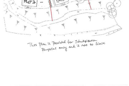
- Price
- Offers in Excess of£130,000
- Size
- 0.99 acres
Cwmfelin Boeth, Whitland, Henllanfallteg, Carmarthenshire SA34 0RR Wales
Added on 27/06/2026Building Plot Added on 29/01/2026Development Land
 Added on 29/01/2026Building Plot
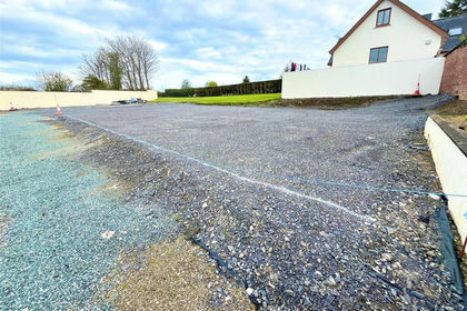
- Price
- Offers in Region of£150,000
Hill Lane, Kilgetty, Pembrokeshire, SA68, East Williamston, Pembrokeshire SA68 0QT Wales
Added on 29/01/2026Building Plot
- Price
- Offers in Region of£125,000
Opposite West Holloway House, Penally, SA70, Penally, Pembrokeshire SA70 7NR Wales
Added on 29/01/2026Building Plot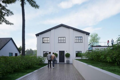
- Price
- Guide Price£146,000
Added on 10/07/2026Building Plot Added on 18/06/2026Development Land