Scorrier Road, Redruth - Development site for nine units
- Land size
- 0.5 acres
Key Features
- Brownfield development site
- Nine units in total
- One detached unit
- Pair of semi-detached units
- Two terraces of three units
- Community Infrastructure Levy discharged
- Potential to retain and refurbish existing house
- Located on the Truro side of Redruth
- All open market units
- No onward chain
Description
An exciting opportunity to acquire a development site for nine dwellings with associated amenity space.
The proposed scheme is for two terraces of three properties, a pair of semi-detached properties and a detached property.
This is a brown field site of approximately half an acre and will require the demolition of an existing house, alternatively (subject to any required consents) the house could be retained and refurbished with a smaller scheme being applied for.
The development proposed requires a community infrastructure levy (CIL) which has been discharged by our vendor.
Full details of the proposed development can be found on Cornwall Council Planning Portal reference PA21/10689.
Situated on the Truro side of Redruth, local shopping facilities are available nearby at Mount Ambrose and there is schooling for younger children at Treleigh with Redruth Senior School being within a mile.
The town of Redruth offers an eclectic mix of both local and national shopping outlets, there is a mainline Railway Station which connects with London Paddington and the north of England and the A30 trunk road can be accessed within three quarters of a mile.
Truro, which is the administrative and cultural centre of Cornwall is within nine miles and the south coast university town of Falmouth is within eleven miles.
AGENT'S NOTE
Please be aware that the property on the site has mains water, mains gas and mains electric connected and there is private drainage at present using a septic tank. All mains services are believed to be in the road outside although this will need to be checked by any potential purchaser.
DIRECTIONS
From Avers roundabout in Redruth, take the A3047 heading towards Scorrier and after passing the Treliegh Arms onyour right hand side carry on along the road, crossing over the railway line and at the next mini-roundabout take the first exit left and the development site will be identified on the right hand side by our 'For Sale' board. If using What3words:- insect.rudder.clinking
Map Location
Property details
- Tenure
- Freehold
- Council Tax Band
- TBC
- Date Posted
- 2026-01-29
Utilities & Restrictions
Utilities
- Electricity
- Ask Agent
- Water
- Ask Agent
- Heating
- Ask Agent
- Broadband
- Ask Agent
- Sewerage
- Ask Agent
Rights & Restrictions
- Public Rights of Way
- Ask Agent
- Private Rights of Way
- Ask Agent
- Listed Property
- Ask Agent
- Restrictions
- Ask Agent
Property Features
- Accessibility
- Ask Agent
- Parking
- Ask Agent
- Garden
- Ask Agent
Important notice: Information, maps and tags on this page are supplied by the advertising agent or generated automatically. LandSale has not verified them. Relying on these details is at your own risk, always carry out independent checks before committing to a purchase.
LandSale full disclaimer
Marketing information only - not formal particulars. The details on this website are provided for general guidance and do not constitute an offer or contract. Neither LandSale nor the advertising estate/land agent accepts responsibility for any inaccuracy.
1. Source of information
- Agent-supplied content: Core description, asking price, tenure, measurements, photographs and planning history are uploaded by the appointed agent, who remains solely responsible for their accuracy.
- Automated tags & categorisation: Property type, land-use class, acreage bands and similar labels may be applied by machine-learning models. They are intended as a helpful guide only and may not reflect the property's legal status or permitted use.
- Third-party & enriched data layers: Maps, boundary outlines, planning designations, soil reports, broadband coverage and other environmental or location-based insights are licensed from external suppliers. Such data are supplied “as is", may be incomplete or out of date and are subject to change without notice.
2. Verification required
Prospective purchasers must verify critical matters, including but not limited to planning permission, title boundaries, public rights of way, environmental constraints, acreage, services, access and VAT status, through their own inspections, specialist surveys, legal advisers and the selling agent before relying on the information or entering into any contract.
3. No warranty or liability
LandSale gives no warranty, express or implied, as to the accuracy, completeness or fitness for any particular purpose of the information displayed. LandSale shall not be liable for any loss, damage, cost or expense arising directly or indirectly from any use of or reliance on such information, save where liability may not be excluded by law.
4. Updates & feedback
If you believe any detail on this listing is inaccurate, please let us know. We will investigate and, where appropriate, update the listing or notify the agent.
© LandSale | Version 1.2 - January 2026
Listing agent
MAP Estate Agents, Barncoose
Gateway Business Centre, Wilson Way, Barncoose, Illogan Highway, TR15 3RQ
Contact MAP Estate Agents, Barncoose
Gateway Business Centre, Wilson Way, Barncoose, Illogan Highway, TR15 3RQ
View agent profileSimilar properties for sale

- Price
- £600,000
- Size
- 1.1 acres
Treleigh, Redruth - Detached Cottage With Glamping Site, Redruth, Cornwall TR16 4BE England
Added on 17/02/2026House with Land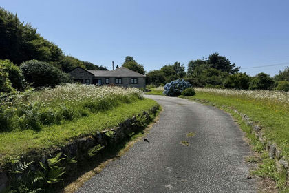
- Price
- Guide Price£750,000
- Size
- 3 acres
Added on 24/06/2026House with Land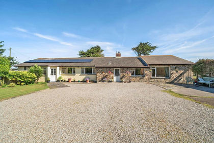
- Price
- £675,000
- Size
- 1.5 acres
Wheal Rose, Scorrier, Cornwall, St. Agnes, Cornwall TR16 5DR England
Added on 11/07/2026House with Land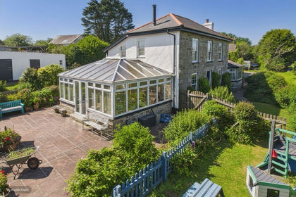
- Price
- £775,000
- Size
- 3.3 acres
Added on 09/06/2026House with Land
- Price
- Guide Price£750,000
- Size
- 4 acres
Lower Goongumpas Lane, Crofthandy, St Day, Cornwall, Gwennap, Cornwall TR16 5JL England
Added on 28/01/2026Cottage
- Price
- £775,000
- Size
- 2.5 acres
Added on 29/01/2026Cottage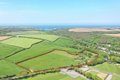
- Price
- Guide Price£690,000
- Size
- 6.7 acres
Added on 14/05/2026House with Land
- Price
- £700,000
- Size
- 1.5 acres
South Carn Brea, Carnkie, Redruth, Cornwall, TR16, Carn Brea, Cornwall TR16 6RX England
Added on 04/06/2026House with Land
- Price
- £500,000
- Size
- 5 acres
Higher Tregajorran, Carn Brea, Redruth, Cornwall, TR15, Carn Brea, Cornwall TR15 3YX England
Added on 05/03/2026Cottage
- Price
- Guide Price£799,950
- Size
- 7.4 acres
Added on 29/01/2026Farmhouse