Main Street, Welney
Key Features
- Unique development opportunity
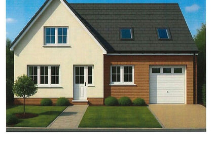
- Planning permission for 4no. Dwellings
- Outstanding riverside position
- Views over river and Welney Wash
- Stunning location
- Potential for other schemes such a single development
Description
Description
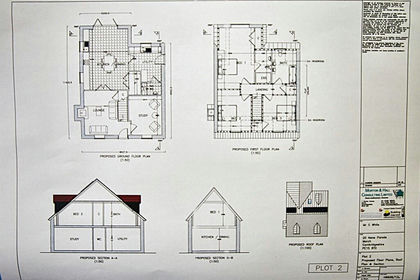
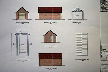
Land suitable for residential planning permission. The site has benefited from planning permission, detailed below, for residential development for 4 dwellings and may also be suitable for a single dwelling or alternative residential scheme, subject to a new planning application and the necessary consents being granted.
Location
Welney is a village located in the county of Norfolk, England. The village is situated on the A1101 road, which runs from Bury St Edmunds to Long Sutton. The village has a population of around 500 and is serviced by an excellent public house, The Lamb and Flag. The nearest train station to Welney is Littleport station, which is located approximately 7.6 miles (12 km) away with direct trains to Ely, Cambridge and London.
Welney Wash is an area of wildlife conservation located in the village of Welney, Norfolk, England. The area is home to a nature reserve called WWT Welney, which is managed by the Wildfowl and Wetlands Trust. The reserve is open to visitors throughout the year, except on Christmas day, and offers a beautiful wetland reserve and eco-friendly visitor center. The reserve is home to a variety of birds, including breeding birds and chicks in spring, dragonflies, butterflies, and wildflowers in summer, and thousands of whooper and Bewick's swans in winter, the largest gathering in the UK. Further information on the website wwt.org.uk
Planning Permission
Outline planning permission was granted by Borough Council of King's Lynn and West Norfolk in October 2023 under reference 23/00179/O Outline application, Residential development (4 dwellings) at the Former Three Tuns Public House, Land North of Welney Parish Hall And East of Old Bedford Row Bedford Bank, Welney, Norfolk. Details of the application can be inspected online via the Borough Council of King's Lynn and West Norfolk planning portal searching the reference number quoted above. Some copies of associated planning documents are held with the agent.
Services & Other Information
The site is subject to a S106 agreement, a copy is help by the agent.
The agent is advised CIL (Community infrastructure levy) is payable.
The buyer will assume responsibility of S106 and CIL, along with installation of services, access improvements.
The agent understands services are located nearby but, the agent is not aware of any services currently available on site.
Access roadway will be retained by the vendor with rights for services and rights to improve granted.
Viewing
The land may be viewed, in daylight hours, with a copy of these particulars in hand. Please note the land is currently overgrown and inspection in entirety may not be possible.
Health & Safety
Viewers should be careful and vigilant whilst on the property. Neither the Seller nor the Selling Agents are responsible for the safety of those viewing the property and accordingly those viewing the property do so at their own risk
Pland, Areas & Schedules
These have been prepared as carefully as possible and are based on the planning application, Ordnance Survey scale plans and HM Land Registry. All plans are published here are for identification and indicative purposes only and are believed to be correct however in no way should be relied upon.
Wayleaves, Easements & Rights of Way
The site is sold subject to and with the benefit of all existing rights, including rights of way, whether public or private, light, support, drainage, water and electricity supplies and other rights, easements, quasi-easements and all wayleaves whether referred to or not in these particulars.
Disputes
Should any dispute arise as to the boundaries or any point arising in these Particulars, schedule, plan or interpretation of any of them the question shall be referred to the arbitration of the Selling Agents, whose decision acting as expert shall be final. The Buyer shall be deemed to have full knowledge of all boundaries and neither the Seller nor the Selling Agents will be responsible for defining the boundaries or the ownership thereof.
Anti-Money Laundering
In accordance with the most recent Anti-Money Laundering legislation, a Buyer will be required to provide proof of identity and address to the Sellers' Agents once an offer is submitted and prior to Solicitors being instructed.
Map Location
Property details
- Tenure
- Freehold
- Council Tax Band
- Ask Agent
- Date Posted
- 2026-01-29
Price history
| Date | Change | Price |
|---|---|---|
| 9 Sep 2026 | Reduced 40% (−£80,000) | £120,000 |
| Until 9 Sep 2026 | Asking price | £200,000 |
Utilities & Restrictions
Utilities
- Electricity
- Ask Agent
- Water
- Ask Agent
- Heating
- Ask Agent
- Broadband
- Ask Agent
- Sewerage
- Ask Agent
Rights & Restrictions
- Public Rights of Way
- Ask Agent
- Private Rights of Way
- Ask Agent
- Listed Property
- Ask Agent
- Restrictions
- Ask Agent
Listed status, conservation areas and planning constraints for this location are in the full report.
Property Features
- Accessibility
- Ask Agent
- Parking
- Ask Agent
- Garden
- Ask Agent
Beyond the particulars: planning activity, flood history, heritage and ground risks, checked for this exact spot.
Connectivity
Broadband
Fastest speed available at this postcode
80 Mbps
Superfast
Suitable for
- HD streaming
- Video calls
- Web & social
Mobile signal
Outdoor predictions; indoor signal depends on building materials.
Ofcom Connected Nations postcode-level predictions. Speeds and signal are modelled, not measured, and vary between addresses and providers.
Signal is the easy part. Planning activity, flood history and protected designations here are in the full report.
Nearest Schools
Primary
- Townley Primary School2.8 milesOfsted: Good
- Ages
- 2 to 11
- Pupils
- 102
- Type
- Community school
- Manea Community Primary School3.9 milesOfsted: Good
- Ages
- 4 to 11
- Pupils
- 194
- Type
- Community school
- Littleport Community Primary School4.8 milesOfsted: Good *
- Ages
- 4 to 11
- Pupils
- 406
- Type
- Community school
- Millfield Primary School5.3 milesNo Ofsted rating
- Ages
- 3 to 11
- Pupils
- 416
- Type
- Academy converter
- Upwell Academy5.3 milesOfsted report card · May 2026
- Ages
- 4 to 11
- Pupils
- 180
- Type
- Academy sponsor led
Secondary
- Vista Academy Littleport4.5 milesOfsted report card · Nov 2025
- Ages
- 11 to 16
- Pupils
- 547
- Type
- Academy sponsor led
- Neale-Wade Academy6.9 milesOfsted report card · Jan 2026
- Ages
- 11 to 18
- Pupils
- 1,130
- Type
- Academy sponsor led
- Ely College8 milesNo Ofsted rating
- Ages
- 11 to 18
- Pupils
- 1,635
- Type
- Academy converter
- Downham Market Academy8.2 milesOfsted: Good
- Ages
- 11 to 18
- Pupils
- 1,329
- Type
- Academy sponsor led
- Witchford Village College9.2 milesNo Ofsted rating
- Ages
- 11 to 16
- Pupils
- 804
- Type
- Academy converter
* Latest graded judgement covers quality of education only; no overall grade was issued under the 2024-25 inspection framework.
Distances are straight-line from the advertised location. Source: the national school registers (DfE, Welsh Government, Scottish Government) and Ofsted.
Schools are just the start: sold prices nearby, planning activity and any flood history are in the full report.
Amenities
Supermarket
GP surgery
Pharmacy
Hospital
Green space
Straight-line distances from the advertised location. Sources: NHS records, Geolytix supermarket locations, OS Open Greenspace and the national trails registers.
The area stacks up? Now check the location itself: planning nearby, protected designations and past flooding.
Getting Around
Nearest station
Nearest bus stop
Typical drive times
Straight-line distances from the advertised location; drive times are typical free-flow times over OpenStreetMap road data, so allow more at peak. Public transport locations from DfT NaPTAN.
Easy to reach matters. So do planning activity, flood history and ground risks: all in the full report.
Flood Risk
From Environment Agency flood map open data, checked around the advertised map pin and allowing for the listed acreage where known. This summary comes from LandSale, the advertising platform, not from the listing agent, and is not part of the agent's particulars. Risk can vary across a single holding, so verify anything critical through your own searches before committing.
Rivers and the sea
Surface water
These bandings are the summary. Where this location sits on the flood maps, plus planning activity, heritage and ground risks, is in the full report.
Important notice: Information, maps and tags on this page are drawn from the advertising agent's marketing materials or generated automatically. LandSale has not verified them. Relying on these details is at your own risk, always carry out independent checks before committing to a purchase.
LandSale full disclaimer
Marketing information only - not formal particulars. The details on this website are provided for general guidance and do not constitute an offer or contract. Neither LandSale nor the advertising estate/land agent accepts responsibility for any inaccuracy.
1. Source of information
- Listing content: Core description, asking price, tenure, measurements, photographs and planning history originate from the marketing materials of the advertising estate or land agent. LandSale does not author this content and cannot guarantee its accuracy.
- Automated tags & categorisation: Property type, land-use class, acreage bands and similar labels may be applied by machine-learning models. They are intended as a helpful guide only and may not reflect the property's legal status or permitted use.
- Third-party & enriched data layers: Maps, boundary outlines, planning designations, soil reports, broadband coverage and other environmental or location-based insights are licensed from external suppliers. Such data are supplied “as is", may be incomplete or out of date and are subject to change without notice.
2. Verification required
Prospective purchasers must verify critical matters, including but not limited to planning permission, title boundaries, public rights of way, environmental constraints, acreage, services, access and VAT status, through their own inspections, specialist surveys, legal advisers and the selling agent before relying on the information or entering into any contract.
3. No warranty or liability
LandSale gives no warranty, express or implied, as to the accuracy, completeness or fitness for any particular purpose of the information displayed. LandSale shall not be liable for any loss, damage, cost or expense arising directly or indirectly from any use of or reliance on such information, save where liability may not be excluded by law.
4. Updates & feedback
If you believe any detail on this listing is inaccurate, please let us know. We will investigate and, where appropriate, update the listing or notify the agent.
© LandSale | Version 1.3 - August 2026
Listing agent
Brown & Co, King's Lynn
Market Chambers, 25-26 Tuesday Market Place, Kings Lynn, PE30 1JJ
Contact Brown & Co, King's Lynn
Market Chambers, 25-26 Tuesday Market Place, Kings Lynn, PE30 1JJ
View agent profileSimilar properties for sale
- Price
- £125,000
- Size
- 0.24 acres
Station Road, Ten Mile Bank, Downham Market, Norfolk, PE38, Hilgay, Norfolk PE38 England
Added on 29/01/2026Self Build Plot
- Price
- £125,000
Added on 29/01/2026Building Plot
- Price
- Guide Price£90,000
Stone House Road, Upwell, Wisbech, Upwell, Norfolk PE14 England
Added on 29/01/2026Building Plot
- Price
- Guide Price£120,000
Mill Lane, Southery, Downham Market, PE38, Southery, Norfolk PE38 England
Added on 29/01/2026Building Plot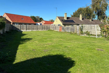 Added on 09/07/2026Building Plot
 Added on 28/08/2026Development Land
 Added on 22/06/2026Self Build Plot
 Added on 14/05/2026Self Build Plot
 Added on 14/03/2026Self Build Plot
 Added on 22/06/2026Development Land