Tigh-An-Lochan, Plot 8, Kilchrenan, Taynuilt, Argyll and Bute, PA35
- Land size
- 0.2 acres
Key Features
- Prime development plot in popular rural location
- Far reaching views towards Ben Cruachan
- Detailed planning permission for a detached residential property
- Services located close by for connection
- Commuting distance to Oban
- Wonderful village community
Description
An opportunity to acquire a development plot located in Kilchrenan, extending to approximately 0.2 acres and benefitting from detailed planning permission for the development of a residential dwelling and outbuilding.
Set in a much sought-after area on the fringe of the village of Kilchrenan, Tigh-An-Lochan, Plot 8, offers buyers an opportunity to acquire a prime residential plot, a wonderful opportunity for those looking to develop their dream home in this popular island village location.
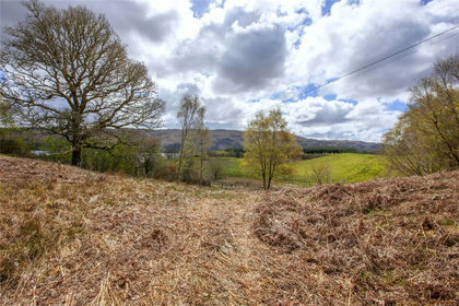
The plot is served by a shared access track, leading to the boundary which denotes the plot entrance. The land is mostly level, rising slightly to the rear with the natural contours of the land.
The plot benefits from detailed planning permission for the development of a single residential dwelling, details of which are available on the Argyll and Bute website under original planning reference 21/01634/PP.
The plans were recently amended to reconfigure the outbuilding, utilising an alternative roofing material. Further details can be found under planning reference 22/01644/NMA.
Kilchrenan is a popular village boasting a thriving community and is conveniently located around 30 minutes’ drive from Oban, a vibrant coastal town on the west coast of Scotland.
Kilchrenan supports several prestigious hotels, a church, village hall, a recently refurbished local inn and well-respected primary school. Secondary education is undertaken at Oban. Everyday requirements can be found at Taynuilt approximately 6 miles to the north. Taynuilt has a number of traditional stores including butcher, grocer and a Sub-Post Office. It has a modern doctor’s surgery, police station, two churches, a golf course, a hotel and a tea-room.
The plot is a short distance from Loch Awe, one of Scotland’s largest and most picturesque freshwater lochs with its wooded shores, ruined castle of Kilchurn and scattered small islands. It attracts numerous visitors to the area, renowned for its salmon and trout fishing, as well as enticing climbers and walkers drawn to the Cruachan and Ben Lui mountain ranges. The area is also popular with those keen on wildlife.
Further services are available in Oban, an expanding port with an attractive sea front and busy harbour, well known as the main Caledonian MacBrayne terminal and gateway to the isles.
We are informed that mains water services and electricity are located close to the plot and advise purchasers to make enquiries with the service providers to determine the cost of connection. Drainage is shared with neighbouring properties.
Take the A85 from Oban to Taynuilt. Follow the road through Taynuilt until reaching the turning to the right signposted for the B845 toward the village of Kilchrenan. Continue along this road for approximately 4.6 miles then take the private track on the right. Tigh An Lochan, Plot 8, is located on the right, clearly marked by a Bell Ingram sale board.
What3words ///disputes.craters.countries
Map Location
Property details
- Tenure
- Freehold
- Council Tax Band
- TBC
- Date Posted
- 2026-01-29
Utilities & Restrictions
Utilities
- Electricity
- Ask Agent
- Water
- Ask Agent
- Heating
- Ask Agent
- Broadband
- Ask Agent
- Sewerage
- Ask Agent
Rights & Restrictions
- Public Rights of Way
- Ask Agent
- Private Rights of Way
- Ask Agent
- Listed Property
- Ask Agent
- Restrictions
- Ask Agent
Listed status, conservation areas and planning constraints for this location are in the full report.
Property Features
- Accessibility
- Ask Agent
- Parking
- Ask Agent
- Garden
- Ask Agent
Beyond the particulars: planning activity, flood history, heritage and ground risks, checked for this exact spot.
Connectivity
Broadband
Fastest speed available at this postcode
1.8 Gbps
Gigabit full fibre · available to 50% of premises
Suitable for
- 4K streaming on every screen
- Full-time home working
- Online gaming & big downloads
Mobile signal
Outdoor predictions; indoor signal depends on building materials.
Ofcom Connected Nations postcode-level predictions. Speeds and signal are modelled, not measured, and vary between addresses and providers.
Signal is the easy part. Planning activity, flood history and protected designations here are in the full report.
Nearest Schools
Primary
- Taynuilt Primary School4.6 miles
- Pupils
- 55
- Type
- Non-denominational
- Dalmally Primary School8.5 miles
- Pupils
- 30
- Type
- Non-denominational
- Inveraray Primary School11 miles
- Pupils
- 59
- Type
- Non-denominational
- Rockfield Gaelic Unit11 miles
- Pupils
- 50
- Type
- Non-denominational
- Rockfield Primary School11 miles
- Pupils
- 236
- Type
- Non-denominational
Secondary
- Oban High School11 miles
- Pupils
- 1,009
- Type
- Non-denominational
- Kinlochleven High School25 miles
- Pupils
- 135
- Type
- Non-denominational
- Lochgilphead High School25 miles
- Pupils
- 408
- Type
- Non-denominational
- Ardnamurchan High School27 miles
- Pupils
- 126
- Type
- Non-denominational
- Dunoon Grammar School30 miles
- Pupils
- 745
- Type
- Non-denominational
Distances are straight-line from the advertised location. Source: the national school registers (DfE, Welsh Government, Scottish Government) and Ofsted.
Schools are just the start: planning activity, heritage and any flood history here are in the full report.
Amenities
Supermarket
GP surgery
Pharmacy
Walking trail
Straight-line distances from the advertised location. Sources: NHS records, Geolytix supermarket locations, OS Open Greenspace and the national trails registers.
The area stacks up? Now check the location itself: planning nearby, protected designations and past flooding.
Getting Around
Nearest station
Nearest bus stop
Typical drive times
Straight-line distances from the advertised location; drive times are typical free-flow times over OpenStreetMap road data, so allow more at peak. Public transport locations from DfT NaPTAN.
Easy to reach matters. So do planning activity, flood history and ground risks: all in the full report.
Flood Risk
From SEPA flood map open data, checked around the advertised map pin and allowing for the listed acreage where known. This summary comes from LandSale, the advertising platform, not from the listing agent, and is not part of the agent's particulars. Risk can vary across a single holding, so verify anything critical through your own searches before committing.
Rivers and the sea
Surface water
The detail behind these bandings
The full report pinpoints where this location sits on the flood maps, and runs the deeper checks that usually only surface after an offer.
- Exact flood zones & annual chances (included in the full report)
- Any recorded past flooding (included in the full report)
- Planning activity nearby (included in the full report)
- Heritage & conservation (included in the full report)
- Protected nature designations (included in the full report)
- Ground risks (included in the full report)
£14.99 · one-off purchase
By LandSale, the platform. Not provided by the listing agent. Ready in about a minute.
Important notice: Information, maps and tags on this page are drawn from the advertising agent's marketing materials or generated automatically. LandSale has not verified them. Relying on these details is at your own risk, always carry out independent checks before committing to a purchase.
LandSale full disclaimer
Marketing information only - not formal particulars. The details on this website are provided for general guidance and do not constitute an offer or contract. Neither LandSale nor the advertising estate/land agent accepts responsibility for any inaccuracy.
1. Source of information
- Listing content: Core description, asking price, tenure, measurements, photographs and planning history originate from the marketing materials of the advertising estate or land agent. LandSale does not author this content and cannot guarantee its accuracy.
- Automated tags & categorisation: Property type, land-use class, acreage bands and similar labels may be applied by machine-learning models. They are intended as a helpful guide only and may not reflect the property's legal status or permitted use.
- Third-party & enriched data layers: Maps, boundary outlines, planning designations, soil reports, broadband coverage and other environmental or location-based insights are licensed from external suppliers. Such data are supplied “as is", may be incomplete or out of date and are subject to change without notice.
2. Verification required
Prospective purchasers must verify critical matters, including but not limited to planning permission, title boundaries, public rights of way, environmental constraints, acreage, services, access and VAT status, through their own inspections, specialist surveys, legal advisers and the selling agent before relying on the information or entering into any contract.
3. No warranty or liability
LandSale gives no warranty, express or implied, as to the accuracy, completeness or fitness for any particular purpose of the information displayed. LandSale shall not be liable for any loss, damage, cost or expense arising directly or indirectly from any use of or reliance on such information, save where liability may not be excluded by law.
4. Updates & feedback
If you believe any detail on this listing is inaccurate, please let us know. We will investigate and, where appropriate, update the listing or notify the agent.
© LandSale | Version 1.3 - August 2026
Listing agent
Bell Ingram, Oban
5 Albany Street Oban PA34 4AR
Similar properties for sale
- Price
- Offers Over£79,500
- Size
- 0.57 acres
Added on 29/01/2026Building Plot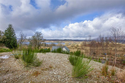
- Price
- Guide Price£85,000
- Size
- 0.38 acres
Added on 05/03/2026Building Plot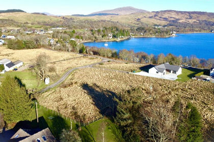
- Price
- Offers Over£95,000
- Size
- 0.41 acres
Added on 05/03/2026Building Plot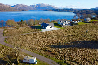
- Price
- Offers Over£85,000
- Size
- 0.41 acres
Added on 29/01/2026Building Plot
- Price
- Offers Over£74,995
Inveraray, Argyll, Bute and South Lochaber, Argyll and Bute PA32 Scotland
Added on 22/04/2026Building Plot
- Price
- Guide Price£85,000
- Size
- 0.19 acres
Added on 29/01/2026Building Plot
- Price
- Guide Price£85,000
- Size
- 0.26 acres
Added on 29/01/2026Building Plot
- Price
- Guide Price£85,000
- Size
- 0.17 acres
Added on 29/01/2026Building Plot
- Price
- Offers Over£75,000
Plot 1, Lettermay, Lochgoilhead PA24, Argyll, Bute and South Lochaber, Argyll and Bute PA24 Scotland
Added on 15/05/2026Building Plot
- Price
- Guide Price£65,000
- Size
- 0.27 acres
Added on 29/01/2026Building Plot