Development Plots (Plot 1), Calgary, Isle Of Mull, PA75
- Land size
- 0.69 acres
Description
Development Plots
Calgary, Isle of Mull, PA75 6QQ
Plot One - Offers Over £95,000
A fantastic opportunity to obtain a development plot with Planning Permission in Principle for a dwelling house located near the picturesque village of Calgary on the Isle of Mull.
Calgary less than 1 mile; Tobermory 11.7 miles; Oban (via ferry) 38.2 miles; Edinburgh Airport (via ferry) 153 miles; Glasgow Airport (via ferry) 126 miles
(all distances are approximate)
• An excellent residential development with Planning Permission in principle for a dwelling house located in a highly sought-after rural island setting.
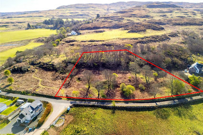
• In total extending to approximately 0.28 Hectares (0.69 acres)
• Planning Information Pack available
LOCATION
Nestled on the outskirts of the charming village of Calgary on the Isle of Mull, this property is just a short stroll away from the breathtaking Calgary Bay, renowned for its pristine white sands and crystal-clear blue waters. To the east, approximately 4.5 miles away, lies the quaint village of Dervaig, offering essential amenities such as a village store and post office.
The picturesque town of Tobermory to the east, famous for its vibrant, colourful buildings, is a popular tourist destination originally established as a fishing port in the 18th century. Tobermory boasts a wide array of amenities, including a medical practice, dentist, pharmacy, grocery stores, petrol station, bank, mechanics, library, and a variety of delightful restaurants and cafes. Primary education is available at Dervaig Primary School, while secondary education is provided at Tobermory High School. For healthcare needs, the Mull and Iona Community Hospital is located in Craignure, on the eastern side of the island. Craignure also serves as the main ferry port, offering regular services to Oban, with additional ferry connections available in Tobermory and Fishnish.
On the mainland the bustling seaside town of Oban offers an even broader range of amenities, including a leisure centre, supermarkets, restaurants, and bars. Oban Train Station provides convenient services to Glasgow and Tyndrum, while regular bus routes connect Oban to Glasgow, Edinburgh, and Fort William.
For those traveling further afield, Glasgow Airport, approximately 126 miles away (via ferry), offers a wide selection of domestic and international flights daily.
The Isle of Mull offers a variety of activities and attractions. Nature enthusiasts can enjoy wildlife tours to spot sea eagles, otters, and red deer. The island's beautiful beaches, such as Langamull and Knockvologan, are perfect for relaxation. History buffs can visit Duart Castle and Iona Abbey. For a unique experience, take a boat trip to the Isle of Staffa to see the impressive basalt columns and Fingal's Cave. Whether you're into hiking, cycling, or simply enjoying the scenery, Mull has something for everyone.
DESCRIPTION
Plot One extend to approximately 0.28 Hectares (0.69 acres).
The plot is situated in an elevated position, offering excellent views and off-street parking. Plot One has its own access.
Planning permission in principle has been granted for a dwelling house. Detailed information can be found on the Argyll and Bute Council’s Planning Portal using the following reference: 24/01430/PPP.
VIEWING
Strictly by prior agreement with the selling agents who should be contacted in advance to advise on access arrangements.
OFFERS
Offers in Scottish Legal Form should be submitted to the Selling Agents at their Perth office. Parties are asked to satisfy themselves that they fully understand the implication of offering under Scottish Law. The sellers reserve the right not to accept any offer.
FINANCIAL GUARANTEE/ANIT-MONEY LANDERING REGULATIONS
Any offer by prospective purchaser(s), regardless of where they are ordinarily resident and regardless whether on a cash or subject to loan finance basis, must be accompanied by a financial reference from a bank/funding source that is acceptable to the sellers. Prospective purchasers will also be required to produce identification sufficient to satisfy anti money laundering regulations and checks against the intended purchaser or nominee together with other documentation that may be required, from time to time, in order to support any conditional offers submitted to the seller. Bidwells LLP accepts no liability of any type arising from your delay or other lack of co-operation in this regard. Failure to provide the requisite AML documentation with offers may result in them not being considered at the closing date or being superseded by an offer which is. Settlement may also be delayed or aborted due to non-compliance with requests for information or failure to deliver adequate information within the requisite timeframes. We may hold your name on our database unless you instruct us otherwise.
Map Location
Property details
- Tenure
- Freehold
- Council Tax Band
- TBC
- Date Posted
- 2026-01-29
Property Brochure
Seen the details? The full report adds the independent checks: planning activity, flood history, heritage and ground.
Utilities & Restrictions
Utilities
- Electricity
- Ask Agent
- Water
- Ask Agent
- Heating
- Ask Agent
- Broadband
- Ask Agent
- Sewerage
- Ask Agent
Rights & Restrictions
- Public Rights of Way
- Ask Agent
- Private Rights of Way
- Ask Agent
- Listed Property
- Ask Agent
- Restrictions
- Ask Agent
Listed status, conservation areas and planning constraints for this location are in the full report.
Property Features
- Accessibility
- Ask Agent
- Parking
- Parking Available
- Garden
- Ask Agent
Beyond the particulars: planning activity, flood history, heritage and ground risks, checked for this exact spot.
Connectivity
Broadband
Fastest speed available at this postcode
1.8 Gbps
Gigabit full fibre · available to 42% of premises
Suitable for
- 4K streaming on every screen
- Full-time home working
- Online gaming & big downloads
Mobile signal
Predicted 4G and 5G signal; indoor signal depends on building materials.
Ofcom Connected Nations postcode-level predictions. Speeds and signal are modelled, not measured, and vary between addresses and providers.
Signal is the easy part. Planning activity, flood history and protected designations here are in the full report.
Nearest Schools
Primary
- Dervaig Primary School3.3 miles
- Pupils
- 15
- Type
- Non-denominational
- Tobermory High School8.2 miles
- Pupils
- 73
- Type
- Non-denominational
- Ulva Primary School8.5 miles
- Pupils
- 9
- Type
- Non-denominational
- Kilchoan Primary School10 miles
- Pupils
- 13
- Type
- Non-denominational
- Arinagour Primary School10 miles
- Pupils
- 4
- Type
- Non-denominational
Secondary
- Tobermory High School8.2 miles
- Pupils
- 151
- Type
- Non-denominational
- Tiree High School25 miles
- Pupils
- 37
- Type
- Non-denominational
- Ardnamurchan High School28 miles
- Pupils
- 126
- Type
- Non-denominational
- Oban High School33 miles
- Pupils
- 1,009
- Type
- Non-denominational
- Mallaig High School33 miles
- Pupils
- 101
- Type
- Non-denominational
Distances are straight-line from the advertised location. Source: the national school registers (DfE, Welsh Government, Scottish Government) and Ofsted.
Schools are just the start: planning activity, heritage and any flood history here are in the full report.
Amenities
Supermarket
GP surgery
Pharmacy
Walking trail
Straight-line distances from the advertised location. Sources: NHS records, Geolytix supermarket locations, OS Open Greenspace and the national trails registers.
The area stacks up? Now check the location itself: planning nearby, protected designations and past flooding.
Getting Around
Nearest station
Nearest bus stop
Typical drive times
Straight-line distances from the advertised location; drive times are typical free-flow times over OpenStreetMap road data, so allow more at peak. Public transport locations from DfT NaPTAN.
Easy to reach matters. So do planning activity, flood history and ground risks: all in the full report.
Flood Risk
SEPA open data, checked around the advertised map pin for the listed acreage. The map pin for this listing is approximate, so these readings describe the surrounding area. Provided by LandSale, not the listing agent, and not part of the agent's particulars. Risk varies across a holding, so verify before committing.
Rivers and the sea
Surface water
These bandings are the summary. Where this location sits on the flood maps, plus planning activity, heritage and ground risks, is in the full report.
Important notice: Information, maps and tags on this page are drawn from the advertising agent's marketing materials or generated automatically. LandSale has not verified them. Relying on these details is at your own risk, always carry out independent checks before committing to a purchase.
LandSale full disclaimer
Marketing information only - not formal particulars. The details on this website are provided for general guidance and do not constitute an offer or contract. Neither LandSale nor the advertising estate/land agent accepts responsibility for any inaccuracy.
1. Source of information
- Listing content: Core description, asking price, tenure, measurements, photographs and planning history originate from the marketing materials of the advertising estate or land agent. LandSale does not author this content and cannot guarantee its accuracy.
- Automated tags & categorisation: Property type, land-use class, acreage bands and similar labels may be applied by machine-learning models. They are intended as a helpful guide only and may not reflect the property's legal status or permitted use.
- Third-party & enriched data layers: Maps, boundary outlines, planning designations, soil reports, broadband coverage and other environmental or location-based insights are licensed from external suppliers. Such data are supplied “as is", may be incomplete or out of date and are subject to change without notice.
2. Verification required
Prospective purchasers must verify critical matters, including but not limited to planning permission, title boundaries, public rights of way, environmental constraints, acreage, services, access and VAT status, through their own inspections, specialist surveys, legal advisers and the selling agent before relying on the information or entering into any contract.
3. No warranty or liability
LandSale gives no warranty, express or implied, as to the accuracy, completeness or fitness for any particular purpose of the information displayed. LandSale shall not be liable for any loss, damage, cost or expense arising directly or indirectly from any use of or reliance on such information, save where liability may not be excluded by law.
4. Updates & feedback
If you believe any detail on this listing is inaccurate, please let us know. We will investigate and, where appropriate, update the listing or notify the agent.
© LandSale | Version 1.3 - August 2026

Listing agent
Bidwells, Rural
Bidwell House, Trumpington Road, Cambridge, CB2 9LD
Similar properties for sale
- Price
- Offers Over£80,000
- Size
- 0.62 acres
Development Plots (Plot 3), Calgary, Isle Of Mull, PA75, Isle Of Mull, Argyll and Bute PA75 Scotland
Added on 29/01/2026Building Plot- Price
- Offers Over£90,000
- Size
- 0.67 acres
Development Plots (Plot 2), Calgary, Isle Of Mull, PA75, Isle Of Mull, Argyll and Bute PA75 Scotland
Added on 29/01/2026Building Plot
- Price
- Offers Over£75,000
- Size
- 0.4 acres
Added on 14/10/2026Building Plot
- Price
- Guide Price£85,000
- Size
- 0.6 acres
Added on 30/05/2026Building Plot
- Price
- Guide Price£90,000
- Size
- 0.36 acres
Added on 29/01/2026Building Plot
- Price
- £110,000
- Size
- 0.38 acres
Acharacle, PH36, Argyll, Bute and South Lochaber, Highland PH36 Scotland
Added on 22/09/2026Building Plot
- Price
- £110,000
- Size
- 0.32 acres
Acharacle, PH36, Argyll, Bute and South Lochaber, Highland PH36 Scotland
Added on 22/09/2026Building Plot
- Price
- Guide Price£85,000
- Size
- 0.66 acres
Added on 29/01/2026Building Plot
- Price
- Offers Over£125,000
- Size
- 0.44 acres
Added on 28/01/2026Building Plot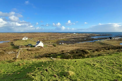
- Price
- Guide Price£79,000
- Size
- 0.3 acres
Added on 20/05/2026Building Plot