Troon
Key Features
- Building Plots
- Planning Consent For 2 Dwellings
- Proposed Accommodation
- Three Bedrooms
- Kitchen/Dining Room
- Sitting Room
- Cloakroom And Bathroom
- Private Rear Gardens
- Parking For Two And Three Cars
- Building Regulations Submitted
Description
BUILDING PLOTS FOR TWO SEMI DETACHED HOUSES IN TUCKED AWAY LOCATION
In a quiet position within this popular village and just a short walk of shops and post office.
Proposed accommodation for both houses is three bedrooms, kitchen/dining room, sitting room, cloakroom and bathroom. Private rear gardens and allocated parking.
Building regulations have been submitted and a technical start has taken place to keep the planning live.
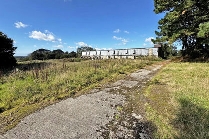
Also available a traditional stone barn with planning permission for conversion.
Further information from the sole agents.
General Comments - An excellent opportunity to purchase building plots located in a quiet setting within the village of Troon on the outskirts of Camborne. Planning permission was granted by Cornwall Council Reference PA20/05854 on 22 February 2021 for the "Construction of two residential dwellings".
The two houses will be semi detached and the plots are located in a quiet tucked away position. The planning is all in place, building regulations have been submitted and a technical start has been started on site to keep the planning live. The outbuildings have been demolished and the access road built. The mining remediation works have also been carried out by a mining specialist. The report can be inspected at the sole agents if required. Both houses will have private rear gardens and allocated parking. The proposed accommodation for both is three bedrooms and bathroom on the first floor with kitchen/dining room, sitting room and cloakroom downstairs.
It is believed that services are close by but purchasers will need to satisfy themselves of this. Further details are available from the sole agents.
Conditions - 1 The development hereby permitted shall be begun before the expiration of 3 years from the date of this permission.
2 The development hereby permitted shall be carried out in accordance with the plans listed below under the heading "Plans Referred to in Consideration of this Application".
3 Contaminated Land 'Risk Assessment' No development, other than demolition of any buildings or structures, shall commence until an assessment of the risks posed by any contamination shall have been submitted to and approved in writing by the local planning authority.
This assessment must be undertaken by a suitably qualified contaminated land practitioner, in accordance with British Standard BS 10175: Investigation of potentially contaminated sites - Code of Practice and the Environment Agency's Model Procedures for the Management of Land Contamination (CLR 11) (or equivalent British Standard and Model Procedures if replaced), and shall assess any contamination on the site, whether or not it originates on the site. The assessment shall include: a) a survey of the extent, scale and nature of contamination; b) the potential risks to: human health; ' property (existing or proposed) including buildings, crops, livestock, pets, woodland and service lines and pipes; ' adjoining land; ' ground waters and surface waters; ' ecological systems; and ' archaeological sites and ancient monuments.
4 Contaminated Land 'Remediation Scheme' Following the risk assessment, where land is found to be affected by contamination and pose risks identified as being unacceptable, no development shall take place until a detailed remediation scheme shall have been submitted to and approved in writing by the Local Planning Authority. The scheme shall include an appraisal of remediation options, identification of the preferred
option(s), the proposed remediation objectives and remediation criteria, and a description and programme of the works to be undertaken including the verification plan. The remediation scheme shall be sufficiently detailed and thorough to ensure that upon completion the site will not qualify as contaminated land under Part IIA of the Environmental Protection Act 1990 in relation to its intended use.
A pre-commencement condition is required in this case because it is essential to establish before any works takes place the nature and extent of any ground contamination in order to safeguard the health of workers taking part in the development of the site and to ensure the appropriate design and subsequent safe occupation of the development.
5 Contaminated Land 'Verification Report following Remediation Scheme' The approved remediation scheme in condition (4) shall be carried out and upon completion a verification report by a suitably qualified contaminated land practitioner shall be submitted to and approved in writing by the local planning authority before the development is occupied.
6 Contaminated Land 'Reporting of Unexpected Contamination' Any contamination that is found during the course of construction of the approved development that was not previously identified shall be reported in writing immediately to the local planning authority. Development on the part of the site affected shall be suspended and a risk assessment carried out and submitted to and approved in writing by the local planning authority. Where unacceptable risks are found remediation and verification schemes shall be submitted to and approved in writing by the local planning authority. These approved schemes shall be carried out before the development is resumed or continued.
7 Before any of the development hereby permitted is brought into use, parking areas shall be laid out and constructed in accordance with approved drawing no.1084.19B and the said areas shall not thereafter be obstructed or used for any other purpose.
8 Notwithstanding the provisions of the Town and Country Planning (General Permitted Development) (England) Order 2015 (as amended) (or any order revoking, re-enacting or modifying that Order), no development within Classes A, C, D and E of Part 1 of Schedule 2 to the said Order shall be carried out without an express grant of planning permission, namely: o The enlargement, improvement or other alteration of the dwellinghouse; o The enlargement of the dwellinghouse consisting of an addition or alteration to its roof; o Any other alterations to the roof of the dwellinghouse; o The erection of construction of a porch outside any external door of the dwelling The provision within the curtilage of the dwellinghouse of any building or enclosure, swimming or other pool required for a purpose incidental to the enjoyment of the dwellinghouse as such, or the maintenance, improvement or other alteration of such a building or enclosure.
9 Before the development hereby permitted is commenced a pre-construction site investigation shall be undertaken to in order to clarify the possible presence, or otherwise, of any untoward mining excavations or other man-made or naturally occurring conditions, which may present a risk of potential surface instability. The findings of the site investigations shall be submitted to and approved in writing by the Local Planning Authority. Should any further investigations or remediation works be required this information shall be submitted to and approved in writing by the Local Planning Authority. The development shall be carried out in accordance with the recommendations in the submitted reports.
A pre-commencement condition is necessary to ensure suitable site conditions
Viewing - Strictly by Appointment through the Agents Philip Martin, 9 Cathedral Lane, Truro, TR1 2QS. Telephone: or 3 Quayside Arcade, St. Mawes, Truro TR2 5DT. Telephone .
Directions - Proceeding through Troon village along Newton Road, turn right just as you enter Fore Street and just passed the left hand turning signed "Leading To Chapel Farm". Follow this unmade lane and the entrance to the barns is on the right hand side.
Map Location
Property details
- Tenure
- Freehold
- Council Tax Band
- Ask Agent
- Date Posted
- 2026-01-29
Utilities & Restrictions
Utilities
- Electricity
- Ask Agent
- Water
- Ask Agent
- Heating
- Ask Agent
- Broadband
- Ask Agent
- Sewerage
- Ask Agent
Rights & Restrictions
- Public Rights of Way
- Ask Agent
- Private Rights of Way
- Ask Agent
- Listed Property
- Ask Agent
- Restrictions
- Ask Agent
Listed status, conservation areas and planning constraints for this location are in the full report.
Property Features
- Accessibility
- Ask Agent
- Parking
- Parking Available
- Garden
- Garden
Beyond the particulars: planning activity, flood history, heritage and ground risks, checked for this exact spot.
Connectivity
Broadband
Fastest speed available at this postcode
1.8 Gbps
Gigabit full fibre
Suitable for
- 4K streaming on every screen
- Full-time home working
- Online gaming & big downloads
Fixed wireless access may also be an option here.
Mobile signal
Predicted 4G and 5G signal; indoor signal depends on building materials.
Ofcom Connected Nations postcode-level predictions. Speeds and signal are modelled, not measured, and vary between addresses and providers.
Signal is the easy part. Planning activity, flood history and protected designations here are in the full report.
Nearest Schools
Primary
- Troon Community Primary School418 metresNo Ofsted rating
- Ages
- 2 to 11
- Pupils
- 141
- Type
- Academy converter
- St John's Catholic Primary School, Camborne1.1 milesOfsted report card · Feb 2026
- Ages
- 4 to 11
- Pupils
- 149
- Type
- Academy converter
- Faith
- Roman Catholic
- Trevithick Learning Academy1.2 milesOfsted: Good
- Ages
- 2 to 11
- Pupils
- 520
- Type
- Academy converter
- Roskear Primary & Nursery School1.4 milesNo Ofsted rating
- Ages
- 2 to 11
- Pupils
- 404
- Type
- Academy converter
- Penponds School1.5 milesOfsted: Good
- Ages
- 4 to 11
- Pupils
- 104
- Type
- Academy converter
Secondary
- Camborne Science and International Academy1.9 milesOfsted: Good
- Ages
- 11 to 18
- Pupils
- 1,751
- Type
- Academy converter
- Pool Academy2.2 milesOfsted report card · Mar 2026
- Ages
- 11 to 16
- Pupils
- 714
- Type
- Academy converter
- Redruth School3.1 milesNo Ofsted rating
- Ages
- 11 to 16
- Pupils
- 1,433
- Type
- Foundation school
- Hayle Academy5.9 milesOfsted report card · Jun 2026
- Ages
- 11 to 16
- Pupils
- 623
- Type
- Academy converter
- Helston Community College6.3 milesOfsted: Good
- Ages
- 0 to 18
- Pupils
- 1,297
- Type
- Academy converter
Distances are straight-line from the advertised location. Source: the national school registers (DfE, Welsh Government, Scottish Government) and Ofsted.
Schools are just the start: sold prices nearby, planning activity and any flood history are in the full report.
Amenities
Supermarket
GP surgery
Pharmacy
Hospital
Green space
Straight-line distances from the advertised location. Sources: NHS records, Geolytix supermarket locations, OS Open Greenspace and the national trails registers.
The area stacks up? Now check the location itself: planning nearby, protected designations and past flooding.
Getting Around
Nearest station
Nearest bus stop
Typical drive times
Straight-line distances from the advertised location; drive times are typical free-flow times over OpenStreetMap road data, so allow more at peak. Public transport locations from DfT NaPTAN.
Easy to reach matters. So do planning activity, flood history and ground risks: all in the full report.
Flood Risk
Environment Agency open data, checked around the advertised map pin for the listed acreage. Long-term risk counts flood defences; the planning map's flood zones do not. Provided by LandSale, not the listing agent, and not part of the agent's particulars. Risk varies across a holding, so verify before committing.
Rivers and the sea
Planning map: Flood Zone 1.
Surface water
These bandings are the summary. Where this location sits on the flood maps, plus planning activity, heritage and ground risks, is in the full report.
Important notice: Information, maps and tags on this page are drawn from the advertising agent's marketing materials or generated automatically. LandSale has not verified them. Relying on these details is at your own risk, always carry out independent checks before committing to a purchase.
LandSale full disclaimer
Marketing information only - not formal particulars. The details on this website are provided for general guidance and do not constitute an offer or contract. Neither LandSale nor the advertising estate/land agent accepts responsibility for any inaccuracy.
1. Source of information
- Listing content: Core description, asking price, tenure, measurements, photographs and planning history originate from the marketing materials of the advertising estate or land agent. LandSale does not author this content and cannot guarantee its accuracy.
- Automated tags & categorisation: Property type, land-use class, acreage bands and similar labels may be applied by machine-learning models. They are intended as a helpful guide only and may not reflect the property's legal status or permitted use.
- Third-party & enriched data layers: Maps, boundary outlines, planning designations, soil reports, broadband coverage and other environmental or location-based insights are licensed from external suppliers. Such data are supplied “as is", may be incomplete or out of date and are subject to change without notice.
2. Verification required
Prospective purchasers must verify critical matters, including but not limited to planning permission, title boundaries, public rights of way, environmental constraints, acreage, services, access and VAT status, through their own inspections, specialist surveys, legal advisers and the selling agent before relying on the information or entering into any contract.
3. No warranty or liability
LandSale gives no warranty, express or implied, as to the accuracy, completeness or fitness for any particular purpose of the information displayed. LandSale shall not be liable for any loss, damage, cost or expense arising directly or indirectly from any use of or reliance on such information, save where liability may not be excluded by law.
4. Updates & feedback
If you believe any detail on this listing is inaccurate, please let us know. We will investigate and, where appropriate, update the listing or notify the agent.
© LandSale | Version 1.3 - August 2026
Listing agent
Philip Martin, Truro
9 Cathedral Lane, Truro, TR1 2QS
Similar properties for sale
- Price
- Offers Over£200,000
- Size
- 1 acres
Crowan, Praze-An-Beeble, Camborne, Cornwall, Crowan, Cornwall TR14 England
Added on 27/05/2026Development Land
- Price
- Guide Price£160,000
Added on 08/09/2026Building Plot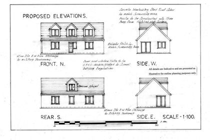
- Price
- Guide Price£170,000
Fantastic Building Plot, Carnkie, Wendron, Cornwall TR13 England
Added on 12/03/2026Building Plot
- Price
- Offers in Excess of£200,000
- Size
- 0.19 acres
Development Land, adjacent to Chapel Farm, North Country, Redruth, Cornwall TR16 England
Added on 17/07/2026Development Land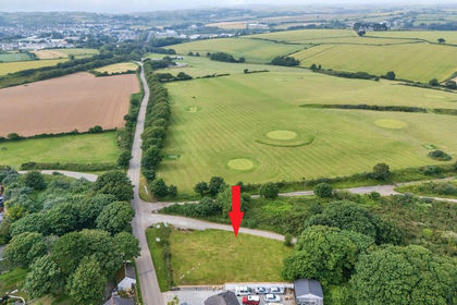
- Price
- Offers in Excess of£250,000
Wheal Alfred Road, Hayle, Cornwall, Hayle, Cornwall TR27 England
Added on 02/07/2026Building Plot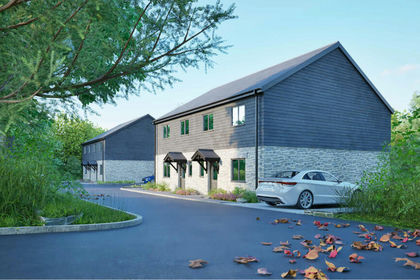
- Price
- £250,000
Added on 20/02/2026Building Plot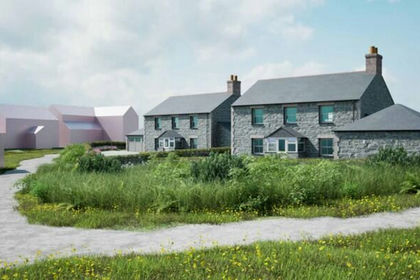
- Price
- Guide Price£210,000
Added on 11/08/2026Building Plot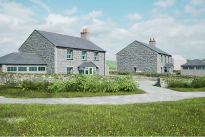
- Price
- Guide Price£185,000
Added on 11/08/2026Building Plot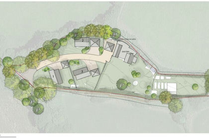
- Price
- Guide Price£175,000
Added on 28/01/2026Building Plot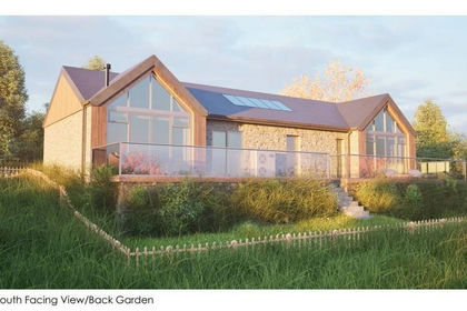
- Price
- Guide Price£250,000
Tregarthen, rare chance to create a unique home, Ludgvan, Cornwall TR20 England
Added on 03/02/2026Conversion Land