Market Place, Alston, Cumbria, CA9
Key Features
- North Pennines location
- Historic pub dating back to 1646
- England's highest town
- Two section trade area
- Front & rear trade yards
- 3 bed owners accommodation and office
- Net turnover £132,219 for year ending March 2023
Description
he Turks Head is located in the Cumbrian Town of Alston and shares the title of England's highest town at 1,000 foot above sea level. The town is situated in the North Pennines set on the upper reaches of the River South Tyne and in an Area of Outstanding Natural Beauty.
The town sits on the main A686 from Penrith taking in stunning scenery and voted one of the top driving routes in Britain. The town of Hexham can be reached via the A69 northbound. The Pennine Way footpath and the Sea to Sea (C2C) cycle route also passes through the town.
The property holds a mid terrace position in the cobbled market square and dates back to 1646 with brick construction under a pitched tiled roof and offers cosy and comfortable setting with Old Worlde décor.
Map Location
Property details
- Tenure
- Freehold
- Council Tax Band
- Ask Agent
- Date Posted
- 2026-01-29
Utilities & Restrictions
Utilities
- Electricity
- Ask Agent
- Water
- Ask Agent
- Heating
- Ask Agent
- Broadband
- Ask Agent
- Sewerage
- Ask Agent
Rights & Restrictions
- Public Rights of Way
- Ask Agent
- Private Rights of Way
- Ask Agent
- Listed Property
- Ask Agent
- Restrictions
- Ask Agent
Property Features
- Accessibility
- Ask Agent
- Parking
- Ask Agent
- Garden
- Garden
Important notice: Information, maps and tags on this page are supplied by the advertising agent or generated automatically. LandSale has not verified them. Relying on these details is at your own risk, always carry out independent checks before committing to a purchase.
LandSale full disclaimer
Marketing information only - not formal particulars. The details on this website are provided for general guidance and do not constitute an offer or contract. Neither LandSale nor the advertising estate/land agent accepts responsibility for any inaccuracy.
1. Source of information
- Agent-supplied content: Core description, asking price, tenure, measurements, photographs and planning history are uploaded by the appointed agent, who remains solely responsible for their accuracy.
- Automated tags & categorisation: Property type, land-use class, acreage bands and similar labels may be applied by machine-learning models. They are intended as a helpful guide only and may not reflect the property's legal status or permitted use.
- Third-party & enriched data layers: Maps, boundary outlines, planning designations, soil reports, broadband coverage and other environmental or location-based insights are licensed from external suppliers. Such data are supplied “as is", may be incomplete or out of date and are subject to change without notice.
2. Verification required
Prospective purchasers must verify critical matters, including but not limited to planning permission, title boundaries, public rights of way, environmental constraints, acreage, services, access and VAT status, through their own inspections, specialist surveys, legal advisers and the selling agent before relying on the information or entering into any contract.
3. No warranty or liability
LandSale gives no warranty, express or implied, as to the accuracy, completeness or fitness for any particular purpose of the information displayed. LandSale shall not be liable for any loss, damage, cost or expense arising directly or indirectly from any use of or reliance on such information, save where liability may not be excluded by law.
4. Updates & feedback
If you believe any detail on this listing is inaccurate, please let us know. We will investigate and, where appropriate, update the listing or notify the agent.
© LandSale | Version 1.2 - January 2026
Listing agent
Sidney Phillips Limited, Northern
Northern
Similar properties for sale

- Price
- £200,000
Northumberland - Beautifully Presented Public House, Haltwhistle, Northumberland NE49 9HP England
Added on 29/01/2026Commercial Land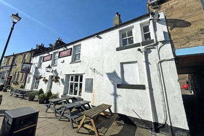 Added on 17/06/2026Pub
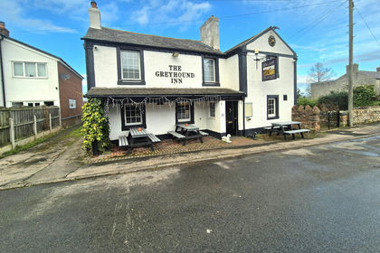
- Price
- £295,000
Added on 17/07/2026Pub
- Price
- £260,000
- Size
- 0.08 acres
Added on 17/07/2026Workshop Added on 29/01/2026Pub
- Price
- £230,000
Inkerman Road Industrial Estate, Tow Law, Bishop Auckland, Tow Law, County Durham DL13 4QB England
Added on 09/07/2026Development Land
- Price
- From£200,000
Added on 04/06/2026Industrial Land
- Price
- From£200,000
Hutton Court, Consett, County Durham, DH8 6BN, Blaydon and Consett, County Durham DH8 6BN England
Added on 02/06/2026Industrial Land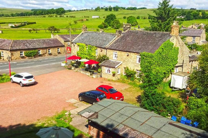
- Price
- Offers in Excess of£295,000
- Size
- 0.81 acres
Added on 17/07/2026Pub
- Price
- Guide Price£270,000
- Size
- 0.08 acres
Added on 16/04/2026Commercial Land