Writhlington, Near Radstock
- Land size
- 0.62 acres
Key Features
- Full planning permission for 6 dwellings
- Close to the centre of Radstock and a good range of facilities
- Site area of 2500 sq.m. (0.62 acres)
- Extensive road frontage
- Access through Orchid Way
- Proximity to services
Description
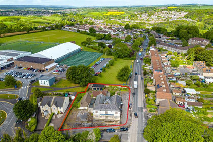
An excellent development site situated at Writhlington on the edge of Radstock with planning permission for the erection of six dwellings.
Description
The sale of this land is a rare opportunity to acquire a development site close to the centre of a popular rural town conveniently located in the Somerset countryside and offering a good range of facilities. The property comprises a level piece of agricultural land that is bound by hedges and fences on three sides. In total the site extends to 0.62 acres.
Full planning consent (ref 2024/0334/REM) has been granted by Somerset Council for the erection of six dwellings each providing three bedroom accommodations (1000 sq.ft.).
The plans provide for the erection of garages and the provision of gardens. There are no CIL or s106 obligations.
Location
The land is situated adjoining the A362 at Writhlington close to the centre of Radstock which is a popular town with a good range of facilities including a primary & secondary school and sixth form, a doctor’s surgery, a small supermarket, three public houses and sporting facilities, many of which are nearby. The village is situated in the heart of the Somerset countryside.
Radstock is within easy commuting distance of Bath, Bristol and the Somerset market towns. A bus service can be found just over 100m from the site and next to the Writhlington leisure centre and school.
Although in a rural location, there is straight-forward access to the local road network. Bath is 8.5 miles to the north with Midsomer Norton being 3 miles to the west, Wells 7 miles to the south east and the regional centre of Bristol, 17 miles to north west.
Main line trains run from Frome train station (7.6 miles).Bristol Airport is a 40-minute drive away.
Situation
The land fronts on to the A362 with residential properties to the left and opposite.
Services
Mains water; electricity and drainage are understood to be in the vicinity of the site. However, all interested parties should make and rely upon their own enquiries of the relevant service providers with regards to the proposed development.
Local Authorities
Somerset County Council
County Hall
Taunton
Somerset
TA1 4DY
Map Location
Property details
- Tenure
- Freehold
- Council Tax Band
- TBC
- Date Posted
- 2026-01-29
Utilities & Restrictions
Utilities
- Electricity
- Ask Agent
- Water
- Ask Agent
- Heating
- Ask Agent
- Broadband
- Ask Agent
- Sewerage
- Ask Agent
Rights & Restrictions
- Public Rights of Way
- Ask Agent
- Private Rights of Way
- Ask Agent
- Listed Property
- Ask Agent
- Restrictions
- Ask Agent
Property Features
- Accessibility
- Ask Agent
- Parking
- Parking Available
- Garden
- Garden
Important notice: Information, maps and tags on this page are supplied by the advertising agent or generated automatically. LandSale has not verified them. Relying on these details is at your own risk, always carry out independent checks before committing to a purchase.
LandSale full disclaimer
Marketing information only - not formal particulars. The details on this website are provided for general guidance and do not constitute an offer or contract. Neither LandSale nor the advertising estate/land agent accepts responsibility for any inaccuracy.
1. Source of information
- Agent-supplied content: Core description, asking price, tenure, measurements, photographs and planning history are uploaded by the appointed agent, who remains solely responsible for their accuracy.
- Automated tags & categorisation: Property type, land-use class, acreage bands and similar labels may be applied by machine-learning models. They are intended as a helpful guide only and may not reflect the property's legal status or permitted use.
- Third-party & enriched data layers: Maps, boundary outlines, planning designations, soil reports, broadband coverage and other environmental or location-based insights are licensed from external suppliers. Such data are supplied “as is", may be incomplete or out of date and are subject to change without notice.
2. Verification required
Prospective purchasers must verify critical matters, including but not limited to planning permission, title boundaries, public rights of way, environmental constraints, acreage, services, access and VAT status, through their own inspections, specialist surveys, legal advisers and the selling agent before relying on the information or entering into any contract.
3. No warranty or liability
LandSale gives no warranty, express or implied, as to the accuracy, completeness or fitness for any particular purpose of the information displayed. LandSale shall not be liable for any loss, damage, cost or expense arising directly or indirectly from any use of or reliance on such information, save where liability may not be excluded by law.
4. Updates & feedback
If you believe any detail on this listing is inaccurate, please let us know. We will investigate and, where appropriate, update the listing or notify the agent.
© LandSale | Version 1.2 - January 2026
Listing agent
Killens, Wells
10 Sadler Street, Wells, BA5 2SE
Similar properties for sale
- Price
- Guide Price£350,000
Added on 28/05/2026Development Land
- Price
- £400,000
- Size
- 0.12 acres
Added on 29/01/2026Development Land
- Price
- Guide Price£475,000
Added on 02/07/2026Industrial Land
- Price
- £300,000
Added on 16/05/2026Development Land
- Price
- £500,000
- Size
- 0.8 acres
Added on 29/01/2026Development Land Added on 26/03/2026Building Plot
- Price
- Guide Price£350,000
- Size
- 5.4 acres
The Barn at Oldford with full planning, Oldford, Frome, BA11, Selwood, Somerset BA11 2ND England
Added on 12/02/2026Conversion Land
- Price
- £350,000
- Size
- 0.27 acres
Development Site at Stowey, Stowey-Sutton, Bath and North East Somerset BS39 5TH England
Added on 15/07/2026Development Land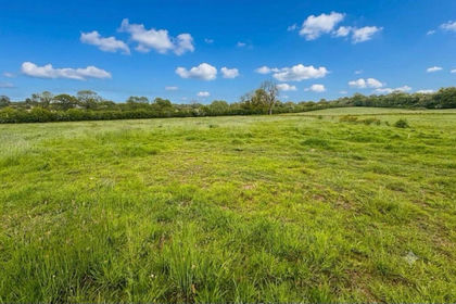
- Price
- Guide Price£400,000
- Size
- 7 acres
Added on 23/05/2026Building Plot
- Price
- Guide Price£300,000
- Size
- 0.4 acres
Self-build Plot, Crosombe, Croscombe, Somerset BA5 3QW England
Added on 20/02/2026Building Plot