Cellan, Lampeter, SA48
- Land size
- 35.88 acres
Key Features
- CELLAN, LAMPETER
- 35.878 acres with old ruin
- Footings of former Shepherd's cottage
- Attractive conservation lake
- Divided into series of enclosures
- Potential alternative use (s.t.c.)
- Overlooking Teifi Valley.
Description
*** 3 miles from the University Town of Lampeter, above the Teifi Valley, and accessed via a quiet district road and right of way (Please refer to Plans) *** This extremely rare opportunity includes a block of grazing land around 1,000ft above Sea level overlooking the Teifi Valley with far reaching views over the surrounding unspoilt countryside
*** The land includes the footings of a former Shepherd's cottage and a most attractive conservation lake which is a haven for Wildlife *** The land was divided into a series of enclosures and contained within a ring fence *** The land is a valuable and rare opportunity for those seeking complete solitude and offers potential alternative use (subject to the appropriate consents being obtained)
*** The land in total extends to 35.878 acres (14.519 hectares)
No services connected or available.
GENERAL DESCRIPTION
Talyfan Mountain Land enjoys a breath taking location above the Teifi Valley with far reaching views across the surrounding unspoilt countryside. It lies in one of the most secluded locations currently available and offered to the market.
The land is presently only accessed by a 4x4 vehicle, agricultural vehicles or by foot. Please refer to plan for access and park at the end of the road near Talyfan.
You are advised NOT to access the property at present other than a 4x4 vehicle and you must keep Dogs on a lead at all times.
This is an unusually rare opportunity in that it offers a secluded block of land with considerable conservation potential for uses such as tree planting, conservation purposes and the creation of a nature reserve or similar in that it includes a very attractive conservation lake and various pockets of wet land that are known to be high in conservation value.
The land is interspersed by natural water sources and is c...
RUIN
SITE OF RUIN
LAKE SETTING (FIRST IMAGE)
LAKE SETTING (SECOND IMAGE)
LAKE SETTING (THIRD IMAGE)
LAKE SETTING (FOURTH IMAGE)
LAKE SETTING (FIFTH IMAGE)
LAKE SETTING (SIXTH IMAGE)
LAKE SETTING (SEVENTH IMAGE)
PLANNING AUTHORITY
Ceredigion County Council. Tel: .
NOTE
A parcel of nearby land amounting to 26.67 acres (Talyfan Fields) is also available to purchase. Further sales particulars are available from the Sole Selling Agents.
Map Location
Property details
- Tenure
- Freehold
- Council Tax Band
- Ask Agent
- Date Posted
- 2026-01-29
Market Value Analysis
Compared with 96 Farmland & Pasture listings in Wales (25+ acres).
Utilities & Restrictions
Utilities
- Electricity
- Ask Agent
- Water
- Ask Agent
- Heating
- Ask Agent
- Broadband
- Ask Agent
- Sewerage
- Ask Agent
Rights & Restrictions
- Public Rights of Way
- Ask Agent
- Private Rights of Way
- Ask Agent
- Listed Property
- Ask Agent
- Restrictions
- Ask Agent
Property Features
- Accessibility
- Ask Agent
- Parking
- Ask Agent
- Garden
- Ask Agent
Important notice: Information, maps and tags on this page are supplied by the advertising agent or generated automatically. LandSale has not verified them. Relying on these details is at your own risk, always carry out independent checks before committing to a purchase.
LandSale full disclaimer
Marketing information only - not formal particulars. The details on this website are provided for general guidance and do not constitute an offer or contract. Neither LandSale nor the advertising estate/land agent accepts responsibility for any inaccuracy.
1. Source of information
- Agent-supplied content: Core description, asking price, tenure, measurements, photographs and planning history are uploaded by the appointed agent, who remains solely responsible for their accuracy.
- Automated tags & categorisation: Property type, land-use class, acreage bands and similar labels may be applied by machine-learning models. They are intended as a helpful guide only and may not reflect the property's legal status or permitted use.
- Third-party & enriched data layers: Maps, boundary outlines, planning designations, soil reports, broadband coverage and other environmental or location-based insights are licensed from external suppliers. Such data are supplied “as is", may be incomplete or out of date and are subject to change without notice.
2. Verification required
Prospective purchasers must verify critical matters, including but not limited to planning permission, title boundaries, public rights of way, environmental constraints, acreage, services, access and VAT status, through their own inspections, specialist surveys, legal advisers and the selling agent before relying on the information or entering into any contract.
3. No warranty or liability
LandSale gives no warranty, express or implied, as to the accuracy, completeness or fitness for any particular purpose of the information displayed. LandSale shall not be liable for any loss, damage, cost or expense arising directly or indirectly from any use of or reliance on such information, save where liability may not be excluded by law.
4. Updates & feedback
If you believe any detail on this listing is inaccurate, please let us know. We will investigate and, where appropriate, update the listing or notify the agent.
© LandSale | Version 1.2 - January 2026
Listing agent
Morgan & Davies, Lampeter
12 Harford Square, Lampeter, SA48 7DT
Similar properties for sale
 Added on 29/01/2026Development Land
- Price
- £105,000
Adjacent to Cross Hands Hotel, Llanybydder, SA40, Llanybydder, Carmarthenshire SA40 9TX Wales
Added on 29/01/2026Building Plot Added on 13/02/2026Building Plot
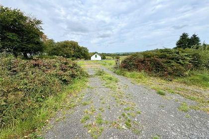
- Price
- £200,000
- Size
- 2.3 acres
Llangeitho, Tregaron, Ceredigion, SY25, Llangeitho, Ceredigion SY25 6SZ Wales
Added on 29/01/2026Stable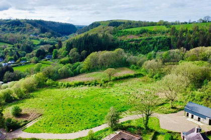
- Price
- Guide Price£115,000
- Size
- 3 acres
Gwernogle, Carmarthen, SA32, Llanfihangel Rhos-y-Corn, Carmarthenshire SA32 7RY Wales
Added on 15/05/2026Smallholding
- Price
- £175,000
- Size
- 0.33 acres
Cilcennin, Aberaeron, SA48, Ciliau Aeron, Ceredigion SA48 8RT Wales
Added on 28/01/2026Development Land
- Price
- £135,000
Added on 29/01/2026Derelict property Added on 29/01/2026Barn Conversion
 Added on 29/01/2026Building Plot
 Added on 17/03/2026Building Plot