Roston, Ashbourne
- Land size
- 0.7 acres
Key Features
- Development opportunity
- Range of outbuildings
- Approx 7500 sq ft
- Traditional & Modern construction
- In all about 0.7 acre
- Desirable village
- Lovely rural views
Description
Description A range of traditional brick buildings with tiled roofs and later modern form buildings offering great potential for redevelopment. The property is approached directly off Main Street.
Situation - Roston Hall Farm is well situated in the Main Street of Roston, a highly desirable village within the Derbyshire Dales district, surrounded by beautiful rolling countryside. It is about 7 miles from the market town of Ashbourne, being at the gateway to the Peak District, and Uttoxeter where there is access to the A50 trunk road linking the M1 and M6 motorways. Derby is about 18 miles, with the A38 and fast intercity trains. Local facilities can be found in Rocester, about 3 miles.
The Buildings (Lot 2) - Adjoining the house (available as Lot 1) is the farmyard with three brick and tile buildings one of which has been substantially extended by a modern style building with metal frame and brick walls. There is also a Dutch barn near the roadside and a long run of low timber frame buildings along the southern boundary. The two larger brick buildings have lofts. A schedule of the buildings with their approximate sizes and location are shown later in this brochure. The main brick buildings provide about 3319 sq ft and the modern construction about 4162 sq ft. Please note that all floor areas and dimensions are approximate and should not be relied upon and purely treated as a guide subject to detailed survey and verification.
Also available is the adjoining Farmhouse (Lot 1). The house offers an exciting opportunity to carry out a comprehensive refurbishment to create a wonderful family home. Given its size and layout with two staircases it might also suit division to accommodate two families, subject to any necessary consents. The ground floor includes a reception hall with fine staircase, three well-proportioned reception rooms, with fireplaces, pantry, kitchen, office and rear hall and second staircase. The first floor includes four double bedrooms, bathroom and wc. A further flight of stairs from the main staircase leads to a galleried landing with two further bedrooms which are currently just used for storage. There is a separate staircase to the attic. The house accommodation extends to about 3,700 sq ft internal area excluding attics. There is an attractive garden to the front of the house with a central path leading to the front door and continuing to both side gardens. A separate gate leads to the secondary entrance and rear porch which is enclosed by low garden walls. The gardens continue around the rear and side and include a large lawned area part of which was a former grass tennis court, and this area has road frontage of about 35 metres and may be suitable as an infill building plot, subject to Planning consent. There is a vegetable garden and greenhouse.
The property is being offered for sale as a whole or in two Lots. If sold in lots then cross-rights and reservations will be reserved where required, for example for maintenance, services, access and erection and subsequent maintenance of boundary fences where denoted by inward facing "T" marks on the sale plan. The Buyer of the farmhouse will be required to erect a suitable fence, as agreed, along the unmarked section of boundary separating it from the farm buildings.
Planning potential - Roston Hall offers considerable opportunities given the size of the house and range of farm buildings suggesting the property will also be of interest to those looking to develop the site, creating additional residential units by conversion of the buildings, potential for infill building plot (s), and sub division of the farmhouse. The complete refurbishment of the house would create an impressive principal house, situated within a highly desirable Derbyshire village. The vendors have not explored the planning potential in any detail although they did receive a positive indication about the conversion of the farm buildings by letter dated June 2023 from DDDC. Potential purchasers should make additional enquiries as necessary to satisfy themselves about any proposed changes.
Fixtures and Fittings - The carpets and curtains will be left at the property. All other fixtures and fittings, garden ornaments, stone troughs and statuary are excluded. Some may be available by separate negotiation.
Services - There is mains electricity with a three-phase supply and meter in the Farm building marked A on the building layout plan. An overhead supply cable then serves the Farmhouse. Where sold separately a Buyer of the Farmhouse will be required to install a new independent supply to serve the house. An application has been made to Central Networks to start the application process and further information will be available from the Agents on request. The buyer of the buildings will be required to disconnect the farmhouse supply at the meter location and remove the overhead cable.
House Drainage is to a private system which is likely to require replacement. The existing tank is on the field side of the garden wall near the brick outhouse in the rear garden. There is no foul drainage in the building area. Water is currently from a private source on the adjoining land. Buyers of each lot will be required to install their own supplies. An application has been submitted to STW for a new connection for the house and further information will be available from the Agents on request. A temporary right may be available to continue using the private supply as interim arrangement until November 2026 subject to agreement on terms. Within the House the oil-fired Rayburn provides cooking and hot water and there is no other fixed heating apart from stoves/open fires. None of the services, appliances or electrical systems have been tested by the selling agents.
Tenure - The freehold of the property is for sale with vacant possession on completion. The title is currently registered under one title number and will require splitting and is sold subject to all rights of way, wayleaves and easements together with any other matters which need to be imposed where the property is sold in Lots whether or not they are defined in this brochure. Purchasers are advised to satisfy themselves as to the tenure via their legal representative.
Property construction: Traditional
Parking: Drive and garage
Broadband type: Fibre. The property is currently connected to a Plusnet Unlimited Fibre package (01/06/2023). See Ofcom link for speed: Mobile signal/coverage: See Ofcom link
Local Authority: Derbyshire Dales District Council (DDDC). Viewings Strictly by appointment through John German.
Map Location
Property details
- Tenure
- Freehold
- Council Tax Band
- Ask Agent
- Date Posted
- 2026-01-29
Utilities & Restrictions
Utilities
- Electricity
- Mains
- Water
- Ask Agent
- Heating
- Ask Agent
- Broadband
- Ask Agent
- Sewerage
- Ask Agent
Rights & Restrictions
- Public Rights of Way
- Ask Agent
- Private Rights of Way
- Ask Agent
- Listed Property
- Ask Agent
- Restrictions
- Ask Agent
Listed status, conservation areas and planning constraints for this location are in the full report.
Property Features
- Accessibility
- Ask Agent
- Parking
- Off-Street Parking
- Garden
- Garden
Beyond the particulars: planning activity, flood history, heritage and ground risks, checked for this exact spot.
Connectivity
Broadband
Fastest speed available at this postcode
1.8 Gbps
Gigabit full fibre · available to 19% of premises
Suitable for
- 4K streaming on every screen
- Full-time home working
- Online gaming & big downloads
Mobile signal
Predicted 4G and 5G signal; indoor signal depends on building materials.
Ofcom Connected Nations postcode-level predictions. Speeds and signal are modelled, not measured, and vary between addresses and providers.
Signal is the easy part. Planning activity, flood history and protected designations here are in the full report.
Nearest Schools
Primary
- Norbury CofE Primary School841 metresNo Ofsted rating
- Ages
- 4 to 11
- Pupils
- 75
- Type
- Academy converter
- Faith
- Church of England
- Marston Montgomery Primary School1.8 milesOfsted: Requires improvement
- Ages
- 4 to 11
- Pupils
- 18
- Type
- Academy converter
- Dove CofE Academy1.9 milesOfsted: Good
- Ages
- 3 to 9
- Pupils
- 113
- Type
- Academy converter
- Faith
- Church of England
- All Saints CofE Academy Denstone2.3 milesNo Ofsted rating
- Ages
- 5 to 9
- Pupils
- 67
- Type
- Academy converter
- Faith
- Church of England
- Clifton CofE Primary School3.1 milesOfsted: Good *
- Ages
- 5 to 11
- Pupils
- 107
- Type
- Voluntary controlled school
- Faith
- Church of England
Secondary
- Ryecroft CofE Middle School1.9 milesNo Ofsted rating
- Ages
- 9 to 13
- Pupils
- 201
- Type
- Academy converter
- Faith
- Church of England
- The JCB Academy2 milesOfsted: Good
- Ages
- 13 to 19
- Pupils
- 781
- Type
- University technical college
- Queen Elizabeth's Grammar School4.8 milesNo Ofsted rating
- Ages
- 11 to 18
- Pupils
- 1,276
- Type
- Academy converter
- Faith
- Christian
- Thomas Alleyne's High School5.2 milesNo Ofsted rating
- Ages
- 13 to 18
- Pupils
- 941
- Type
- Academy converter
- Windsor Park CE Middle School5.5 milesOfsted report card · Jun 2026
- Ages
- 9 to 13
- Pupils
- 345
- Type
- Academy converter
- Faith
- Church of England
* Latest graded judgement covers quality of education only; no overall grade was issued under the 2024-25 inspection framework.
Distances are straight-line from the advertised location. Source: the national school registers (DfE, Welsh Government, Scottish Government) and Ofsted.
Schools are just the start: sold prices nearby, planning activity and any flood history are in the full report.
Amenities
Supermarket
GP surgery
Pharmacy
Hospital
Straight-line distances from the advertised location. Sources: NHS records, Geolytix supermarket locations, OS Open Greenspace and the national trails registers.
The area stacks up? Now check the location itself: planning nearby, protected designations and past flooding.
Getting Around
Nearest station
Nearest bus stop
Typical drive times
Straight-line distances from the advertised location; drive times are typical free-flow times over OpenStreetMap road data, so allow more at peak. Public transport locations from DfT NaPTAN.
Easy to reach matters. So do planning activity, flood history and ground risks: all in the full report.
Flood Risk
Environment Agency open data, checked around the advertised map pin for the listed acreage. Long-term risk counts flood defences; the planning map's flood zones do not. Provided by LandSale, not the listing agent, and not part of the agent's particulars. Risk varies across a holding, so verify before committing.
Rivers and the sea
Planning map: Flood Zone 1.
Surface water
Not at the pin: mapped about 10 metres away.
These bandings are the summary. Where this location sits on the flood maps, plus planning activity, heritage and ground risks, is in the full report.
Important notice: Information, maps and tags on this page are drawn from the advertising agent's marketing materials or generated automatically. LandSale has not verified them. Relying on these details is at your own risk, always carry out independent checks before committing to a purchase.
LandSale full disclaimer
Marketing information only - not formal particulars. The details on this website are provided for general guidance and do not constitute an offer or contract. Neither LandSale nor the advertising estate/land agent accepts responsibility for any inaccuracy.
1. Source of information
- Listing content: Core description, asking price, tenure, measurements, photographs and planning history originate from the marketing materials of the advertising estate or land agent. LandSale does not author this content and cannot guarantee its accuracy.
- Automated tags & categorisation: Property type, land-use class, acreage bands and similar labels may be applied by machine-learning models. They are intended as a helpful guide only and may not reflect the property's legal status or permitted use.
- Third-party & enriched data layers: Maps, boundary outlines, planning designations, soil reports, broadband coverage and other environmental or location-based insights are licensed from external suppliers. Such data are supplied “as is", may be incomplete or out of date and are subject to change without notice.
2. Verification required
Prospective purchasers must verify critical matters, including but not limited to planning permission, title boundaries, public rights of way, environmental constraints, acreage, services, access and VAT status, through their own inspections, specialist surveys, legal advisers and the selling agent before relying on the information or entering into any contract.
3. No warranty or liability
LandSale gives no warranty, express or implied, as to the accuracy, completeness or fitness for any particular purpose of the information displayed. LandSale shall not be liable for any loss, damage, cost or expense arising directly or indirectly from any use of or reliance on such information, save where liability may not be excluded by law.
4. Updates & feedback
If you believe any detail on this listing is inaccurate, please let us know. We will investigate and, where appropriate, update the listing or notify the agent.
© LandSale | Version 1.3 - August 2026
Listing agent
John German, Uttoxeter
9a Market Place, Uttoxeter, ST14 8HY
Similar properties for sale
- Price
- Guide Price£550,000
Added on 24/02/2026Development Land
- Price
- £650,000
- Size
- 11.7 acres
Lot 3, War Farm, Undeveloped Barn, Bradley, Yeldersley, Derbyshire DE6 England
Added on 25/09/2026Development Land
- Price
- £675,000
- Size
- 2.17 acres
Harewood Close, Cheadle, ST10, Cheadle, Staffordshire ST10 England
Added on 10/05/2026Woodland with Cabin
- Price
- Guide Price£450,000
- Size
- 1.25 acres
Building Plot, Windley, Belper, Derbyshire, Windley, Derbyshire DE56 England
Added on 06/06/2026Building Plot
- Price
- £475,000
- Size
- 0.36 acres
Added on 29/01/2026Self Build Plot Added on 28/01/2026Self Build Plot
- Price
- Guide Price£500,000
- Size
- 2.95 acres
Station Road, Barlaston, ST12, Barlaston, Staffordshire ST12 England
Added on 15/09/2026Development Land Added on 28/01/2026Building Plot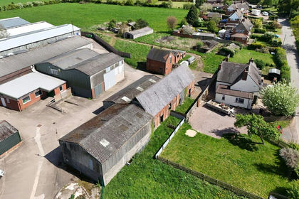
- Price
- Offers in Region of£475,000
Common Lane, Bednall, ST17, Acton Trussell and Bednall, Staffordshire ST17 England
Added on 29/01/2026Development Land
- Price
- £585,000
- Size
- 0.6 acres
Weston Road, Weston-On-Trent, Weston upon Trent, Derbyshire DE72 England
Added on 03/02/2026Building Plot