
Trevanion Road, Wadebridge, PL27
- Land size
- 4 acres
Key Features
- Strategic development opportunity with outline consent for up to 30 dwellings (outlined in blue)
- Adjoining landholding of approximately 35 acres (outlined in red) available for option or promotion (STP)
- Opportunity to secure and control a wider phased development scheme in a proven residential location
- Approximately 4 acres (consented site) with strong GDV potential
- Walking distance to Wadebridge town and Mains services available in local area
- Policy compliant scheme: 21 Open Market, 4 Shared Ownership, 5 Social Rent
Description
An excellent opportunity to acquire a consented residential development site with capacity for up to 30 dwellings, forming an ideal first phase within a wider strategic landholding. The site is predominantly level, south facing, and well positioned for efficient delivery of a high quality residential scheme. Access has been approved via the existing estate, with all other matters reserved. The proposed illustrative layout demonstrates a well-balanced scheme incorporating on-site public open space and a pedestrian footpath route, offering the ability to deliver a high-quality development within an established and proven residential location.
A key strategic advantage is the wider landholding, with approximately 35 acres of adjoining land under the same ownership. This presents a rare opportunity for a developer to secure control of a significantly larger land parcel, with potential for future phased development, subject to planning. The ability to combine a consented first phase providing a clear route towards delivery with longer term strategic land offers strong appeal to regional and national housebuilders seeking to establish or expand their presence within the North Cornwall market.
The consented scheme provides an immediate entry point, with the potential to influence and promote the wider landholding over time.
SECTION 106 OBLIGATIONS: The principal obligations include:-
· 9 affordable dwellings comprising 5 Social Rented and 4 Registered Provider Shared Ownership dwellings
· Education Contribution of £2,736 per qualifying open market dwelling
· Healthcare Contribution of £672 per open market dwelling
· Transport Contribution of £2,440 per open market dwelling
· Off Site Public Open Space Contribution of £972 per open market dwelling and £100 per affordable dwelling
· Minimum 1,700 sq m of on site public open space including amenity, natural and equipped children’s play space
· Minimum 25% of dwellings to meet M4(2) Accessible and Adaptable standards
· Minimum one affordable dwelling to meet M4(3) Wheelchair User standards
Based upon a 30 dwelling scheme comprising 21 open market and 9 affordable dwellings, the base financial contributions are approximately £144,120, assuming all 21 open market dwellings contain two or more bedrooms for the purposes of the Education Contribution. Financial contributions are subject to indexation in accordance with the Section 106 Agreement. Prospective purchasers should review the Section 106 Agreement in full and satisfy themselves as to the precise financial, affordable housing, phasing, public open space and other obligations affecting the development.
TENURE: Full freehold title is available.
LOCAL AUTHORITY: Cornwall County Council
COMMUNITY INFRASTRUCTURE LEVY: Please note that the proposed development set out in this application will be liable for a charge under the Community Infrastructure Levy (CIL) Regulations 2010 (as amended). The amount of the liability will be calculated when the related reserved matters application is determined. Further information about CIL is available at
BIODIVERSITY NET GAIN: The approved planning strategy provides for 10% Biodiversity Net Gain, including off site provision on adjoining land within the applicant's control together with ecological buffers and enhancement measures. Prospective purchasers should review the planning documentation for full details.
SERVICES: There are main utility services located in the vicinity, however prospective purchasers must verify availability for any mains services required and the costs of connection of such services, for themselves.
OUTLINE PLANNING: Outline Planning consent was granted by Cornwall Council under cover of application number PA24/07405 dated 2nd October 2026. Residential development comprising 30 dwellings (including affordable housing) and open space with all matters reserved except access.
WHAT3WORDS LOCATION: ///taken.propose.users
EASEMENTS, WAYLEAVES & RIGHTS OF WAY: The property is offered for sale, subject to and with the benefit of all matters contained in or referred to in the Property and Charges Register of the registered title together with all public or private rights of way, wayleaves, easements and other rights of way, which cross the property.
VIEWINGS: Please ring to view this property and check availability before incurring travel time/costs. FULL DETAILS OF ALL OUR PROPERTIES ARE AVAILABLE ON OUR WEBSITE
AGENT’S NOTE: Please note there is a public footpath that runs through the centre of the site, as per the highlighted plan.
Please also note that the sellers will require an estate road and service media to be brought to the southern boundary including service media with a retained unrestricted right of access.
BOUNDARIES: Any purchaser shall be deemed to have full knowledge of all boundaries and neither vendor nor the vendor’s agents will be responsible for defining the boundaries or the ownership thereof. Should any dispute arise as to the boundaries or any points on the particulars or plans or the interpretation of them, the question shall be referred to the vendor’s agent whose decision acting as experts shall be final
Disclaimer
Kivells, their clients and any joint agents give notice that they are not authorised to make or give representations or warranties in relation to the property. No responsibility is accepted for any statement within these particulars, which do not form part of any offer or contract. Areas, measurements and boundaries are approximate. Text, photographs, CGI’s and plans are for guidance only. It should not be assumed the property has all necessary planning or building consents, and Kivells have not tested any services or equipment. The property is sold subject to all matters in the Property and Charges Register, including rights of way and easements. Purchasers are deemed to know all boundaries. Nothing herein constitutes financial advice; seek your own. Use of Mortgage Genies SW Ltd. will result in a £250 + VAT referral fee to Kivells. Kivells retains copyright to all particulars and media.
Map Location
Property details
- Tenure
- Freehold
- Council Tax Band
- Ask Agent
- Date Posted
- 2026-10-28
Market Value Analysis
Compared with 180 Development Land listings in South West England (1+ acres).
Utilities & Restrictions
Utilities
- Electricity
- Ask Agent
- Water
- Private Supply
- Heating
- Ask Agent
- Broadband
- No Internet Connection
- Sewerage
- Septic Tank / Private
Rights & Restrictions
- Public Rights of Way
- Yes
- Private Rights of Way
- Yes
- Listed Property
- Ask Agent
- Restrictions
- Ask Agent
Listed status, conservation areas and planning constraints for this location are in the full report.
Property Features
- Accessibility
- Ask Agent
- Parking
- Ask Agent
- Garden
- Ask Agent
Beyond the particulars: planning activity, flood history, heritage and ground risks, checked for this exact spot.
Connectivity
Broadband
Fastest speed available at this postcode
1.8 Gbps
Gigabit full fibre
Suitable for
- 4K streaming on every screen
- Full-time home working
- Online gaming & big downloads
Mobile signal
Predicted 4G and 5G signal; indoor signal depends on building materials.
Ofcom Connected Nations postcode-level predictions. Speeds and signal are modelled, not measured, and vary between addresses and providers.
Signal is the easy part. Planning activity, flood history and protected designations here are in the full report.
Nearest Schools
Primary
- St Breock Primary School650 metresNo Ofsted rating
- Ages
- 4 to 11
- Pupils
- 203
- Type
- Academy converter
- Wadebridge Primary Academy0.9 milesOfsted: Good
- Ages
- 2 to 11
- Pupils
- 373
- Type
- Academy converter
- St Mabyn CofE School3.5 milesNo Ofsted rating
- Ages
- 2 to 11
- Pupils
- 50
- Type
- Academy converter
- Faith
- Church of England
- St Issey Church of England Primary School3.6 milesOfsted: Good
- Ages
- 2 to 11
- Pupils
- 124
- Type
- Academy converter
- Faith
- Church of England
- St Kew Academy3.8 milesNo Ofsted rating
- Ages
- 3 to 11
- Pupils
- 81
- Type
- Academy converter
Secondary
- Wadebridge School0.9 milesOfsted: Good
- Ages
- 11 to 16
- Pupils
- 1,018
- Type
- Academy converter
- Bodmin College6.6 milesOfsted: Requires improvement *
- Ages
- 11 to 18
- Pupils
- 1,236
- Type
- Academy converter
- Sir James Smith's School10 milesNo Ofsted rating
- Ages
- 11 to 16
- Pupils
- 588
- Type
- Academy converter
- Treviglas Academy11 milesOfsted: Good *
- Ages
- 11 to 18
- Pupils
- 872
- Type
- Academy sponsor led
- Newquay Tretherras12 milesNo Ofsted rating
- Ages
- 11 to 18
- Pupils
- 1,614
- Type
- Academy converter
* Latest graded judgement covers quality of education only; no overall grade was issued under the 2024-25 inspection framework.
Distances are straight-line from the advertised location. Source: the national school registers (DfE, Welsh Government, Scottish Government) and Ofsted.
Schools are just the start: sold prices nearby, planning activity and any flood history are in the full report.
Amenities
Supermarket
GP surgery
Pharmacy
Hospital
Green space
Straight-line distances from the advertised location. Sources: NHS records, Geolytix supermarket locations, OS Open Greenspace and the national trails registers.
The area stacks up? Now check the location itself: planning nearby, protected designations and past flooding.
Getting Around
Nearest station
Nearest bus stop
Typical drive times
Straight-line distances from the advertised location; drive times are typical free-flow times over OpenStreetMap road data, so allow more at peak. Public transport locations from DfT NaPTAN.
Easy to reach matters. So do planning activity, flood history and ground risks: all in the full report.
Flood Risk
Environment Agency open data, checked around the advertised map pin for the listed acreage. Long-term risk counts flood defences; the planning map's flood zones do not. Provided by LandSale, not the listing agent, and not part of the agent's particulars. Risk varies across a holding, so verify before committing.
Rivers and the sea
Planning map: Flood Zone 1.
Surface water
Not at the pin: mapped about 30 metres away.
These bandings are the summary. Where this location sits on the flood maps, plus planning activity, heritage and ground risks, is in the full report.
Important notice: Information, maps and tags on this page are drawn from the advertising agent's marketing materials or generated automatically. LandSale has not verified them. Relying on these details is at your own risk, always carry out independent checks before committing to a purchase.
LandSale full disclaimer
Marketing information only - not formal particulars. The details on this website are provided for general guidance and do not constitute an offer or contract. Neither LandSale nor the advertising estate/land agent accepts responsibility for any inaccuracy.
1. Source of information
- Listing content: Core description, asking price, tenure, measurements, photographs and planning history originate from the marketing materials of the advertising estate or land agent. LandSale does not author this content and cannot guarantee its accuracy.
- Automated tags & categorisation: Property type, land-use class, acreage bands and similar labels may be applied by machine-learning models. They are intended as a helpful guide only and may not reflect the property's legal status or permitted use.
- Third-party & enriched data layers: Maps, boundary outlines, planning designations, soil reports, broadband coverage and other environmental or location-based insights are licensed from external suppliers. Such data are supplied “as is", may be incomplete or out of date and are subject to change without notice.
2. Verification required
Prospective purchasers must verify critical matters, including but not limited to planning permission, title boundaries, public rights of way, environmental constraints, acreage, services, access and VAT status, through their own inspections, specialist surveys, legal advisers and the selling agent before relying on the information or entering into any contract.
3. No warranty or liability
LandSale gives no warranty, express or implied, as to the accuracy, completeness or fitness for any particular purpose of the information displayed. LandSale shall not be liable for any loss, damage, cost or expense arising directly or indirectly from any use of or reliance on such information, save where liability may not be excluded by law.
4. Updates & feedback
If you believe any detail on this listing is inaccurate, please let us know. We will investigate and, where appropriate, update the listing or notify the agent.
© LandSale | Version 1.3 - August 2026
Similar properties for sale
- Price
- £1,500,000
- Size
- 2.25 acres
Added on 14/03/2026Camping Land
- Price
- Guide Price£1,650,000
- Size
- 11.25 acres
Added on 29/01/2026Development Land
- Price
- £1,685,000
- Size
- 15 acres
Trenderway Farm, Pelynt, Cornwall, Pelynt, Cornwall PL13 England
Added on 29/09/2026Commercial Land
- Price
- Offers in Excess of£1,250,000
- Size
- 5.19 acres
Added on 29/01/2026Redevelopment Land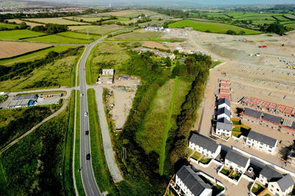
- Price
- £1,750,000
- Size
- 3.84 acres
Added on 28/01/2026Development Land- Price
- Guide Price£1,750,000
- Size
- 3.84 acres
Added on 29/01/2026Development Land