
Plot 2 Bunavullin, Drimnin, Oban, Highland, PA80
- Land size
- 0.44 acres
Key Features
- Discover a different pace of life in beautiful Drimnin, Ardnamurchan.
- Stunning coastal setting with spectacular views towards the Isle of Mull.
- Approximately 0.26 acres (1,052 sq m) of land to create your ideal home
- Full planning permission for a HebHomes LH102 dwelling.
- Immerse yourself in unspoilt nature, abundant wildlife and the tranquillity of Scotland's west coast.
- Enjoy a warm, welcoming community, exceptional scenery and a more relaxed work-life balance.
- Easy access to utilities, mains water and sewerage, with no need for a septic tank.
- Bid now! To avoid missing out
Description
Exceptional Building Plot with PLANNING PERMISSION GRANTED in stunning location in the Western Highlands offering unrivalled views across the Sound of Mull to Tobermory (sea views).
A rare opportunity to acquire an attractive building plot in Drimnin, on the Ardnamurchan Peninsula, offering an exceptional setting for those seeking a lifestyle change, a fresh start or the chance to create a bespoke home surrounded by Scotland's stunning natural landscape. Freehold land.
With full planning permission already in place, this plot offers an exciting opportunity to build in a peaceful coastal community, where dramatic scenery, abundant wildlife and a slower pace of life combine to create a truly special place to live. Highland Council 24/04792/FUL view on planning portal
Site area: Approximately 0.44 acres (1,780 sq m)- Excellent sized plot with super access.
Planning permission: Full planning permission granted for Three-bedroom, two-bathroom dwelling with an open-plan layout. Granted in November 2024.
https://wam.highland.gov.uk/wam/simpleSearchResults.do?action=firstPage
Approved design: HebHomes LH702PD
However an opportunity exists to alter the layout with the major planning hurdles cleared a realistic planning change should pose no significant difficulties.
Buyers may wish to explore amendments to the approved plans to suit their own requirements, preferred layout and budget, subject to the necessary planning approvals.
Drimnin offers a unique combination of spectacular scenery, tranquillity and a welcoming local community. With views across the water towards the Isle of Mull, the location is ideal for those looking to enjoy a more relaxed lifestyle in an unspoilt part of Scotland. The plot offers a truely outstanding costal setting in one of Scotland's most beautiful locations.
The surrounding area is rich in wildlife, with sea eagles, golden eagles, peregrine falcons, pine martins, otters and red squirrels found locally. Wildcats are also present in the wider region, while dolphins and whales are often spotted in the surrounding waters.
Access is granted from the plot to the foreshore.
Whether you are planning a permanent home, a remote-working lifestyle or a self-build project in a remarkable coastal location, this plot offers plenty of potential. This site provides easy access to utilities with mains water and sewerage closeby.
The village, surprisingly, offers some of the fastest internet speeds in Scotland- thanks to the Drimnin Community Broadband Network.
Drimnin is located on the mainland with Morven. Morven is the southern most of the West Highland Peninsulas.and is accessible via the Corran Ferry and the scenic route through the Ardtornish Estate area. Ferry connections in the wider region include services between Lochaline and the Isle of Mull, with additional routes serving Oban.
Morvern is approximately 200 square miles, its varied habitats include ancient woodlands, rolling hills, rivers and sea lochs as well as 20 miles of coastline. The Morvern Peninsula is separated from the Isle of Mull by a narrow strip of water called the Sound of Mull. It is one of the few places in the UK that has hardly been touched by modern life. It is sparsely populated, and because of a lack of human intervention, it boasts a great diversity of animals, birds and flowers.
Described by many as 'the best kept secret in Scotland', Morvern is a must for nature lovers seeking solitude and rare species of wildlife. In winter there is a wide range of wildlife from Sea Eagles and Golden Eagles to Pine Martins and Peregrines. It's also home to one of the UK's most elusive creatures - the Otter.
The main settlement in Morvern is Lochaline, where you will find a village store and post office, cafe and restaurant and fuel. Lochaline also serves as a ferry terminal to Fishnish on the Isle of Mull.
Morvern is a great place to immerse yourself in the beauty of this wild, remote landscape. It is a place to enjoy some wildlife and lovely walks on the mainland, as well as being within easy reach of the Isle of Mull.
An opportunity not to miss, With its generous site area, full planning permission and spectacular coastal surroundings, Plot 1 presents an appealing opportunity to create a home tailored to your lifestyle.
This lot will be sold under auction terms and conditions by Braveheart Auctions.
Speak to one of our dedicated team today for more information or submit offer now.
Be Brave...Follow Your Heart
Braveheart Auctions hold land and property auctions every 2 weeks.
Do you know someone with a problem property?
Pass the details to Braveheart Auctions- We will sell it and we will pay you for the referral. Or speak to us about a FREE auction valuation.
Map Location
Property details
- Tenure
- Ask Agent
- Council Tax Band
- Ask Agent
- Date Posted
- 2026-10-23
Utilities & Restrictions
Utilities
- Electricity
- Ask Agent
- Water
- Ask Agent
- Heating
- Ask Agent
- Broadband
- Ask Agent
- Sewerage
- Ask Agent
Rights & Restrictions
- Public Rights of Way
- Ask Agent
- Private Rights of Way
- Ask Agent
- Listed Property
- Ask Agent
- Restrictions
- Ask Agent
Listed status, conservation areas and planning constraints for this location are in the full report.
Property Features
- Accessibility
- Ask Agent
- Parking
- Ask Agent
- Garden
- Ask Agent
Beyond the particulars: planning activity, flood history, heritage and ground risks, checked for this exact spot.
Connectivity
Broadband
Fastest speed available at this postcode
1 Mbps
Under 10 Mbps here
Suitable for
- Basic browsing & email
Mobile signal
Predicted 4G and 5G signal; indoor signal depends on building materials.
Ofcom Connected Nations postcode-level predictions. Speeds and signal are modelled, not measured, and vary between addresses and providers.
Signal is the easy part. Planning activity, flood history and protected designations here are in the full report.
Nearest Schools
Primary
- Tobermory High School4.1 miles
- Pupils
- 73
- Type
- Non-denominational
- Salen Primary School5.6 miles
- Pupils
- 32
- Type
- Non-denominational
- Salen Primary Gaelic Unit5.6 miles
- Pupils
- 32
- Type
- Non-denominational
- Dervaig Primary School8.2 miles
- Pupils
- 15
- Type
- Non-denominational
- Lochaline Primary School8.4 miles
- Pupils
- 9
- Type
- Non-denominational
Secondary
- Tobermory High School4.1 miles
- Pupils
- 151
- Type
- Non-denominational
- Ardnamurchan High School17 miles
- Pupils
- 126
- Type
- Non-denominational
- Oban High School23 miles
- Pupils
- 1,009
- Type
- Non-denominational
- Mallaig High School28 miles
- Pupils
- 101
- Type
- Non-denominational
- Tiree High School37 miles
- Pupils
- 37
- Type
- Non-denominational
Distances are straight-line from the advertised location. Source: the national school registers (DfE, Welsh Government, Scottish Government) and Ofsted.
Schools are just the start: planning activity, heritage and any flood history here are in the full report.
Amenities
Supermarket
GP surgery
Pharmacy
Walking trail
Straight-line distances from the advertised location. Sources: NHS records, Geolytix supermarket locations, OS Open Greenspace and the national trails registers.
The area stacks up? Now check the location itself: planning nearby, protected designations and past flooding.
Getting Around
Nearest station
Nearest bus stop
Typical drive times
Straight-line distances from the advertised location; drive times are typical free-flow times over OpenStreetMap road data, so allow more at peak. Public transport locations from DfT NaPTAN.
Easy to reach matters. So do planning activity, flood history and ground risks: all in the full report.
Flood Risk
SEPA open data, checked around the advertised map pin for the listed acreage. Provided by LandSale, not the listing agent, and not part of the agent's particulars. Risk varies across a holding, so verify before committing.
Rivers and the sea
Surface water
Not at the pin: mapped about 10 metres away.
These bandings are the summary. Where this location sits on the flood maps, plus planning activity, heritage and ground risks, is in the full report.
Important notice: Information, maps and tags on this page are drawn from the advertising agent's marketing materials or generated automatically. LandSale has not verified them. Relying on these details is at your own risk, always carry out independent checks before committing to a purchase.
LandSale full disclaimer
Marketing information only - not formal particulars. The details on this website are provided for general guidance and do not constitute an offer or contract. Neither LandSale nor the advertising estate/land agent accepts responsibility for any inaccuracy.
1. Source of information
- Listing content: Core description, asking price, tenure, measurements, photographs and planning history originate from the marketing materials of the advertising estate or land agent. LandSale does not author this content and cannot guarantee its accuracy.
- Automated tags & categorisation: Property type, land-use class, acreage bands and similar labels may be applied by machine-learning models. They are intended as a helpful guide only and may not reflect the property's legal status or permitted use.
- Third-party & enriched data layers: Maps, boundary outlines, planning designations, soil reports, broadband coverage and other environmental or location-based insights are licensed from external suppliers. Such data are supplied “as is", may be incomplete or out of date and are subject to change without notice.
2. Verification required
Prospective purchasers must verify critical matters, including but not limited to planning permission, title boundaries, public rights of way, environmental constraints, acreage, services, access and VAT status, through their own inspections, specialist surveys, legal advisers and the selling agent before relying on the information or entering into any contract.
3. No warranty or liability
LandSale gives no warranty, express or implied, as to the accuracy, completeness or fitness for any particular purpose of the information displayed. LandSale shall not be liable for any loss, damage, cost or expense arising directly or indirectly from any use of or reliance on such information, save where liability may not be excluded by law.
4. Updates & feedback
If you believe any detail on this listing is inaccurate, please let us know. We will investigate and, where appropriate, update the listing or notify the agent.
© LandSale | Version 1.3 - August 2026
Listing agent
Braveheart Auctions Limited, Edinburgh5 South Charlotte Street, Edinburgh, Scotland, EH2 4AN
Contact Braveheart Auctions Limited, Edinburgh
5 South Charlotte Street, Edinburgh, Scotland, EH2 4AN
View agent profileSimilar properties for sale
- Price
- Guide Price£90,000
- Size
- 0.36 acres
Added on 29/01/2026Building Plot
- Price
- Guide Price£85,000
- Size
- 0.6 acres
Added on 30/05/2026Building Plot
- Price
- Offers Over£75,000
- Size
- 0.4 acres
Added on 14/10/2026Building Plot
- Price
- Guide Price£85,000
- Size
- 0.66 acres
Added on 29/01/2026Building Plot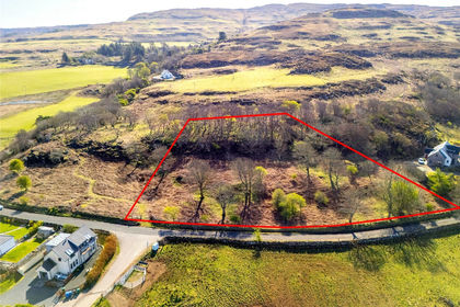
- Price
- Offers Over£80,000
- Size
- 0.62 acres
Development Plots (Plot 3), Calgary, Isle Of Mull, PA75, Isle Of Mull, Argyll and Bute PA75 Scotland
Added on 29/01/2026Building Plot- Price
- Offers Over£90,000
- Size
- 0.67 acres
Development Plots (Plot 2), Calgary, Isle Of Mull, PA75, Isle Of Mull, Argyll and Bute PA75 Scotland
Added on 29/01/2026Building Plot
- Price
- Guide Price£55,000
- Size
- 0.11 acres
Added on 29/01/2026Building Plot
- Price
- Guide Price£89,000
- Size
- 1.2 acres
Added on 29/01/2026Building Plot- Price
- Guide Price£79,000
- Size
- 0.6 acres
Added on 29/01/2026Building Plot