Raggithill, Mossblown, Ayr, KA6
- Land size
- 10 acres
Key Features
- Successful kennel business
- Charming 5 bedroom farmhouse with generous and flexible accommodation
- Strategic location, close to Prestwick Airport
- Panoramic views over the surrounding countryside towards the Firth of Clyde
Description
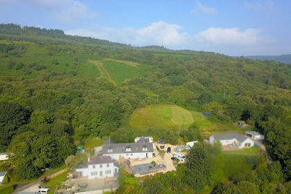
Raggithill property comprises of an established and highly successful kennel business, detached farmhouse (council tax band F) , several outbuildings, industrial greenhouses and a field extending to approximately 10 acres with panoramic views across the Firth of Clyde. Business accounts are available to parties who note interest through their solicitor and can provide proof of funding for a purchase. Raggithill Kennels are purpose built, fully secure and heated kennel facilities which have an excellent reputation with a high level of repeat business. The property may have further commercial potential in the existing buildings, subject to obtaining the necessary consents.
The farmhouse itself provides generous and flexible accommodation over two levels. Of particular note are the views to the North West over the rolling fields and across the Firth towards Arran which can be seen on a clear day. The property predominantly faces south with a peaceful and private outlook. The gardens, to three sides are predominantly laid to lawn with some herbaceous shrubs and planting. The gardens to the West include a useful outbuilding for garden storage.
Services: Water Mains supply, Drainage Septic Tank (2), Heating Biomass boiler
Location
Raggithill sits in an elevated position above the North-Western edge of Mossblown, in rural surroundings with sublime views West, to the Forth of Clyde and Arran, and South across the county. Mossblown is a short distance from Ayr and has ease of access to Kilmarnock and Glasgow via the A77 & M77. Mossblown has a medical practice, pharmacy, grocery store, take-aways, post office, activity centre, hairdresser and a popular Public House with a restaurant. Two bus routes serve the village, connecting Mossblown with Ayr to the south, Annbank to the east and Tarbolton and New Cumnock to the North. Times vary accordingly but generally two buses per hour allow villagers to commute to Ayr, with its proximity of five miles (eight kilometres) giving villagers access to high street retailers. Prestwick, some 5 miles to the east has a comprehensive range of amenities, including schools, restaurants and bars, transport links to Glasgow and beyond, shops, supermarkets and leisure facilities. Mossblown has a primary school and thriving private day nursery. The school has in recent years been extended to include the village library and sports facilities for the school. Annbank and Mossblown are in the catchment area for Ayr Academy.
A vehicular and pedestrian right of access is granted over the access road to Raggithill, a maintenance obligation applies on a user basis. The subjects are sold together with and subject to all existing rights of way, servitudes, wayleaves and others whether contained in the Title Deeds or otherwise, and purchasers will be deemed to have satisfied themselves in all respects thereof.
The Land
The Field to the West of the property has been used for grazing or dog walking historically. The land is in good order with secure perimeter boundary fencing throughout. Vehicular access is only via Raggithill Farm. The James Hutton Institute classify the land as 3.2 , general soil type of mineral gleys. The land predominantly slopes to the north and undulates to the south.
The Outbuildings
The outbuildings sit in a courtyard formation to the rear of the dwelling house. The serviced kennel building (22.60m x 14.99m) is detached with concrete foundations, brick and steel construction under a metal roof. In addition there is a further kennel block (13.90m x 5.89m) with a concrete floor and timber and brick construction. A further outbuilding of the same construction, sits adjacent and has been used in the past for storage facilities (9.78m x 7.06m) with an adjoining garage (9.80m x 6.58m). To the rear of the courtyard there is a significant commercial greenhouse which has not been in operation for some years and now requires repair.
Map Location
Property details
- Tenure
- Freehold
- Council Tax Band
- Ask Agent
- Date Posted
- 2026-10-22
Market Value Analysis
Compared with 3 Kennels listings in Scotland (1+ acres).
Utilities & Restrictions
Utilities
- Electricity
- Ask Agent
- Water
- Ask Agent
- Heating
- Ask Agent
- Broadband
- Ask Agent
- Sewerage
- Ask Agent
Rights & Restrictions
- Public Rights of Way
- Ask Agent
- Private Rights of Way
- Ask Agent
- Listed Property
- Ask Agent
- Restrictions
- Ask Agent
Listed status, conservation areas and planning constraints for this location are in the full report.
Property Features
- Accessibility
- Ask Agent
- Parking
- Ask Agent
- Garden
- Ask Agent
Beyond the particulars: planning activity, flood history, heritage and ground risks, checked for this exact spot.
Connectivity
Broadband
Fastest speed available at this postcode
1.8 Gbps
Gigabit full fibre
Suitable for
- 4K streaming on every screen
- Full-time home working
- Online gaming & big downloads
Mobile signal
Predicted 4G and 5G signal; indoor signal depends on building materials.
Ofcom Connected Nations postcode-level predictions. Speeds and signal are modelled, not measured, and vary between addresses and providers.
Signal is the easy part. Planning activity, flood history and protected designations here are in the full report.
Nearest Schools
Primary
- Annbank Primary School0.7 miles
- Pupils
- 265
- Type
- Non-denominational
- Glenburn Primary School2.3 miles
- Pupils
- 287
- Type
- Non-denominational
- St Ninian's Primary School2.3 miles
- Pupils
- 129
- Type
- Roman Catholic
- Tarbolton Primary School2.3 miles
- Pupils
- 205
- Type
- Non-denominational
- Dalmilling Primary School2.7 miles
- Pupils
- 329
- Type
- Non-denominational
Secondary
- Prestwick Academy2.6 miles
- Pupils
- 1,186
- Type
- Non-denominational
- Kyle Academy3.5 miles
- Pupils
- 821
- Type
- Non-denominational
- Ayr Academy3.7 miles
- Pupils
- 602
- Type
- Non-denominational
- Queen Margaret Academy4.4 miles
- Pupils
- 681
- Type
- Roman Catholic
- South Ayrshire Council Virtual School4.5 miles
- Type
- Non-denominational
Distances are straight-line from the advertised location. Source: the national school registers (DfE, Welsh Government, Scottish Government) and Ofsted.
Schools are just the start: planning activity, heritage and any flood history here are in the full report.
Amenities
Supermarket
GP surgery
Pharmacy
Green space
Straight-line distances from the advertised location. Sources: NHS records, Geolytix supermarket locations, OS Open Greenspace and the national trails registers.
The area stacks up? Now check the location itself: planning nearby, protected designations and past flooding.
Getting Around
Nearest station
Nearest bus stop
Typical drive times
Straight-line distances from the advertised location; drive times are typical free-flow times over OpenStreetMap road data, so allow more at peak. Public transport locations from DfT NaPTAN.
Easy to reach matters. So do planning activity, flood history and ground risks: all in the full report.
Flood Risk
SEPA open data, checked around the advertised map pin for the listed acreage. Provided by LandSale, not the listing agent, and not part of the agent's particulars. Risk varies across a holding, so verify before committing.
Rivers and the sea
Surface water
Not at the pin: mapped about 30 metres away.
These bandings are the summary. Where this location sits on the flood maps, plus planning activity, heritage and ground risks, is in the full report.
Important notice: Information, maps and tags on this page are drawn from the advertising agent's marketing materials or generated automatically. LandSale has not verified them. Relying on these details is at your own risk, always carry out independent checks before committing to a purchase.
LandSale full disclaimer
Marketing information only - not formal particulars. The details on this website are provided for general guidance and do not constitute an offer or contract. Neither LandSale nor the advertising estate/land agent accepts responsibility for any inaccuracy.
1. Source of information
- Listing content: Core description, asking price, tenure, measurements, photographs and planning history originate from the marketing materials of the advertising estate or land agent. LandSale does not author this content and cannot guarantee its accuracy.
- Automated tags & categorisation: Property type, land-use class, acreage bands and similar labels may be applied by machine-learning models. They are intended as a helpful guide only and may not reflect the property's legal status or permitted use.
- Third-party & enriched data layers: Maps, boundary outlines, planning designations, soil reports, broadband coverage and other environmental or location-based insights are licensed from external suppliers. Such data are supplied “as is", may be incomplete or out of date and are subject to change without notice.
2. Verification required
Prospective purchasers must verify critical matters, including but not limited to planning permission, title boundaries, public rights of way, environmental constraints, acreage, services, access and VAT status, through their own inspections, specialist surveys, legal advisers and the selling agent before relying on the information or entering into any contract.
3. No warranty or liability
LandSale gives no warranty, express or implied, as to the accuracy, completeness or fitness for any particular purpose of the information displayed. LandSale shall not be liable for any loss, damage, cost or expense arising directly or indirectly from any use of or reliance on such information, save where liability may not be excluded by law.
4. Updates & feedback
If you believe any detail on this listing is inaccurate, please let us know. We will investigate and, where appropriate, update the listing or notify the agent.
© LandSale | Version 1.3 - August 2026
Listing agent
DM Hall LLP, Bridge of AllanContact DM Hall LLP, Bridge of Allan
View agent profileSimilar properties for sale
- Price
- £600,000
- Size
- 26 acres
Added on 25/09/2026Smallholding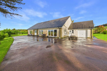
- Price
- Offers Over£580,000
- Size
- 13 acres
Auchenheath, Lanark, ML11, Hamilton and Clyde Valley, South Lanarkshire ML11 Scotland
Added on 20/10/2026Smallholding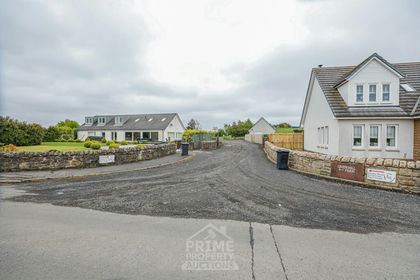
- Price
- £950,000
- Size
- 28 acres
Greenhill Farm, Hareshaw, ML1, Airdrie and Shotts, North Lanarkshire ML1 Scotland
Added on 17/07/2026Commercial Land
- Price
- Guide Price£900,000
- Size
- 28 acres
Greenhill Farm, Hareshaw, ML1, Airdrie and Shotts, North Lanarkshire ML1 Scotland
Added on 26/05/2026Farm
- Price
- Offers Over£795,000
- Size
- 176.6 acres
Glenquicken House, Newton Stewart DG8, Dumfries and Galloway, Dumfries and Galloway DG8 Scotland
Added on 21/07/2026Farm
- Price
- Offers in Excess of£640,000
- Size
- 259.61 acres
Land at Darrach Hill, By Carron Valley, Denny, FK6, Stirling and Strathallan, Stirling FK6 Scotland
Added on 11/05/2026Farmland
- Price
- Offers in Excess of£595,000
- Size
- 16.61 acres
Nunland, Lochfoot, Dumfries, DG2, Dumfries and Galloway, Dumfries and Galloway DG2 Scotland
Added on 29/01/2026Cottage
- Price
- Offers Over£495,000
- Size
- 4.5 acres
Added on 03/07/2026Smallholding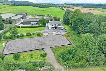
- Price
- Offers Over£630,000
- Size
- 14.58 acres
Mains of Twynholm, Twynholm, DG6, Dumfries and Galloway, Dumfries and Galloway DG6 Scotland
Added on 02/05/2026Smallholding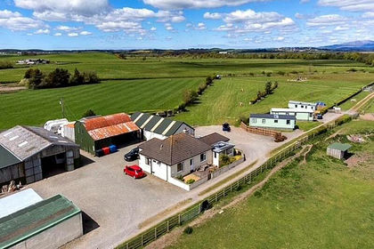
- Price
- Offers in Excess of£625,000
- Size
- 12.44 acres
Added on 22/10/2026Camping Land