
Building Plot At Trearddur House, Trearddur Court, Trearddur Bay, Holyhead, LL65
- Land size
- 0.38 acres
- Dwelling size
- 2981 sqft
Description
AN EXCITING AND RARE OPPORTUNITY TO ACQUIRE AN INDIVIDUAL BUILDING PLOT WITH PLANNING PERMISSION FOR A DETACHED 4 BED HOUSE OCCUPYING AN ELEVATED POSITION WITH SPECTACULAR SEA VIEWS.
PROPOSED ACCOMMODATION
Entrance Hall; Open plan Kitchen with breakfast area and dedicated dining area; Lounge; Study; Utility; Separate W.C.; Double Garage/Boat Store; 4 Double Bedrooms; 3 Bath/Shower Rooms; Lawned and Terraced Gardens; Parking. In all about 0.38 of an acre.
DESCRIPTION
On 19th December 2019 the application for a certificate of proposed use or development in relation to a material start having been made on planning permission 46C168A/FR and reserved matters application 46C168D/DA thus safeguarding the consent for the erection of a dwelling on land at Trearddur House, Trearddur Bay was approved. The permission provides for an impressive, two storey detached dwelling which will provide spacious and well proportioned accommodation ideally suited for either permanent occupancy or use as a second home. Indeed, there is no occupancy condition imposed, which is now a rare attribute based on current planning policy. The architect’s design responds to the superb location and orientation, with the principal living accommodation and all bedrooms arranged to enjoy an open southerly aspect across the bay, the main beach and the Snowdonia mountain range and the Llyn peninsula beyond.
LOCATION
The building plot occupies an elevated position in Trearddur Bay, accessed off Trearddur Court via a private drive also serving the adjacent Trearddur House. The immediate position of the plot is of particular significance as it has lovely views across the village and playing field, and out to sea, yet is only a short distance from the beaches in Trearddur. The village provides local services including a Spar, Post Office and restaurants notably the Seacroft, Sea Shanty and Oceans Edge.
Holyhead is 3 miles distant with a retail park including several supermarkets and department stores. On the recreational front the island is known for its scenic coastline with numerous sandy beaches. There is excellent walking both inland and along the Anglesey Coastal Path. There is a marina at Holyhead and several golf courses within close proximity. There is also excellent wind surfing and kitesurfing at nearby Rhosneigr and Newborough.
COMMUNICATIONS
The property benefits from good road communications being within 2 miles of the A55 expressway facilitating easy access across Anglesey and the North Wales coast to Cheshire and linking with the national motorway network. For travel further afield there is a direct rail service from Holyhead to London Euston and a daily ferry service to Dun Laoghaire.
DIRECTIONS
To reach the property from Holyhead proceed towards the village and having passed Trearddur Road on the left take the next turn right into Trearddur Court. Follow to the T-junction where the entrance for the plot and the neighbouring property, Trearddur House, will be seen on the left hand side. Having driven through the entrance, the drive to the plot is directly ahead.
PROPERTY INFORMATION
Address: Building plot at Trearddur House, Trearddur Court, Trearddur Bay, Anglesey, LL65 2UD.
Tenure: Freehold with vacant possession
Services: Mains water and gas to the site. The property will need to connect to a private sewage treatment plant, the permit for which has been secured by the vendors from Natural Resources Wales and is transferable to the purchaser.
Local Authority: Ynys Mon Council Tel: 01248 750057
NB: The red lines and pink site plan incorporated on the accompanying images are indicative of the proposed boundaries. Pegs indicating the boundaries are on site.
Map Location
Property details
- Tenure
- Freehold
- Council Tax Band
- Ask Agent
- Date Posted
- 2026-10-21
Property Brochure
Seen the details? The full report adds the independent checks: planning activity, flood history, heritage and ground.
Utilities & Restrictions
Utilities
- Electricity
- Ask Agent
- Water
- Ask Agent
- Heating
- Ask Agent
- Broadband
- Ask Agent
- Sewerage
- Ask Agent
Rights & Restrictions
- Public Rights of Way
- Ask Agent
- Private Rights of Way
- Ask Agent
- Listed Property
- Ask Agent
- Restrictions
- Ask Agent
Listed status, conservation areas and planning constraints for this location are in the full report.
Property Features
- Accessibility
- Ask Agent
- Parking
- Ask Agent
- Garden
- Ask Agent
Beyond the particulars: planning activity, flood history, heritage and ground risks, checked for this exact spot.
Connectivity
Broadband
Fastest speed available at this postcode
1.8 Gbps
Superfast
Suitable for
- 4K streaming on every screen
- Full-time home working
- Online gaming & big downloads
Mobile signal
Predicted 4G and 5G signal; indoor signal depends on building materials.
Ofcom Connected Nations postcode-level predictions. Speeds and signal are modelled, not measured, and vary between addresses and providers.
Signal is the easy part. Planning activity, flood history and protected designations here are in the full report.
Nearest Schools
Primary
- Ysgol Gynradd Kingsland1.3 miles
- Pupils
- 166
- Type
- Nursery, Infants & Juniors
- Language
- Welsh medium school / provision (including transitional)
- Ysgol Gymraeg Morswyn1.3 miles
- Pupils
- 178
- Type
- Nursery, Infants & Juniors
- Language
- Welsh medium school / provision (including transitional)
- Ysgol Santes Gwenfaen1.4 miles
- Pupils
- 106
- Type
- Nursery, Infants & Juniors
- Language
- Welsh medium school / provision (including transitional)
- Ysgol Llanfawr1.8 miles
- Pupils
- 256
- Type
- Nursery, Infants & Juniors
- Language
- Welsh medium school / provision (including transitional)
- Ysgol Santes Fair1.9 miles
- Pupils
- 99
- Type
- Nursery, Infants & Juniors
- Language
- Welsh medium school / provision (including transitional)
Secondary
- Ysgol Uwchradd Caergybi2.2 miles
- Pupils
- 818
- Type
- Secondary (ages 11-19)
- Language
- Welsh medium school / provision (including transitional)
- Ysgol Uwchradd Bodedern4.7 miles
- Pupils
- 810
- Type
- Secondary (ages 11-19)
- Language
- Welsh medium school / provision (including transitional)
- Ysgol Gyfun Llangefni12 miles
- Pupils
- 761
- Type
- Secondary (ages 11-19)
- Language
- Welsh medium school / provision (including transitional)
- Ysgol Syr Thomas Jones14 miles
- Pupils
- 537
- Type
- Secondary (ages 11-19)
- Language
- Welsh medium school / provision (including transitional)
- Ysgol Syr Hugh Owen17 miles
- Pupils
- 873
- Type
- Secondary (ages 11-19)
- Language
- Welsh medium school / provision (including transitional)
Distances are straight-line from the advertised location. Source: the national school registers (DfE, Welsh Government, Scottish Government) and Ofsted.
Schools are just the start: sold prices nearby, planning activity and any flood history are in the full report.
Amenities
Supermarket
GP surgery
Pharmacy
Green space
Straight-line distances from the advertised location. Sources: NHS records, Geolytix supermarket locations, OS Open Greenspace and the national trails registers.
The area stacks up? Now check the location itself: planning nearby, protected designations and past flooding.
Getting Around
Nearest station
Nearest bus stop
Typical drive times
Straight-line distances from the advertised location; drive times are typical free-flow times over OpenStreetMap road data, so allow more at peak. Public transport locations from DfT NaPTAN.
Easy to reach matters. So do planning activity, flood history and ground risks: all in the full report.
Flood Risk
Natural Resources Wales open data, checked around the advertised map pin for the listed acreage. Long-term risk counts flood defences; the planning map's flood zones do not. Provided by LandSale, not the listing agent, and not part of the agent's particulars. Risk varies across a holding, so verify before committing.
Rivers and the sea
Planning map: Flood Zone 1.
Surface water
These bandings are the summary. Where this location sits on the flood maps, plus planning activity, heritage and ground risks, is in the full report.
Important notice: Information, maps and tags on this page are drawn from the advertising agent's marketing materials or generated automatically. LandSale has not verified them. Relying on these details is at your own risk, always carry out independent checks before committing to a purchase.
LandSale full disclaimer
Marketing information only - not formal particulars. The details on this website are provided for general guidance and do not constitute an offer or contract. Neither LandSale nor the advertising estate/land agent accepts responsibility for any inaccuracy.
1. Source of information
- Listing content: Core description, asking price, tenure, measurements, photographs and planning history originate from the marketing materials of the advertising estate or land agent. LandSale does not author this content and cannot guarantee its accuracy.
- Automated tags & categorisation: Property type, land-use class, acreage bands and similar labels may be applied by machine-learning models. They are intended as a helpful guide only and may not reflect the property's legal status or permitted use.
- Third-party & enriched data layers: Maps, boundary outlines, planning designations, soil reports, broadband coverage and other environmental or location-based insights are licensed from external suppliers. Such data are supplied “as is", may be incomplete or out of date and are subject to change without notice.
2. Verification required
Prospective purchasers must verify critical matters, including but not limited to planning permission, title boundaries, public rights of way, environmental constraints, acreage, services, access and VAT status, through their own inspections, specialist surveys, legal advisers and the selling agent before relying on the information or entering into any contract.
3. No warranty or liability
LandSale gives no warranty, express or implied, as to the accuracy, completeness or fitness for any particular purpose of the information displayed. LandSale shall not be liable for any loss, damage, cost or expense arising directly or indirectly from any use of or reliance on such information, save where liability may not be excluded by law.
4. Updates & feedback
If you believe any detail on this listing is inaccurate, please let us know. We will investigate and, where appropriate, update the listing or notify the agent.
© LandSale | Version 1.3 - August 2026
Similar properties for sale
 Added on 29/01/2026Development Land
- Price
- Guide Price£360,000
- Size
- 20.48 acres
Added on 06/06/2026Smallholding
- Price
- £425,000
- Size
- 2.9 acres
Penybonc Road, Penybonc, Amlwch, LL68, Amlwch, Isle of Anglesey LL68 Wales
Added on 29/01/2026Development Land Added on 16/10/2026Development Land
- Price
- Guide Price£275,000
- Size
- 0.48 acres
Land at, Cyttir Lane, Bangor, Gwynedd, LL57, Bangor, Gwynedd LL57 Wales
Added on 18/06/2026Development Land
- Price
- Offers in Region of£425,000
- Size
- 0.24 acres
Station Road, Bangor, Gwynedd, LL57, Bangor, Gwynedd LL57 Wales
Added on 29/01/2026Warehouse
- Price
- £375,000
- Size
- 0.28 acres
Deiniol Road, Bangor, Gwynedd, LL57, Bangor, Gwynedd LL57 Wales
Added on 29/01/2026Undeveloped Land
- Price
- £295,000
- Size
- 12 acres
Added on 22/06/2026Agricultural Land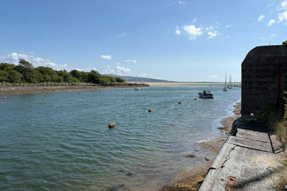 Added on 08/08/2026Development Land