Auction: Wednesday 28 October 2026 at 9am
Development Land For Sale At Heathervale Walk, Armadale, Bathgate, West Lothian, EH48
Key Features
- EXCELLENT OPPORTUNITY TO ACQUIRE A DEVELOPMENT SITE
- SITUATED WITHIN THE POPULAR WEST LOTHIAN TOWN OF ARMADALE
- OFFERS POTENTIAL FOR A RANGE OF USES INCLUDING A SINGLE DWELLING HOUSE, OR GARAGES / STORAGE FACILITIES (SUBJECT TO NECESSARY CONSENTS)
Description
FOR SALE BY ONLINE AUCTION ON WEDNESDAY 28TH OCTOBER 2026 AT 9AM - ***EXCELLENT OPPORTUNITY TO ACQUIRE A DEVELOPMENT SITE***SITUATED WITHIN THE POPULAR WEST LOTHIAN TOWN OF ARMADALE***OFFERS POTENTIAL FOR A RANGE OF DEVELOPMENT OR ALTERNATIVE USES INCLUDING A SINGLE DWELLING HOUSE, OR GARAGES / STORAGE FACILITIES (SUBJECT TO NECESSARY CONSENTS)***
The site offers potential for a range of development or alternative uses, subject to obtaining all necessary planning permissions and consents. The property may therefore appeal to developers, builders, investors and private purchasers seeking a site with future potential in an established residential location.
Size: 585.83sqm
Armadale is a well-connected town situated between Bathgate and West Calder, offering a range of local amenities including shops, supermarkets, schools, leisure facilities, cafs and public services. The surrounding area provides access to attractive countryside and recreational opportunities, while nearby Polkemmet Country Park provides extensive woodland, open space and walking routes.
The location also benefits from excellent transport connections. Armadale railway station provides regular services towards Edinburgh and Glasgow, while the nearby M8 motorway provides convenient access to West Lothian, Edinburgh, Glasgow and the wider central belt.
Heathervale Walk represents an appealing development opportunity in an established West Lothian location, with potential for purchasers to explore a variety of future uses, subject to planning.
***DESCRIPTION***
*LAND*
The site is located within the town of Armadale, West Lothian. Armadale benefits from excellent transport links to the M8 motorway providing easier access to Glasgow (27 miles) and Edinburgh (20 miles). Edinburgh and Glasgow airports are within one hour's drive of the town whilst Bathgate benefits from a train station with a regular service to many of Scotland's main stations.
*THE SITE*
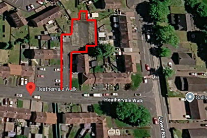
The subjects comprise of a gap site within a residential housing estate with potential for residential development. The lock up garages on sites are vacant and not
subject to any current tenancy agreements. Applicants should consider the extend of the existing highways and footpaths when considering a development scheme. Any enquires relating to the public highway should be directed to the Council's Roads and Transportation department.
***RECENT NEARBY RESIDENTIAL PROPERTY SALES***
- 22, Heathervale Walk, Bathville, Bathgate, EH48 2LL, Terraced, 3 bedroom, SOLD DEC'25 - £165,000
- 216, Leyland Road, Bathgate, EH48 2TS, Flat, 2 bedroom, SOLD JUL'26 - £142,000
- 26, Cricketfield Place, Armadale, EH48 2GB, Terraced, 2 bedroom, SOLD JUL'26 - £166,500
Armadale is a town within the county of West Lothian in the Central Belt of Scotland. It lies to the west of Bathgate and to the east of Blackridge. Armadale, formerly known as Barbauchlaw, is an ex-mining town which was also known for its brick manufacturing. It is named after Armadale in Sutherland, this estate being owned by Sir William Honeyman who later acquired the land of Barbauchlaw. Primarily a residential community, the town has a number of different public places, a central Mains Street and a series of parks, green spaces and nature reserves, many of which lie atop former mines and industrial areas.
***TRANSPORT***
In 2011, rail services returned to Armadale with the opening of Armadale railway station constructed as part of the new Airdrie-Bathgate Rail Link. Located at the south end of Armadale it re-opened on 4 March 2011.
McGill's Scotland East and Lothian Country Buses also run bus services into the village linking Armadale with Blackridge, Whitburn, Bathgate, Livingston, Broxburn and Edinburgh.
A shared cycle and pedestrian path along the B8084 road was completed in 2021 following an investment of £1.2 million, providing an off-road cycle route and enabling pedestrian access to Whitburn
***EDUCATION***
The local high school Armadale Academy was originally built at the site that now plays host to Armadale Primary School. It was rebuilt and opened in 1967, at West Main Street, Armadale. It was again rebuilt and opened in August 2009, immediately behind the 1967 Academy building. The site of the old building now serves as car parking facilities, and new playing fields.
There are four primary schools in Armadale: Armadale primary school, St Anthony's RC primary school, Eastertoun primary school and the newer Southdale primary school. Armadale primary school occupies the former Academy building.
***THINGS TO DO IN ARMADALE, WEST LOTHIAN***
Armadale is a small town in West Lothian with a strong industrial heritage and good access to countryside, parks and attractions across the surrounding area. There are plenty of opportunities for walking, outdoor recreation, local history and family days out.
- Armadale Community Museum Discover the town's farming, mining and industrial heritage through a collection of local historical objects.
- Armadale Medal Route Three walking routes of varying lengths pass through the town, parks, nature areas and surrounding countryside. The longest route is approximately 3 miles.
- Black Moss Nature Park A pleasant local area for walking and enjoying woodland, ponds and wildlife.
- Polkemmet Country Park A 169-acre country park close to Armadale, offering woodland, open countryside and opportunities for walking and outdoor recreation.
- Scottish Owl Centre Located within Polkemmet Country Park, providing a family-friendly opportunity to see a variety of owls and other birds.
- Volunteer Park A local green space providing an easily accessible place for recreation and relaxation.
- Edinburgh Monarchs Speedway Armadale has a long association with motorcycle speedway, with racing taking place at Armadale Stadium during the season.
- Bridgecastle Golf Club The local nine-hole golf course provides an option for golfers within the town.
- Mill Garden Centre A popular local garden centre offering plants, gardening supplies and a range of other products.
- Watson Park and Nelson Park Local parks providing additional green space for residents and families.
- Hardhill Wood Woodland walks with views towards the Bathgate Hills.
- Cairnpapple Hill A notable prehistoric hilltop site near Torphichen, offering countryside views and an opportunity to explore West Lothian's ancient heritage.
- Nearby Linlithgow and Livingston Both are within easy reach for a wider selection of shopping, historic attractions, leisure facilities and restaurants.
Armadale also hosts its annual Gala Day, while the town centre provides pubs, cafs, restaurants and local shops for everyday leisure and socialising.
GUIDE PRICE - £29,000
To view legal documents for all properties, and to register for our online auctions please visit our website.
Purchases are subject to a Buyer's Premium. There may also be additional fees on certain properties. Please refer to the Articles of Roup/Special Conditions in the Legal pack to confirm. All prices quoted are exclusive of VAT.
Please note that as per the Estate Agents Act 1979 the vendor of the property is a connected party.
Map Location
Property details
- Tenure
- Freehold
- Council Tax Band
- Ask Agent
- Date Posted
- 2026-10-02
Utilities & Restrictions
Utilities
- Electricity
- Ask Agent
- Water
- Ask Agent
- Heating
- Ask Agent
- Broadband
- Ask Agent
- Sewerage
- Ask Agent
Rights & Restrictions
- Public Rights of Way
- Ask Agent
- Private Rights of Way
- Ask Agent
- Listed Property
- Ask Agent
- Restrictions
- Ask Agent
Listed status, conservation areas and planning constraints for this location are in the full report.
Property Features
- Accessibility
- Ask Agent
- Parking
- Parking Available
- Garden
- Ask Agent
Beyond the particulars: planning activity, flood history, heritage and ground risks, checked for this exact spot.
Connectivity
Broadband
Fastest speed available at this postcode
1.8 Gbps
Gigabit full fibre · available to 94% of premises
Suitable for
- 4K streaming on every screen
- Full-time home working
- Online gaming & big downloads
Mobile signal
Predicted 4G and 5G signal; indoor signal depends on building materials.
Ofcom Connected Nations postcode-level predictions. Speeds and signal are modelled, not measured, and vary between addresses and providers.
Signal is the easy part. Planning activity, flood history and protected designations here are in the full report.
Nearest Schools
Primary
- St Anthony's Primary School750 metres
- Pupils
- 195
- Type
- Roman Catholic
- Southdale Primary School0.7 miles
- Pupils
- 299
- Type
- Non-denominational
- Armadale Primary School0.7 miles
- Pupils
- 338
- Type
- Non-denominational
- Windyknowe Primary School0.8 miles
- Pupils
- 360
- Type
- Non-denominational
- Eastertoun Primary School0.9 miles
- Pupils
- 261
- Type
- Non-denominational
Secondary
- Armadale Academy1.1 miles
- Pupils
- 1,157
- Type
- Non-denominational
- Whitburn Academy1.9 miles
- Pupils
- 851
- Type
- Non-denominational
- St Kentigern's Academy2.6 miles
- Pupils
- 1,174
- Type
- Roman Catholic
- Bathgate Academy2.9 miles
- Pupils
- 1,183
- Type
- Non-denominational
- Deans Community High School5.4 miles
- Pupils
- 1,006
- Type
- Non-denominational
Distances are straight-line from the advertised location. Source: the national school registers (DfE, Welsh Government, Scottish Government) and Ofsted.
Schools are just the start: planning activity, heritage and any flood history here are in the full report.
Amenities
Supermarket
GP surgery
Pharmacy
Green space
Straight-line distances from the advertised location. Sources: NHS records, Geolytix supermarket locations, OS Open Greenspace and the national trails registers.
The area stacks up? Now check the location itself: planning nearby, protected designations and past flooding.
Getting Around
Nearest station
Nearest bus stop
Typical drive times
Straight-line distances from the advertised location; drive times are typical free-flow times over OpenStreetMap road data, so allow more at peak. Public transport locations from DfT NaPTAN.
Easy to reach matters. So do planning activity, flood history and ground risks: all in the full report.
Flood Risk
SEPA open data, checked around the advertised map pin for the listed acreage. The map pin for this listing is approximate, so these readings describe the surrounding area. Provided by LandSale, not the listing agent, and not part of the agent's particulars. Risk varies across a holding, so verify before committing.
Rivers and the sea
Surface water
Not at the pin: mapped about 10 metres away.
These bandings are the summary. Where this location sits on the flood maps, plus planning activity, heritage and ground risks, is in the full report.
Important notice: Information, maps and tags on this page are drawn from the advertising agent's marketing materials or generated automatically. LandSale has not verified them. Relying on these details is at your own risk, always carry out independent checks before committing to a purchase.
LandSale full disclaimer
Marketing information only - not formal particulars. The details on this website are provided for general guidance and do not constitute an offer or contract. Neither LandSale nor the advertising estate/land agent accepts responsibility for any inaccuracy.
1. Source of information
- Listing content: Core description, asking price, tenure, measurements, photographs and planning history originate from the marketing materials of the advertising estate or land agent. LandSale does not author this content and cannot guarantee its accuracy.
- Automated tags & categorisation: Property type, land-use class, acreage bands and similar labels may be applied by machine-learning models. They are intended as a helpful guide only and may not reflect the property's legal status or permitted use.
- Third-party & enriched data layers: Maps, boundary outlines, planning designations, soil reports, broadband coverage and other environmental or location-based insights are licensed from external suppliers. Such data are supplied “as is", may be incomplete or out of date and are subject to change without notice.
2. Verification required
Prospective purchasers must verify critical matters, including but not limited to planning permission, title boundaries, public rights of way, environmental constraints, acreage, services, access and VAT status, through their own inspections, specialist surveys, legal advisers and the selling agent before relying on the information or entering into any contract.
3. No warranty or liability
LandSale gives no warranty, express or implied, as to the accuracy, completeness or fitness for any particular purpose of the information displayed. LandSale shall not be liable for any loss, damage, cost or expense arising directly or indirectly from any use of or reliance on such information, save where liability may not be excluded by law.
4. Updates & feedback
If you believe any detail on this listing is inaccurate, please let us know. We will investigate and, where appropriate, update the listing or notify the agent.
© LandSale | Version 1.3 - August 2026
Listing agent
Online Property Auction Group, Glasgow
1008 Pollokshaws Road, Shawlands, G41 2HG
Contact Online Property Auction Group, Glasgow
1008 Pollokshaws Road, Shawlands, G41 2HG
View agent profileSimilar properties for sale
- Price
- Guide Price£29,000
Added on 02/10/2026Development Land
- Price
- Fixed Price£36,000
Athol Terrace, Bathgate, EH48, Bathgate and Linlithgow, West Lothian EH48 Scotland
Added on 07/03/2026Building Plot
- Price
- Offers in Region of£35,000
Church Street, Harthill, Shotts, Airdrie and Shotts, North Lanarkshire ML7 Scotland
Added on 26/06/2026Building Plot
- Price
- Guide Price£34,000
Land at Eastfield Road, Fauldhouse, EH479EF, Livingston, West Lothian EH47 Scotland
Added on 03/07/2026Development Land
- Price
- Guide Price£16,000
293-297, Bank Street, Coatbridge, ML51EG, Coatbridge and Bellshill, North Lanarkshire ML5 Scotland
Added on 02/07/2026Development Land
- Price
- Guide Price£27,000
3-11, London Street, Larkhall, ML91AQ, Hamilton and Clyde Valley, South Lanarkshire ML9 Scotland
Added on 31/08/2026Development Land
- Price
- Offers Over£30,000
- Size
- 0.12 acres
Added on 29/01/2026Development Land
- Price
- Offers Over£40,000
- Size
- 0.5 acres
Land at Auchinleck Road, Hardgate, G81, West Dunbartonshire, West Dunbartonshire G81 Scotland
Added on 25/04/2026Vacant Land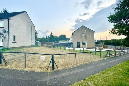
- Price
- Offers Over£42,500
105, Preston Avenue, Lothian East, East Lothian EH32 Scotland
Added on 08/10/2026Building Plot
- Price
- Guide Price£23,000
- Size
- 1.99 acres
Added on 02/07/2026Cheap Land