
Station Road, Burtle, Bridgwater, TA7
- Land size
- 5.12 acres
- Dwelling size
- 3465 sqft
- Bedrooms
- 3
- Bathrooms
- 3
Key Features
- Flexible & Versatile Smallholding
- Convenient edge of village location
- Spaciously extended 6 bed detached farmhouse
- Set in a total of 5.12 acres
- Range of useful outbuildings
- No onward chain
Description
An exceptionally rare opportunity to acquire a versatile smallholding capable of multi-generational living on the outskirts of the village of Burtle. The Farmhouse offers a three bedroom home with a further extension and annexe offering a further three bedrooms. Outside offers a range of agricultural buildings and land.
DESCRIPTION & OUTSIDE
In brief, Station Farm comprises a three bedroom dwelling, two bedroom extension and one bedroom annexe together with a range of agricultural buildings and pasture land.
The Farmhouse
The front door leads through to two reception rooms, both with fire places, a well equipped utility room, downstairs W/C and kitchen. The staircase rises to a landing with three double bedrooms and a large family bathroom.
The Extension
The extension offers scope for multigenerational living with a well-equipped kitchen and utility room, sun room and downstairs W/C. The first floor provides a family bathroom and two double bedrooms, one with a dressing room and en-suite. The extension is currently a separate part of the property, however, there may be the opportunity to connect this to the Farmhouse to create a larger dwelling.
The Annexe
The annexe projects from the extension and offers a reception room, kitchen, double bedroom and W/C. This may again have the ability to be conjoined with the rest of the property or be used as a standalone guest suite.
The property requires modernisation throughout but provides prospective purchasers an opportunity to develop the property to suit individual needs.
Outside
The property offers a large lawned garden with a number of timber storage buildings and a former vegetable patch. There is a smaller garden to the front of the Farmhouse with a patio area.
The Agricultural Buildings
To the rear of the dwelling are two ranges of modern agricultural buildings, one offering two steel portal framed buildings historically used for livestock housing measuring 25.35m x 18.41m and 18.28m x 14.80m with a lean-to off measuring 14.99m x 14.18m. The second group of building consists of a total of eight buildings as follows: two timber monopitch buildings measuring 7.62m x 3.43m and 22.89m x 7.53m, the second with a lean-to off being 7.48m x 6.88m, a mixed timber and steel monopitch building measuring 18.20m x 12.38m, a steel portal framed building measuring 15.01m x 11.06m, two concrete block buildings measuring 5.35m x 4.56m and 12.32m x 7.68m, a Dutch barn measuring 13.73m x 6.24m and a monopitch building with a lean-to to part measuring 25.69m x 6.01m.
The Land
The land extends in total to approximately 3.79 acres (1.53 ha) and comprises two useful enclosures of permanent pasture. The northern field parcel has been infilled over the years being adjacent to the former railway line and the southern parcel has also been ‘made up’ but we have not verified the material that has been imported.
SERVICES & OUTGOINGS
We understand mains water, electric and private drainage are connected.
Council Tax: Somerset Council Band ‘D’.
Drainage Rates: Drainage Rates are payable to the Somerset Drainage Boards Consortium.
CONSUMER PROTECTION REGULATIONS
While we endeavour to make our sales details accurate and reliable, if there is any point which is of particular interest to you please contact the office and we will be pleased to confirm the position for you, particularly if you are contemplating travelling some distance to view the property.
LOTTING
It is anticipated that the property will be offered as a whole, but the Vendor reserves the right to sell the property as a whole or in lots privately or to amalgamate, withdraw, sub-divide, alter, add to or amend any lot or any part prior to the sale. No responsibility can be accepted for any expenses incurred by intending purchasers inspecting properties which have been sold, let or withdrawn.
STATUTORY DESIGNATIONS
The land sits within a SSSI Impact Risk Zone where planning applications are assessed for likely impacts on nearby SSSIs/SACs/SPAs & Ramsar Sites. Immediately to the west of the property is a Scheduled Monument being ‘Wooden Trackways on Chilton Moor, 300m west of Station Farm’.
TOWN AND COUNTRY PLANNING
The land, notwithstanding any description contained in these particulars is sold subject to any Development Plan, Tree Preservation Order, Town Planning Schedule, Resolution or Notice which may be or which may come to be in force, and also subject to any statutory provision of byelaws without any obligation on the part of the Vendors to specify them and the Purchaser shall be deemed to have full knowledge of and to satisfy themselves about the provisions of any such matter affecting the property.
DEVELOPMENT CLAWBACK
The sale will not be subject to development clawback provisions and therefore will be sold free of this encumbrance, which will mean that any benefit of any subsequent change of use and/or planning permission will be retained by the purchaser without the need to pay any uplift to the predecessors in title.
HEALTH AND SAFETY
Our Health and Safety policy requires that all interested parties undertaking viewings, if accompanied by a member of GTH staff, must wear their own Personal Protective Equipment (PPE). If interested parties do not adhere to our policy and view the property unaccompanied (or without PPE) then they do so at their own risk, and we/the seller cannot be held liable for any personal injury or claim for compensation.
TENURE AND POSSESSION
The property is sold as freehold with the benefit of full vacant possession.
RIGHTS OF WAY, WAYLEAVES AND EASEMENTS
We have been informed that Station Farm is accessed as a right by user over a stoned track leading from Station Road to the east. This is indicated by the dashed brown line on the Site Plan
The property is sold and so far as required by the Vendors will be conveyed subject to all easements, quasi-easements, privileges and advantages (whether way of water, drainage, light or laying and maintaining water and other pipes or mains of any nature whatsoever) for the benefit of any other property as the owner, tenants or occupiers thereof now or have been accustomed to use, enjoy or exercise. The property is sold subject to all easements and wayleaves of telegraph and telephone poles and stays and wires, and electric pylons, pipes (whether poles and cables, water, gas and other referred to in these Particulars or not) at present erected on and passing over or under the property, and subject to the Agreements affecting the same (if any) and to the Town and Country Planning Scheme, or County, Local Authority or any other statutory body affecting the same.
ENVIRONMENTAL MANAGEMENT SCHEMES
Our investigations indicate that the subject holding is not subject to any agri-environmental management scheme.
ADDITIONAL INFORMATION
Broadband: FTTP — Superfast broadband is available — highest available download speed 80 Mbps.
Mobile Coverage: Available via EE, O2, THREE and VODAFONE. For an indication of specific speeds and supply or coverage in the area we recommend contacting your own provider.
Flood Risk: According to information from the Environment Agency, the subject property is within Flood Zone 3.
DIRECTIONS
What3words: ///evaporate.trailers.amuses
From the A39, Bath Road, turn north towards the village of Edington on Holywell Road. Continue straight over the crossroads, keeping on Holywell Road and follow the road to the right onto Edington Road. Continue for approximately 1.8 miles where the entrance to Station Farm will be on the left after the bridge over the South Drain and before The Duck public house.
Map Location
Property details
- Tenure
- Freehold
- Council Tax Band
- D
- Date Posted
- 2026-10-01
Market Value Analysis
Compared with 460 Homes with Land listings in South West England (5+ acres).
Energy Performance Certificate
Energy Efficiency Rating
Based on UK Energy Performance Certificate standards (EU Directive 2002/91/EC)
View official EPC certificate ↗
Running costs are one side. Planning activity, flood history and ground risks for this location are in the full report.
Property Brochure
Seen the details? The full report adds the independent checks: planning activity, flood history, heritage and ground.
Utilities & Restrictions
Utilities
- Electricity
- Ask Agent
- Water
- Ask Agent
- Heating
- Ask Agent
- Broadband
- Ask Agent
- Sewerage
- Ask Agent
Rights & Restrictions
- Public Rights of Way
- Ask Agent
- Private Rights of Way
- Ask Agent
- Listed Property
- Ask Agent
- Restrictions
- Ask Agent
Listed status, conservation areas and planning constraints for this location are in the full report.
Property Features
- Accessibility
- Ask Agent
- Parking
- Ask Agent
- Garden
- Ask Agent
Beyond the particulars: planning activity, flood history, heritage and ground risks, checked for this exact spot.
Connectivity
Broadband
Fastest speed available at this postcode
80 Mbps
Superfast
Suitable for
- HD streaming
- Video calls
- Web & social
Mobile signal
Predicted 4G and 5G signal; indoor signal depends on building materials.
Ofcom Connected Nations postcode-level predictions. Speeds and signal are modelled, not measured, and vary between addresses and providers.
Signal is the easy part. Planning activity, flood history and protected designations here are in the full report.
Nearest Schools
Primary
- Catcott Primary School2.1 milesOfsted: Good
- Ages
- 4 to 11
- Pupils
- 127
- Type
- Community school
- Woolavington Village Primary School3 milesOfsted: Good
- Ages
- 2 to 11
- Pupils
- 175
- Type
- Academy sponsor led
- East Huntspill Primary Academy3.4 milesOfsted: Good *
- Ages
- 2 to 11
- Pupils
- 95
- Type
- Academy converter
- Mark First and Pre-School CE Academy3.6 milesOfsted: Requires improvement *
- Ages
- 2 to 9
- Pupils
- 158
- Type
- Academy converter
- Faith
- Church of England
- Kingsmoor Primary School3.7 milesNo Ofsted rating
- Ages
- 4 to 11
- Pupils
- 178
- Type
- Community school
Secondary
- Hugh Sexey Church of England Middle School3.2 milesOfsted: Good
- Ages
- 9 to 13
- Pupils
- 595
- Type
- Academy converter
- Faith
- Church of England
- The King Alfred School an Academy5.8 milesOfsted: Good
- Ages
- 11 to 18
- Pupils
- 1,269
- Type
- Academy sponsor led
- Bridgwater College Academy5.8 milesOfsted report card · Mar 2026
- Ages
- 3 to 16
- Pupils
- 1,561
- Type
- Academy sponsor led
- Chilton Trinity School6.5 milesOfsted: Good *
- Ages
- 11 to 16
- Pupils
- 990
- Type
- Academy converter
- St Dunstan's School7 milesOfsted: Good
- Ages
- 11 to 16
- Pupils
- 529
- Type
- Academy converter
* Latest graded judgement covers quality of education only; no overall grade was issued under the 2024-25 inspection framework.
Distances are straight-line from the advertised location. Source: the national school registers (DfE, Welsh Government, Scottish Government) and Ofsted.
Schools are just the start: sold prices nearby, planning activity and any flood history are in the full report.
Amenities
Supermarket
GP surgery
Pharmacy
Hospital
Straight-line distances from the advertised location. Sources: NHS records, Geolytix supermarket locations, OS Open Greenspace and the national trails registers.
The area stacks up? Now check the location itself: planning nearby, protected designations and past flooding.
Getting Around
Nearest station
Nearest bus stop
Typical drive times
Straight-line distances from the advertised location; drive times are typical free-flow times over OpenStreetMap road data, so allow more at peak. Public transport locations from DfT NaPTAN.
Easy to reach matters. So do planning activity, flood history and ground risks: all in the full report.
Flood Risk
Environment Agency open data, checked around the advertised map pin for the listed acreage. Long-term risk counts flood defences; the planning map's flood zones do not. Provided by LandSale, not the listing agent, and not part of the agent's particulars. Risk varies across a holding, so verify before committing.
Rivers and the sea
Not at the pin: mapped about 20 metres away.
Planning map: Flood Zone 3, about 10 metres away.
Surface water
Not at the pin: mapped about 20 metres away.
These bandings are the summary. Where this location sits on the flood maps, plus planning activity, heritage and ground risks, is in the full report.
Important notice: Information, maps and tags on this page are drawn from the advertising agent's marketing materials or generated automatically. LandSale has not verified them. Relying on these details is at your own risk, always carry out independent checks before committing to a purchase.
LandSale full disclaimer
Marketing information only - not formal particulars. The details on this website are provided for general guidance and do not constitute an offer or contract. Neither LandSale nor the advertising estate/land agent accepts responsibility for any inaccuracy.
1. Source of information
- Listing content: Core description, asking price, tenure, measurements, photographs and planning history originate from the marketing materials of the advertising estate or land agent. LandSale does not author this content and cannot guarantee its accuracy.
- Automated tags & categorisation: Property type, land-use class, acreage bands and similar labels may be applied by machine-learning models. They are intended as a helpful guide only and may not reflect the property's legal status or permitted use.
- Third-party & enriched data layers: Maps, boundary outlines, planning designations, soil reports, broadband coverage and other environmental or location-based insights are licensed from external suppliers. Such data are supplied “as is", may be incomplete or out of date and are subject to change without notice.
2. Verification required
Prospective purchasers must verify critical matters, including but not limited to planning permission, title boundaries, public rights of way, environmental constraints, acreage, services, access and VAT status, through their own inspections, specialist surveys, legal advisers and the selling agent before relying on the information or entering into any contract.
3. No warranty or liability
LandSale gives no warranty, express or implied, as to the accuracy, completeness or fitness for any particular purpose of the information displayed. LandSale shall not be liable for any loss, damage, cost or expense arising directly or indirectly from any use of or reliance on such information, save where liability may not be excluded by law.
4. Updates & feedback
If you believe any detail on this listing is inaccurate, please let us know. We will investigate and, where appropriate, update the listing or notify the agent.
© LandSale | Version 1.3 - August 2026
Listing agent
Greenslade Taylor Hunt, Redhill
Unit 6, 8, 9 The Pound, Redhill, BS40 5TZ
View agent profileSimilar properties for sale
- Price
- £525,000
- Size
- 2.5 acres
Added on 01/10/2026House with Land
- Price
- £850,000
- Size
- 7 acres
Merry Lane, East Huntspill, Highbridge, Somerset, TA9, East Huntspill, Somerset TA9 England
Added on 21/07/2026House with Land
- Price
- Guide Price£795,000
- Size
- 5 acres
Added on 28/05/2026House with Land
- Price
- Guide Price£525,000
- Size
- 2.9 acres
Added on 18/09/2026House with Land
- Price
- Guide Price£750,000
- Size
- 3.89 acres
Ashcott Road, Meare, Glastonbury, BA6, Glastonbury, Somerset BA6 England
Added on 26/03/2026House with Land
- Price
- Guide Price£800,000
- Size
- 2.2 acres
Greinton, Bridgwater, Somerset, TA7, Greinton, Somerset TA7 England
Added on 28/01/2026Farmhouse
- Price
- £850,000
- Size
- 2 acres
Withy Road, West Huntspill, Highbridge, TA9, Puriton, Somerset TA7 England
Added on 29/01/2026Barn Conversion
- Price
- Guide Price£795,000
- Size
- 6.43 acres
Badgworth Lane, Badgworth, Axbridge, BS26, Axbridge, Somerset BS26 England
Added on 21/03/2026Farmhouse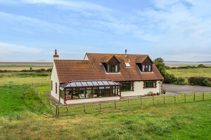
- Price
- Guide Price£525,000
- Size
- 2.3 acres
Added on 06/06/2026House with Land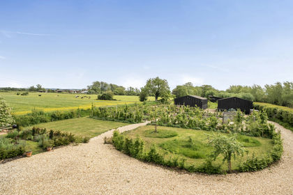
- Price
- Guide Price£650,000
- Size
- 2.2 acres
Added on 16/05/2026Smallholding